
California State Route 215 was a short-lived state highway which existed in the Los Angeles Metropolitain area after the 1964 State Highway Renumbering. California State Route 215 was aligned from US Route 60 at 5th Street in Pomona north to US Route 66 near Claremont via Garey Avenue. California State Route 215 came to be after California State Route 71 was bisected in Pomona due to relinquishment of a portion of Garey Avenue due to the opening of a portion of the Corona Freeway (now Chino Valley Freeway) during 1958. California State Route 215 was deleted by the Legislature during 1965.

The history of California State Route 215
The initial segment of what was to become California State Route 215 was added to the State Highway System as part of the 1909 First State Highway Bond Act. The First State Highway Bond Act defined what would become
Legislative Route Number 19 (LRN 19) as running from Claremont to Riverside. The segment of LRN 19 between Claremont and Pomona would in time become part of California State Route 71. LRN 19 can be seen on the
1918 California Highway Commission Map. The routing of LRN 19 between Claremont and Pomona followed Garey Avenue.


California State Route 71 was announced as one of the original Sign State Routes in the
August 1934 California Highways & Public Works. California State Route 71 originated at US Route 66 near Claremont and followed LRN 19 south towards Pomona. From Pomona, California State Route 71 followed the entirety of LRN 77 to US Route 80 near San Diego.


In 1935 the Division of Highways released County maps which depict routing of California State Route 71. Within
Los Angeles County, California State Route 71 is shown following Garey Avenue along LRN 19 south from US Route 66/LRN 9 in Claremont to US Route 99/US Route 60/US Route 70/LRN 26 at Holt Avenue in Pomona. California State Route 71 briefly multiplexed US Route 60/LRN 19 on Garey Avenue south to 5th Street where the latter split east towards Riverside. California State Route 71 transitioned onto LRN 77 following Garey Avenue and Philadelphia Street to the San Bernardino County line.


The 1936-1937 Division of Highways Map displays California State Route 71/LRN 77 south of Pomona bypassing Chino via an extension of Garey Avenue. The new bypass of Chino tied into Merrill Avenue south of the city of limit of Chino directly towards LRN 177.
The
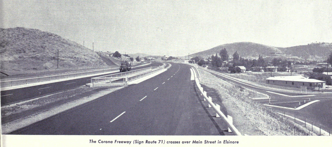
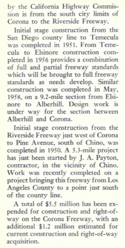
January/February 1958 California Highways & Public Works announced a contract to construct the Temescal Freeway between 5th Street to 0.9 miles south of Riverside Drive in Pomona. The initial segment of the Temescal Freeway is noted to have an anticipated completion during April as an expressway. While not overly stated the Temescal Freeway was intended to be the new alignment of California State Route 71.
The Temescal Freeway name was short lived as the corridor was announced as having been named the "Corona Freeway" in the November/December 1958 California Highways & Public Works. The Corona Freeway name was selected by the California Highway Commission on July 23, 1958. The Corona Freeway corridor is noted to have been selected by the California Highway Commission during 1947 between the Los Angeles County line and the US Route 395 Escondido Freeway.


The
1959 Division of Highways Map displays California State Route 71 in Pomona as a bisected highway. The northern segment of California State Route 71 is shown to follow LRN 19 between Claremont to the US Route 60 along Garey Avenue. The segment of Garey Avenue south to the Corona Freeway is shown to have been relinquished back to Pomona. The southern Segment of California State Route 71 is shown originating at US Route 60 and following the Corona Freeway south towards Chino. The entire Corona Freeway corridor had been added the Freeway & Expressway System during 1959.

The 1964 State Highway Renumbering heavily altered the corridor of California State Route 71. The Legislative Route Numbers were dropped as part of the 1964 State Highway Renumbering in favor of Sign Route designations. California State Route 71 was defined with several segments:
(A) Route 10 to near Pomona to Route 91 via Pomona.
(B) Route 91 to Route 395.
(C) Route 395 near Temecula to Route 74 east of Anza.
The
1964 Division of Highways Map displays the changes to California State Route 71. What had been California State Route 71 along Garey Avenue between US Route 66 in Claremont to US Route 60 in Pomona was designated as
California State Route 215. The establishment of California State Route 215 removed the gap in California State Route 71. California State Route 71 was extended north of US Route 60/5th Street to the Interstate 10 and the San Bernardino Freeway.
1965 Legislative Chapter 1372 deleted California State Route 215 along Garey Avenue between Claremont and Pomona. It is unclear if California State Route 215 ever had any signage or was signed as California State Route 71 prior to being deleted. Former California State Route 71/California State Route 215 along Garey Avenue between Claremont and Pomona no longer appears on the
1966 Division of Highways Map.


Comments