
The last covered bridges of the California State Highway System (California State Route 96)


California has numerous covered bridges which once served the highways and roads of the State.  In modern times most of the existing covered bridges in California have been converted to pedestrian use and a state of preservation.  The California State Highway System had two covered bridge holdouts which were active on California State Route 96 in Siskiyou County until 1950.  This blog examines the history of the Dillon Creek and Clear Creek Covered Bridges which were the last two structures of their kind on a California State Highway System.  Pictured above as the blog cover is the Dillon Creek Covered Bridge as it was prior to being demolished during 1950.  


The history of the Dillon Creek and Clear Creek Covered Bridges

What is now California State Route 96, and the Klamath River Highway was first defined by the 1919 Third State Highway Bond Act as Legislative Route Number 46 (LRN 46).  The original definition of LRN 46 was as follows:

"Klamath River Bridge on LRN 3 (future US Route 99) to LRN 1 (future US Route 101)"

The planned route of LRN 46 and the Klamath River Highway appears on the 1920 California Highway Commission Map.  


The August 1934 California Highways and Public Works announced the original run of Sign State Routes.  The entirety of LRN 46 and the Klamath River Highway was assigned as California State Route 96.  The attached article map displays California State Route 96 being applied over the completed portions of LRN 46 and the Klamath River Highway.  The Klamath River Highway between Klamath Glen and the Yurok Reservation ultimately was never constructed.  


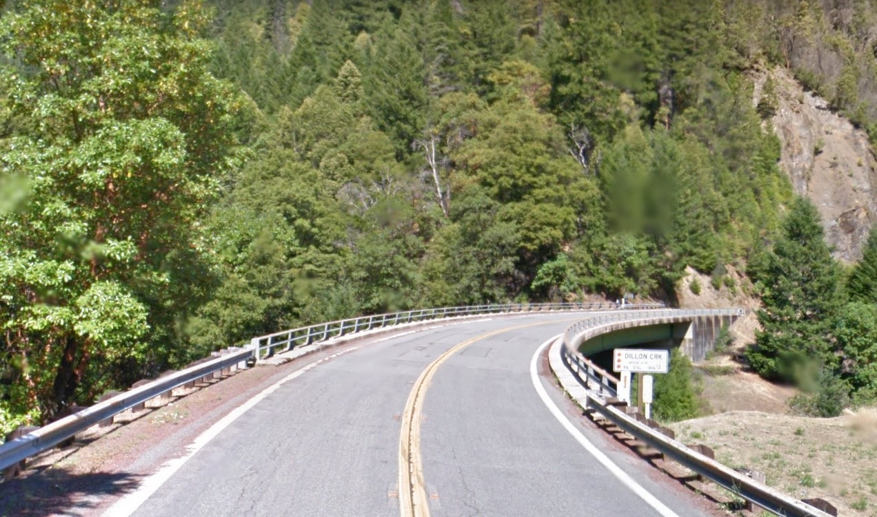
The November/December 1950 California Highways & Public Works contains an article regarding the removal of the last two covered bridges from the State Highway System. The Clear Creek and Dillon Creek Covered Bridges are noted to have been located on California State Route 96 in Siskiyou County. The Clear Creek and Dillon Creek Covered Bridges were constructed during 1921-1922 by the United States Bureau of Public Roads when the Klamath River Highway was in a primitive state of repair. The Clear Creek Covered Bridge is noted to have been built with an eleven-foot-wide road deck whereas the Dillon Creek Covered Bridge had a fifteen-foot nine-inch-wide road deck. The modernized spans over Dillon Creek and Clear Creek are displayed in contrast to their covered bridge predecessors.


The modern Clear Creek Bridge can be found on California State Route 96 at Postmile SIS 32.65.


The modern Dillon Creek Bridge can be found on California State Route 96 at Postmile SIS R16.18.


Comments

Popular posts from this blog

Old River Lock & Control Structure (Lettsworth, LA)

  The Old River Control Structure (ORCS) and its connecting satellite facilities combine to form one of the most impressive flood control complexes in North America. Located along the west bank of the Mississippi River near the confluence with the Red River and Atchafalaya River nearby, this structure system was fundamentally made possible by the Flood Control Act of 1928 that was passed by the United States Congress in the aftermath of the Great Mississippi River Flood of 1927 however a second, less obvious motivation influenced the construction here. The Mississippi River’s channel has gradually elongated and meandered in the area over the centuries, creating new oxbows and sandbars that made navigation of the river challenging and time-consuming through the steamboat era of the 1800s. This treacherous area of the river known as “Turnbull’s Bend” was where the mouth of the Red River was located that the upriver end of the bend and the Atchafalaya River, then effectively an outflow

Interstate 10S and the original Interstate 110 in California

Interstate 10S is a short spur of Interstate 10 along San Bernardino Freeway in downtown Los Angeles.  Interstate 10S begins at the Santa Ana Freeway (US Route 101) and extends east to Interstate 5 where it merges into mainline Interstate 10.  Interstate 10S is one of the oldest freeway segments in Los Angeles having been part of US Routes 60, 70 and 99 when it was part of the corridor of the Ramona Expressway.  The current corridor of Interstate 10S was assigned as Chargeable Corridor H following the passage of the 1956 Federal Highway Aid Act.  Interstate 110 was a short-lived designation which comprised the segment San Bernardino Freeway from US Route 101 to Interstate 5 between 1964-1968.  The original Interstate 110 was dropped as a Chargeable Corridor during 1965 and consolidated as Interstate 10S during 1968.   The original Interstate 110 can be seen as the blog cover photo as it was featured on the 1964 Division of Highways Map.  Below the entire 0.65-mile length of Interstate

Vicksburg Bridge (Vicksburg, MS)

  Located a few hundred feet downriver from the Old Vicksburg Bridge, the Vicksburg Bridge, or the “New” Bridge, serves as the city’s vehicular crossing of the Mississippi River on the main highway connecting Vicksburg with northeastern Louisiana to the west and the state capital of Jackson to the east. The completion of the original Vicksburg Bridge in 1930 was seen as a huge success and the bridge proved to be a profitable entity for both road and railroad interests along the path of the Dixie Overland Highway and the subsequent US Highway 80 corridor. In the years after the creation of the National Interstate Highway System, planning commenced on a new bridge at the site that would relieve the congestion on the existing bridge while providing for a more modern crossing of the river that would be safe for all vehicles. The construction of the new bridge at Vicksburg was completed in 1973 and its design intentionally mimics that of its predecessor nearby. This was due in large part