The segment of US Route 99 from Los Angeles north to Bakersfield was traditionally known in State Highway documents as the "Ridge Route." Even as the Ridge Route was transitioning from curvy mountain grade to the facility now occupied by Interstate 5 the name largely persisted in California Highways & Public Works documents. During modern times the name "Ridge Route" has be usurped in popular lexicon in favor to the nickname known as "The Grapevine." This blog will attempt to decipher the origins of "The Grapevine" and how it came into popular use today. Featured as the blog cover photo is a view of Interstate 5 in Grapevine Canyon and former US Route 99 at Deadman's Curve of the Ridge Route.
This blog is part of the larger Gribblenation US Route 99 Page. For more information pertaining to the other various segments of US Route 99 and it's three-digit child routes check out the link the below.

Note: this blog is not intended to deep dive the history of the corridor of the Ridge Route transitioning as a First State Highway Bond Act Road into modern Interstate 5. The corridor of the Ridge Route is explored in depth in the below Gribblenation blog:
Legend of the Ridge Route; a history crossing the mountains between the Los Angeles Basin and San Joaquin Valley from wagon roads to Interstates
Attempting determine the origin of "The Grapevine" nickname to Interstate 5
Attempting to understand where "The Grapevine" nickname requires some background in Southern California slang and historic context on the Los Angeles-Bakersfield highway corridor. In Southern California slang "The" is often placed front of a name or agency in day-to-day vocabulary. Some common examples would be "The 405" denoting Interstate 405, "The CHP" denoting California Highway Patrol and in the case of this blog "The Grapevine" referencing a segment of Interstate 5.
In 1772 during the period of Alta California acting Spanish Governor Pedro Fages was seeking an inland short cut between San Diego and Monterey. During the expedition a canyon was discovered which had numerous grapevines growing naturally within its walls. This canyon as subsequently named "La Canada de Las Uvas" which roughly translates into "Canyon of the Grapes." Today "Grapevine Canyon" is located what is now on Interstate 5 within Kern County a short distance north from Tejon Pass.
Eventually the corridor over Tejon Pass would become what was known as "El Camino Viejo." Although travel through Grapevine Canyon wasn't infrequent the more popular route was San Emigdio Canyon due to it lining up more directly with western San Joaquin Valley and being a shorter route to Corral Hollow Pass. The path of El Camino Viejo largely was aligned west of Tulare Lake and a rough modern analog can roughly be found in the form of California State Route 33 (CA 33).
After California had become an American State the existing alignment of El Camino Viejo was still in use as an inland overland route. By 1853 gold claims were struck along the Kern River which led to the Kern River Gold Rush. At this point the entirety of the Sierra Nevada Range had become attractive for prospectors looking to make money on the new mining claims. El Camino Viejo being routed west of the Tulare Lake watershed was suddenly no longer a viable route for the majority of travelers through San Joaquin Valley. A new route from Stockton to Los Angeles following the Sierra Nevada Foothills along the eastern edge of San Joaquin Valley known as the Stockton-Los Angeles Road was subsequently. In San Joaquin Valley the path of the Stockton-Los Angeles Road followed the general path of CA 65, particularly north of the Kern River.
Originally the Stockton-Los Angeles Road utilized an established path from San Joaquin Valley south over the 5,285-foot Old Tejon Pass in the Tehachapi Mountains to Antelope Valley. At the time Old Tejon Pass was simply known as "Tejon Pass" and was an ancient Native American Trail used to traverse the Tehachapi Mountains.
In 1853 Castac Pass through Grapevine Canyon west of the Old Tejon Pass was surveyed by Robert S. Williamson of the Army Corps of Engineers for a possible path of Transcontinental Railroad. The 1853 surveying expedition found Castac Pass through Grapevine Canyon to be a far more viable route for travelers and the primary alignment was of the Stockton-Los Angeles Road was shifted west from Old Tejon Pass. Castac Pass had a far lower terminal elevation at approximately 4,200 feet above sea level and had a gentler grade through Grapevine Canyon.
In 1854 a U.S. Army Garrison was established at Fort Tejon in Grapevine Canyon near modern Lebec to protect settlers and travelers along the Stockton-Los Angeles Road. In time Castac Pass became known as Fort Tejon Pass and eventually simply Tejon Pass.
The Stockton-Los Angeles Road would persist as the overland highway between Los Angeles and San Joaquin Valley into the early 20th Century. Although the State Highway System had become during 1895 it wasn't until the advent of the 1909 First State Highway Bond Act that it would become truly relevant. The 1909 First State Highway Bond Act was approved by voters in 1910 which added 3,052 miles of roadways to the State Highway system. One of the routes included in the 1909 First State Highway Bond Act was a new 359-mile-long State Highway from Sacramento to Los Angeles. This highway was the genesis point of the Ridge Route and was eventually assigned Legislative Route Number 4 ("LRN 4") in 1916.
The planned alignment of LRN 4 from Fresno to Los Angeles can be seen on the May 1913 California Highway Bulletin. The selected route between Bakersfield and Los Angeles is shown as a plotted projection. A rejected proposed route via Tehachapi Pass and Lancaster is also displayed. The survey for what would become the Ridge Route was ordered on January 25th, 1912.

The May 1913 California Highway Bulletin details reasonings for the then named "Tejon Route" being chosen over the alternate route through Tehachapi Pass and Lancaster. The primary reasoning for the Tejon Route being chosen was the 60 miles savings by taking a more direct route from San Fernando north to San Joaquin Valley via Castaic Ridge. Easier grades over the Tejon Route compared to Tehachapi Pass, better access to land for development, better drainage grades, and fewer bridges being needed are all cited as reasons that the Tejon Route ultimately was the favored alignment of LRN 4. Notably the survey photo does refer to the Los Angeles-Bakersfield segment of LRN 4 as the "Tejon-Castaic Ridge Route."


Confusingly the accompanying article in the July 1916 California Highways & Public Works refers to the Los Angeles-Bakersfield segment of LRN 4 as the Castaic-Tejon Ridge Road, Castaic Road, Castaic Ridge Road and as Ridge Route.
The California Highway Bulletin would end as a publication in 1916 and would be succeeded by the California Highways & Public Works publication during January of 1924. The
January 1924 California Highways & Public Works refers to what had been the Castaic-Tejon Ridge Route simply as just the "Ridge Route" in an article stub referring to convict road labor camps.
The
July 1926 California Highways & Public Works notes the Grapevine grade to be part of the northern end of the Ridge Route. Notably the US Route System would be created by the American Association of State Highway Officials during November 1926 which brought US Route 99 (US 99) to the Ridge Route.

The
July 1932 California Highways & Public Works discusses the potential annual savings from the upcoming "Alternate Ridge Route" and the rationales behind its construction. Notably the Ridge Route is noted to still comprise the entire Los Angeles-Bakersfield corridor of US 99/LRN 4.
The October/November 1933 California Highways & Public Works details the opening Ridge Route Alternate between Castaic and Gorman. The Castaic-Gorman segment of Ridge Route Alternate opened to traffic on October 29th, 1933. The article notes Ridge Route Alternate was a bypass of the more haggard segments of the orginal Los Angeles-Bakersfield Ridge Route corridor.


The
September 1934 California Highway & Public Works discusses the Grapevine Grade between Fort Tejon 5.2 miles north to Grapevine Village being modernized from the Old Ridge Route alignment. The new Grapevine Grade is cited to have opened on September 11th, 1934. The Grapevine Grade is explicitly stated to be part of the Ridge Route in the article stub.
The
August 1935 California Highways & Public Works discusses the realignment of US 99/LRN 4 around Deadman's Curve in Grapevine Canyon. The bypass of Deadman's Curve opened to traffic on July 22nd, 1935. The article stub notes Grapevine Canyon as a segment of the larger Ridge Route.
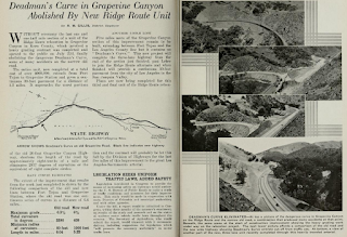
The final upgrade to the Old Ridge Route in Grapevine Canyon was between Lebec and Fort Tejon which opened on August 31st, 1936, according to the October 1936 California Highways & Public Works. The final Grapevine Canyon Grade upgrade is stated to be part of the extension of Ridge Route Alternate and the final replaced segment of the older Ridge Route. The article stub does reference Grapevine Canyon as "The Grapevine" in numerous paragraphs. This appears to be the first reference something resembling the modern nickname "The Grapevine" in any official state sourced document. It is unclear if author R.M. Gillis coined the term "The Grapevine" or if it was already in use as a local nickname for the Ridge Route in Grapevine Canyon.


The
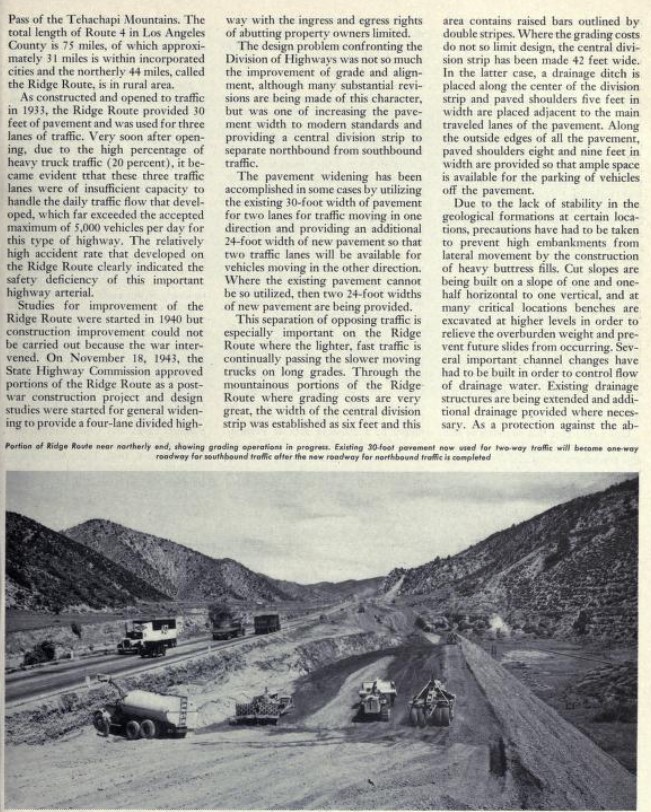
July/August 1949 California Highways & Public Works provides an update on the progress of US 99/LRN 4 on the Ridge Route being expanded to four lanes. The first paragraph goes onto state that the definition of the Ridge Route was now the 44 miles of US 99/LRN 4 from the city limits of Los Angeles to the Kern County line. The article stub refers to the 14 miles of US 99/LRN 4 north from the Kern County Line to the floor of San Joaquin Valley as "grapevine." This appears to be the first instance where state sources truncated the definition of the Ridge Route and made a clear definition that The Grapevine/Grapevine Grade was an entirely separate segment.
On June 29th, 1956, the Federal Highway Aid Act of 1956 was signed into law on the Federal Level. The Federal Highway Aid Act of 1956 was the genesis point of the Interstate Highway System which would in the coming decade sew the demise via of US 99 in California largely in favor of Interstate 5.
The
September/October 1960 California Highways & Public Works features the completion of the US 99/Interstate 5/LRN 4 freeway corridor through Grapevine Canyon. The corridor of Grapevine Canyon is clearly defined in the article as the Grapevine Grade and no longer tied to that of the Ridge Route. The Division of Highways seems to have preferred using "Grapevine Grade" over the subjectively less official sounding "The Grapevine." Later California Highways & Public Works publications would on occasion use "The Grapevine" as a nickname for the Grapevine Grade.
The AASHO Renumbering database shows that US 99 was approved to be truncated out of California to Ashland, Oregon by the AASHO Executive Committee on June 29th, 1965. This measure would have become effective on New Year's Day 1966. This measure left only Interstate 5 signed on the remaining active segment of the Ridge Route and Grapevine Grade.
The
January/February 1967 California Highways & Public Works still refers to the planned upgrades to the corridor of Interstate 5 between Castaic and Gorman as part of the Ridge Route. It is clear as the California Highways & Public Works publication was ending that the Division of the Highways considered the Ridge Route to be an operating segment of Interstate 5.

Interstate 5 would be completed to freeway standards between Castaic north to the Kern County Line by mid-year 1970. The new alignment of Interstate 5 was shifted above what was built as Ridge Route Alternate through Piru Gorge. Pyramid Dam was constructed in Piru Gorge which bisected the grade of Ridge Route Alternate. It is unclear when the definition of the Ridge Route on Interstate 5 between the Los Angeles City Limit and Kern County Line was largely lost to time. The Grapevine Grade and nickname of "The Grapevine" has seemingly stood the test of time. Most people seem to refer to "The Grapevine" to either the corridor Interstate 5 in Grapevine Canyon or Castaic-Grapevine Village.
Further Reading
Heading north on US Route 99 to Bakersfield?
Heading south on the 1926-1934 alignment of US Route 99 to Los Angeles and Redlands?
Heading south on the 1926-1934 alignment of US Route 99 to Los Angeles and Redlands?


Comments