
Hawaii Route 99

Hawaii Route 99 is a 23.84-mile State Highway located on the Island of Oahu.  Hawaii Route 99 begins near Joint Base Pearl Harbor-Hickam at Interstate H-1 and largely follows the Kamehameha Highway north to Hawaii Route 83/Hawaii Route 930 in Haleiwa.  Hawaii Route 99 is also comprised as part of the Farrington Highway, Wilikina Drive and Kamananui Road.  


This page is part of the Gribblenation Oahu Highways page.  All Gribblenation and Roadwaywiz media related to the highway system of Oahu can be found at the link below:

https://www.gribblenation.org/p/gribblenation-oahu-highways-page.html


Part 1; the history of Hawaii Route 99

Prior to the Statehood the first signed highways within Hawaii Territory came into existence during World War II.   During World War II the territory of Hawaii saw an influx of military activity following the attack on Pearl Harbor on December 7th, 1941.  Numerous Military Routes and early Hawaii Routes were signed through the Hawaiian Territory to aid military personnel in navigating the islands.  Military Highways were assigned US Route style shields whereas lesser highways were assigned an early variation of what is now the Hawaii Route Spade.  

A 1946 Army Map of the Island of Oahu shows the future current corridor of Hawaii Route 99 as part of Military Route 1 on Kamehameha Highway from Hickam Air Force Base to Wahiawa via Ewa Junction, Military Route 3 on Wilikina Drive, Military Route 17 on Kamananui Road and Military Route 12 on Kamehameha Highway to the outskirts of Haleiwa.  A full version of the 1946 Army Map of Oahu can be seen on hawaiihighways.com here


Circa 1955 following the conclusion of World War II the United States Bureau of Public Roads renumbered the Hawaii Route System.  The 1955 Hawaii Route Renumbering saw most of the conventions utilized by the current Hawaii State Route System established.  Primary Hawaii Routes were given two-digit numbers whereas Secondary Hawaii Routes were given three-digit numbers.  The Hawaii Routes were assigned in sequence for what Island/County they were located on coupled with what Federal Aid Program number they were tied to.  In the case of Oahu the Island was assigned numbers in the range of 60-99.  

Hawaii Route 99 was a new routing beginning at Ewa Junction northwest to Kaena Point.  Hawaii Route 99 was aligned on Kamehameha Highway from Ewa Junction to Wahiawa, Wilikina Drive, Kaukonahua Road and Farrington Highway to Kaena Point.  In the case of Hawaii Route 99 to Kaena Point it was aligned directly over the grade of the Oahu Railway which went defunct during 1947.  The initial alignment of Hawaii Route 99 can be seen on the 1959 Gousha Highway Map of Hawaii.  


On August 21st, 1959, Hawaii became the 50th State which saw its profile rise significantly.  The Interstate System in Hawaii was authorized as part of the 1960 Statehood Act.  The 1960 Statehood Act authorized Interstates H-1, H-2 and H-3 on the Island of Oahu.  The building of the Interstate System on Oahu would greatly affect numerous Hawaii Route corridors including that of Hawaii Route 99.  

Much of the corridor of Interstate H-1 east of downtown Honolulu was inherited from Hawaii Route 72 and the existing Mauka Lateral.   Hawaiihighways.com details the construction history of Interstate H-1 on their Oahu page.  The first segment of the Lunalilo Freeway to be constructed as Interstate H-1 between Exit 25B east to 26A was completed by 1965.  This segment can be seen under construction in the 1965 Hawaii Department of Transportation photo below.  

Interstate H-1 on the Queen Liliuokalani Freeway from Exit 5 (Hawaii Route 76/Hawaii Route 750) to its western terminus opened during 1967.  The remainder of the Lunalilo Freeway segment of Interstate H-1 in Honolulu was completed by July 1969.  The Queen Liliuokalani segment of I-H1 was completed east to Hawaii Route 78 (future Interstate H-201) by 1971.  The Queen Liliuokalani segment of Interstate H-1 was gradually extended east of Hawaii Route 78 to the Lunalilo Freeway segment of Interstate H-1 culminating in the completion of the Intestate during May of 1986. 

Unlike the other Interstate corridors of Oahu Interstate H-2 was relatively uncontroversial and three general routing options were discussed via public hearing during October 1962.  Construction of the Wahiawa Interchange would begin during 1971.  The first two northbound miles of Interstate H-2 opened to traffic from Interstate H-1 to Mililani Cemetery on October 3rd, 1974.  The opening ribbon cutting ceremony of the first two miles of Interstate H-2 can be seen in the October 4th, 1974 Honolulu Advisor.  


The remaining portion of Interstate H-2 north to Wahiawa opened on February 21st, 1977.  The opening ceremony for the completed Interstate H-2 was announced in the February 16th, 1977 Honolulu Advisor.  


The construction of Interstate H-1 and Interstate H-2 led to a realignment of Hawaii Route 99. The 1983 USGS Maps of Oahu show Hawaii Route 99 with substantial changes.  Hawaii Route 99 is shown originating at Interstate H-1 near Hickam Village and following Kamehameha Highway north to the vicinity of what was Ewa Junction over what had been Hawaii Route 90.  Approaching Ewa Junction the Kamehameha Highway had been obliterated by the construction of Interstate H-1 and Interstate H-2.  Hawaii Route 99 followed a short jog via Farrington Highway to reach the next segment of Kamehameha Highway. 


From Ewa Junction Hawaii Route 99 followed its original corridor via Kamehameha Highway north to Wahiawa.  Hawaii Route 99 followed its alignment Wilikina Drive but split onto Kamananui Road over what had been Hawaii Route 82 back to Kamehameha Highway.  


North of Wahiawa Hawaii Route 99 was realigned on Kamehameha Highway over what had been Hawaii Route 82 to Hawaii Route 83/Hawaii Route 930 in Haleiwa.  


Part 2; a drive on Hawaii Route 99

Northbound Hawaii Route 99 can be seen beginning from a junction branching north from Hawaii Route 92/Nimitz Highway.  


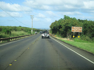
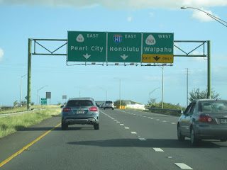
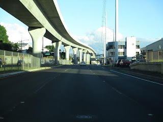
Hawaii Route 99 northbound initially begins on Kamehameha Highway which follows the eastern shore of Pearl Harbor.  The incomplete Honolulu Rail Transit can be seen along Hawaii Route 99/Kamehameha Highway in the vicinity of Pearl Harbor.  


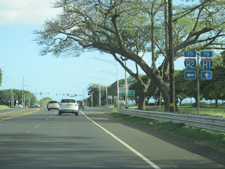
Hawaii Route 99/Kamehameha Highway northbound serves as primary access to Pearl Harbor National Memorial and the Ford Island Bridge.  North of the Ford Island Bridge a junction gantry on Hawaii Route 99/Kamehameha Highway displays Hawaii Route 78 which was the previous designation of what is now Interstate H-201.  Hawaii Route 99/Kamehameha Highway northbound splits left from a junction with Interstate H-201.  


Hawaii Route 99/Kamehameha Highway follows the northern shore Pearl Harbor.  Hawaii Route 99 northbound briefly splits onto Farrington Highway to bridge the gap in Kamehameha Highway at the Interstate H-1/Interstate H-2 junction.


Hawaii Route 99 northbound splits from Farrington Highway at the Hawaii Route 7101 junction back onto Kamehameha Highway.  


Hawaii Route 99 follows Kamehameha Highway northward to Wahiawa where it junctions Interstate H-2.  Hawaii Route 99 northbound passes under Interstate H-2 and makes a left hand turn at Wilikina Drive whereas Kamehameha Highway carries Hawaii Route 80 through Wahiawa. 


Hawaii Route 99 northbound intersects Hawaii Route 76 at Kunia Road.  From Kunia Road Hawaii Route 99 follows Wilikina Drive around Wahiawa and splits onto Kamananui Road. 


Hawaii Route 99 northbound follows Kamananui Road back to Kamehameha Highway at the north terminus of Hawaii Route 80.  


Hawaii Route 99 follows Kamehameha Highway north to its terminus at Hawaii Route 83/Hawaii Route 930 in Haleiwa. 


Below Hawaii Route 99 can be south of Haleiwa on Kamehameha Highway.  


Below Hawaii Route 99 can be seen splitting onto Kamananui Road at the Hawaii Route 80 junction.  


Below Hawaii Route 99 southbound can be seen after it transitions onto Wilikina Road.  


Hawaii Route 99 southbound follows Wilikina Road into Wahiawa where it intersects Hawaii Route 76 at Kunia Road.  


Hawaii Route 99 southbound follows Wilikina Road onto the beginning of Interstate H-2 and departs via Exit 9.  


Hawaii Route 99 from Interstate H-2 Exit 9 turns south onto Kamehameha Highway.  Hawaii Route 99 follows Kamehameha Highway south to a junction with Interstate H-1 and Interstate H-2.  


Hawaii Route 99 southbound transitions onto Farrington Highway.  


Hawaii Route 99 southbound intersects Interstate H-2 and transitions back onto Kamehameha Highway.  


Hawaii Route 99 southbound follows Kamehameha Highway along eastern shore of Pearl Harbor to its terminus at Interstate H-1 and Hawaii Route 92. 


During June 2019 Dan Murphy of the Roadwaywiz YouTube Channel (and Gribblenation) featured real-time drives on Hawaii Route 99.  Below Hawaii Route 99 can be observed northbound.  


Below Hawaii Route 99 can be observed southbound.  


Comments

Popular posts from this blog

Tulare Lake returns

During the winter of 2023 California experienced one of the wettest seasons in recent decades.  Enough snow and water were deposited into the Sierra Nevada Mountains that the runoff was enough to partially reform Tulare Lake within San Joaquin Valley.  Tulare Lake was once the largest lake west of the Mississippi River by surface area.  Tulare Lake has been largely dried for the past century due to irrigation divisions and upstream impoundments.  This blog will examine the history of Tulare Lake and its recent return.  Pictured as the blog cover is Tulare Lake from 19th Avenue in Kings County during early May 2023.  Tulare Lake can be seen near its maximum extent below on the 1876 P.Y. Baker Map of Tulare County .   Part 1; the history of Tulare Lake Tulare Lake is the largest remnant of Lake Corcoran.  Lake Corcoran once covered much of the entire Central Valley due to being it being located at a in natural low point from where mountain run-off would accumulate.  Lake Corcoran is thou

Former US Route 101 through Sargent

  Sargent is a ghost town and siding of the Southern Pacific Railroad located in southern Santa Clara County.  The original alignment of US Route 101 was aligned through Sargent via what is now known as Old Monterey Road.  Sargent was bypassed gradually due to shifts of the alignment of US Route 101 which occurred during 1941 and 1950.  Pictured as the blog cover is a view on Old Monterey Road which is now no longer accessible to the general public.  Below is a scan of the 1935 Division of Highways Map of Santa Clara County which depicts the original alignment US Route 101 through Sargent.   Part 1; the history of US Route 101 in Sargent Sargent lies on land which was once part of Rancho Juristac.  During 1856 James P. Sargent purchased Rancho Juristac and plotted what was known as Sargent Ranch.  By 1869 the Southern Pacific Railroad coast line reached the relocated town site of Gilroy.  The Southern Pacific Railroad coast line would be constructed through Chittenden Pass by 1871 whic

California State Route 60/Former US Route 60/70 through the Moreno Valley Badlands west to Riverside

This past month I drove California State Route 60 through the Moreno Valley Badlands westward towards the City of Riverside.  CA 60 through the Moreno Valley Badlands was once part of the corridors of US Route 60 and US Route 70. The present route of CA 60 is a 70 mile (76 counting multiplex) slice of former US 60 between downtown Los Angeles east to I-10 near Beaumont.  The vast majority of CA 60 aside from a small section in the Moreno Valley Badlands is presently a freeway grade. For me CA 60 holds some personal history as it was the route I used most frequently accessing work sites in the Inland Empire circa 2011-2013.  Despite what many others probably would say I always really enjoyed the Moreno Valley Badlands portion of CA 60.  Considering I frequently worked on US 60 through Arizona and New Mexico the route holds even more appeal.  I even have a CA 60 shield hanging up in my garage. Part 1; History of Roadways in the Moreno Valley Badlands CA 60 between B