Circa 1955 following the conclusion of World War II the United States Bureau of Public Roads renumbered the Hawaii Route System. The 1955 Hawaii Route Renumbering saw most of the conventions utilized by the current Hawaii State Route System established. Primary Hawaii Routes were given two-digit numbers whereas Secondary Hawaii Routes were given three-digit numbers. The Hawaii Routes were assigned in sequence for what Island/County they were located on coupled with what Federal Aid Program number they were tied to. In the case of Oahu the Island was assigned numbers in the range of 60-99.
The purpose of this blog is to examine each unsigned current Hawaii Route on Oahu. Featured as the blog cover is the Middle Street overpass from eastbound Interstate H-1 which is part of unsigned Hawaii Route 7415. Note: the unsigned Hawaii Routes on this page are sourced from the list provided on hawaiihighways.com.
This page is part of the Gribblenation Hawaii Roads series. A compellation of all Hawaii-related media from both Gribblenation and RoadwayWiz can be found by clicking
here.
Hawaii Route 901
Hawaii Route 901 consists of 1.4-miles of Fort Barette Road between Interstate H-1 Exit 2 south to unsigned Hawaii Route 8945 at Enterprise Avenue. Hawaii Route 901 according to hawaiihighways.com was sourced from Federal Aid Primary 1901 during the late 1960s.
Hawaii Route 901 can be seen on the 1968 USGS Map of the Barbers Point area. Hawaii Route 901 can be seen providing direct access to the Puu Kapolei Naval Reservation.
Hawaii Route 7141
Hawaii Route 7141 consists of 1.5 miles of Iroquois Road from Hawaii Route 76/Fort Weaver Road east to the gate of Lualualei Naval Ammunition Depot West Loch Branch. Hawaii Route 7141 used to be Hawaii Route 764 and still appears as such on Google Maps.
Hawaii Route 764/Iroquois Road appears on the 1968 USGS Map of Honouliuli.
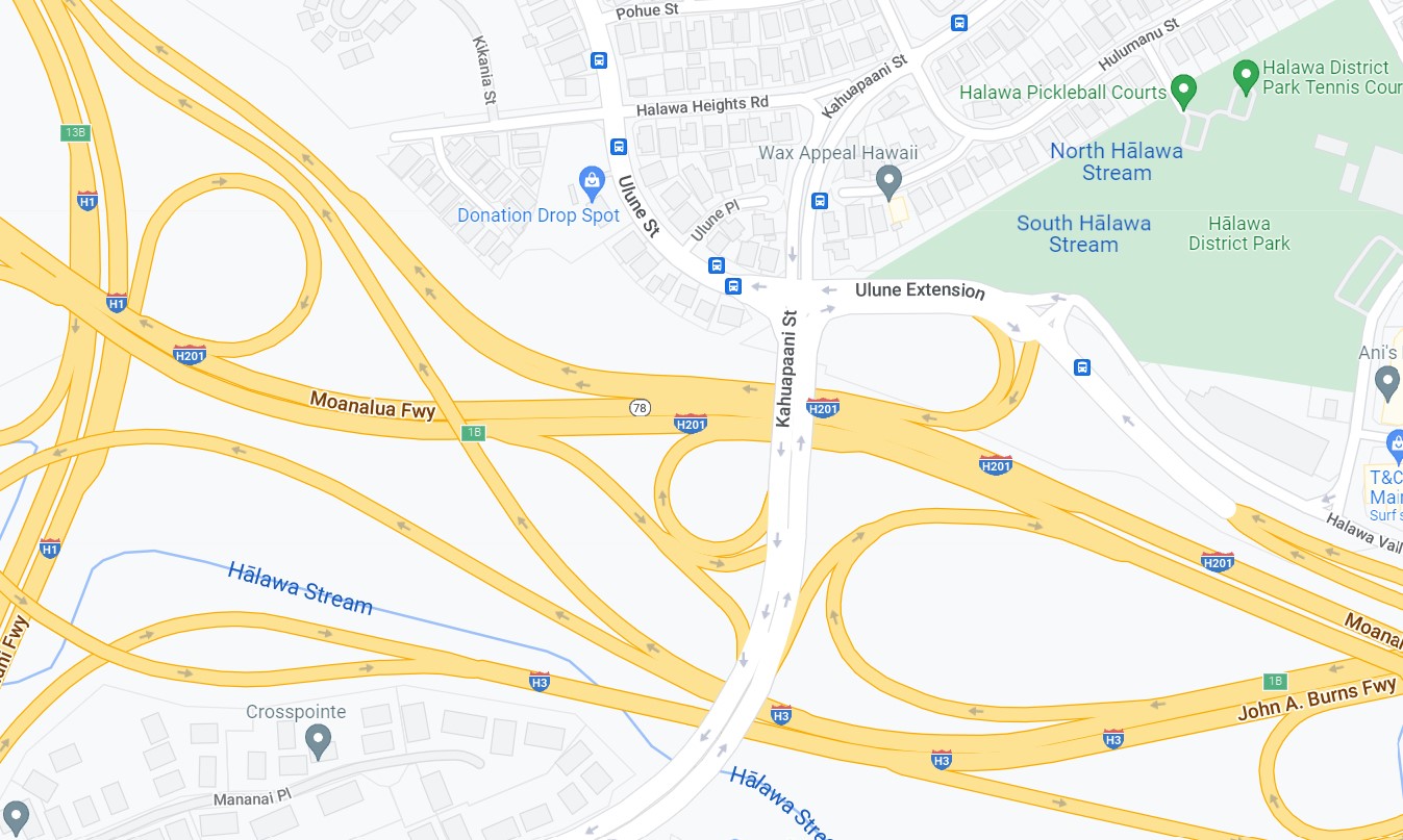
Hawaii Route 7239
Hawaii Route 7239 consists of 0.1 miles of the Ulene Street from unsigned Hawaii Route 7241/Kahuapaani Street to Halawa Heights Road. It is not clear why such a short segment of road is part of the Hawaii State Highway network.
Hawaii Route 7241
Hawaii Route 7241 consists of 1 mile of Kahuapaani Street and 1.3 miles of Halawa Heights Road from former Hawaii Route 67/Hawaii Route 670/Salt Lake Boulevard north to Marine Corps Camp Smith.
The 1968 USGS Map of Halawa indicates what is now Hawaii Route 7241 on Halawa Heights Road was once Hawaii Route 710.
Hawaii Route 7345
Hawaii Route 7345 consists of 0.6 miles of Jarrette White Road from Interstate H-201/Hawaii Route 7310 north to Tripler Medical Center. Signage from Hawaii Route 7310/Puuloa Road northbound implies Jarrette White Road is part of Hawaii Route 7310 to Tripler Medical Hospital. Jarrette White Road may have been once part of former Hawaii Route 66.
Hawaii Route 7350
Hawaii Route 7350 consists of 0.6 miles of Bougainville Drive from Radford Drive north to former Hawaii Route 67/Hawaii Route 670/Soda Lake Boulevard. The purpose of Hawaii Route 7350 is unclear, but it does access numerous retail facilities.
Hawaii Route 7351
Hawaii Route 7351 consists of 0.2 miles of Radford Drive east of Bougainville Drive/Hawaii Route 7350. The purpose of Hawaii Route 7351 appears unclear, but it does access numerous military Post Exchange facilities.
Hawaii Route 7401
Hawaii Route 7401 consists of 0.1 miles of Kamehameha Highway from Interstate H-1 Exit 18B and Hawaii Route 92 to Hawaii Route 7415/Middle Street. This segment of Kamehameha Highway was once part of Hawaii Route 90 which was bisected by the construction of Interstate H-1.
From Hawaii Route 92/Nimitz Highway eastbound traffic can access Hawaii Route 7401/Kamehameha Highway by following the signage to Dillingham Boulevard.
Hawaii Route 7413
Hawaii Route 7413 consists of 0.4 miles of Liliha Street in downtown Honolulu between former Hawaii Route 90 at Dillingham Boulevard north to Interstate H-1. For a brief time Liliha Street from Dillingham Boulevard to Hawaii Route 98/Vineyard Boulevard was the eastern terminus of Hawaii Route 90.
The entirety of Hawaii Route 7413 appears as Hawaii Route 97 on a 1968 Hawaii Department of Transportation Document titled
Proposed Interstate H-4.
Hawaii Route 7415
Hawaii Route 7415 consists of 0.5 miles of Middle Street from former Hawaii Route 90 (Hawaii Route 7401) at Kamehameha Highway north to King Street. This segment of Middle Street acted as a connector between the disconnected Queen Liliuokalani Freeway and Lunalilo Freeway segments of Interstate H-1 until a direct connection was made in 1986. The interim connector on Middle Street between the Queen Liliuokalani Freeway and Lunalilo Freeway can be seen on the 1983 USGS Map of Honolulu.
Hawaii Route 7415/Middle Street can be viewed from eastbound Interstate H-1 as it is transitioning from the Queen Liliuokalani Freeway to the Lunalilo Freeway. Notably the Middle Street Interchange of Interstate H-1/Interstate H-201 is the only segment of the latter which is below Interstate standards.
Hawaii Route 7601
Hawaii Route 7601 consists of 0.1 miles of Old Waialae Road from Interstate H-1 Exit 25A to King Street. Hawaii Route 7601 can only be accessed traveling westbound to King Street.
Hawaii Route 7601/Old Waialae Road was part of Hawaii Route 72 before the Lunalilo Freeway Corridor of Interstate H-1 in Honolulu was complete. Hawaii Route 72 can be seen using Old Waialae Road to access the Lunalilo Freeway on the
1959 Gousha Highway Map of Hawaii.
Hawaii Routes 8940, 8945 and 8955
Hawaii Routes 8940, 8945 and 8955 were all designated in the 2000s in the redeveloped areas of former Naval Air Station Barbers Point. Hawaii Route 8940 consists of 3.4 miles of Franklin D. Roosevelt Avenue from Geiger Road west to Kamokila Boulevard.
Hawaii Route 8945 consists of 1 mile of Enterprise Avenue south from Hawaii Route 8940/Franklin D. Roosevelt Avenue to Midway Street.
Hawaii Route 8955 consists of 2.7 miles of Coral Sea Road from Hawaii Route 8940/Franklin D. Roosevelt Avenue south to Coast Guard Air Station Barbers Point.
`


Comments