When US Route 60 was extended into California during the early 1930s it was aligned towards a terminus in Los Angeles. From Beaumont US Route 60 followed the original Jack Rabbit Trail west through the Moreno Valley Badlands via Legislative Route Number 19 towards Riverside. The original Jack Rabbit Trail was a narrow and inadequate roadway which was replaced by a modernized grade during mid-1930s which is still in use as part of California State Route 60. For a brief time, US Route 70 multiplexed US Route 60 via Jack Rabbit Trail in its first route description upon being extended to California. Above as the blog cover is a view on Jack Rabbit Trail facing eastward into the Moreno Valley Badlands. Below is a snipped image from the 1935 Division of Highways Map of Riverside County which depicted US Route 60 and US Route 70 in the Moreno Valley Badlands on Jackrabbit Trail.
Part 1; the history of US Route 60-70 on Jack Rabbit TrailWhat became US Route 60 (US 60) on Jack Rabbit Trail between Beaumont and Riverside was part of Legislative Route Number 19 (LRN 19). LRN 19 was originally defined during the 1909 First State Highway Bond as a route running from Riverside west to Claremont. In 1931 LRN 19 was extended east to Beaumont through the Moreno Valley Badlands via Jack Rabbit Trail. The new route of LRN 19 east from Riverside to Beaumont first appears on the 1932 Division of Highways State Map.

According to The Press Enterprise
Jack Rabbit Trail was opened during February 1897. Jack Rabbit Trail was constructed following public interest in building a direct road from Riverside east to Beaumont. Jack Rabbit Trail is described as having been built without a survey and having grades approaching 25% in places. In 1914 the Riverside County Highway Commission passed bonds to rebuild Jack Rabbit Trail to a then modernized standard. Reconstruction of Jack Rabbit Trail began in 1915 and was completed by October 1916. Jack Rabbit Trail can be seen connecting Beaumont west to Riverside through the Moreno Valley Badlands on the
1917 California State Automobile Association Map. Ultimately Jack Rabbit Trail would be paved by Riverside County during 1924.

As originally envisioned in the early drafts of US Route System what became US 66 in California was intended to be US 60. The designation of the Chicago-Los Angeles corridor was intended to carry a X0 route number given it was to denote a major east/west US Route. Ultimately the State of Kentucky petitioned to have a X0 US Route and the Chicago-Los Angeles corridor became US 66 in the finalized US Route System created by the American Association of State Highway Officials (AASHO) during November 1926.
US 60 would rapidly be extended after the US Route System was created and would come into play in California during the early 1930s. A letter from the AASHO Executive Secretary to the California State Highway Engineer dated Marth 30th, 1931 noted that US 60 had been tentatively approved to be extended to California during the AASHO Executive Committee on May 26th, 1930. The approval of US 60 being extended to California carried the stipulation that the Colorado River Bridge in Blythe be purchased by the California Division of Highways and Arizona State Road Department. The letter noted California and Arizona had taken steps through their respective legislatures to purchase the Colorado River Bridge and the terminus of US 60 to be at an undisclosed location in Los Angeles.


A letter from the California State Highway Engineer to the AASHO Executive Secretary on April 13th, 1931, noted legislation to purchase the Colorado River Bridge had been passed in California. The purchase of the Colorado River Bridge effectively made the extension of US 60 into California active.
The California State Highway Engineer submitted a recommended routing of US 60 to the AASHO Executive Secretary on September 8th, 1931. The route description of US 60 show as ending in Los Angeles by way of Pomona at an undisclosed terminus. The routing of US 60 defined it as following Jack Rabbit Trail from Beaumont west through the Moreno Valley Badlands towards Riverside.
The April 1932 California Highways & Public Works notes the Riverside Chamber of Commerce made a request to the California Highway Commission to replace existing US 60/LRN 19 on Jack Rabbit Trail.
The
January/February 1933 California Highways & Public Works describes the replacement alignment of US 60/LRN 19 Jack Rabbit Trail as being funded for the 1933-1935 Fiscal Years. The replacement of Jack Rabbit Trail was part of a 19-mile overall realignment of US 60/LRN 19 from Beaumont west to Riverside.
West from Jack Rabbit Trail the initial alignment of US 60/LRN 19 followed:
- US 60/LRN 19 turned northwest on Gillman Springs Road to Alessandro Boulevard.
- US 60/LRN 19 headed westward through Moreno (modern Moreno Valley) to what became US 395 (post-1934) which was on what is now known as Old 215.
- US 60/LRN 19 headed northwest on an alignment largely under modern I-215/CA 60 to 8th Street (now University Avenue) in Riverside.
A September 1934 exchange of letters from the California State Highway Engineer and AASHO acknowledged US 70 had been extended into California with an endpoint following entirety of US 60. The routing definition of US 70 indicated it would multiplex US 60/LRN 19 through the Moreno Valley Badlands via Jack Rabbit Trail.


The multiplex of US 60/US 70/LRN 19 even made commercial maps such as the
1935 Goshua Highway Map of California.As noted in the intro the alignment of US 60/US 70/LRN 19 from Beaumont west to Riverside is made clear on the 1935 Division of Highways Map of Riverside County.US 70 is shown in the 1936 US Route descriptions provided by the California Highway Commission to have been realigned onto US 99/LRN 26 between Beaumont and Pomona. The realignment of US 70 onto US 99/LRN 26 between Beaumont and Pomona is stated to have been recommended by the California Highway Commission to the AASHO on March 1st, 1935. It is unlikely US 70 was ever co-signed with US 60/LRN 19 on Jack Rabbit Trail.

The elimination of Jack Rabbit Trail and the new alignment of US 60/LRN 19 in the Beaumont-Riverside corridor is discussed in the August 1937 California Highways & Public Works. Jack Rabbit Trail is described as being very narrow and carries steep grades through the Moreno Valley Badlands which made it unsuitable for a cross-country US Route. Jack Rabbit Trail is described as being replaced by a new cut through the Moreno Valley Badlands during 1935. A new route from Box Springs (near modern day Riverside) east to the Moreno Valley Badlands is described as being completed in 1936. The third part of the new route was described as being completed east of the Moreno Valley Badlands to the Beaumont by July of 1937.
The 1938 Division of Highways State Map depicts the realignment of US 60/LRN 19 off of Jack Rabbit Trail.
Part 2; visiting former US Route 60-70 on Jack Rabbit Trail
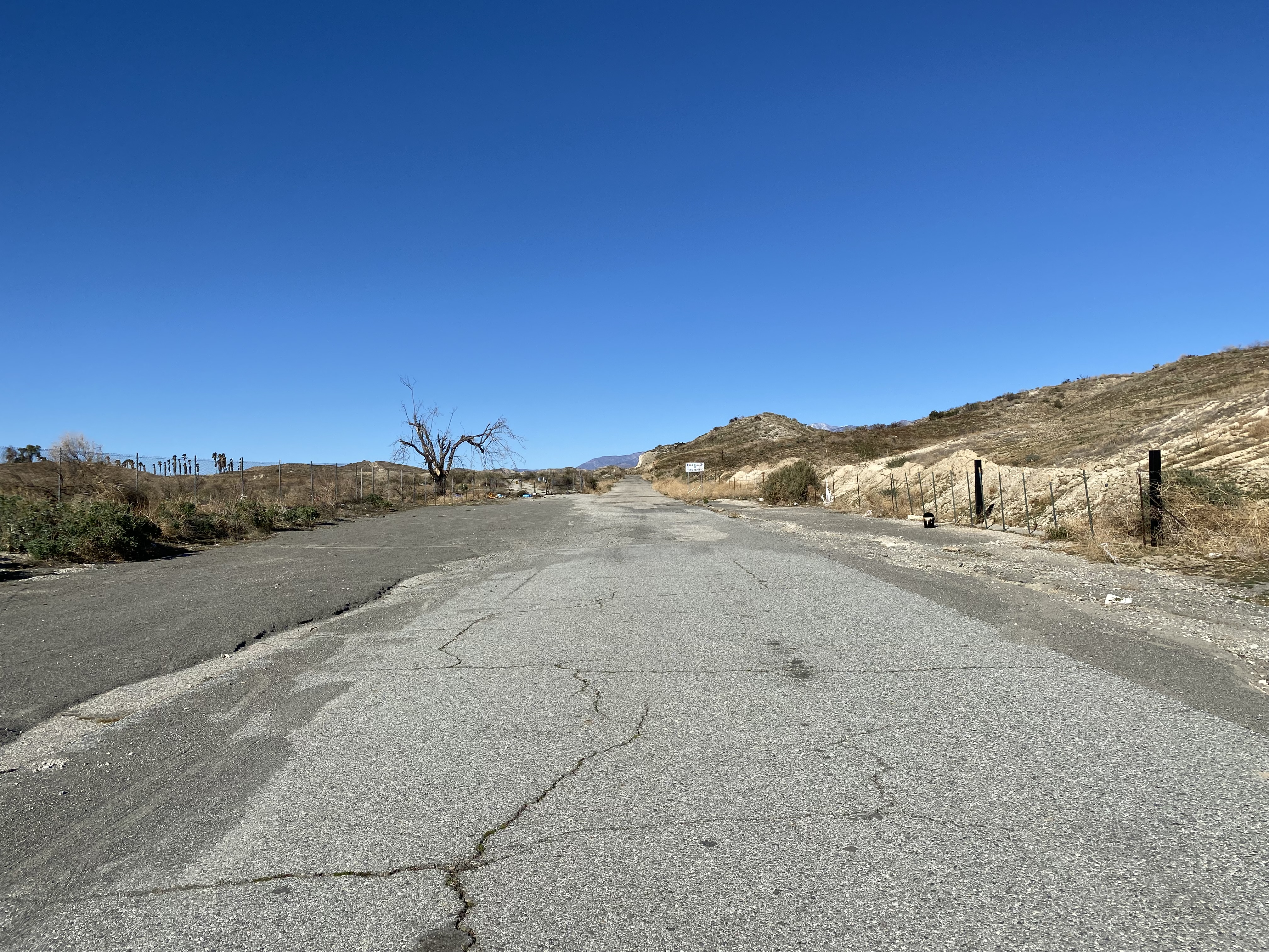
Very little of former US 60/US 70/LRN 19 on Jack Rabbit Trail is accessible as public roadway. A small portion of Jack Rabbit Trail east from Gillman Springs Road (former California State Route 83 and later California State Route 79) can still be accessed by the public.
The modern asphalt on Jack Rabbit Trail gives away several dozen feet from Gillman Springs Road. A couple hundred feet from Gillman Springs Road a sign notifies traffic that former US 60/US 70/LRN 19 is no longer a public through road. It is unclear when Jack Rabbit Trail became abandoned as a through road or is if it can be legitimately hiked on foot towards California State Route 60 near Beaumont.


These photos along Jackrabbit Trail were taken and donated by Vern Kaufman. Older signage on the corridor did not denote a closure nor was there gates present in the past.
Version History
- Originally published on March 21, 2022.
- First updated on April 13, 2025.


Comments