Over the Fourth of July holiday weekend I drove the entirety of California State Route 104 from CA 99 in Galt east to CA 88 in Martell.

CA 104 is a 28 mile east/west highway which traverses sections of Sacramento County and Amador County. Presently CA 104 has an 8 mile segment of un-constructed roadway beyond the east terminus in Martel. CA 104 was one of the original 1934 Signed State Highways which was announced in an August 1934 Department of Public Works Publication as being aligned from Walnut Grove east to Jackson.
1934 Department of Public Works Guide anncouning the Signed State Highways
CA 104 first appears on the 1935 Goshua Highway Map of California being routed between US 99 near Walnut Grove east to CA 49 in Jackson. It appears that CA 104 was likely signed west of Galt on locally the locally maintained roads of; New Hope Road, Thorton Road and Walnut Grove Road to CA 12. This possible alignment of CA 104 isn't fully clear but was common before 1940 for Signed State Highways to be posted on County Maintained roadways.
1935 Goshua Highway Map of California
If CA 104 was signed west of Galt it would have briefly dipped into San Joaquin County. The possibly alignment of New Hope Road, Thorton Road and Walnut Grove is very clearly a major County Highway on the 1935 Division of Highways Map of Sacramento County.
1935 Division of Highways Map of Sacramento County
CA 104 as originally aligned between Walnut Grove and Jackson was signed on Legislative Route Number 34. LRN 34 was first defined in the 1909 First State Highway Bond Act as a highway running from LRN 4 (future US 99) near Arno east to Jackson.
CAhighways.org on LRN 34
The 1935 Division of Highways Map of Sacramento County shows LRN 34/CA 104 close to how it is presently aligned. LRN 34/CA 104 has a slightly different alignment near Clay as shown below.
1935 Sacramento County Highway Map
The east terminus of CA 104/LRN 34 at CA 49 in Jackson is shown on the present route of CA 88 rather than Ridge Road on the 1935 California Division of Highways Map of Amador County.
1935 Amador County Highway Map
The 1940 State Highway Map shows part of CA 104 being consumed by the new CA 88 east of Ione. It is unclear if CA 104 ended at CA 88 on Main Street in downtown Ione or was realigned to CA 16 on LRN 97.
1940 State Highway Map
The 1957 State Highway Map is the first to clearly shown CA 104 routed northeast of Ione to CA 16 on LRN 97. It is likely this is when the shift in CA 104 occurred due to the CA 88 being routed onto a bypass of Ione by 1960. These changes can be seen by comparing 1956 and 1957 State Highway Maps.
1956 State Highway Map
1957 State Highway Map
For reference CA 88 can be seen bypassing Ione to the south on the 1960 State Highway Map.
1960 State Highway Map
During the 1964 State Highway Renumbering CA 124 was assigned over CA 104 northeast of Ione to CA 16. It appears that at minimum CA 104 remained the signed highway in 1964.
1964 State Highway Map
The 1965 State Highway Map clearly shows CA 104 terminating at CA 88 east of downtown Ione
1965 State Highway Map
According to CAhighways.org the legislative definition of CA 104 was extended to West Point in 1970. Interestingly CA 104 was to be apparently signed over part of what was CA 26 to West Point. The first segment of CA 104 on Ridge Road can be seen on the 1975 State Highway Map along with the planned highway eastward to West Point.
CAhighways.org on CA 104
1975 State Highway Map
CA 26 west of West Point is shown on the 1977 State Highway Map as having CA 104 as the legislative route number.
1977 State Highway Map
According to CAhighways.org in 1984 the legislative definition of CA 104 was cut back to Sutter Creek. This effectively dropped the hidden designation of CA 104 over CA 26 between CA 88 and West Point. This change can be seen on the 1986 State Highway Map.
1986 State Highway Map
My approach to CA 104 eastbound was from CA 99 northbound Exit 277 onto Twin Cities Road in Galt. Exit 277 on CA 99 north also accesses Signed County Route E13.


CA 104 east traffic is briefly routed onto Stockton Boulevard where the highway is accessed at roundabout intersection for Twin Cities Road at Post Mile SAC 0.070. CA 104 is signed on east Twin Cities Road whereas CR E13 is signed westward.


CA 104 east continues through the City of Galt on Twin Cities Road. At approximately Post Mile SAC 1.612 CA 104 east exits the City Limits of Galt at Marengo Road.


CA 104 east crosses two sets of tracks and crosses through the rail siding of Herald at Post Mile SAC 3.692.


East of Herald the route of CA 104 begins to enter open country of eastern Sacramento County. In the distance the derelict Rancho Seco Nuclear Generation Station can be seen on the south side of CA 104. Rancho Seco Nuclear Generation Station became fully operational in 1975 but was closed by public vote in 1989. Rancho Seco Nuclear Generation Station was officially decommissioned in 2009 with some of the land becoming a public recreation area. Rancho Seco Nuclear Generation Station is listed on the Post Mile Tool at Post Mile SAC 11.904 whereas Rancho Seco Park is listed at Post Mile SAC 12.943.


East of Rancho Seco Park CA 104 enters the Sierra Foothills which offers vistas of the higher terrain off in the distance.


At Post Mile SAC 17.677 CA 104 east enters Amador County.

At approximately Post Mile AMA 2.21 CA 104 east crosses another set of rails and intersects Michigan Bar Road.


CA 104 east continues onto Michigan Bar Road, crosses Dry Creek and enters the City of Ione at approximately AMA R4.055.


As CA 104 enters Ione there is a historic marker directing traffic to Preston Castle. Preston Castle can be seen from CA 104 and the was constructed in 1890-1894 as a Juvenile Reform Center. Preston Castle remained in service until it was replaced by new buildings on the facility in 1960. The Preston Youth Correctional Facility was closed in June of 2011.

CA 104 east follows Michigan Bar Road and Preston Road into downtown Ione where it meets CA 124 at Post Mile AMA R5.766. As noted above the original alignment of CA 104 continued into downtown Ione whereas the 1956/57-1963 alignment made a left hand turn towards CA 16.


CA 104 east/CA 124 south multiplex on Preston Street and make a left hand turn into downtown Ione on Main Street.


At Post Mile AMA R5.959 CA 124 south splits from CA 104 on Church Street. As noted above the intersection of Main Street and Church Street is where CA 104 likely terminated at CA 88 from 1940 to 1956/57.


More on CA 124 can be found on the blog below.
California State Route 124
Ione is a classic California Gold Rush town and certainly looks the part. Ione is only at 299 feet above sea level and wasn't an active mining community but was mainly used for supplying in addition to stage route access for larger towns in the Sierras. Ione was founded in 1849 and was known by strange names like "Freeze-out" and "Bed Bug" before assuming the current name.


Behind Ione City Hall is a historic monument which has the last steam as to operate on the Amador Central Railroad which is known as Iron Ivan on display. The Amador Central Railroad is a presently derelict standard gauge railroad which operated 11.8 miles between Ione and Martell between 1902 until shuttering in 2004. The Amador Central Railroad was founded as the Ione & Eastern Railroad which was meant to be extended originally as far as Volcano.


CA 104 on Main Street in downtown Ione has a historical marker for D. Stewart Company Store. The D. Stewart Company Store was the first brick building built in Ione in 1856.


At Post Mile AMA R6.011 CA 104 east makes a right hand turn onto Ione Street. CA 104 east traffic is advised the highway takes traffic towards Jackson.

CA 104 east follows Ione Street out of downtown towards CA 88, Jackson is signed as 11 miles away. CA 104 east crosses the Amador Central Railroad exiting Ione and meets CA 88 at approximately Post Mile AMA R8.197.


CA 104 east is silently multiplexed onto CA 88 east.

More on CA 88 can be found on the blog below.
California State Route 88 on the Carson Pass Highway
CA 104 east/CA 88 east multiplex on an uphill grade which has numerous crossings of the Amador Central Railroad.


At approximately Post Mile CA 88 AMA 12.65 the route of CA 104 splits onto Ridge Road. CA 104 would have originally continued on the present route of CA 88 to CA 49 in Martell.


CA 104 east actually terminates between Martell and Sutter Creek at CA 49 on Ridge Road. CA 104 terminates at approximately Post Mile AMA 10.067. The un-built portion of CA 104 was intended to closely follow the alignment of Ridge Road eastward towards CA 88.


As noted above some of current CA 26 between CA 88 and West Point was intended to be part of CA 104. CA 26 can be viewed on the blog below.
California State Route 26

CA 104 is a 28 mile east/west highway which traverses sections of Sacramento County and Amador County. Presently CA 104 has an 8 mile segment of un-constructed roadway beyond the east terminus in Martel. CA 104 was one of the original 1934 Signed State Highways which was announced in an August 1934 Department of Public Works Publication as being aligned from Walnut Grove east to Jackson.
1934 Department of Public Works Guide anncouning the Signed State Highways
CA 104 first appears on the 1935 Goshua Highway Map of California being routed between US 99 near Walnut Grove east to CA 49 in Jackson. It appears that CA 104 was likely signed west of Galt on locally the locally maintained roads of; New Hope Road, Thorton Road and Walnut Grove Road to CA 12. This possible alignment of CA 104 isn't fully clear but was common before 1940 for Signed State Highways to be posted on County Maintained roadways.
1935 Goshua Highway Map of California
If CA 104 was signed west of Galt it would have briefly dipped into San Joaquin County. The possibly alignment of New Hope Road, Thorton Road and Walnut Grove is very clearly a major County Highway on the 1935 Division of Highways Map of Sacramento County.
1935 Division of Highways Map of Sacramento County
CA 104 as originally aligned between Walnut Grove and Jackson was signed on Legislative Route Number 34. LRN 34 was first defined in the 1909 First State Highway Bond Act as a highway running from LRN 4 (future US 99) near Arno east to Jackson.
CAhighways.org on LRN 34
The 1935 Division of Highways Map of Sacramento County shows LRN 34/CA 104 close to how it is presently aligned. LRN 34/CA 104 has a slightly different alignment near Clay as shown below.
1935 Sacramento County Highway Map
The east terminus of CA 104/LRN 34 at CA 49 in Jackson is shown on the present route of CA 88 rather than Ridge Road on the 1935 California Division of Highways Map of Amador County.
1935 Amador County Highway Map
The 1940 State Highway Map shows part of CA 104 being consumed by the new CA 88 east of Ione. It is unclear if CA 104 ended at CA 88 on Main Street in downtown Ione or was realigned to CA 16 on LRN 97.
1940 State Highway Map
The 1957 State Highway Map is the first to clearly shown CA 104 routed northeast of Ione to CA 16 on LRN 97. It is likely this is when the shift in CA 104 occurred due to the CA 88 being routed onto a bypass of Ione by 1960. These changes can be seen by comparing 1956 and 1957 State Highway Maps.
1956 State Highway Map
1957 State Highway Map
For reference CA 88 can be seen bypassing Ione to the south on the 1960 State Highway Map.
1960 State Highway Map
During the 1964 State Highway Renumbering CA 124 was assigned over CA 104 northeast of Ione to CA 16. It appears that at minimum CA 104 remained the signed highway in 1964.
1964 State Highway Map
The 1965 State Highway Map clearly shows CA 104 terminating at CA 88 east of downtown Ione
1965 State Highway Map
According to CAhighways.org the legislative definition of CA 104 was extended to West Point in 1970. Interestingly CA 104 was to be apparently signed over part of what was CA 26 to West Point. The first segment of CA 104 on Ridge Road can be seen on the 1975 State Highway Map along with the planned highway eastward to West Point.
CAhighways.org on CA 104
1975 State Highway Map
CA 26 west of West Point is shown on the 1977 State Highway Map as having CA 104 as the legislative route number.
1977 State Highway Map
According to CAhighways.org in 1984 the legislative definition of CA 104 was cut back to Sutter Creek. This effectively dropped the hidden designation of CA 104 over CA 26 between CA 88 and West Point. This change can be seen on the 1986 State Highway Map.
1986 State Highway Map
My approach to CA 104 eastbound was from CA 99 northbound Exit 277 onto Twin Cities Road in Galt. Exit 277 on CA 99 north also accesses Signed County Route E13.


CA 104 east traffic is briefly routed onto Stockton Boulevard where the highway is accessed at roundabout intersection for Twin Cities Road at Post Mile SAC 0.070. CA 104 is signed on east Twin Cities Road whereas CR E13 is signed westward.


CA 104 east continues through the City of Galt on Twin Cities Road. At approximately Post Mile SAC 1.612 CA 104 east exits the City Limits of Galt at Marengo Road.


CA 104 east crosses two sets of tracks and crosses through the rail siding of Herald at Post Mile SAC 3.692.


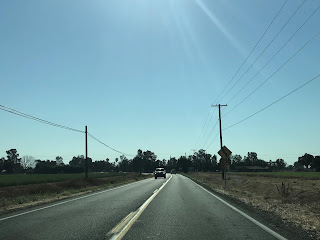
East of Herald the route of CA 104 begins to enter open country of eastern Sacramento County. In the distance the derelict Rancho Seco Nuclear Generation Station can be seen on the south side of CA 104. Rancho Seco Nuclear Generation Station became fully operational in 1975 but was closed by public vote in 1989. Rancho Seco Nuclear Generation Station was officially decommissioned in 2009 with some of the land becoming a public recreation area. Rancho Seco Nuclear Generation Station is listed on the Post Mile Tool at Post Mile SAC 11.904 whereas Rancho Seco Park is listed at Post Mile SAC 12.943.


East of Rancho Seco Park CA 104 enters the Sierra Foothills which offers vistas of the higher terrain off in the distance.


At Post Mile SAC 17.677 CA 104 east enters Amador County.

At approximately Post Mile AMA 2.21 CA 104 east crosses another set of rails and intersects Michigan Bar Road.


CA 104 east continues onto Michigan Bar Road, crosses Dry Creek and enters the City of Ione at approximately AMA R4.055.


As CA 104 enters Ione there is a historic marker directing traffic to Preston Castle. Preston Castle can be seen from CA 104 and the was constructed in 1890-1894 as a Juvenile Reform Center. Preston Castle remained in service until it was replaced by new buildings on the facility in 1960. The Preston Youth Correctional Facility was closed in June of 2011.

CA 104 east follows Michigan Bar Road and Preston Road into downtown Ione where it meets CA 124 at Post Mile AMA R5.766. As noted above the original alignment of CA 104 continued into downtown Ione whereas the 1956/57-1963 alignment made a left hand turn towards CA 16.


CA 104 east/CA 124 south multiplex on Preston Street and make a left hand turn into downtown Ione on Main Street.


At Post Mile AMA R5.959 CA 124 south splits from CA 104 on Church Street. As noted above the intersection of Main Street and Church Street is where CA 104 likely terminated at CA 88 from 1940 to 1956/57.


More on CA 124 can be found on the blog below.
California State Route 124
Ione is a classic California Gold Rush town and certainly looks the part. Ione is only at 299 feet above sea level and wasn't an active mining community but was mainly used for supplying in addition to stage route access for larger towns in the Sierras. Ione was founded in 1849 and was known by strange names like "Freeze-out" and "Bed Bug" before assuming the current name.


Behind Ione City Hall is a historic monument which has the last steam as to operate on the Amador Central Railroad which is known as Iron Ivan on display. The Amador Central Railroad is a presently derelict standard gauge railroad which operated 11.8 miles between Ione and Martell between 1902 until shuttering in 2004. The Amador Central Railroad was founded as the Ione & Eastern Railroad which was meant to be extended originally as far as Volcano.


CA 104 on Main Street in downtown Ione has a historical marker for D. Stewart Company Store. The D. Stewart Company Store was the first brick building built in Ione in 1856.


At Post Mile AMA R6.011 CA 104 east makes a right hand turn onto Ione Street. CA 104 east traffic is advised the highway takes traffic towards Jackson.

CA 104 east follows Ione Street out of downtown towards CA 88, Jackson is signed as 11 miles away. CA 104 east crosses the Amador Central Railroad exiting Ione and meets CA 88 at approximately Post Mile AMA R8.197.


CA 104 east is silently multiplexed onto CA 88 east.

More on CA 88 can be found on the blog below.
California State Route 88 on the Carson Pass Highway
CA 104 east/CA 88 east multiplex on an uphill grade which has numerous crossings of the Amador Central Railroad.


At approximately Post Mile CA 88 AMA 12.65 the route of CA 104 splits onto Ridge Road. CA 104 would have originally continued on the present route of CA 88 to CA 49 in Martell.


CA 104 east actually terminates between Martell and Sutter Creek at CA 49 on Ridge Road. CA 104 terminates at approximately Post Mile AMA 10.067. The un-built portion of CA 104 was intended to closely follow the alignment of Ridge Road eastward towards CA 88.


As noted above some of current CA 26 between CA 88 and West Point was intended to be part of CA 104. CA 26 can be viewed on the blog below.
California State Route 26
Comments