
Maggie and I traveled to Asheville for our one year anniversary. The trip on I-40 was uneventful except for the rain that followed us from Mocksville to Black Mountain. We stopped at Shell's BBQ in Hickory for lunch. it's about a five minute drive north of I-40 Exit 126, but it's worth the detour. (Directions head north from I-40 about 3 miles to Springs Rd NE, turn right, Shell's is about 1/4 mile on the left.) You have to have the Cherry Vanilla Lemon (Sun Drop) Float; it's amazingly good. And the prices are very reasonable.
Sadly, the rain was too hard to get any photos of the old diner and some of the old Pepsi-Cola signs around the restaurant. From Shell's, we got back on I-40 and headed to our hotel in Asheville.
After checking in and relaxing from the drive, we headed out to Pisgah National Forest. We were going to take the Blue Ridge Parkway to US 276 but concerns of possible slides had the parkway closed from NC 191 to US 276. So we took NC 191, NC 280 to US 276 near Brevard.
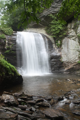
Our first stop was Looking Glass Falls. This was really the first time I focused on long-exposure shots with my tripod.
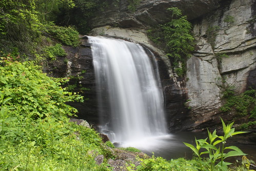
Looking Glass is one of the more popular waterfalls in Western North Carolina, and this rainy Friday afternoon was no exception. A feature of Looking Glass Falls is the ease of access to the falls. The falls can easily be viewed from US 276 as there is a parking area on the northbound side of the road. From there, it's a very short walk to the main viewing platform. If you want a closer look, all you need to do is head down the staircase.
Just up the road is Sliding Rock. Sliding Rock may be more popular than Looking Glass Falls. Sliding Rock is a 60 foot natural waterslide; and during the summer months, an extremely popular spot to cool off. During the summer season (Memorial Day through Labor Day), Sliding Rock is manned by National Forest Service staff (including lifeguards) and there is a minimal $1 per person entry fee.
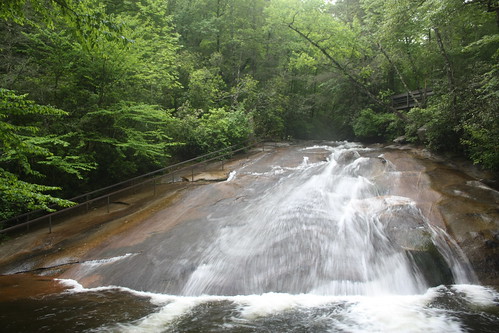
As tempting as it was to slide down the rock into the 7' pool at the bottom, the cold water and rainy conditions wasn't worth the risk. Oh well, there's always another trip during the summer!
For the whole photo set from both Looking Glass and Sliding Rock head here. Day 2 was a visit to the famous Biltmore Estate, and I can't wait to share that!
Sadly, the rain was too hard to get any photos of the old diner and some of the old Pepsi-Cola signs around the restaurant. From Shell's, we got back on I-40 and headed to our hotel in Asheville.
After checking in and relaxing from the drive, we headed out to Pisgah National Forest. We were going to take the Blue Ridge Parkway to US 276 but concerns of possible slides had the parkway closed from NC 191 to US 276. So we took NC 191, NC 280 to US 276 near Brevard.
Our first stop was Looking Glass Falls. This was really the first time I focused on long-exposure shots with my tripod.
Looking Glass is one of the more popular waterfalls in Western North Carolina, and this rainy Friday afternoon was no exception. A feature of Looking Glass Falls is the ease of access to the falls. The falls can easily be viewed from US 276 as there is a parking area on the northbound side of the road. From there, it's a very short walk to the main viewing platform. If you want a closer look, all you need to do is head down the staircase.
Just up the road is Sliding Rock. Sliding Rock may be more popular than Looking Glass Falls. Sliding Rock is a 60 foot natural waterslide; and during the summer months, an extremely popular spot to cool off. During the summer season (Memorial Day through Labor Day), Sliding Rock is manned by National Forest Service staff (including lifeguards) and there is a minimal $1 per person entry fee.
As tempting as it was to slide down the rock into the 7' pool at the bottom, the cold water and rainy conditions wasn't worth the risk. Oh well, there's always another trip during the summer!
For the whole photo set from both Looking Glass and Sliding Rock head here. Day 2 was a visit to the famous Biltmore Estate, and I can't wait to share that!

Comments