
Asheville Wayfinding Signs

Usually wayfinding signs for towns and cities have a little bit of flare to them - something that is unique to or is specific to the city.  The City of Asheville takes a different approach to theirs.

IMG_6466

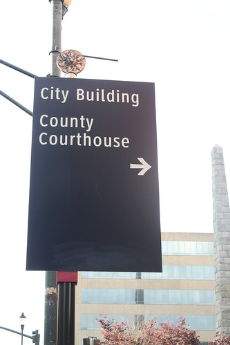
This sign is rather bland.  Black with white lettering - yes a nice ornamental top, but other than that nothing much to it.  However...

IMG_6465

...the back of the wayfinding signs is where the real design is showcased.  To the right of the pole, a stained glass window like design with numerous colors.  To the left, a quote from various notables like Carl Sandburg, Thomas Wolfe, or John Muir, just to name a few.  This certainly adds a lot more interest to the sign than directing you to various landmarks.

Asheville also has smaller more pedestrian friendly wayfinding signs - similar to those old crossroad signs with arrows pointing in all directions - at numerous street corners throughout downtown.  Like this one in Pack Place:

IMG_6463

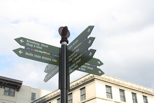
Asheville certainly found a way to put their own unique personality in their wayfinding signs.

Comments

Creative and well-designed way-finding signage.

Popular posts from this blog

Petroleum Club Road (former California State Route 33 and US Route 399 past the Lakeview Gusher)

Petroleum Club Road is an approximately 5.3-mile rural highway located in the Sunset Oil Field of western Kern County.  This corridor was constructed as a frontage road of the Sunset Railroad and would be the site of the Lakeview Gusher in 1910.  Petroleum Club Road was the original alignment of California State Route 33 and US Route 399 between 1934-1938.  In 1938 the West Side Highway was constructed west of Lakeview Gusher and still serves as the current alignment of California State Route 33.   Part 1; the history of Petroleum Club Road Petroleum Club Road is the original highway which linked the oil communities of Maricopa and Taft.  Both cities were developed around the early boom of the Sunset Oil Field.  The early Sunset Oil Field can be seen centered along Cienega Canyon Road southwest of Buena Vista Lake in Township 11 North, Range 23 West on the 1898 Kern County Surveyors map .  In 1901 Post Office Service would be established at the Su...

Did Caltrans just kill the G26 cutout US Route shields?

The US Route System was formally created by the American Association of State Highway Officials during November 1926.  Through the history of the system the only state to which has elected to maintain cutout US Route shields has been California.  The G26 series cutout US Route shields have become a favorite in the road enthusiast hobby and are generally considered to be much more visually pleasing than the standard Federal Highway Administration variant.  However, the G26 shield series appears to have been killed off on January 18, 2026, when Caltrans updated their Manual of Uniform Traffic Control Devices.  This blog will examine the history of the US Route shield specifications in California and what is happening with the 2026 changes.  The blog cover photo is facing towards the terminus of California State Route 136 and at a G26-2 specification US Route 395 shield.  In the background Mount Whitney can be seen in the Sierra Nevada range.   ...

Rosecrans Avenue Overpass

In 1995 the Atchison, Topeka and Santa Fe Railway installed the modern Rosecrans Avenue Overpass.  The current 300 feet long Polygonal Warren Through truss is the third railroad overpass structure to have been built at the intersection of Rosecrans Avenue and Aviation Boulevard.  The modern structure was proceeded by a 164.1-foot-long span built in 1964 which was a replacement for the original 1924-era overpass.  An overview of the Rosecrans Avenue Overpass The intersection of Rosecrans Avenue and Aviation Boulevard (originally Redondo Road) lies at the boundaries of three cities.  The city of Hawthorne occupies the lands east of the intersection, El Segundo occupies the northwest corner and whereas Manhattan Beach is located at the southeast corner.   Since 1924 the intersection Rosecrans Avenue and Redondo Road would be the location of a railroad overpass structure.  The original overpass was a 100-foot-long pony truss/plate girder design built by t...