
Just another Sunday Drive

The past six weeks have been the closest you can get to having "cabin fever" in North Carolina.  With the exception of four days, the weather since New Years has been rather dismal, cold, dreary, and wet.  So on Sunday with an errand to run, I made it a quick three hour mini trip into Franklin and Warren Counties.

My Route: NC 98, US 401, NC 561, NC 43, NC 58, US 401, NC 98, US 1, I-540.

For the photo set head over to flickr.

I picked up a few new crossroads for that project, and I only took under two dozen photos.  But sometimes, there's a photo or two that makes a trip like Sunday's worthwhile.  Along NC 43 in the tiny community of Arcola is an old abandoned general store.

G.W. Davis Corner Store - Arcola, NC

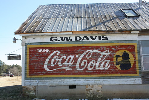
G.W. Davis General Store, which as I found out from a few locals that were at Arcola Grocery across the corner, closed about 15 or so years ago.  It was a true country store - there was a post office, grocery, hardware store, and even clothing store all there.  And as the gentleman from Arcola said, "Most likely they still have most of those goods still locked up inside."

Former G.W. Davis General Store Coca-Cola Billboard - (Black and White)

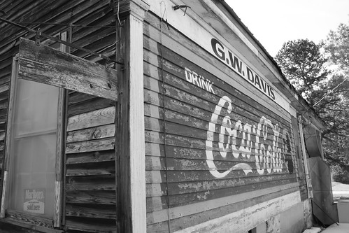
Little finds like G.W. Davis General Store is just a reminder why I do enjoy this hobby.

Comments

Popular posts from this blog

Crescent City Connection (New Orleans, LA)

The Crescent City Connection is a massive dual-span steel truss bridge that spans the lower Mississippi River at downtown New Orleans, about 95 river miles upstream from the mouth of the great river at the Head of Passes Light. If counted as a single bi-directional highway bridge, the parallel spans combine to form the single busiest bridge on the Mississippi River and its importance as a linchpin in the region’s transportation network cannot be overstated. While there have been various schemes over the years to construct bridges downriver from Algiers Point, this bridge has been the southernmost bridge on the Mississippi River since its initial construction in the 1950s. The years immediately following the end of World War II were a transformational period in the history of New Orleans. Already one of the great economic and cultural centers of the American Deep South, it was recognized at this time that major changes and improvements to the city’s transportation infrastructure would b...

Old US Route 99 through Tipton, Tulare, and Tagus Ranch

This summer I had a look into the alignment history of US Route 99 through the Tulare County communities of Tipton, Tulare, and Tagus Ranch.  While this slab below might seem like much it is one of the few remaining reminders of how US Route 99 was during the 1920s in Tulare County. This blog is part of the larger Gribblenation US Route 99 Page.  For more information pertaining to the other various segments of US Route 99 and it's three-digit child routes check out the link the below. Gribblenation US Route 99 Page Part 1; the history of US Route 99 in Tipton, Tulare, and Tagus Ranch Tipton and Tulare were both founded in 1872 as sidings of the Southern Pacific Railroad.  The Southern Pacific Railroad laid the groundwork for development of southern San Joaquin Valley.  Previous to the Southern Pacific Railroad travel via wagon or foot in Central California tended to avoid San Joaquin Valley in favor of the Stockton-Los Angeles Road.  The Stockton Los Ange...

Former US Route 101 and California State Route 41 through Paso Robles

Paso Robles is a city located on the Salinas River of San Luis Obispo County, California.  As originally configured the surface alignments of US Route 101 and California State Route 41 converged in downtown Paso Robles.  US Route 101 originally was aligned through Paso Robles via Spring Street.  California State Route 41 entered the City of Paso Robles via Union Road and 13th Street where it intersected US Route 101 at Spring Street.  US Route 101 and California State Route 41 departed Paso Robles southbound via a multiplex which split near Templeton.   Pictured above is the cover of the September/October 1957 California Highways & Public Works which features construction of the Paso Robles Bypass.  Pictured below is the 1935 Division of Highways Map of San Luis Obispo County which depicts US Route 101 and California State Route 41 intersecting in downtown Paso Robles.   Part 1; the history of US Route 101 and California State Route 41 i...