
Hassenplug Covered Bridge - Mifflinburg, Pennsylvania


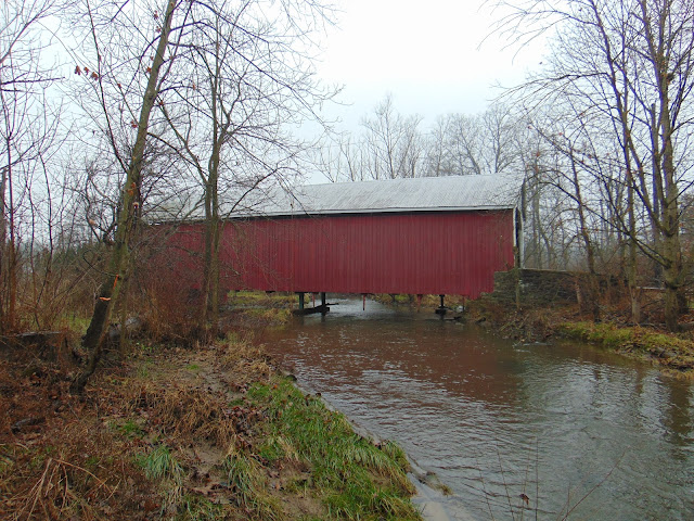
The Hassenplug Covered Bridge is a 70 foot long covered bridge located over the Buffalo Creek in Mifflinburg, Pennsylvania. The bridge was named for the Hassenplug family, who had a home nearby to the bridge. Built in 1825, it is believed to be one of the oldest remaining historic covered bridges in the United States, with only the Hyde Hall Covered Bridge in Upstate New York possibly being older as it was built the same year. The covered bridge was built with a Burr arch truss design.

The covered bridge was restored or modernized in 1959. During the restoration process, the wooden deck was replaced with steel grating and a pier was added to allow for heavier vehicles to cross. The bridge is still open to traffic today on North Fourth Street in Mifflinburg, allowing for a weight limit of 6 tons. There is a small parking area at the south end of the bridge, which is also shared by the one mile long Koons Trail.


How to Get There:


Sources and Links:
Bridgehunter.com - Hassenplug Covered Bridge 38-60-03
Valley Girl Views - The Hassenplug Covered Bridge
PA Bucket List - Exploring the Hassenplug Covered Bridge in Union County


Update Log:
February 24, 2022 - Crossposted to Quintessential Pennsylvania - https://quintessentialpa.blogspot.com/2022/02/hassenplug-covered-bridge.html

Comments

Popular posts from this blog

US Route 62 and US Route 180 in the Guadalupe Mountains

US Route 62/US Route 180 between El Paso, Texas and Carlsbad, New Mexico passes through the Guadalupe Mountains.  The Guadalupe Mountains comprise the highest peaks of Texas which are largely protected as part Guadalupe Mountains National Park.  The automotive highway through the Guadalupe Mountains was constructed in the late 1920s as part of Texas State Road 54.  US Route 62 was extended from Carlsbad through the Guadalupe Mountains to El Paso during 1932.  US Route 62 was joined in the Guadalupe Mountains by US Route 180 in 1943.  The Guadalupe Mountains comprise a portion of the 130 mile "No Services" zone on US Route 62/US Route 180 between El Paso-Carlsbad. Part 1; the history of US Route 62 and US Route 180 in the Guadalupe Mountains The Guadalupe Mountains lie within the states of Texas and New Mexico.  The Guadalupe Mountains essentially is a southern extension of the larger Rocky Mountains.  The Guadalupe Mountains is the highest range in Texas with the peak elevati

Former California State Route 215

  California State Route 215 was a short-lived state highway which existed in the Los Angeles Metropolitain area after the 1964 State Highway Renumbering.  California State Route 215 was aligned from US Route 60 at 5th Street in Pomona north to US Route 66 near Claremont via Garey Avenue.  California State Route 215 came to be after California State Route 71 was bisected in Pomona due to relinquishment of a portion of Garey Avenue due to the opening of a portion of the Corona Freeway (now Chino Valley Freeway) during 1958.  California State Route 215 was deleted by the Legislature during 1965. The history of California State Route 215 The initial segment of what was to become California State Route 215 was added to the State Highway System as part of the 1909 First State Highway Bond Act.  The First State Highway Bond Act defined what would become  Legislative Route Number 19  (LRN 19) as running from Claremont to Riverside.  The segment of LRN 19 between Claremont and Pomona would in

Paper Highways; unbuilt California State Route 100 in Santa Cruz

This edition of Paper Highways examines the unbuilt California State Route 100 in Santa Cruz. The History of Unbuilt California State Route 100 The route that became CA 100 was added to the State Inventory in 1959 as part of the Freeway & Expressway System as Legislative Route 287 .  According to CAhighways.org the initial definition of LRN 287 had it begin at LRN 5 (CA 17) and was defined over the below alignment to LRN 56 (CA 1) through downtown Santa Cruz. -  Ocean Street -  2nd Street -  Chestnut Street For context the above alignment would required tearing down a large part of the densely populated Santa Cruz.  A modern Google imagine immediately reveals how crazy an alignment following Ocean Street, 2nd Street, and Chestnut Street would have been. LRN 287 first appears on the 1960 Division of Highways State Map . In 1961 the definition of LRN 287 was generalized to; from LRN 5 via the beach area in Santa Cruz to LRN 56 west of the San Lorenzo River.