
Sanderson Covered Bridge - Brandon, Vermont


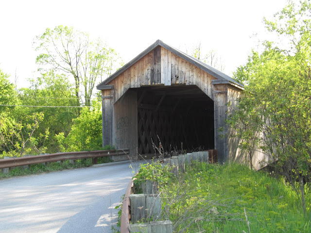
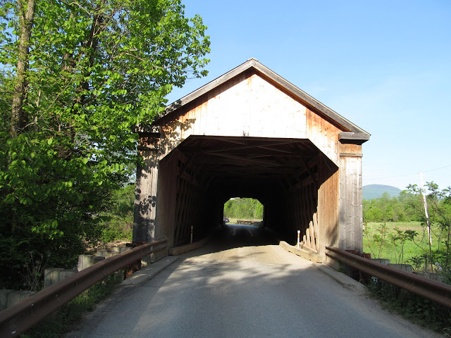
The Sanderson Covered Bridge is located on Pearl Street in Brandon, Vermont and is the second covered bridge to be located at this location. The bridge was named for the Sanderson family, who has been in ownership of a nearby family farm since 1825. The current covered bridge was built in a Town lattice truss design by builders Blow and Cote of Morrisville, Vermont in 2003 at a cost of $830,000. The modern day bridge spans 121 feet over the Otter Creek and is the only covered bridge that remains within the Town of Brandon.

The original covered bridge was built in 1838. While it has been rumored by some historians that famed covered bridge builder Nicholas Powers built the first Sanderson Covered Bridge, the true builder of the bridge is unknown. In 1989, the bridge had been closed to traffic and a temporary steel bridge was placed alongside the covered bridge. Due to the high cost of an archeological survey that was required before a permanent bridge could be constructed, it was decided to dismantle the original covered bridge and rebuild the bridge using new materials. However, the new bridge does contain a few truss lattice members, chord members and roof beams that were salvaged from the original bridge.

Today, the Sanderson Covered Bridge takes up a quiet slice of countryside just southwest of the village center of Brandon. Fans of the opera will find the Barn Opera located near the covered bridge. Others will find the covered bridge is part of a nice drive through rural portions of Rutland County, Vermont.


How to Get There:


Sources and Links:
Vermont Covered Bridge Society - Sanderson Covered Bridge (Replacement)
Brandon Area Chamber of Commerce - Covered Bridge Tour Southern Route
Bridgehunter.com - Sanderson Covered Bridge 45-11-02 #2
The Travels of Tug 44 - Sanderson Covered Bridge
Vermont Covered Bridge Society - Sanderson Covered Bridge Repairs - 2002/2003

Comments

Popular posts from this blog

The 1915-era Teilman Bridge (the only known Concrete Pony Truss Bridge in California)

The Teilman Bridge is a semi-abandoned structure over Fresno Slough west of Burrell siding near the intersection of Elkhorn Avenue and Elkhorn Grade.  This structure is the only known Concrete Pony Truss Bridge constructed in California and was designed by Ingvart Teilman.  Teilman's Bridge would open in late 1915 when the Elkhorn Grade was the primary road between Fresno and Coalinga.  The structure would be replaced in 1991 but was left standing as it carries pipelines over Fresno Slough.  Part 1; the history of the Teilman Bridge In the early Twentieth Century the most direct highway between Fresno and Coalinga followed the Elkhorn Grade.  The Elkhorn Grade began at Fresno Slough a short distance west of Burrell siding.  From Fresno Slough the Elkhorn Grade followed a generally southwestern course through San Joaquin Valley into the Kettleman Hills towards Coalinga.   The Elkhorn Grade can be seen on the  1914 C.F. Weber map of Fresno Coun...

The Dummy Lights of New York

  A relic of the early days of motoring, dummy lights were traffic lights  that  were  placed  in the middle of a street intersection. In those early days, traffic shuffled through busy intersections with the help of a police officer who stood on top of a pedestal. As technology improved and electric traffic signals became commonplace, they were also  originally  positioned on a platform at the center of the intersection. Those traffic signals became known as  " dummy lights "  and were common until  traffic lights were moved  onto wires and poles that crossed above the intersection.  In New York State, only a handful of these dummy lights exist. The dummy lights  are found  in the Hudson Valley towns of Beacon and Croton-on-Hudson, plus there is an ongoing tug of war in Canajoharie in the Mohawk Valley, where their dummy light has been knocked down and replaced a few times. The dummy light in Canajoharie is currently...

Prunedale Road (Monterey County)

Prunedale Road is a short 2.6-mile-long frontage corridor of US Route 101 in the namesake Monterey County community of Prunedale.  Prior to 1932 US Route 101 bypassed Prunedale in favor of the San Juan Grade to the east.  Prunedale Road along with nearby Moro Road served as an alternative connecting highway between Salinas and San Juan Bautista.  Following the realignment of US Route 101 onto the Prunedale Cutoff the former through route along Prunedale Road would be rendered as a western frontage.   Part 1; the history of Prunedale Road Prunedale Road is located in and is named after the Monterey County community of Prunedale.  Said community was founded near the junction of San Migeul Canyon, Langley Canyon and Echo Valley.  Watsonville settler Charles Langley (namesake of Langley Canyon) was one of the prominent early community settlers.  The Prunedale Post Office would open for the first time in 1894 but would close by 1908.  Early agricu...