Los Alamitos Traffic Circle is located in the city of Long Beach and presently a component of California State Route 1. Los Alamitos Traffic Circle was originally completed during 1934 and was originally designated as California State Route 3. Los Alamitos Traffic Circle would part of become US Route 101 Alternate in 1935, US Route 91 during 1947 and even for a brief time California State Route 18. California State Route 1 was designated as through Los Alamitos Circle during the 1964 State Highway Renumbering. Pictured as the blog cover photo is Los Alamitos Traffic Circle in 1942 when it was part of US Route 101 Alternate.
Part 1; the history of Los Alamitos Traffic Circle
What is now California State Route 1 (CA 1) from San Juan Capistrano (originally Serra) to El Rio was defined as Legislative Route Number 60 (LRN 60) as part of the 1919 Third State Highway Bond Act. At the time the State of California could not maintain highway mileage in cities which included Long Beach.
During 1933 the legislative barriers preventing the Division of Highways from maintaining urban highways was removed. Subsequently, construction of Los Alamitos Traffic Circle became an active Division of Highways project. Los Alamitos Traffic Circle opened during 1934 and likely is the second such design constructed in California (the first being the Belmont Traffic Circle of US Route 99 in Fresno).
The initial run of Sign State Routes were announced in the August 1934 California Highways & Public Works. CA 3 followed the entirety of LRN 60 which by proxy took it through Los Alamitos Traffic Circle in Long Beach. CA 3 originally carried the following definition:
A map depicting CA 3/LRN 60 passing through Long Beach can be seen in the August 1934 California Highways & Public Works. Los Alamitos Traffic Circle is shown to be the southern terminus of CA 19/LRN 168.
Los Alamitos Traffic Circle can be seen under State Maintenance on the 1935 Division of Highways Map of Los Angeles County-City of Los Angeles. Los Alamitos Traffic Circle was located at the junction of State Street, Bennett Avenue and Hathaway Avenue.
The completed Los Alamitos Circle can be seen facing westward towards State Street in the undated photo (post 1942) below. Los Alamitos Traffic Circle originally only had what is now the inner circle. The inner circle transitioned the implied connection of CA 3/LRN 60 from Hathaway Avenue to State Street.
On July 20th, 1935, the California State Highway Engineer notified the American Association of State Highway Officials (AASHO) Executive Secretary that US Route 101 Alternate (US 101A) had been designated over the entirety of CA 3/LRN 60. This measure put Los Alamitos Traffic Circle on the alignment of US 101A.
US 101A can be seen passing through Los Alamitos Traffic Circle on the
1938 Division of Highways Map City Insert. Notably CA 19/LRN 168 can be seen accessing Los Alamitos Traffic Circle via what was now named Lakewood Boulevard (renamed from Bennet Avenue).
The
June 1942 California Highways & Public Works announced Los Alamitos Traffic Circle had been expanded and widened. The article stub notes Los Alamitos Traffic Circle was constructed with the concept of having six highways enter it but only three were constructed. Los Alamitos Traffic Circle had been expanded with an outer ring which had been built by the city of Long Beach and Los Angeles County. The original inner Los Alamitos Traffic Circle was expanded to increase capacity on US 101A/LRN 60. Completion of the upgrades to Los Alamitos Traffic Circle was completed on April 20th, 1942.
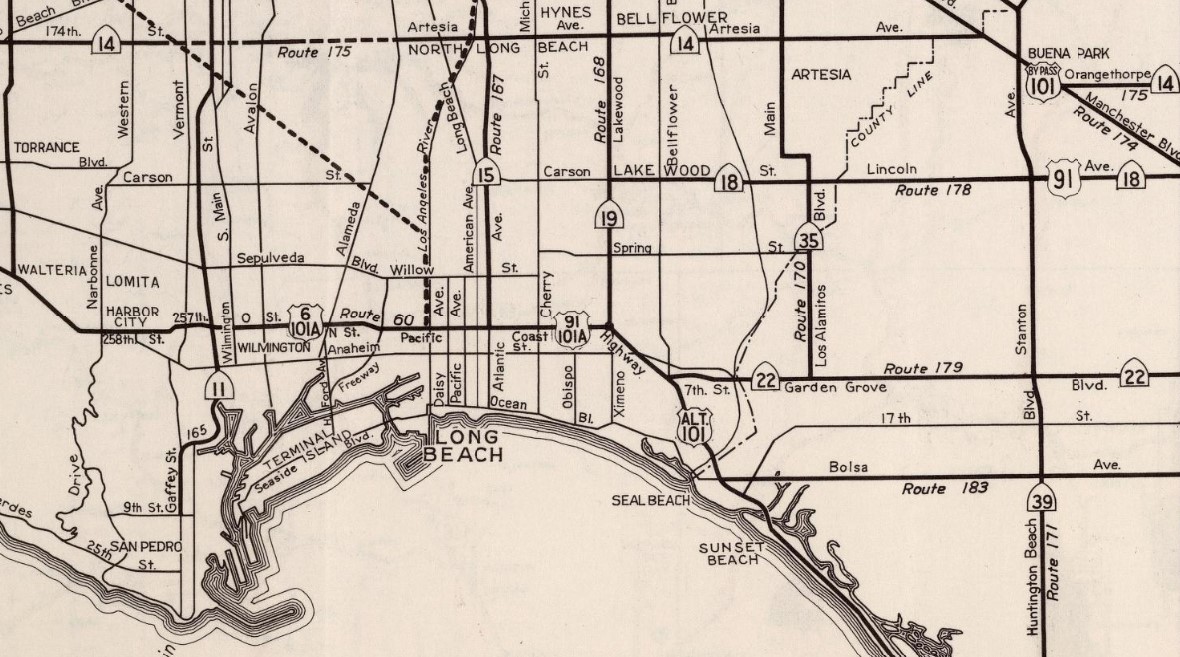
On July 1st, 1947, the AASHO Executive Secretary notified the California State Highway Engineer that California's request to extend US 91 from Barstow to Long Beach had been approved. The extension of US 91 to Long Beach brought it into the city via multiplex of CA 19/LRN 168 to Los Alamitos Traffic Circle and west on US 101A/LRN 60 on Pacific Coast Highway.
US 91 can be seen multiplexing US 101A through Los Alamitos Traffic Circle on the
1948 Division of Highways Map City Insert.
Los Alamitos Traffic Circle can be seen below in a photo dated to 1956.
The
1957 Division of Highways Map displays CA 18 being extended south of Carson Street via US Route 91/CA 19/LRN 168 to Los Alamitos Traffic Circle and westward via US Route 101A/US Route 91/LRN 60 to Long Beach. It is unclear why CA 18 was extended via the already existing multiplex of US Route 91/CA 19 on LRN 168.
The
1962 Division of Highways Map displays CA 18 truncated from Long Beach to San Bernardino. The truncation of CA 18 removed it from Los Alamitos Circle, a lengthy multiplex of US Route 91 and CA 19 on LRN 168/Lakewood Boulevard.
As part of the 1964 State Highway Renumbering US 91 was truncated to Barstow and US 101A was replaced with an extended CA 1 in the El Rio-San Juan Bautista corridor. The
1964 Division of Highways Map displays CA 1 passing through Los Alamitos Traffic Circle.
In 1993 Caltrans reconfigured Los Alamitos Traffic Circle to modern roundabout conventions. CA 19 was relinquished in the city of Long Beach via AB 2132 Chapter 877 which was signed on September 26th, 1998. Despite CA 19 being truncated out of Long Beach the highway is still signed approaching Los Alamitos Traffic Circle. The
2005 Caltrans Map notably does not display CA 19 reaching Los Alamitos Traffic Circle pursuant to the 1998 relinquishment in Long Beach.
Part 2; a drive through Los Alamitos Traffic Circle
The illustrated approach to Los Alamitos Traffic Circle begins from the western terminus of CA 22/7th Street via northbound turn onto CA 1/Pacific Coast Highway in Long Beach.
CA 1 northbound follows Pacific Coast Highway through Long Beach. Approaching the outer circle of Los Alamitos Traffic Circle a diagram depicting what highways can be accessed in the inner circle can be observed. As noted above CA 19 is still displayed as being aligned on Lakewood Boulevard.
CA 1 northbound passes outer Los Alamitos Traffic Circle and dips into the inner circle. The first street accessed within inner Los Alamitos Traffic Circle is Los Coyotes Diagonal.
Inner Los Alamitos Traffic Circle next accesses Lakewood Boulevard which is still signed as CA 19. US 101A northbound would have picked up US 91 southbound at CA 19/Lakewood Boulevard.
Inner Los Alamitos Traffic Circle next accesses the branching point of CA 1 northbound via Pacific Coast Highway. US 101A northbound and US 91 southbound would have departed Los Alamitos Traffic Circle via what is now the northbound CA 1 exit.
Completing the loop of inner Los Alamitos Traffic Circle takes traffic back to southbound CA 1 via Pacific Coast Highway.






Comments