
Maple Street Covered Bridge - Fairfax, Vermont


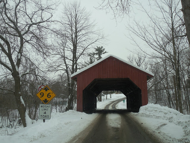
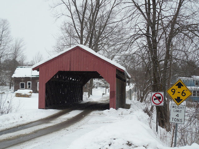
Also known as the Fairfax Covered Bridge, the Maple Street Covered Bridge spans 57 feet across the Mill Brook along Maple Street in Fairfax, Vermont. The bridge was initially built in 1865 by Kingsbury and Stone, utilizing a Town Lattice truss design for the covered bridge. This covered bridge appears wider than many covered bridges in Vermont, owing to its 17 foot wide deck width and low clearance.

The Maple Street Covered Bridge was almost lost due to flooding in early November 1927, following a very wet October in northern New England. During the late morning and early afternoon on November 3, 1927, rainfall records were set for both hourly density and single storm totals. It was estimated that a cubic mile of water had been lifted off the Atlantic Ocean and deposited on Vermont as a result of a dissipating tropical storm. Four of the five covered bridges that were located in Fairfax, Vermont were destroyed, with the only bridge being saved was the covered bridge on Maple Street. That bridge was taken off its abutments and drifted downstream, where it rested against some trees. After the bridge was brought back to its abutments after the flood, it was thought by some people that the bridge was reinstalled with its original east end facing west, which makes it seem to lean. Perhaps the idea was to get the bridge operating again quickly, given that all of the other covered bridges in town had been destroyed.

The covered bridge was rehabilitated in 1990 and 2002 by Jan Lewandowski of Restoration and Traditional Building, who has worked on several covered bridges across Vermont. Repairs were made to the upper chord, truss web, king posts, roofers, and rafters in the 2002 restoration, which was deemed necessary after a truck driver caused damage to the bridge. With that restoration, the bridge's lean was also repaired. Today, you can find the Maple Street Covered Bridge in an idyllic setting that meshes well within the village center of Fairfax.


How to Get There:


Sources and Links:
Bridgehunter.com - Fairfax Covered Bridge 45-06-02
Vermont Covered Bridge Society - The Maple Street Covered Bridge
VTGrandpa.com - Fairfax, Vermont and the Flood of November 1927

Comments

Popular posts from this blog

Tulare Lake returns

During the winter of 2023 California experienced one of the wettest seasons in recent decades.  Enough snow and water were deposited into the Sierra Nevada Mountains that the runoff was enough to partially reform Tulare Lake within San Joaquin Valley.  Tulare Lake was once the largest lake west of the Mississippi River by surface area.  Tulare Lake has been largely dried for the past century due to irrigation divisions and upstream impoundments.  This blog will examine the history of Tulare Lake and its recent return.  Pictured as the blog cover is Tulare Lake from 19th Avenue in Kings County during early May 2023.  Tulare Lake can be seen near its maximum extent below on the 1876 P.Y. Baker Map of Tulare County .   Part 1; the history of Tulare Lake Tulare Lake is the largest remnant of Lake Corcoran.  Lake Corcoran once covered much of the entire Central Valley due to being it being located at a in natural low point from where mountain run-off would accumulate.  Lake Corcoran is thou

Former US Route 101 through Sargent

  Sargent is a ghost town and siding of the Southern Pacific Railroad located in southern Santa Clara County.  The original alignment of US Route 101 was aligned through Sargent via what is now known as Old Monterey Road.  Sargent was bypassed gradually due to shifts of the alignment of US Route 101 which occurred during 1941 and 1950.  Pictured as the blog cover is a view on Old Monterey Road which is now no longer accessible to the general public.  Below is a scan of the 1935 Division of Highways Map of Santa Clara County which depicts the original alignment US Route 101 through Sargent.   Part 1; the history of US Route 101 in Sargent Sargent lies on land which was once part of Rancho Juristac.  During 1856 James P. Sargent purchased Rancho Juristac and plotted what was known as Sargent Ranch.  By 1869 the Southern Pacific Railroad coast line reached the relocated town site of Gilroy.  The Southern Pacific Railroad coast line would be constructed through Chittenden Pass by 1871 whic

California State Route 60/Former US Route 60/70 through the Moreno Valley Badlands west to Riverside

This past month I drove California State Route 60 through the Moreno Valley Badlands westward towards the City of Riverside.  CA 60 through the Moreno Valley Badlands was once part of the corridors of US Route 60 and US Route 70. The present route of CA 60 is a 70 mile (76 counting multiplex) slice of former US 60 between downtown Los Angeles east to I-10 near Beaumont.  The vast majority of CA 60 aside from a small section in the Moreno Valley Badlands is presently a freeway grade. For me CA 60 holds some personal history as it was the route I used most frequently accessing work sites in the Inland Empire circa 2011-2013.  Despite what many others probably would say I always really enjoyed the Moreno Valley Badlands portion of CA 60.  Considering I frequently worked on US 60 through Arizona and New Mexico the route holds even more appeal.  I even have a CA 60 shield hanging up in my garage. Part 1; History of Roadways in the Moreno Valley Badlands CA 60 between B