Upon descending back to US Route 24 from the summit of Pikes Peak I
turned west. My next destination was located at Florissant Fossil Beds
National Monument.

This article serves the 27th entry in the 2016 Summer Mountain Trip Series. Part 26 covered a trek up to the summit of Pikes Peak via the Pikes Peak Highway.
2016 Summer Mountain Trip Part 26; the Pikes Peak Highway
Florissant Fossil Beds National Monument is located off of Teller County Route 1 south of the namesake Florissant and US Route 24. Florissant Fossil Beds National Monument was authorized in August 1969 and protects the Florissant Formation. The Florissant Formation dates back 34 million years to the Eocene era when the area was thought to be covered by a large lake. The fossils located at the Florissant Formation are thought to have been covered by debris the nearby extinct Thirtynine Mile Volcanic Field. The Florissant Formation is most known for it's Petrified Redwood Forest which was quite the sight to see being from California.

Given a large thunderstorm was approaching I didn't have much time for hiking at the Florissant Formation. A quick hike through the Ponderosa Loop revealed some large petrified Redwood stumps. The Redwoods in the Florissant Formation are similar to modern Redwood Sequoias but likely only grew to a height of about 200 feet. Most of the Redwoods at the Florissant Formation are thought to have been 500-700 years old when the Thirtynine Mile Volcanic Field covered them.


I barely had time before the thunderstorm rolled in to run the mile long Petrified Forest Loop Trail.


Upon returning to my car I drove north on Teller County Route 1 to Florissant. My next destination was on US Route 24 about 93 miles away in Leadville.

The next entry in the 2016 Summer Mountain Trip Series can be found below:
2016 Summer Mountain Trip Part 28; US Route 24 through Leadville

This article serves the 27th entry in the 2016 Summer Mountain Trip Series. Part 26 covered a trek up to the summit of Pikes Peak via the Pikes Peak Highway.
2016 Summer Mountain Trip Part 26; the Pikes Peak Highway
Florissant Fossil Beds National Monument is located off of Teller County Route 1 south of the namesake Florissant and US Route 24. Florissant Fossil Beds National Monument was authorized in August 1969 and protects the Florissant Formation. The Florissant Formation dates back 34 million years to the Eocene era when the area was thought to be covered by a large lake. The fossils located at the Florissant Formation are thought to have been covered by debris the nearby extinct Thirtynine Mile Volcanic Field. The Florissant Formation is most known for it's Petrified Redwood Forest which was quite the sight to see being from California.
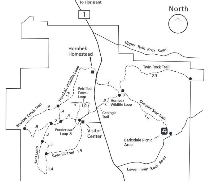
Given a large thunderstorm was approaching I didn't have much time for hiking at the Florissant Formation. A quick hike through the Ponderosa Loop revealed some large petrified Redwood stumps. The Redwoods in the Florissant Formation are similar to modern Redwood Sequoias but likely only grew to a height of about 200 feet. Most of the Redwoods at the Florissant Formation are thought to have been 500-700 years old when the Thirtynine Mile Volcanic Field covered them.


I barely had time before the thunderstorm rolled in to run the mile long Petrified Forest Loop Trail.


Upon returning to my car I drove north on Teller County Route 1 to Florissant. My next destination was on US Route 24 about 93 miles away in Leadville.

The next entry in the 2016 Summer Mountain Trip Series can be found below:
2016 Summer Mountain Trip Part 28; US Route 24 through Leadville
Comments