
Ashuelot Covered Bridge - New Hampshire


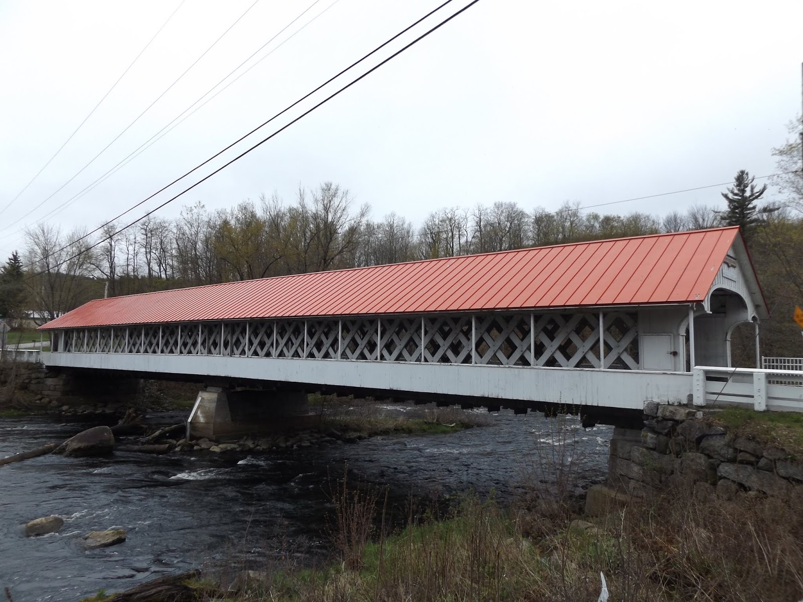
New Hampshire has dozens of covered bridges that grace their presence throughout the Granite State. One such covered bridge is the Ashuelot Covered Bridge, which spans over the Ashuelot River in the Cheshire County community of Ashuelot. Built by master covered bridge builder Nicholas Powers in 1864 at a length of 169 feet, the bridge is designed in the Town lattice style of covered bridges developed by Ithiel Town in 1820 and was rehabilitated in 1999. The bridge was built of the Ashuelot Covered Bridge is considered by local historians to be one of New Hampshire's most elaborate covered bridges. The original purpose of the bridge was to transport wood across the river for use by the Ashuelot Railroad, as the railroad had a station in the upper village of Ashuelot. Eventually, the bridge was converted for use by motor vehicles. At times. this covered bridge has also been called the Village Bridge or Village Station Bridge.


The beauty of the Ashuelot Covered Bridge, as of other covered bridges, is that it is still carrying out its original purpose, to get people and goods from Point A to Point B. There are covered walkways on each end of the bridge, so pedestrians and the occasional vehicle (the bridge sees an average of 510 vehicles a day) don't have to intermingle. At times, special events take place on the bridge, such as an annual dinner event that takes place. But in the end, the covered bridge is about bridging together the community, both now and then.


How to Get There:


Sources and Links:
Ashuelot Bridge - New Hampshire Covered Bridges
Ashuelot Covered Bridge - Bridgehunter.com
New England: True Northeast; Covered Bridge; Ashuelot, N.H. - New York Times  (June 3, 2001)

Comments

Popular posts from this blog

Dillon Road

Dillon Road is a 34.2-mile highway located in northern Coachella Valley of Riverside County, California.  Dillon Road begins at Avenue 48 on the outskirts of Indio and ends to the west at California State Route 62 near San Gorgonio Pass.  Dillon Road was developed the 1930s as a construction road for the Colorado River Aqueduct.  Dillon Road serves as a northern bypass to much of the development of Coachella Valley.  Dillon Road is known for it's frequent dips and spectacular views of San Gorgonio Pass.   Part 1; the history of Dillon Road Dillon Road was constructed as a haul road for the Colorado River Aqueduct through Coachella Valley.  The Colorado River Aqueduct spans 242 miles from Parker Dam on the Colorado River west to Lake Mathews near Corona.  Construction of the Colorado River Aqueduct began during January 1933 near Thousand Palms and was made functional on January 7, 1939.  West of Berdoo Canyon Road the alignment of Dillon Road is largely concurrent with the Colorado

Tehachapi-Willow Springs Road

Tehachapi-Willow Springs Road is an approximately 21-mile highway located in southeast Kern County.  Tehachapi-Willow Springs Road begins at Tehachapi Boulevard (former US Route 466) in Tehachapi and crosses the Tehachapi Mountains via the 4,820-foot-high Oak Creek Pass.  Tehachapi-Willow Springs Road enters Antelope Valley of the wider Mojave Desert and passes by the historic stage station of Willow Springs to a southern terminus at Rosamond Boulevard.  Tehachapi-Willow Springs Road has historic ties to the Havilah-Los Angeles Road and Stockton-Los Angeles Road due to the once reliable presence of water at Willow Springs. Part 1; the history of Tehachapi-Willow Springs Road Oak Creek Pass and Willow Springs were known to the local tribes of the Tehachapi Mountains for generations.  The first documented European crossing of Oak Creek Pass was during 1776 as part of an expedition by Francisco Garces.  Oak Creek Pass is as used again by John C. Fremont during an 1844-1845 expedition to e

The 1928 Iowa Hill Road Bridge

The 1928 Iowa Hill Road Bridge is a derelict structure located in the Sierra Nevada Mountains of Placer County, California.  The 1928 Iowa Hill Road Bridge can be found between the communities of Colfax and Iowa Hill.  The 1928 Iowa Hill Road Bridge is a wire suspension structure which spans the North Fork American River.  The 1928 Iowa Hill Road Bridge was replaced by a modern span and converted to pedestrian use following floods during 1963.   Part 1; the history of the 1928 Iowa Hill Road Bridge During 1853 gold was discovered at what to become Iowa Hill.  The gold mining claims soon led to a small community known as Iowa City being established.   By 1854, Post Office Service began at the mines of Iowa City.  By 1856 gold production at Iowa City was estimated to be around $100,000.  Iowa City was burned in fires during 1857 and 1862 but the community was rebuilt with more modernized structures.   The location of Iowa City can be seen as "Iowa Hill" on the 1873 Bancroft