Earlier in March I traveled down to Famoso of Kern County to take the original alignment of California State Route 65 north to Lindsay in Tulare County.

This blog is a spin off of the below entry on the Southern Segment of current California State Route 65.
California State Route 65; South Segment
Part 1; The Stockton-Los Angeles Road, the East Side Line, and early California State Route 65 on Legislative Route 129
The corridor of CA 65 is closely aligned to the Sierra Nevada Foothills which first became a popular route of travel as part of the Stockton-Los Angeles Road. The Stockton-Los Angeles Road came into use after the 1853 Kern River Gold Rush began. The Stockton-Los Angeles Road was a replacement of the earlier El Camino Viejo. Unlike El Camino Viejo the Stockton-Los Angeles Road avoided the dense Tule Marshes in San Joaquin Valley. The Stockton-Los Angles Road stayed close to the Sierra Foothills near the new claims on the Kern River watershed. The earlier El Camino Viejo on other hand had spur routes that traversed around Tulare Lake via the Diablo Foothills to the west and the marsh lands to the east through Kingston. The Stockton-Los Angeles Road gave rise to what is now the City of Porterville when a stage station was set up on the Tule River in 1854.
The popularity of the Stockton-Los Angeles Road began to decline rapidly as the Central Pacific Railroad through San Joaquin Valley was built through the 1870s. Farm diversions for irrigation in San Joaquin Valley and the presence of various rail sidings along the Central Pacific Railroad spurred infrastructure development which made development through previous wetlands easier. Eventually this development led to Legislative Route Number 4 being routed next to the rails in 1909 which became part of US Route 99.
The Stockton-Los Angeles Road can be seen crossing the Tule River and White River on the 1857 Britton & Rey's Highway Map of California near the present corridor of CA 65. While the Tule River Station isn't listed Stickney's Ferry can be seen crossing the White River.

Fortunately for Porterville and the communities that were located on the Stockton-Los Angeles Road they didn't remain off a main route of transportation for very long. The Southern Pacific Railroad brought service to eastern San Joaquin Valley in 1888 via it's East Side Line. In time the East Side Line came to be known as the Stockton-Tulare Railroad. The Stockton-Tulare Railroad split from the mainline in Fresno and merged back in at Famoso. The Stockton-Tulare Railroad can be seen on this 1892 Map of Tulare County.


The Southern Pacific Railroad built frontage facilities along the Stockton-Tulare Railroad which became the main highway through eastern San Joaquin Valley. This highway was a close analog to what would become CA 65 and can be seen on the 1917 California State Automobile Association Map.

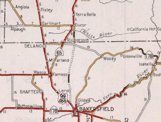
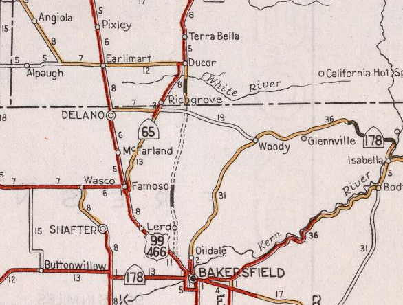
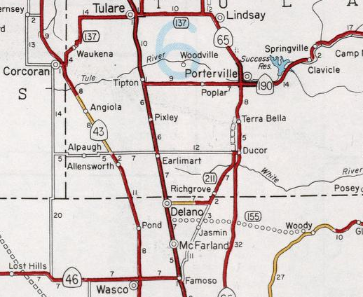
In 1929 Legislative Route Number 129 was added to the State Highway System with a loose definition of "near Bakersfield" to General Grant National Park (modern Kings Canyon National Park). The original southern terminus of LRN 129 met US 99/LRN 4 in Delano via Garces Highway which can be seen on the 1930 Division of Highways State Map.
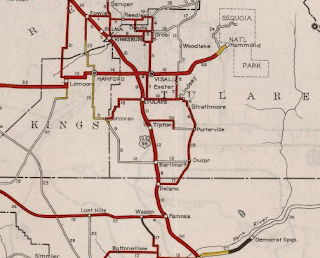
By 1934 the southern terminus of LRN 129 was shifted to Famoso via the newly constructed Famoso-Porterville Highway where it terminated at US Route 99/LRN 4. The new alignment of LRN 129 can be seen entering Famoso on the 1934 Division of Highways State Map.

In the August 1934 California Highways & Public Works ("CHPW") guide the Sign State Routes were announced. CA 65 was added to LRN 129 and terminated in Famoso at US 99/LRN 4.


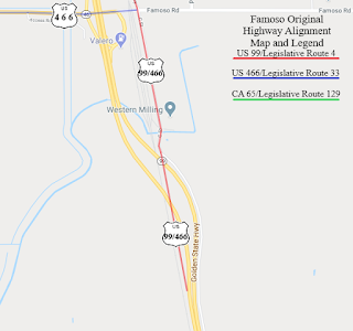
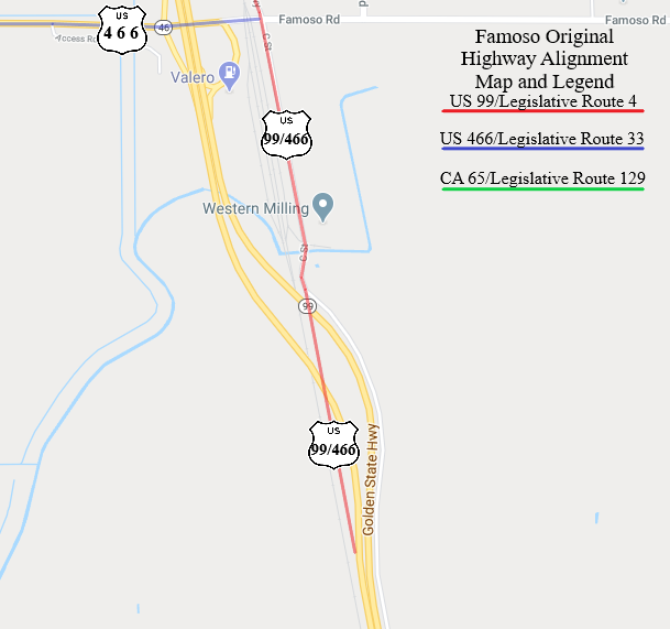
The below map illustrations show the alignments of; US 99/LRN 4, US 466/LRN 33, and CA 65/LRN 129 through Famoso as they were 1934. Note; US 99/LRN 4 took two hazardous at-grade crossings of the Southern Pacific Railroad as cited above.

The May 1936 CHPW guide cites that the railroad subway in Famoso was under construction and a similar subway structure in nearby Delano was recently completed.

US 99/US 466/LRN 4 is shown to be aligned over a new subway overpass onto a bypass route of Famoso on the 1938 Division of Highways State Map. The shift of US 99/US 466/LRN 4 onto the new bypass route extended the southern terminus of CA 65 within Famoso to the end of C Street. The bypass route of Famoso used by US 99/US 466/LRN 4 essentially was built on the same grade CA 99 on the Golden State Freeway occupies today.

The new Ducor Cut-Off alignment of CA 65/LRN 129 first appears in an article in the July 1940 CHPW Guide. The Ducor Cut-Off is cited as being planned to shift CA 65 near the oil farms north of Bakersfield and shorten the distance of travel to Ducor by 5 miles over the then existing route on Famoso-Porterville Highway. A portion of the Ducor Cut-Off is shown to have been completed by July 1940.


The Ducor Cut-Off first appears on the 1940 Division of Highways State Map. A portion of the Ducor Cut-Off south of Ducor and the White River is shown completed as pictured above.
The Ducor Cut-Off appears as completed on the 1948 Division of Highways State Map and CA 65/LRN 129 is shown shifted to it off of Famoso-Porterville Highway. The shift of CA 65/LRN 129 marked the end of State Highway service through the heart of Famoso. Part of Famoso-Porterville Highway remained in the State Highway System from Richgrove north to Ducor as a consolidated segment of LRN 136

By 1957 CA 65/LRN 129 was moved onto a bypass of downtown Porterville which can be seen on the Division of Highways State Map from said year. This changed removed State Highway service from Main Street in Porterville.

During the 1964 State Highway Renumbering all Legislative Route Numbers were dropped. Former CA 65 on Famoso-Porterville Highway on LRN 136 became the first CA 211 which can be seen on the 1964 Division of Highways State Map.

A planned bypass route for CA 65 around Ducor and Terra Bella first appears on the 1966 Division of Highways State Map.

By 1967 the first CA 211 on Famoso-Porterville Highway was relinquished. What had been CA 211 on Graces Highway was consolidated into a realigned CA 155. These changes can be seen on the 1967 Division of Highways State Map.

The Ducor-Terra Bella bypass route of CA 65 is shown to be complete on the 1969 Division of Highways State Map. This was the last segment of the original CA 65 alignment between Famoso and Lindsay that was replaced by the current highway. This in effect removed Road 236 from State Highway service.

Much of the original CA 65 became segments of the following Sign County Routes:
- Famoso-Porterville Highway from Richgrove north to Avenue 56 in Ducor became Sign County Route J35 in 1975.
- Avenue 56 from Famoso-Porterville Highway east to Road 236 in Ducor became part of Sign County Route J22 in 1968.
- Road 236, Main Street, Orange Belt Drive, Mirage Avenue, and Hermosa Street became part of Sign County Route J29 in 1971.
Part 2; A drive on the original CA 65 from Famoso to Lindsay
I began my drive on the original alignment of CA 65 on what was also once US 99/US 466 on C Street in Famoso. C Street ends at the Union Pacific Railroad next to the current CA 99 overpass. When the Southern Pacific Subway was completed circa 1937-1938 this became the south terminus of CA 65/LRN 129.

From the closed portion of C Street I turned around and headed north. C
Street originally continued north of Famoso Road and became
Famoso-Porterville Highway at Poso Creek. C Street now no longer
continues north of Famoso Road and the bridge over Poso Creek has been
removed.


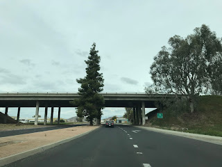
Famoso-Porterville Highway is closed from Famoso Road north over Poso Creek to McCombs Road on private property. The original US 99/LRN 4 overpass of the Southern Pacific Railroad was located just south of McCombs Road. The photos below shows the intersection of McCombs Road and Famoso-Porterville Highway which is the closest approximation I could get of the original south terminus of CA 65/LRN 129 at US 99/LRN 4.


Pomfret Memorial Cemetery is located at the northeast corner of Famoso-Porterville Highway and McCombs Road. Pomfret Memorial Cemetery was once known as Famoso Cemetery and houses burial sites (talk about a...ghost town!) dating to the heyday of the siding between 1888-1917.

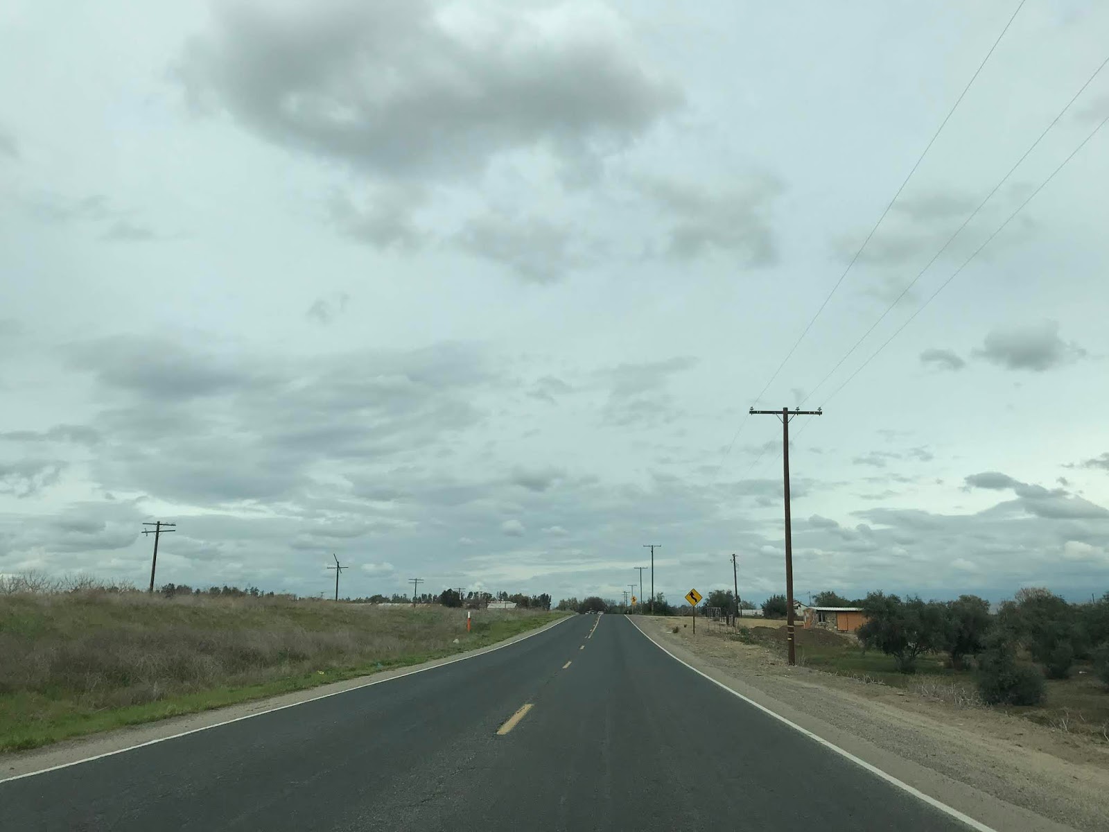
From McCombs Road I turned northeast on former CA 65 on Famoso-Porterville Highway towards Richgrove. The grade of the Stockton-Tulare Railroad between Famoso and Richgrove is located to the west of Famoso-Porterville Highway. I'm to understand that the Stockton-Tulare Railroad shuttered in the 1990s as the Southern Pacific was about to be absorbed into the Union Pacific Railroad. Much of the rails of the Stockton-Tulare Railroad were removed in the past two decades which has left a visible grade scar along much of the original alignment of CA 65.
Famoso-Porterville Highway is an almost direct route to Richgrove but has a couple 90 degree shifts. Famoso-Porterville Highway has some important local intersections such as; Elmo Highway, Pond Road, and Woolholmes Avenue before reaching CA 155/Garces Highway.


From CA 155 the route of Famoso-Porterville Highway crosses the Tulare County Line and enters Richgrove proper. Famoso-Porterville Highway is sometimes referred to as "Richgrove Drive" within Richgrove proper. At Avenue 4 former CA 65 on Richgrove Drive becomes Sign County Route J35 and intersects Sign County Route J44 (on Avenue 4). Note; the only remaining Sign County Route in Tulare County to still have field signage is J37 on Balch Park Road.


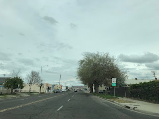
Richgrove still appears to be a somewhat bustling community despite the loss of the Stockton-Tulare Railroad. This old frontage building has painted signage declaring it the "Richgrove Swap Meet." This photo was take from the grade of the Stockton-Tulare Railroad at the intersection of Richgrove Drive (J35) and Avenue 4 (J44).

Former CA 65 continues northeast through Richgrove on J35/Richgrove Drive where it emerges into the plains north of the community. Approaching Avenue 32 the route J35/Richgrove Drive passes by an old Southern California Edison substation.


Former CA 65 on J35/Richgrove Drive makes an easterly turn and crosses the grade of the Stockton-Tulare Railroad.


J35/Richgrove Drive turns north approaching the White River and transitions onto Road 232. The rail trestles of the Stockton-Tulare Railroad are still present at the White River crossing. A highway bridge with a date stamp of 1931 can be found on J35/Road 232 at the White River which serves as a reminder of the Post-1929 construction of LRN 129.


J35/Road 232 north pulls alongside the western flank of modern CA 65 and terminates at J22/Avenue 56. Former CA 65 would have made a right hand turn onto Avenue 56 towards Ducor.


J22/Avenue 56 crosses modern CA 65 and enters Ducor proper.


At Carlisle Road J22/Avenue 56 reaches the grade of the Stockton-Tulare Railroad.


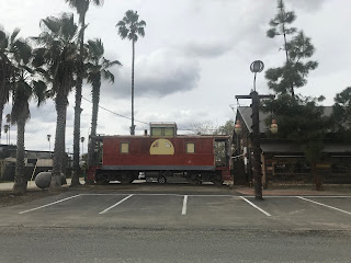
Ducor was settled in 1885 by four German Homesteaders and was known as Dutch Corner. Dutch Corner became a siding of the Southern Pacific Railroad in 1888. The name "Ducor" is a consolidation of the original name "Dutch Corner." The Dutch Frontier building has numerous railroad displays which can be found on the grade of the Stockton-Tulare Railroad.


Former CA 65 would have made a left hand turn off J22/Avenue 56 onto Road 236/J29. Avenue 56 continues directly into the Sierra Nevada Mountains towards California Hot Springs as Mountain Road 56. Mountain Road 56 can be used to reach the awesome Trans-Sierra Highway of Sherman Pass Road.

Former CA 65 on J29/Road 236 continues north from Ducor following the grade of the Stockton-Tulare Railroad to Terra Bella. At Avenue 95 (sometimes referred to as Terra Bella Avenue) J29/Road 236 intersects Sign County Route J24.


J29/Road 236 becomes Road 238 north of Terra Bella and Main Street upon entering Porterville. Numerous abandoned rail road trestles of the Stockton-Tulare Railroad can be seen north of Terra Bella approaching Porterville.


Upon entering Porterville J29/Main Street intersects modern CA 190.

J29/Main Street crosses the Tule River into downtown Porterville and encounters an important intersection at Orange Avenue.


CA 190 was originally routed through downtown Porterville from Poplar Avenue on a multiplex of CA 65 on Main Street. CA 190 continued east through Porterville on Orange Avenue, Date Avenue, and Springville Avenue. CA 190 was realigned onto the modern expressway alignment in sections from 1960 to 1964 as part of the Lake Success Project. This illustration below describes the original routing of CA 190 from downtown Porterville to the Success Dam.

J29/Main Street passes through downtown Porterville and passes by North Park at Henderson Avenue. North Park marks the original location Peter Goodhue operated Tule River Station on the Stockton-Los Angeles Road beginning in 1854. In 1860 Tule River Station was bought by Royal Porter Putnam. In 1862 the Tule River changed to it's present course and Tule River Station became a Stage on the Butterfield Overland Mail Route. Porterville was officially founded in 1864 and is named for Royal Porter Putnam.


North of Porterville J29 starts to swing northwest onto Orange Belt Drive and eventually enters Strathmore. At Avenue 196 J29/Orange Belt Drive intersects Sign County Route J28 in downtown Strathmore. J29 and Old CA 65 essentially follow the grade of the Stockton-Tulare Railroad slightly eastward and uphill on Orange Belt Drive.


From Strathmore the rails of the Stockton-Tulare Railroad are still present just west of J29/Orange Belt Drive. J29 and Old CA 65 transition onto Mirage Avenue upon entering Lindsay.


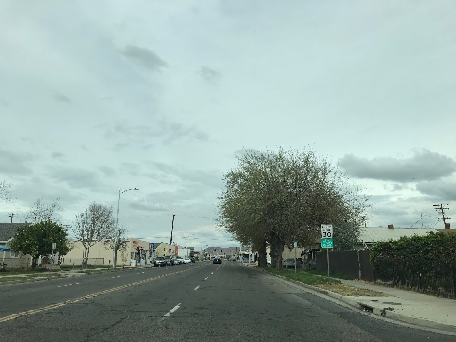
J29 and Old CA 65 follow Mirage Avenue to downtown Lindsay where they make a left hand turn onto Hermosa Street.


J29 and Old CA 65 follow Hermosa Street over the tracks of the Stockton-Tulare Railroad west to modern CA 65. J29 terminates at modern CA 65 on Hermosa Street. Modern CA 65 and Hermosa Street is where the older highway merges into the current alignment.


This blog is a spin off of the below entry on the Southern Segment of current California State Route 65.
California State Route 65; South Segment
Part 1; The Stockton-Los Angeles Road, the East Side Line, and early California State Route 65 on Legislative Route 129
The corridor of CA 65 is closely aligned to the Sierra Nevada Foothills which first became a popular route of travel as part of the Stockton-Los Angeles Road. The Stockton-Los Angeles Road came into use after the 1853 Kern River Gold Rush began. The Stockton-Los Angeles Road was a replacement of the earlier El Camino Viejo. Unlike El Camino Viejo the Stockton-Los Angeles Road avoided the dense Tule Marshes in San Joaquin Valley. The Stockton-Los Angles Road stayed close to the Sierra Foothills near the new claims on the Kern River watershed. The earlier El Camino Viejo on other hand had spur routes that traversed around Tulare Lake via the Diablo Foothills to the west and the marsh lands to the east through Kingston. The Stockton-Los Angeles Road gave rise to what is now the City of Porterville when a stage station was set up on the Tule River in 1854.
The popularity of the Stockton-Los Angeles Road began to decline rapidly as the Central Pacific Railroad through San Joaquin Valley was built through the 1870s. Farm diversions for irrigation in San Joaquin Valley and the presence of various rail sidings along the Central Pacific Railroad spurred infrastructure development which made development through previous wetlands easier. Eventually this development led to Legislative Route Number 4 being routed next to the rails in 1909 which became part of US Route 99.
The Stockton-Los Angeles Road can be seen crossing the Tule River and White River on the 1857 Britton & Rey's Highway Map of California near the present corridor of CA 65. While the Tule River Station isn't listed Stickney's Ferry can be seen crossing the White River.

Fortunately for Porterville and the communities that were located on the Stockton-Los Angeles Road they didn't remain off a main route of transportation for very long. The Southern Pacific Railroad brought service to eastern San Joaquin Valley in 1888 via it's East Side Line. In time the East Side Line came to be known as the Stockton-Tulare Railroad. The Stockton-Tulare Railroad split from the mainline in Fresno and merged back in at Famoso. The Stockton-Tulare Railroad can be seen on this 1892 Map of Tulare County.


The Southern Pacific Railroad built frontage facilities along the Stockton-Tulare Railroad which became the main highway through eastern San Joaquin Valley. This highway was a close analog to what would become CA 65 and can be seen on the 1917 California State Automobile Association Map.

In 1929 Legislative Route Number 129 was added to the State Highway System with a loose definition of "near Bakersfield" to General Grant National Park (modern Kings Canyon National Park). The original southern terminus of LRN 129 met US 99/LRN 4 in Delano via Garces Highway which can be seen on the 1930 Division of Highways State Map.

By 1934 the southern terminus of LRN 129 was shifted to Famoso via the newly constructed Famoso-Porterville Highway where it terminated at US Route 99/LRN 4. The new alignment of LRN 129 can be seen entering Famoso on the 1934 Division of Highways State Map.

In the August 1934 California Highways & Public Works ("CHPW") guide the Sign State Routes were announced. CA 65 was added to LRN 129 and terminated in Famoso at US 99/LRN 4.

The below map illustrations show the alignments of; US 99/LRN 4, US 466/LRN 33, and CA 65/LRN 129 through Famoso as they were 1934. Note; US 99/LRN 4 took two hazardous at-grade crossings of the Southern Pacific Railroad as cited above.

The May 1936 CHPW guide cites that the railroad subway in Famoso was under construction and a similar subway structure in nearby Delano was recently completed.
US 99/US 466/LRN 4 is shown to be aligned over a new subway overpass onto a bypass route of Famoso on the 1938 Division of Highways State Map. The shift of US 99/US 466/LRN 4 onto the new bypass route extended the southern terminus of CA 65 within Famoso to the end of C Street. The bypass route of Famoso used by US 99/US 466/LRN 4 essentially was built on the same grade CA 99 on the Golden State Freeway occupies today.

The new Ducor Cut-Off alignment of CA 65/LRN 129 first appears in an article in the July 1940 CHPW Guide. The Ducor Cut-Off is cited as being planned to shift CA 65 near the oil farms north of Bakersfield and shorten the distance of travel to Ducor by 5 miles over the then existing route on Famoso-Porterville Highway. A portion of the Ducor Cut-Off is shown to have been completed by July 1940.


The Ducor Cut-Off first appears on the 1940 Division of Highways State Map. A portion of the Ducor Cut-Off south of Ducor and the White River is shown completed as pictured above.
The Ducor Cut-Off appears as completed on the 1948 Division of Highways State Map and CA 65/LRN 129 is shown shifted to it off of Famoso-Porterville Highway. The shift of CA 65/LRN 129 marked the end of State Highway service through the heart of Famoso. Part of Famoso-Porterville Highway remained in the State Highway System from Richgrove north to Ducor as a consolidated segment of LRN 136

By 1957 CA 65/LRN 129 was moved onto a bypass of downtown Porterville which can be seen on the Division of Highways State Map from said year. This changed removed State Highway service from Main Street in Porterville.

During the 1964 State Highway Renumbering all Legislative Route Numbers were dropped. Former CA 65 on Famoso-Porterville Highway on LRN 136 became the first CA 211 which can be seen on the 1964 Division of Highways State Map.

A planned bypass route for CA 65 around Ducor and Terra Bella first appears on the 1966 Division of Highways State Map.
By 1967 the first CA 211 on Famoso-Porterville Highway was relinquished. What had been CA 211 on Graces Highway was consolidated into a realigned CA 155. These changes can be seen on the 1967 Division of Highways State Map.

The Ducor-Terra Bella bypass route of CA 65 is shown to be complete on the 1969 Division of Highways State Map. This was the last segment of the original CA 65 alignment between Famoso and Lindsay that was replaced by the current highway. This in effect removed Road 236 from State Highway service.

Much of the original CA 65 became segments of the following Sign County Routes:
- Famoso-Porterville Highway from Richgrove north to Avenue 56 in Ducor became Sign County Route J35 in 1975.
- Avenue 56 from Famoso-Porterville Highway east to Road 236 in Ducor became part of Sign County Route J22 in 1968.
- Road 236, Main Street, Orange Belt Drive, Mirage Avenue, and Hermosa Street became part of Sign County Route J29 in 1971.
Part 2; A drive on the original CA 65 from Famoso to Lindsay
I began my drive on the original alignment of CA 65 on what was also once US 99/US 466 on C Street in Famoso. C Street ends at the Union Pacific Railroad next to the current CA 99 overpass. When the Southern Pacific Subway was completed circa 1937-1938 this became the south terminus of CA 65/LRN 129.

Famoso is a ghost town and former Southern Pacific Railroad siding
located in northern Kern County on Poso Creek. The site of Famoso is
located roughly at the junction of CA 99 and CA 46. Famoso was founded
as a Southern Pacific Railroad siding known as "Poso" during the early
1870s when the Southern Pacific Railroad was building it's main freight
line through San Joaquin Valley. The name of Poso was changed in 1888
to Spottiswood when the community received a spur line of the Southern
Pacific and Post Office Service. The community name of Poso was already
in use by a mining community to the west in San Luis Obispo County
which required a new name be chosen to establish Post Office Service.
The name of Spottiswood was changed to Famoso in 1895.


Famoso-Porterville Highway is closed from Famoso Road north over Poso Creek to McCombs Road on private property. The original US 99/LRN 4 overpass of the Southern Pacific Railroad was located just south of McCombs Road. The photos below shows the intersection of McCombs Road and Famoso-Porterville Highway which is the closest approximation I could get of the original south terminus of CA 65/LRN 129 at US 99/LRN 4.


Pomfret Memorial Cemetery is located at the northeast corner of Famoso-Porterville Highway and McCombs Road. Pomfret Memorial Cemetery was once known as Famoso Cemetery and houses burial sites (talk about a...ghost town!) dating to the heyday of the siding between 1888-1917.

From McCombs Road I turned northeast on former CA 65 on Famoso-Porterville Highway towards Richgrove. The grade of the Stockton-Tulare Railroad between Famoso and Richgrove is located to the west of Famoso-Porterville Highway. I'm to understand that the Stockton-Tulare Railroad shuttered in the 1990s as the Southern Pacific was about to be absorbed into the Union Pacific Railroad. Much of the rails of the Stockton-Tulare Railroad were removed in the past two decades which has left a visible grade scar along much of the original alignment of CA 65.
Famoso-Porterville Highway is an almost direct route to Richgrove but has a couple 90 degree shifts. Famoso-Porterville Highway has some important local intersections such as; Elmo Highway, Pond Road, and Woolholmes Avenue before reaching CA 155/Garces Highway.


From CA 155 the route of Famoso-Porterville Highway crosses the Tulare County Line and enters Richgrove proper. Famoso-Porterville Highway is sometimes referred to as "Richgrove Drive" within Richgrove proper. At Avenue 4 former CA 65 on Richgrove Drive becomes Sign County Route J35 and intersects Sign County Route J44 (on Avenue 4). Note; the only remaining Sign County Route in Tulare County to still have field signage is J37 on Balch Park Road.


Richgrove still appears to be a somewhat bustling community despite the loss of the Stockton-Tulare Railroad. This old frontage building has painted signage declaring it the "Richgrove Swap Meet." This photo was take from the grade of the Stockton-Tulare Railroad at the intersection of Richgrove Drive (J35) and Avenue 4 (J44).

Former CA 65 continues northeast through Richgrove on J35/Richgrove Drive where it emerges into the plains north of the community. Approaching Avenue 32 the route J35/Richgrove Drive passes by an old Southern California Edison substation.


Former CA 65 on J35/Richgrove Drive makes an easterly turn and crosses the grade of the Stockton-Tulare Railroad.


J35/Richgrove Drive turns north approaching the White River and transitions onto Road 232. The rail trestles of the Stockton-Tulare Railroad are still present at the White River crossing. A highway bridge with a date stamp of 1931 can be found on J35/Road 232 at the White River which serves as a reminder of the Post-1929 construction of LRN 129.


J35/Road 232 north pulls alongside the western flank of modern CA 65 and terminates at J22/Avenue 56. Former CA 65 would have made a right hand turn onto Avenue 56 towards Ducor.


J22/Avenue 56 crosses modern CA 65 and enters Ducor proper.


At Carlisle Road J22/Avenue 56 reaches the grade of the Stockton-Tulare Railroad.


Ducor was settled in 1885 by four German Homesteaders and was known as Dutch Corner. Dutch Corner became a siding of the Southern Pacific Railroad in 1888. The name "Ducor" is a consolidation of the original name "Dutch Corner." The Dutch Frontier building has numerous railroad displays which can be found on the grade of the Stockton-Tulare Railroad.


Former CA 65 would have made a left hand turn off J22/Avenue 56 onto Road 236/J29. Avenue 56 continues directly into the Sierra Nevada Mountains towards California Hot Springs as Mountain Road 56. Mountain Road 56 can be used to reach the awesome Trans-Sierra Highway of Sherman Pass Road.

Former CA 65 on J29/Road 236 continues north from Ducor following the grade of the Stockton-Tulare Railroad to Terra Bella. At Avenue 95 (sometimes referred to as Terra Bella Avenue) J29/Road 236 intersects Sign County Route J24.


Upon entering Porterville J29/Main Street intersects modern CA 190.


J29/Main Street crosses the Tule River into downtown Porterville and encounters an important intersection at Orange Avenue.


CA 190 was originally routed through downtown Porterville from Poplar Avenue on a multiplex of CA 65 on Main Street. CA 190 continued east through Porterville on Orange Avenue, Date Avenue, and Springville Avenue. CA 190 was realigned onto the modern expressway alignment in sections from 1960 to 1964 as part of the Lake Success Project. This illustration below describes the original routing of CA 190 from downtown Porterville to the Success Dam.

J29/Main Street passes through downtown Porterville and passes by North Park at Henderson Avenue. North Park marks the original location Peter Goodhue operated Tule River Station on the Stockton-Los Angeles Road beginning in 1854. In 1860 Tule River Station was bought by Royal Porter Putnam. In 1862 the Tule River changed to it's present course and Tule River Station became a Stage on the Butterfield Overland Mail Route. Porterville was officially founded in 1864 and is named for Royal Porter Putnam.


North of Porterville J29 starts to swing northwest onto Orange Belt Drive and eventually enters Strathmore. At Avenue 196 J29/Orange Belt Drive intersects Sign County Route J28 in downtown Strathmore. J29 and Old CA 65 essentially follow the grade of the Stockton-Tulare Railroad slightly eastward and uphill on Orange Belt Drive.


From Strathmore the rails of the Stockton-Tulare Railroad are still present just west of J29/Orange Belt Drive. J29 and Old CA 65 transition onto Mirage Avenue upon entering Lindsay.


J29 and Old CA 65 follow Mirage Avenue to downtown Lindsay where they make a left hand turn onto Hermosa Street.


J29 and Old CA 65 follow Hermosa Street over the tracks of the Stockton-Tulare Railroad west to modern CA 65. J29 terminates at modern CA 65 on Hermosa Street. Modern CA 65 and Hermosa Street is where the older highway merges into the current alignment.


Comments