In the Franklin County town of New Sharon in central Maine was a bridge that was on a former alignment of US 2 through New Sharon. At the time of the bridge's demolition in February 2014, the New Sharon Bridge was the last known surviving pin-connected highway truss throughout the entire state of Maine. Built in 1916 by New York's Croton Bridge Company, the New Sharon Bridge spanned over the Sandy River. A couple of friends and I visited the old bridge in early September 2004. At the time, it was meant to be a temporary bridge closure.
![](https://blogger.googleusercontent.com/img/b/R29vZ2xl/AVvXsEjg-V2jO56G2HdI5rXrzRvvL2gT42W1WW2fySe0aIdkEEhYZtkDwIGrlfwb2-ylgxkBFuPfmLgo7T7I_j66NPbwpREJfYUIULrfkSf4LFNliozP8EykGSnIWHBFmLzSwhHpWral7g/s640/nsb1.jpg) |
Looking at the old truss bridge from the east. |
![](https://blogger.googleusercontent.com/img/b/R29vZ2xl/AVvXsEgYfj_2SSO_NpwsO1VR42eCEExKqBzk9XG53zYBy3Kot8F6hWpguN9D-vSOBlrtKl1wLafnvAIVC3pwfRwCSo6g6jSflq55PoeWJZ1IF1CoKGjvBE8YG5lptf7fmmiDVWMZ-8kjCA/s640/nsb2.jpg) |
A view of the modern bridge that carries US 2, ME 27 and ME 134 over the Sandy River. |
![](https://blogger.googleusercontent.com/img/b/R29vZ2xl/AVvXsEipg5NbEL38Nbyy7IjIqunJhhF4oWFNeCoKOcxDxeGOewvzqCgL_juvSpvHY4ADg6jjigaognxwfMvQMkPGt4W6B0Ph4IW1oQJzDSR3aXwK1ADgyyVnzZLzdJygxMEDNYo51nT73Q/s640/nsb3.jpg) |
The Sandy River looking south as seen from the bridge. This is what a lot of interior Maine looks like in the summer. |
![](https://blogger.googleusercontent.com/img/b/R29vZ2xl/AVvXsEg_S42BwrHN5zH1V8ShTmJl-OcTslhjCv4vwbXnzMoSj7RBc3ZPu766JIkQCGBtaThZa2YLyEM4HwQIlItcOghWYMhhP3Qd-tNJGqIskxf7ihIGPia4Il0fBis7yNhtOJc7cyJ9uw/s640/nsb4.jpg) |
Looking east from the bridge. You can notice the steel deck and that the bridge was probably a bottleneck during its heyday. The bridge leads to a mostly dirt path. |
![](https://blogger.googleusercontent.com/img/b/R29vZ2xl/AVvXsEiY8_YQqCdO7LaUL3SB8PY0qnO5XYjQSPa_6dFMPMw1zh97vRgRrx4DwehxrI9HbKDpIUcmEgiPmvIPWpYB7T059ptiYFiwTL9lswh9XG0iC8fIgN6jyKnwJRNGhvoQ46sLRb36cA/s640/nsb5.jpg) |
New Sharon as seen looking west from the bridge. As you can see, a barricade has been around for a while. |
![](https://blogger.googleusercontent.com/img/b/R29vZ2xl/AVvXsEiLTSPy9KSZSZTb60toAKcAw7bXbz-lhbZU_F2i5taLNoN0JKQzdi4wkdEzmseVFImR7yzPCkpWyZru8ekripp_fjBw5trSERWjfSL59lRTI_49UBpvO3dE3X2271TFu3uInPoiFw/s640/nsb6.jpg) |
The weight limit of the bridge is 3 tons, but someone took the liberty of changing the limit. |
![](https://blogger.googleusercontent.com/img/b/R29vZ2xl/AVvXsEgafzH_ZFzln5YpqxuTCNlUCFxG1hLd8t2_kJCymM-RUcuPtzuyYbpSFTme4TsSvzs5PqRpQZ0kBDH6OZ-9WzJNN71D7oWDk4T9EIwb7gz-NJySPLRQNQwg0Ex2avdg1mZIX0VtQA/s640/nsb7.jpg) |
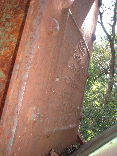
A plaque on the base of the bridge about when it was built. Looks like the bridge was built by the Croton Bridge Company in 1916. |
![](https://blogger.googleusercontent.com/img/b/R29vZ2xl/AVvXsEiyxkq6qMB6KIr3Mxic2-r41muf0yvp7TAZ3zDzTQC2Zd4gMDQx2Cq2GGP8Xf4GtywxHGDQ60-J0AnCYCPbnZ3BlaHu1EzYmFmhfOpam-slrq6i4_Fg3XEhyqXwdz0dYsvXRfPnRg/s640/nsb8.jpg) |
Can't make out this plaque as well, maybe it is honoring the bridge builders or perhaps a few trustees. |
![](https://blogger.googleusercontent.com/img/b/R29vZ2xl/AVvXsEhST3IHIeNIpzohs3Zqon2f3jsCVPXJsH1gplM6uYJhFWONn4PuoRJszxtbo-qX1gB9hJ7JqdZIPf1vCD_AEf1gexWr2CmJLqPjOaeCDfvyRt8qcakffNWp-759v9fxjlDufM9O7Q/s640/nsb9.jpg) |
Sign stating that the bridge is closed, temporarily. Unfortunately, it is now closed permanently as the bridge was demolished in 2014, some ten years after I took this photo. |
Sources and Links:
Bridgehunter -
New Sharon Bridge
Comments