Friday morning I headed up to Yosemite to do some hiking and find an old alignment of the Wawona Road. Since the trip entailed a trek on California State Route 41 north over the San Joaquin River into Madera County I decided to finish photographing and documenting the last section of the route I haven't done a blog on.

Interestingly I've already written a couple blogs about the previous alignment history of CA 41 in Madera County. The first blog details the history of the 1889 and 1941 Lanes Bridge over the San Joaquin River.
1941 Lanes Bridge Renovation
Recently I also took a drive on Road 425b south of Oakhurst which along with Road 425c and Road 426 were original alignments of CA 41. I go into way more detail on those roads on this blog post.
Old California State Route 41 on Road 425C, Road 425B, Road 425A, and Old Yosemite Road
The morning started out in Fresno northbound on CA 41 approaching the San Joaquin River. Yosemite is prominently displayed on the guide signs for northbound CA 41.

Approaching the San Joaquin River the north terminus of CA 41 is 52 miles away at the Wawona Road.

A map of CA 41 north from the Madera County Line to the Wawona Road Entrance of Yosemite National Park can be found below.

The 1941 Lanes Bridge can be seen off to the right of the CA 41 freeway still undergoing a seismic retrofit. I still find it odd that Caltrans maintains a bridge that essentially is just used to access a trailer park on the San Joaquin River.

The Madera County line is in middle of the crossing of the San Joaquin River at approximately Post Mile FRE 33.450.

CA 41 quickly drops down to a two-lane road after entering Madera County.

The previous alignment of CA 41 which would have connected with the 1941 Lanes Bridge is west of the modern road and is actually signed as a CA 41 Business Loop.

North of Avenue 15 CA 41 crosses the 36 mile Madera Canal which drains water from Millerton Lake northwest towards the Chowchilla River.

CA 41 northbound next junctions the north terminus of CA 145 at Post Mile MAD 9.247. An implied continuation of CA 145 continues east towards Friant/Millerton Lake from CA 41 and is signed as Road 145.


North of CA 145 the boundary for Yosemite is still 42 miles away.

The segment of CA 41 north of CA 145 is signed as the Southern Yosemite Highway. The sign assembly is very unique and completely green in color.

North of CA 145 the first of many passing zones opens up. This particular passing zone was completed some time last year.

CA 41 enters the Sierra Foothills and ascends above 1,000 feet in elevation.


Another passing lane northbound opens up approaching North Fork Road at Post Mile MAD 17.912. North Fork Road is a major junction which heads northeast to North Fork and generally the quickest way from Fresno to Bass Lake. North Fork Road is also signed as the south access point connecting to Sierra National Forest Route 81 of the Sierra Vista Scenic Byway.


After North Fork Road there is a wide vista of the Sierras to the north.

Two more passing zones open up on the approach to 2,000 feet above sea level.


There is another passing zone before CA 41 enters Coarsegold.


Apparently there was mining claims around Coarsegold back during the early days of the California Gold Rush. Coarsegold seems to not have been significant enough to have received Postal Service until the late 1870s. Coarsegold is the location where CA 41 junctions Raymond Road which takes a western swing out of the Sierras.

Coarsegold is located in Deadwood Gulch. CA 41 utilizes Deadwood Gulch north out of Coarsegold to approach Oakhurst, the Yosemite National Park boundary is 23 miles to the north. Road 425c, a previous alignment of CA 41 is located in Deadwood Gulch.

CA 41 widens to a passing area climbing out of Deadwood Gulch and climbs over 3,000 feet before approaching Road 425b. Road 425b descends on a series of hairpins down to Road 426 which likely was a rough ride in the early days of CA 41.


Modern CA 41 is west of Road 425b and takes a straighter descent down into Oakhurst. The descent to Oakhurst and the Fresno River is pretty dramatic considering they are at 2,274 feet above sea level. The south terminus of CA 49 is located on the north bank of the Fresno River in downtown Oakhurst at approximately Post Mile MAD 35.452. Oakhurst lies within what is known as Crane Valley.


CA 41 junctions it's former alignment in downtown Oakhurst at Road 426 at Post Mile MAD 35.761. Oakhurst was originally founded as Fresno Flats in the 1870s and was primarily a saw mill town. Apparently the name of Oakhurst dates back to a change made in 1912. Aside from being a gateway to Yosemite the community of Oakhurst is probably best known for being the former headquarters of Sierra On-Line. Sierra used to produce many early era PC adventure games like Kings Quest and Police Quest.

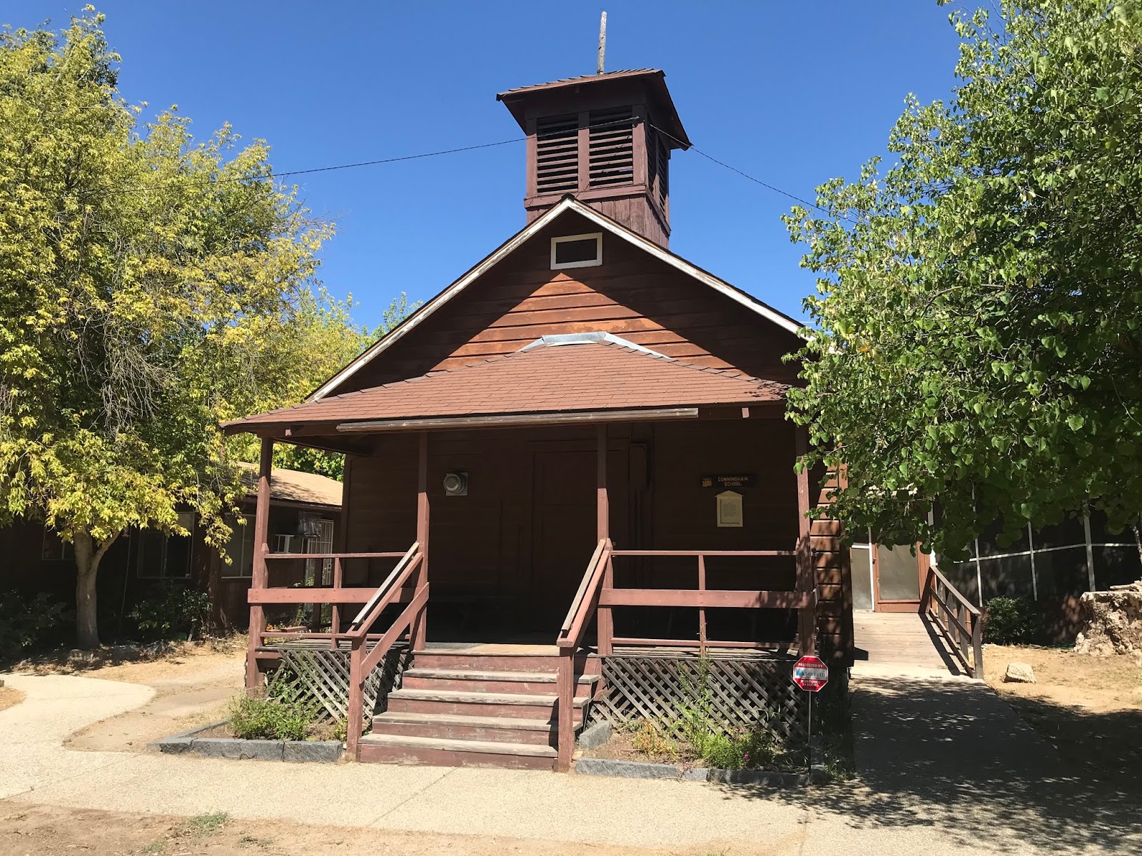
Detouring from CA 41 onto Road 426 High School Road one can access the Fresno Flats Historical Park. The Fresno Flats Historical Park contains numerous buildings original to the community that were salvaged and restored. The Fresno Flats Historical Park has numerous stations detailing the history of the community as it evolved into modern day Oakhurst.


Exiting Oakhurst northward the boundary for Yosemite National Park is 14 miles away. The grade above Oakhurst quickly ascends back above 3,000 feet before the last major junction at Bass Lake Road at Post Mile MAD 39.006.


North of Bass Lake Road CA 41 passes by the north connecting road to the Sierra Vista Scenic Byway at Road 632 and enters Sierra National Forest. CA 41 rises quickly to 4,000 feet above sea level upon entering Sierra National Forest.


CA 41 in Sierra National Forest is very twisty and is a fun drive when you're the only person on the road. CA 41 skirts the county line but entering Mariposa County for a brief time before reentering Madera County also for a brief time. After a short trek through Madera County CA 41 enters Mariposa County again where the end of the truck access route is signed in front of a Forest Service Station.


The Yosemite Mountain Sugar Pine Railroad is located off of CA 41 in Mariposa County. The YMSPR is a narrow gauge railroad which once was used for logging operations. The YMSPR has several narrow gauge locomotives that can be accessed for a tour of the 4 miles of track that remain. The YMSPR was built upon the former right-of-way of the Madera Sugar Pine Railroad which operated from near the beginnings of the 20th century to the early 1930s.

CA 41 ascends to 5,000 feet above sea level before entering Fish Camp. Last year this area was affected by a large forest fire and the effects on treeline next to CA 41 are very obvious. Fish Camp dates back to the 1920s and apparently was named after a local fish hatchery.


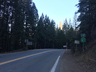
North of Fish Camp CA 41 terminates at the boundary of Yosemite National Park. The road continues to Yosemite Valley as the Wawona Road at Post Mile MPA 4.918.

Interestingly I've already written a couple blogs about the previous alignment history of CA 41 in Madera County. The first blog details the history of the 1889 and 1941 Lanes Bridge over the San Joaquin River.
1941 Lanes Bridge Renovation
Recently I also took a drive on Road 425b south of Oakhurst which along with Road 425c and Road 426 were original alignments of CA 41. I go into way more detail on those roads on this blog post.
Old California State Route 41 on Road 425C, Road 425B, Road 425A, and Old Yosemite Road
The morning started out in Fresno northbound on CA 41 approaching the San Joaquin River. Yosemite is prominently displayed on the guide signs for northbound CA 41.

Approaching the San Joaquin River the north terminus of CA 41 is 52 miles away at the Wawona Road.

A map of CA 41 north from the Madera County Line to the Wawona Road Entrance of Yosemite National Park can be found below.

The 1941 Lanes Bridge can be seen off to the right of the CA 41 freeway still undergoing a seismic retrofit. I still find it odd that Caltrans maintains a bridge that essentially is just used to access a trailer park on the San Joaquin River.

The Madera County line is in middle of the crossing of the San Joaquin River at approximately Post Mile FRE 33.450.

CA 41 quickly drops down to a two-lane road after entering Madera County.

The previous alignment of CA 41 which would have connected with the 1941 Lanes Bridge is west of the modern road and is actually signed as a CA 41 Business Loop.

North of Avenue 15 CA 41 crosses the 36 mile Madera Canal which drains water from Millerton Lake northwest towards the Chowchilla River.

CA 41 northbound next junctions the north terminus of CA 145 at Post Mile MAD 9.247. An implied continuation of CA 145 continues east towards Friant/Millerton Lake from CA 41 and is signed as Road 145.


North of CA 145 the boundary for Yosemite is still 42 miles away.

The segment of CA 41 north of CA 145 is signed as the Southern Yosemite Highway. The sign assembly is very unique and completely green in color.

North of CA 145 the first of many passing zones opens up. This particular passing zone was completed some time last year.

CA 41 enters the Sierra Foothills and ascends above 1,000 feet in elevation.


Another passing lane northbound opens up approaching North Fork Road at Post Mile MAD 17.912. North Fork Road is a major junction which heads northeast to North Fork and generally the quickest way from Fresno to Bass Lake. North Fork Road is also signed as the south access point connecting to Sierra National Forest Route 81 of the Sierra Vista Scenic Byway.


After North Fork Road there is a wide vista of the Sierras to the north.

Two more passing zones open up on the approach to 2,000 feet above sea level.


There is another passing zone before CA 41 enters Coarsegold.


Apparently there was mining claims around Coarsegold back during the early days of the California Gold Rush. Coarsegold seems to not have been significant enough to have received Postal Service until the late 1870s. Coarsegold is the location where CA 41 junctions Raymond Road which takes a western swing out of the Sierras.

Coarsegold is located in Deadwood Gulch. CA 41 utilizes Deadwood Gulch north out of Coarsegold to approach Oakhurst, the Yosemite National Park boundary is 23 miles to the north. Road 425c, a previous alignment of CA 41 is located in Deadwood Gulch.

CA 41 widens to a passing area climbing out of Deadwood Gulch and climbs over 3,000 feet before approaching Road 425b. Road 425b descends on a series of hairpins down to Road 426 which likely was a rough ride in the early days of CA 41.


Modern CA 41 is west of Road 425b and takes a straighter descent down into Oakhurst. The descent to Oakhurst and the Fresno River is pretty dramatic considering they are at 2,274 feet above sea level. The south terminus of CA 49 is located on the north bank of the Fresno River in downtown Oakhurst at approximately Post Mile MAD 35.452. Oakhurst lies within what is known as Crane Valley.


CA 41 junctions it's former alignment in downtown Oakhurst at Road 426 at Post Mile MAD 35.761. Oakhurst was originally founded as Fresno Flats in the 1870s and was primarily a saw mill town. Apparently the name of Oakhurst dates back to a change made in 1912. Aside from being a gateway to Yosemite the community of Oakhurst is probably best known for being the former headquarters of Sierra On-Line. Sierra used to produce many early era PC adventure games like Kings Quest and Police Quest.

Detouring from CA 41 onto Road 426 High School Road one can access the Fresno Flats Historical Park. The Fresno Flats Historical Park contains numerous buildings original to the community that were salvaged and restored. The Fresno Flats Historical Park has numerous stations detailing the history of the community as it evolved into modern day Oakhurst.


Exiting Oakhurst northward the boundary for Yosemite National Park is 14 miles away. The grade above Oakhurst quickly ascends back above 3,000 feet before the last major junction at Bass Lake Road at Post Mile MAD 39.006.


North of Bass Lake Road CA 41 passes by the north connecting road to the Sierra Vista Scenic Byway at Road 632 and enters Sierra National Forest. CA 41 rises quickly to 4,000 feet above sea level upon entering Sierra National Forest.


CA 41 in Sierra National Forest is very twisty and is a fun drive when you're the only person on the road. CA 41 skirts the county line but entering Mariposa County for a brief time before reentering Madera County also for a brief time. After a short trek through Madera County CA 41 enters Mariposa County again where the end of the truck access route is signed in front of a Forest Service Station.


The Yosemite Mountain Sugar Pine Railroad is located off of CA 41 in Mariposa County. The YMSPR is a narrow gauge railroad which once was used for logging operations. The YMSPR has several narrow gauge locomotives that can be accessed for a tour of the 4 miles of track that remain. The YMSPR was built upon the former right-of-way of the Madera Sugar Pine Railroad which operated from near the beginnings of the 20th century to the early 1930s.

CA 41 ascends to 5,000 feet above sea level before entering Fish Camp. Last year this area was affected by a large forest fire and the effects on treeline next to CA 41 are very obvious. Fish Camp dates back to the 1920s and apparently was named after a local fish hatchery.


North of Fish Camp CA 41 terminates at the boundary of Yosemite National Park. The road continues to Yosemite Valley as the Wawona Road at Post Mile MPA 4.918.

Comments