Back in 1962 the construction of the Kennedy Space Center on Merritt Island of Brevard County, Florida required annexation of former public lands to complete the facility. This led to several town sites on Merritt Islands and areas surrounding the Kennedy Space Station being razed. Back in 2014 I took a day trip to the area to what I could find of the towns of; Wilson, Allenhurst, and Shiloh.

On the 1956 State Highway of Florida shows a substantial difference in the area surrounding the Kennedy Space Center.
1956 Florida State Highway Map
- Florida State Road 3 is shown leaving US 1 from Oak Hill and traversing south through Shiloh, and Allenhurst before meeting FL 402 in Wilson. FL 3 continues south through Orsino to FL 520.
- A proposed extension of FL A1A is shown south of New Smyrna Beach to FL 402 at Playlinda Beach. As I mentioned last week when I discussed Canaveral National Seashore this part of the coast is completely undeveloped.
- FL A1A has a segment south from FL 402 to De Soto State Park which is no longer accessible to the public. The road grade of FL A1A actually seems to have been incorporated into launch pads of the Kennedy Space Center which can be seen by observing this current Google Maps Image.
https://www.google.com/maps/@28.6313758,-80.6263612,4563m/data=!3m1!1e3?hl=en
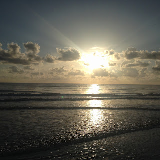
Obviously being curious the first thing I went to find was the best view of the launch facilities of the Kennedy Space Center from the dunes of Playinda Beach.


Playinda Beach is an undeveloped segment of the Atlantic Coast and the sands continue unabated north to Eldora and CR A1A.


There isn't much left of Wilson at the corner of CR 402 and Kennedy Parkway (former FL 3). Wilson was sometimes referred to as Wilson's Corner and had an extensive lumber yard. The junction of what was FL 402 and FL 3 remains at the north gate of the Kennedy Space Center.


This line that crossed on Kennedy Parkway used to carry lumber from Wilson

Allenhurst was located on Haulover Canal which allowed access from Indian River and Mosquito Lagoon. The area can be observed by the dirt roads that are accessible from Courtenay Parkway (again former FL 3) which are used for boat ramp access and manatee observation platforms. Allenhurst used to be primarily a sports fishing community, all the structures were razed due to being in the debris field radius of the Kennedy Space Center.


There was actually ruins to be found in Shiloh. A couple abandoned streets and parking lots weren't razed and are gradually being consumed by the onset of plant overgrowth.


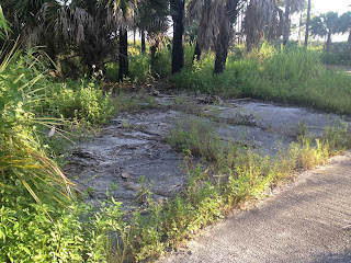


Taylor Road remains and can be used for boat ramp access.


Apparently Shiloh may be consumed for use in a Civilian Space Port as a measure in 2013 selected the area as a potential site. Apparently there was some sort of environmental red tape that caused a snag in 2014 which may allow the ruins of Shiloh to live on. Oddly Shiloh is the community that I know the least about that was razed due to the Kennedy Space Center.

On the 1956 State Highway of Florida shows a substantial difference in the area surrounding the Kennedy Space Center.
1956 Florida State Highway Map
- Florida State Road 3 is shown leaving US 1 from Oak Hill and traversing south through Shiloh, and Allenhurst before meeting FL 402 in Wilson. FL 3 continues south through Orsino to FL 520.
- A proposed extension of FL A1A is shown south of New Smyrna Beach to FL 402 at Playlinda Beach. As I mentioned last week when I discussed Canaveral National Seashore this part of the coast is completely undeveloped.
- FL A1A has a segment south from FL 402 to De Soto State Park which is no longer accessible to the public. The road grade of FL A1A actually seems to have been incorporated into launch pads of the Kennedy Space Center which can be seen by observing this current Google Maps Image.
https://www.google.com/maps/@28.6313758,-80.6263612,4563m/data=!3m1!1e3?hl=en
Obviously being curious the first thing I went to find was the best view of the launch facilities of the Kennedy Space Center from the dunes of Playinda Beach.


Playinda Beach is an undeveloped segment of the Atlantic Coast and the sands continue unabated north to Eldora and CR A1A.


There isn't much left of Wilson at the corner of CR 402 and Kennedy Parkway (former FL 3). Wilson was sometimes referred to as Wilson's Corner and had an extensive lumber yard. The junction of what was FL 402 and FL 3 remains at the north gate of the Kennedy Space Center.


This line that crossed on Kennedy Parkway used to carry lumber from Wilson

Allenhurst was located on Haulover Canal which allowed access from Indian River and Mosquito Lagoon. The area can be observed by the dirt roads that are accessible from Courtenay Parkway (again former FL 3) which are used for boat ramp access and manatee observation platforms. Allenhurst used to be primarily a sports fishing community, all the structures were razed due to being in the debris field radius of the Kennedy Space Center.


There was actually ruins to be found in Shiloh. A couple abandoned streets and parking lots weren't razed and are gradually being consumed by the onset of plant overgrowth.


Taylor Road remains and can be used for boat ramp access.


Apparently Shiloh may be consumed for use in a Civilian Space Port as a measure in 2013 selected the area as a potential site. Apparently there was some sort of environmental red tape that caused a snag in 2014 which may allow the ruins of Shiloh to live on. Oddly Shiloh is the community that I know the least about that was razed due to the Kennedy Space Center.
Comments