
Ukiah is a City and Mendocino County Seat located on the Redwood Highway of US Route 101. Before the current freeway US Route 101 was aligned through Ukiah on State Street. In this blog we examine the history of US Route 101, the Redwood Highway and other State Highways in/around the City of Ukiah.
Part 1; the history of US Route 101, Redwood Highway and State Highways in Ukiah
As noted above Ukiah is the Mendocino County Seat. Mendocino County was one of the original 1850 Counties created when California became an American State. At the time Mendocino County was administrated by neighboring Sonoma County due to the population of the former being too small. Mendocino County would become self governed until 1859 when it grew large enough not to be administered by Sonoma County.
Ukiah lies on land that was part of Rancho Yokaya of Mexican Alta California. The word "Yokaya" comes from the Pomo tribal word for "Deep Valley" and forms the basis of the City name of "Ukiah." What would become Ukiah was settled in 1856 when John Lowry constructed a cabin at what is now the corner of Main Street and East Perkins Street. Lowry's land claims were sold to A.T. Perkins in 1857 who subsequently moved his family to Ukiah. By 1858 Ukiah became large enough to merit Post Office Service and reached 100 residents by 1859. Ukiah due to it's relatively large population was subsequently selected as the original Mendocino County Seat in 1859. Despite being the Mendocino County Seat the community of Ukiah wouldn't incorporate as a City until March 8th, 1876.
Ukiah can be seen on the 1873 Bancroft's Road Map of California.

The history of what would become US Route 101 ("US 101") in Ukiah began with the approval of the 1909 First State Highway Bond Act. The First State Highway Bond Act was approved by voters during 1910 and was the genesis point of some of the most notable highways in California. Legislative Route Number 1 ("LRN 1") as originally plotted was a new State Highway which was designated between San Francisco north to Crescent City. The route of LRN 1 would be extended to the Oregon State Line during the 1919 Third State Highway Bond Act and was came be known as the Redwood Highway. The planned LRN 1 can be seen aligned through Ukiah on State Street on the 1917 California State Automobile Association Map.

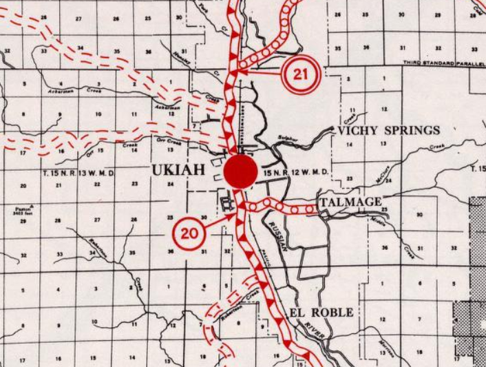
As part of the 1919 Third State Highway Bond Act LRN 1/Redwood Highway immediately north of Ukiah was selected as the new western terminus of the extended LRN 15. The Third State Highway Bond Act had extended LRN 15 west of Williams along the north shore of Clear Lake to the outskirts of Ukiah. LRN 15 terminating near Ukiah can be seen for the first time on the 1920 Division of Highways Map.

In 1925 LRN 70 between Ukiah and Mendocino State Hospital was adopted into the State Highway System. The original definition of LRN 70 was; "LRN 1 near Ukiah to the west line grounds of Mendocino State Hospital." LRN 70 according to CAhighways.org was stated to have originated from LRN 1/Redwood Highway 2,446 feet south of the Ukiah Town Limit in it's original definition along Talmage Road. LRN 70 can be first be seen on the 1926 Division of Highways State Map.


In November 1926 the US Route System was created. US Route 101 from San Francisco north to Crescent City was aligned over the Redwood Highway. Both US 101 and the Redwood Highway can be seen aligned through Willits on the 1927 Rand McNally Highway Map of California.

In the August 1934 California Highways and Public Works Guide the Sign State Routes were announced. CA 20 was applied to the entirety of LRN 15 which put it's western terminus at US 101/LRN 1 near Ukiah.


CA 20/LRN 15 can be seen terminating at US 101/LRN 1 via what is now Lake Mendocino Drive on the 1935 California Division of Highways Map of Mendocino County. LRN 70 can be seen south of downtown Ukiah following Talmage Road east from US 101/LRN 1 to Talmage.

The May/June 1957 California Highways & Public Works discusses the realignment of CA 20/LRN 15 north of Ukiah to make way for the Coyote Dam and Russian River Reservoir (Mendocino Lake Reservoir). The realignment of CA 20/LRN 15 is cited to be 4.2 miles in length would be 32 feet in width. The realignment of CA 20/LRN 15 was cited to have a opening date of no later than Marth 31st, 1958 due to anticipated inclement weather.


CA 20/LRN 15 was ultimately realigned north of Lake Mendocino which put it onto what effectively was a full bypass of Ukiah. The new alignment of CA 20/LRN 15 can be seen for the first time on the 1958 Division of Highways Map.

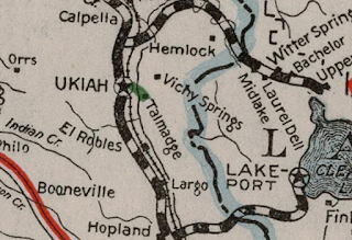
The July/August 1958 California Highways & Public Works notes that CA 20 was extended Ukiah to Fort Bragg via Willits in 1957. A citation notes Fort Bragg-Willits Road was significantly improved via a Federal Aid Secondary Program to State Standards.

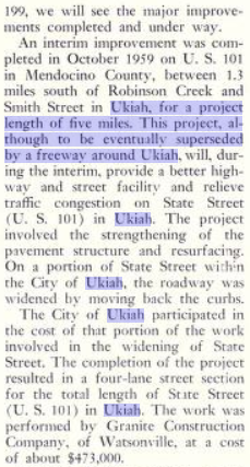
The November/December 1959 California Highways & Public Works discusses the widening of US 101 on State Street in downtown Ukiah. The widening of State Street was stated to be an interim measure to flow traffic on US 101 through downtown Ukiah more efficiently until the highway could be moved to a freeway bypass.

The November/December 1963 California Highways & Public Works notes that 5.2 miles of US 101/CA 20 north Ukiah were upgraded to a four lane freeway. The article notes that the construction contract for building US 101 to a freeway in Ukiah was awarded in September 1963.

According to CAhighways.org CA 253 was added to the State Highway System during 1963 Legislative Chapter 2155. Given that CA 253 was added by the Legislature in the run up to the 1964 State Highway Renumbering it never had a Legislative Route Number. CA 253 first appears as a planned State Highway on the 1964 Division of Highways Map. The planned route of CA 253 appears north of the existing Ukiah-Boonville Road. CA 253's original route definition was "from Route 128 near Boonville to Route 101 near Ukiah." Note; LRN 70 was assigned CA 222 as part of the 1964 State Highway Renumbering.


The November/December 1964 California Highways & Public Works cites that a freeway segment of US 101 south of Ukiah had recently been completed. The freeway alignment of US 101 through Ukiah is cited to have a planned opening during Fall of 1965.

The November/December 1965 California Highways & Public Works cites US 101 as having been realigned onto the Ukiah Bypass freeway alignment.


Subsequently US 101 appears as a freeway through Ukiah on the 1966 Division of Highways Map.

Part 2; a drive on former US Route 101 on State Street in Ukiah
Our tour of former US 101 on State Street through Ukiah begins north of the City Limits at the modern US 101 freeway Exit (552) at Lake Mendocino Drive.

The western segment of Lake Mendocino Drive was not part of CA 20 but rather was an extension built to connect to the freeway alignment of US 101. Lake Mendocino Drive east of State Street was the original alignment of CA 20 as noted in Part 1. From Lake Mendocino Drive our tour turns south onto former US 101 on State Street.

State Street continues southward, crosses under the modern US 101 freeway and enters the City of Ukiah.


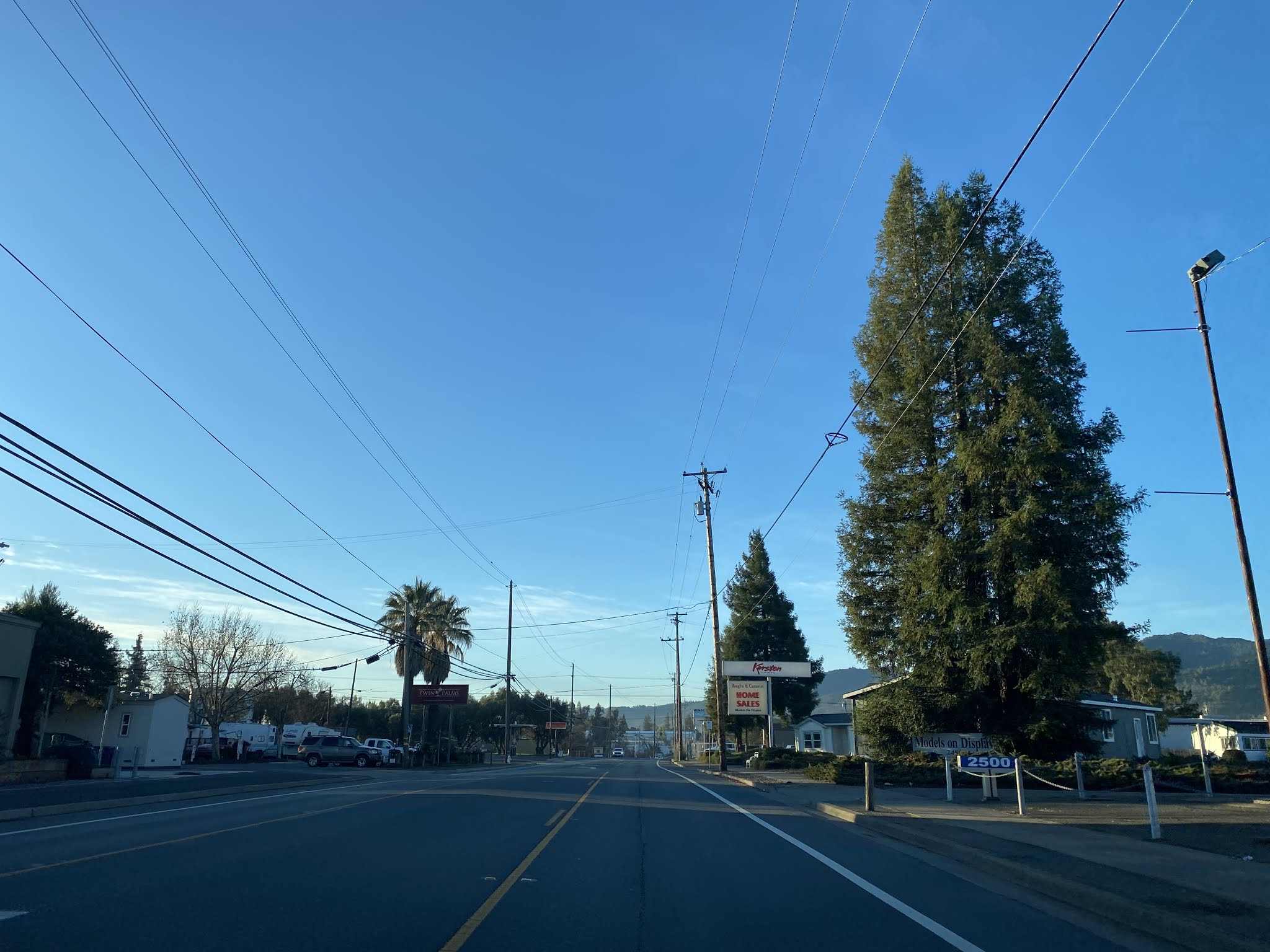


Former US 101 south on State Street passes through downtown Ukiah.


South of downtown Ukiah former US 101 on State Street intersects former CA 222/LRN 70 at Talmage Road. CA 222 now begins to the east at US 101 Exit 548A.


At Jefferson Lane former US 101 on State Street leaves the City Limit of Ukiah. At US 101 Exit 546 State Street carries a brief stub of CA 253 which splits west on Boonville-Ukiah Road. State Street ends at a ramp to the modern US 101 freeway.


Comments