
Former US Route 101 at Confusion Hill


Since 1949 Confusion Hill has been a major roadside attraction for travelers along US Route 101 and Redwood Highway.  Confusion Hill is located on the South Fork Eel River watershed of Mendocino County.  Confusion Hill was part of mainline US Route 101 until 2009 when the highway was shifted onto the Confusion Hill Bridges.   


Part 1; the history of US Route 101 and Redwood Highway at Confusion Hill

The history of what would become US Route 101 ("US 101") at Confusion Hill begins with the approval of the 1909 First State Highway Bond Act.  The First State Highway Bond Act was approved by voters during 1910 and was the genesis point of some of the most notable highways in California.  Legislative Route Number 1 ("LRN 1") as originally plotted was a new State Highway which was designated between San Francisco north to Crescent City.  The route of LRN 1 would be extended to the Oregon State Line during the 1919 Third State Highway Bond Act and was came be known as the Redwood Highway.  The planned LRN 1 can be seen aligned between 
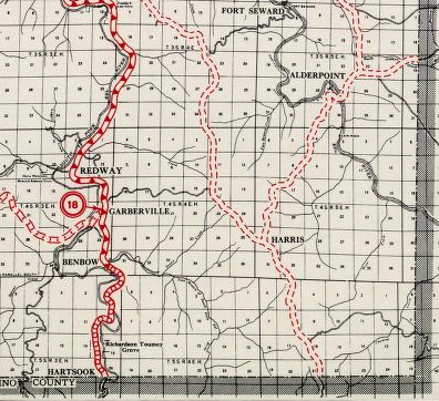
Garberville of Humboldt County and Cummings of Mendocino County on the 1917 California State Automobile Association Map.

Prior to the construction of LRN 1 wagon borne traffic heading north from Cummings to Humboldt County had to ascend the treacherous Rattlesnake Grade (also known as the Bell Springs Grade).  The Rattlesnake Grade is described in the October 1912 California Highway Bulletin as being only passable during the summer months.  The initial northward climb on the Rattlesnake Grade ascended slopes as high as 20% the from Cummings to the 4,100 foot high Bell Springs Mountain.  The descent from Bell Mountain to Dyerville (on CA 254/Avenue of the Giants) is described as having grades as steep as 30% amid an elevation drop of just over 3,900 feet.  The construction of LRN 1 (then known as the Mendocino State Highway) sought to follow the South Fork Eel River watershed to bypass the Rattlesnake Grade.  Note; the Rattlesnake Grade can be seen above on the 1917 California State Automobile Association Map between Cummings and Dyerville. 


Much of the Rattlesnake Grade still exists as modern Bell Springs Road.   The Rattlesnake Grade can be seen in detail between Garberville-Cummings on the 1935 Division of Highways Maps of Humboldt County and Mendocino County


The completed Redwood Highway/LRN 1 between Cummings and Garberville can be seen on the 1920 Clason Highway Map of California.  The replacement of the Rattlesnake Grade with the new alignment of the Redwood Highway/LRN 1 was of such a scale that it rivaled the likes of other First State Highway Bond Act roads the Old Ridge Route (LRN 4). 

In November 1926 the US Route System was created.  US Route 101 from San Francisco north to Crescent City was aligned over the Redwood Highway.  Both US 101 and the Redwood Highway between Garberville and Cummings can be seen on the 1927 Rand McNally Highway Map of California.

A new segment of the Redwood Highway between Piercy and Rock Creek can be seen in the October 1926 California Highways & Public Works just prior to it becoming US 101.   

The future site of Confusion Hill can be seen south of the confluence of the South Fork Eel River and Red Mountain Creek on the 1935 Division of Highways Map of Mendocino County.  


As noted in the intro Confusion Hill was opened in 1949 as an attraction oriented towards optical illusion displays.  Confusion Hill was the creation of George Hudson who took inspiration from the Oregon Vortex and Santa Cruz Mystery Spot after returning from World War II.  More regarding the history of Confusion Hill can be found on the Confusion Hill website.  

The Gravity House of Confusion Hill can be seen in this undated vintage post card. 


During the 1964 Christmas Floods US 101 between Garberville-Cummings saw substantial damage.  The January-February 1965 California Highways & Public Works cited that US 101 near Leggett largely eroded down into the South Fork Eel River.  

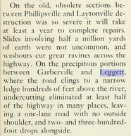
The March-April 1965 California Highways & Public Works cites that slides occurred on US 101 at; Leggett, Piercy, Richardson Grove, and Cummings during the 1964 Christmas Floods. 

The Garberville-Cummings segment of US 101 initially remained mostly unchanged after the 1964 Christmas Floods which is evident on the 1967 Division of Highways State Map

US 101 is shown as an expressway south of Garberville to the vicinity of Richardson Grove State Park on the 1969 Division of Highways State Map.  US 101 is shown to have a planned bypass route of Richardson Grove State Park which shown continuing to an existing expressway segment near Cummings.  

The 1970 Division of Highways State Map shows the Richardson Grove bypass under construction, ultimately it never would be completed. 


US 101 through Confusion Hill appears to have been planned to be recycled into California State Route 271 ("CA 271").  According to CAhighways.org CA 271 was given the following somewhat vague definition by 1970 Legislative Chapter 1473:
 
“Route 101 near Cummings to Route 101 near the Humboldt-Mendocino county line.”
 
The 1977 Caltrans State Map no longer shows the planned US 101 bypass of Richardson Grove suggesting it was cancelled.  Notably the north and south segments of CA 271 are shown as being present (as evidenced by US 101 being an expressway through Piercy) along with an unbuilt planned realignment between Piercy-Leggett.  The Piercy-Leggett realignment of US 101 had it been constructed would have likely filled the gap between the north and south segments of CA 271 and would have seen Confusion Hill on an Avenue of the Giants-like scenic alternate highway.  

 
According to CAhighways.org US 101 immediately north of Confusion Hill was infamously prone to slides.  The realignment of US 101 onto a bypass of Confusion Hill required construction of two new bridges over the South Fork Eel River.  The decade long project to replace US 101 north of Confusion Hill was realized in October of 2009 when the Confusion Hill Bridges were fully opened to traffic.  Upon the opening the Confusion Hill Bridges the original alignment of US 101 was removed per FHWA guidelines.  The scar of the original alignment of US 101 north of Confusion Hill towards Red Mountain Creek is obvious on Google Satellite images.  
 

The slide zone north of Confusion Hill along with the original grade of US 101 up close. 
 
 
This image from Bridgehunter.com shows the Confusion Hill Northern Bypass Bridge from the original grade of US 101.  The Confusion Hill Northern Bypass Bridge is a 531 foot long box girder design.  


This image from Bridgehunter.com shows the Confusion Hill Southern Bypass Bridge from the original grade of US 101.  The Confusion Hill Southern Bypass Bridge is a 1,395 foot long box girder design.


Part 2; a visit to Confusion Hill

Notably Confusion Hill still shows up in the Caltrans Postmile Tool as Route 101U MEN 99.493.  The "U" suffix in the Postmile Tool denotes that the Confusion Hill lies on an unreliquished segment of US 101.  Route 101U near Confusion Hill shows with a Postmile range of MEN 99.431 to MEN 100.457.  The former alignment of US 101 is likely retained by Caltrans to mitigate the slide seen in the satellite image above and incorporates Rosewarne Road near Red Mountain Creek.  


Looking north on Route 101U in front of Confusion Hill towards the slide area shown in the satellite images in Part 1.  


Looking south on Route 101U in front of Confusion Hill towards modern US 101.  


The totem pole in front of Confusion Hill.


The Confusion Hill Shoe House.  


The traditional entrance to Confusion Hill.


The Minnie Stoddard Lilley Memorial can found at the entrance of Confusion Hill.  Minnie Stoddard Lilley and her husband William Lilley were responsible for opening The World Famous Treehouse which was built in a hollow of the 301 foot tall Fraternal Monarch Tree.


The entrance to Confusion Hill now is located in the gift shop building.  


The Chipalope's Tale can be found behind the gift shop building.  The Chipalope is something of a mascot figure to Confusion Hill.  


A statement on what to expect at Confusion Hill as written by George Hudson in 1949.  


A height variation slab display.


The entrance to the Gravity House.


My wife accidentally demonstrating the optical illusion of the Gravity House.  


The Gravity House without any visual obstructions (no people). 


Another optical illusion display.  


The highway readers of this blog will appreciate this Tsunami Evacuation route.  


The history of Confusion Hill presented on a sign which displays an Interstate shield as opposed to a US Route shield.  


The Northern Mendocino Pet Rock Prison. 


100% guaranteed to be right at least 99% of the time.  


Comments

Popular posts from this blog

US Route 62 and US Route 180 in the Guadalupe Mountains

US Route 62/US Route 180 between El Paso, Texas and Carlsbad, New Mexico passes through the Guadalupe Mountains.  The Guadalupe Mountains comprise the highest peaks of Texas which are largely protected as part Guadalupe Mountains National Park.  The automotive highway through the Guadalupe Mountains was constructed in the late 1920s as part of Texas State Road 54.  US Route 62 was extended from Carlsbad through the Guadalupe Mountains to El Paso during 1932.  US Route 62 was joined in the Guadalupe Mountains by US Route 180 in 1943.  The Guadalupe Mountains comprise a portion of the 130 mile "No Services" zone on US Route 62/US Route 180 between El Paso-Carlsbad. Part 1; the history of US Route 62 and US Route 180 in the Guadalupe Mountains The Guadalupe Mountains lie within the states of Texas and New Mexico.  The Guadalupe Mountains essentially is a southern extension of the larger Rocky Mountains.  The Guadalupe Mountains is the highest range in Texas with the peak elevati

Paper Highways; unbuilt California State Route 100 in Santa Cruz

This edition of Paper Highways examines the unbuilt California State Route 100 in Santa Cruz. The History of Unbuilt California State Route 100 The route that became CA 100 was added to the State Inventory in 1959 as part of the Freeway & Expressway System as Legislative Route 287 .  According to CAhighways.org the initial definition of LRN 287 had it begin at LRN 5 (CA 17) and was defined over the below alignment to LRN 56 (CA 1) through downtown Santa Cruz. -  Ocean Street -  2nd Street -  Chestnut Street For context the above alignment would required tearing down a large part of the densely populated Santa Cruz.  A modern Google imagine immediately reveals how crazy an alignment following Ocean Street, 2nd Street, and Chestnut Street would have been. LRN 287 first appears on the 1960 Division of Highways State Map . In 1961 the definition of LRN 287 was generalized to; from LRN 5 via the beach area in Santa Cruz to LRN 56 west of the San Lorenzo River. 

New Mexico State Road 7 (Carlsbad Caverns Highway)

New Mexico State Road 7 is approximately a seven-mile highway in the Guadalupe Mountains of Eddy County. New Mexico State Road 7 connects US Route 62/US Route 180 at Whites City to the visitor center of Carlsbad Caverns National Park via Walnut Canyon. The so-called Carlsbad Caverns Highway to the National Park visitor center complex was constructed following the designation of the namesake National Monument in 1923. The current iteration of New Mexico State Road 7 was designated by the New Mexico State Highway Commission during June 1929. A proposal once was once floated to connect New Mexico State Road 7 to a cavern drive which would have been blasted into Big Room. Part 1; the history of New Mexico State Road 7 What are now Carlsbad Caverns was explored in the Guadalupe Mountains of Eddy County by local Jim White during 1898.  White explored the caverns via a homemade ladder and named several of the more notable rooms.  The name "Carlsbad Caverns" was derived from the