Upon leaving the near ghost town of Silver Plume I headed east on US 6/I-70 further into Clear
Creek Canyon. My next destination was close by at much more lively
Georgetown.

This article serves as the 31st entry in the 2016 Summer Mountain Trip Series. Part 30 regarding former US 6 and CO 91 in Silver Plume can be found below:
2016 Summer Mountain Trip Part 30; former US Route 6 and Colorado State 91 in Silver Plume
As noted in Part 29 and Part 30 Loveland Pass is one of the oldest transportation corridors through the Rockies. Loveland Pass traces it's origins back to a wagon road constructed through Clear Creek Canyon by William A.H. Loveland in 1863-1864. The Loveland wagon road up Clear Creek Canyon to Loveland Pass was built to take advantage of the numerous mining stamp mills that popped up during the Pikes Peak Gold Rush.
Georgetown was founded in 1859 during the Pikes Peak Gold Rush by George and David Griffith out of Kentucky. The name "Georgetown" was taken in honor of the older George Griffith. Georgetown notably was founded during the Pikes Peak Gold Rush but grew rapidly upon the discovery of silver during September 1864 in a canyon south of Argentine Pass. By 1880 the population of Georgetown would ascend to over 3,000 residents.
By 1879 the Colorado Central Railroad became interested extending the line from Georgetown west through Silver Plume to Leadville. The solution to solve the 6% grades of Clear Creek Canyon was to reduce the grade to 3% by use of heavy switchbacks. This series of switchbacks and curves would come to be known as the Georgetown Loop. The Georgetown Loop was complete by 1884 which is when the first trains in Silver Plume began to arrive. The Georgetown Loop and Colorado Central ultimately would only make it a couple miles west of Silver Plume.
During the Auto Trail era in Colorado the road over Loveland Pass by way of Georgetown and Silver Plume appeared not to be a major corridor of travel. No signed highways appear over Georgetown, Silver Plume, and Loveland Pass on the 1924 Rand McNally Regional Highway Map. The Midland-Roosevlt Midland Trail is shown to climb out of Clear Creek Canyon via Berthoud Pass (future US 40) via Empire.

Georgetown, Silver Plume, and Loveland Pass appears on the route of CO 91 on the 1927 Rand McNally Highway Map of Colorado. CO 91 in it's original form began at US 40S in Leadville. CO 91 from Leadville headed northeast via Fremont Pass and Loveland Pass to US 40/CO 2 in Empire. CO 91 was aligned on what is now Loop Drive and Argentine Street through Georgetown.

During the 1930s US 40 through clear Creek Canyon was improved which is evidenced by bridge work on Colorado Boulevard in Idaho Springs having date stamps of "1931." By 1937 US 6 was extended from Greeley, CO to Long Beach, CA according to USends. US 6 absorbed the entire route of CO 91 which aligned it through Georgetown, Silver Plume, Loveland Pass, and Fremont Pass which can be seen on the 1939 State Farm Insurance Map of Colorado. By 1940 US 6 would be rerouted from Fremont Pass to Vail Pass but Loveland Pass would remain as part of the highway. US 6 would remain on Loop Drive and Argentine Street until it was shifted onto a multiplex with I-70.

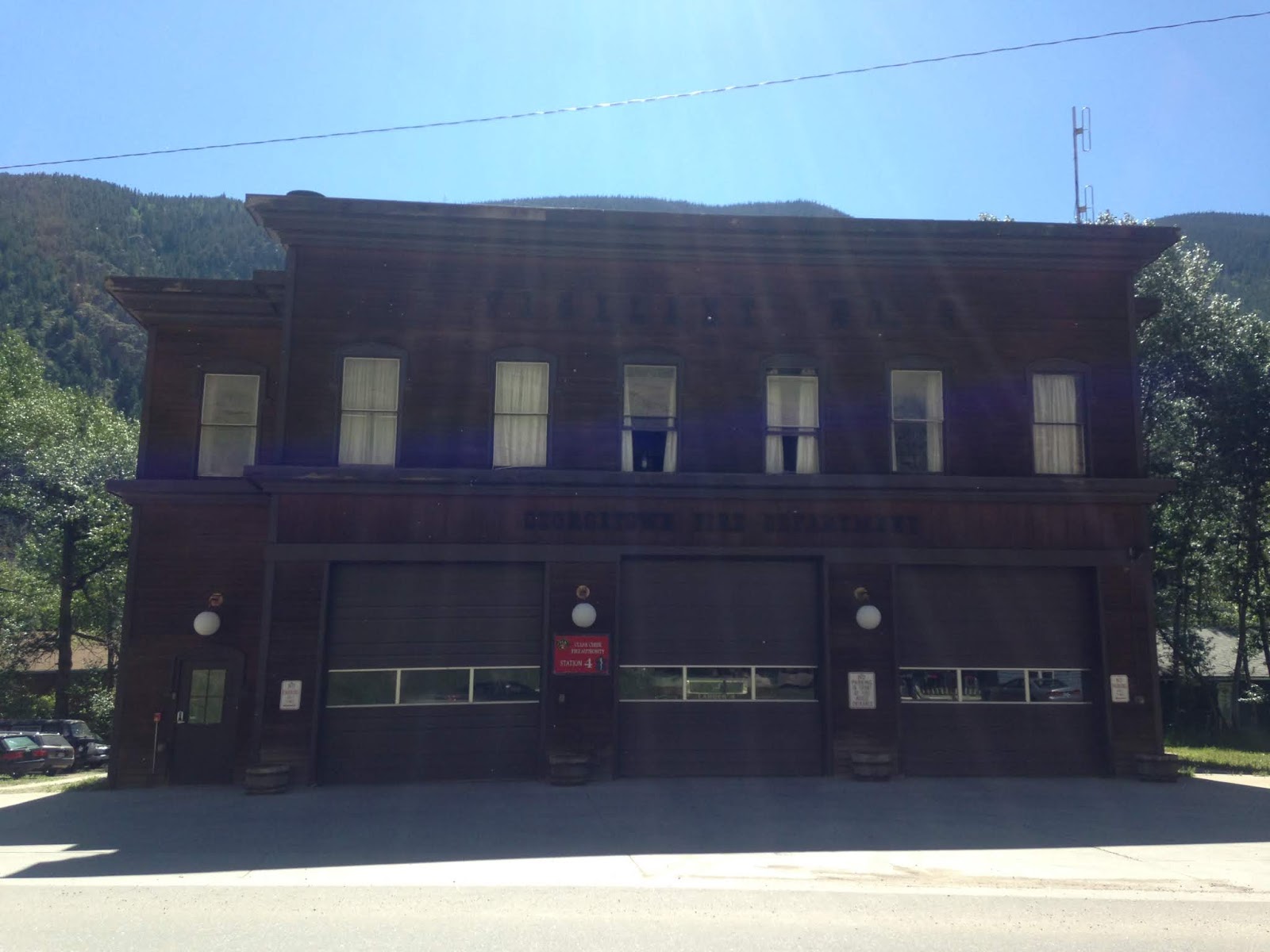
My walking tour of Georgetown began just off of former US 6 on Brownell Street at the Georgetown Fire Department building. I entered Georgetown via US 6/I-70 Exit 228.

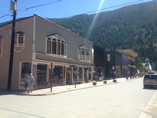
A look east on Sixth Street near the intersection of Argentine Street.

Some of the street scenery on Sixth Street.


The notable Hotel de Paris is located on 6th Street between Taos Street and Griffith Street. The Hotel de Paris opened during 1875 and was once famous for it's French oriented dining.


Some various street scenes in Georgetown.


The Buckley Garage located at the corner of Rose Street and Seventh Street is adorned with an older Conoco marque.

Upon leaving Georgetown I returned to US 6/I-70 eastbound. My next stop was in downtown Idaho Springs.
2016 Summer Mountain Trip Part 32; former US Route 40 in Idaho Springs

This article serves as the 31st entry in the 2016 Summer Mountain Trip Series. Part 30 regarding former US 6 and CO 91 in Silver Plume can be found below:
2016 Summer Mountain Trip Part 30; former US Route 6 and Colorado State 91 in Silver Plume
As noted in Part 29 and Part 30 Loveland Pass is one of the oldest transportation corridors through the Rockies. Loveland Pass traces it's origins back to a wagon road constructed through Clear Creek Canyon by William A.H. Loveland in 1863-1864. The Loveland wagon road up Clear Creek Canyon to Loveland Pass was built to take advantage of the numerous mining stamp mills that popped up during the Pikes Peak Gold Rush.
Georgetown was founded in 1859 during the Pikes Peak Gold Rush by George and David Griffith out of Kentucky. The name "Georgetown" was taken in honor of the older George Griffith. Georgetown notably was founded during the Pikes Peak Gold Rush but grew rapidly upon the discovery of silver during September 1864 in a canyon south of Argentine Pass. By 1880 the population of Georgetown would ascend to over 3,000 residents.
By 1879 the Colorado Central Railroad became interested extending the line from Georgetown west through Silver Plume to Leadville. The solution to solve the 6% grades of Clear Creek Canyon was to reduce the grade to 3% by use of heavy switchbacks. This series of switchbacks and curves would come to be known as the Georgetown Loop. The Georgetown Loop was complete by 1884 which is when the first trains in Silver Plume began to arrive. The Georgetown Loop and Colorado Central ultimately would only make it a couple miles west of Silver Plume.
During the Auto Trail era in Colorado the road over Loveland Pass by way of Georgetown and Silver Plume appeared not to be a major corridor of travel. No signed highways appear over Georgetown, Silver Plume, and Loveland Pass on the 1924 Rand McNally Regional Highway Map. The Midland-Roosevlt Midland Trail is shown to climb out of Clear Creek Canyon via Berthoud Pass (future US 40) via Empire.

Georgetown, Silver Plume, and Loveland Pass appears on the route of CO 91 on the 1927 Rand McNally Highway Map of Colorado. CO 91 in it's original form began at US 40S in Leadville. CO 91 from Leadville headed northeast via Fremont Pass and Loveland Pass to US 40/CO 2 in Empire. CO 91 was aligned on what is now Loop Drive and Argentine Street through Georgetown.

During the 1930s US 40 through clear Creek Canyon was improved which is evidenced by bridge work on Colorado Boulevard in Idaho Springs having date stamps of "1931." By 1937 US 6 was extended from Greeley, CO to Long Beach, CA according to USends. US 6 absorbed the entire route of CO 91 which aligned it through Georgetown, Silver Plume, Loveland Pass, and Fremont Pass which can be seen on the 1939 State Farm Insurance Map of Colorado. By 1940 US 6 would be rerouted from Fremont Pass to Vail Pass but Loveland Pass would remain as part of the highway. US 6 would remain on Loop Drive and Argentine Street until it was shifted onto a multiplex with I-70.

My walking tour of Georgetown began just off of former US 6 on Brownell Street at the Georgetown Fire Department building. I entered Georgetown via US 6/I-70 Exit 228.
A look east on Sixth Street near the intersection of Argentine Street.

Some of the street scenery on Sixth Street.


The notable Hotel de Paris is located on 6th Street between Taos Street and Griffith Street. The Hotel de Paris opened during 1875 and was once famous for it's French oriented dining.


Some various street scenes in Georgetown.


The Buckley Garage located at the corner of Rose Street and Seventh Street is adorned with an older Conoco marque.

Upon leaving Georgetown I returned to US 6/I-70 eastbound. My next stop was in downtown Idaho Springs.
2016 Summer Mountain Trip Part 32; former US Route 40 in Idaho Springs
Comments