Crossing the Sierras westward from Donner Pass found me on Interstate 80. Given that I had a substantial jog of freeway ahead headed back to the Fresno area I decided to take a detour onto California State Route 20 westward to CA 174 in Grass Valley.

CA 20 is a long somewhat rural east/west State Highway at 212 miles which begins at I-80 in Nevada County and terminates at CA 1 in Mendocino County. All of CA 20 was part of Legislative Route Number 15 which was dates back as early as the 1909 First State Highway Bond with a 8.7 mile segment from Williams to Colusa. In 1919 LRN 15 was greatly expanded during the Third State Highway Bond which stretched from Ukiah at modern day US Route 101 east to Emigrant Gap at LRN 37 at the Dutch Flat & Donner Lake Road. In 1934 all of LRN 15 was assigned CA 20 as a Signed Route Number.
CAhighways.org Highway History Chapter 1
CAhighways.org Highway History Chapter 2
The original extent of CA 20 can be viewed on the 1938 State Highway Map.
1938 State Highway Map
LRN 15 was extended to CA 1 in 1953 during Legislative Chapter 1408.
CAhighways.org on CA 20
The unbuilt extension of LRN 15 can be viewed between Willits at US 101 and Fort Bragg on the 1954 State Highway Map.
1954 State Highway Map
Ultimately a new alignment for LRN 15 was not built and CA 20 was applied to existing roadways between US 101 and CA 1 which can be seen on the 1958 State Highway Map.
1958 State Highway Map
My approach to CA 20 westbound to CA 174 was from Interstate 80 exit 161. Exit 161 is actually located a couple miles east of Emigrant Gap at the location of a former Central Pacific rail siding known as Yuba Pass. Yuba Pass is named after the nearby Yuba Gap which is was part of the wagon route over the Sierras traversed by the Dutch Flat & Donner Lake Road and is now occupied by I-80.


CA 174 is located 31 miles to the west on CA 20 in Grass Valley.

CA 20 briefly dips southward into Placer County and the Emigrant Gap. Emigrant Gap was part of the traditional crossing of the Sierras west from Donner Pass. The Emigrant Gap is a notable drop in the terrain at roughly 5,200 feet where wagon parties would need to lower their wagons by rope. The first wagon crossing of the Emigrant Gap was by the Stephens-Townsend-Murphy Party in 1845 as they descended the Sierras from Donner Pass.


CA 20 dips north across the Bear River from Emigrant Gap which serves the Nevada County line.


CA 20 west to Nevada City at CA 49 is signed as a Scenic Route.

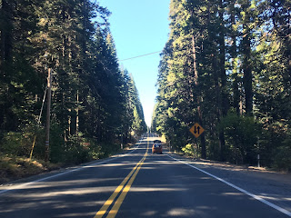
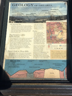
CA 20 is a curvy highway but well graded. After a series of wide curves there is a vista along CA 20 of the Omega and Alpha Hydraulic Mines. The Omega and Alpha Mines were named after towns that were formed in the mid-1850s. The hydraulic mining eventually consumed both Omega and Alpha but the mining pits in addition to tailings are still evidence. The Omega Mine operated until 1949.


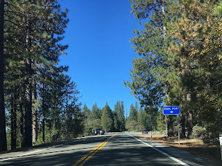
West of the Omega and Alpha Mine overlook is another vista on CA 20 of Washington Ridge. Below Washington Ridge is the community of Washington on the South Fork Yuba River. Washington is one of the Traditional California Gold Rush communities having been settled in 1849. There is a small monument at the overlooking detailing the history of the Nevada and Washington Toll Road which is now occupied by the right-of-way of CA 20.


CA 20 gradually drops to approximately 3,000 feet above sea level westward to CA 49 in Nevada City.


CA 20 multiplexes CA 49 onto a freeway alignment and enters Grass Valley.


CA 20/49 has a junction with CA 174 in Grass Valley. I pulled off the CA 20/49 freeway to join CA 174.


CA 20 is a long somewhat rural east/west State Highway at 212 miles which begins at I-80 in Nevada County and terminates at CA 1 in Mendocino County. All of CA 20 was part of Legislative Route Number 15 which was dates back as early as the 1909 First State Highway Bond with a 8.7 mile segment from Williams to Colusa. In 1919 LRN 15 was greatly expanded during the Third State Highway Bond which stretched from Ukiah at modern day US Route 101 east to Emigrant Gap at LRN 37 at the Dutch Flat & Donner Lake Road. In 1934 all of LRN 15 was assigned CA 20 as a Signed Route Number.
CAhighways.org Highway History Chapter 1
CAhighways.org Highway History Chapter 2
The original extent of CA 20 can be viewed on the 1938 State Highway Map.
1938 State Highway Map
LRN 15 was extended to CA 1 in 1953 during Legislative Chapter 1408.
CAhighways.org on CA 20
The unbuilt extension of LRN 15 can be viewed between Willits at US 101 and Fort Bragg on the 1954 State Highway Map.
1954 State Highway Map
Ultimately a new alignment for LRN 15 was not built and CA 20 was applied to existing roadways between US 101 and CA 1 which can be seen on the 1958 State Highway Map.
1958 State Highway Map
My approach to CA 20 westbound to CA 174 was from Interstate 80 exit 161. Exit 161 is actually located a couple miles east of Emigrant Gap at the location of a former Central Pacific rail siding known as Yuba Pass. Yuba Pass is named after the nearby Yuba Gap which is was part of the wagon route over the Sierras traversed by the Dutch Flat & Donner Lake Road and is now occupied by I-80.


CA 174 is located 31 miles to the west on CA 20 in Grass Valley.

CA 20 briefly dips southward into Placer County and the Emigrant Gap. Emigrant Gap was part of the traditional crossing of the Sierras west from Donner Pass. The Emigrant Gap is a notable drop in the terrain at roughly 5,200 feet where wagon parties would need to lower their wagons by rope. The first wagon crossing of the Emigrant Gap was by the Stephens-Townsend-Murphy Party in 1845 as they descended the Sierras from Donner Pass.


CA 20 dips north across the Bear River from Emigrant Gap which serves the Nevada County line.


CA 20 west to Nevada City at CA 49 is signed as a Scenic Route.

CA 20 is a curvy highway but well graded. After a series of wide curves there is a vista along CA 20 of the Omega and Alpha Hydraulic Mines. The Omega and Alpha Mines were named after towns that were formed in the mid-1850s. The hydraulic mining eventually consumed both Omega and Alpha but the mining pits in addition to tailings are still evidence. The Omega Mine operated until 1949.


West of the Omega and Alpha Mine overlook is another vista on CA 20 of Washington Ridge. Below Washington Ridge is the community of Washington on the South Fork Yuba River. Washington is one of the Traditional California Gold Rush communities having been settled in 1849. There is a small monument at the overlooking detailing the history of the Nevada and Washington Toll Road which is now occupied by the right-of-way of CA 20.


CA 20 gradually drops to approximately 3,000 feet above sea level westward to CA 49 in Nevada City.


CA 20 multiplexes CA 49 onto a freeway alignment and enters Grass Valley.


CA 20/49 has a junction with CA 174 in Grass Valley. I pulled off the CA 20/49 freeway to join CA 174.


Comments