
Earlier this month, I head up north with Joe Babyak and met up with Doug Kerr to explore New England. It was a great trip and the weather somewhat cooperated (more on that in the days to come). The first part of the trip was going from Raleigh, NC to Schenectady, NY.
Our Route: US 64, I-95, I-495, I-270, US 15, PA 581, I-81, US 22/322, US 11/15, US 15, I-86, NY 13, NY 79, NY 206, I-288, NY 7, NY 337 into Schenectady.
We took this route so I could pick up a few more counties...and I did pick up one in PA (Tioga) and two in New York (Schyler and Tompkins). It was also the first time I took US 11/15 through the central part of the state north of Harrisburg. And I really enjoyed the drive. The US 15 freeway (Future Interstate 99) north of Williamsport is very impressive and may be the most scenic freeway in Pennsylvania.
Photos from this leg of the trip can be found here.
Our first real stop wasn't until just south of Ithaca, NY. Just off of NY 13 in the town of Newfield is a covered bridge. The bridge was built in 1853 and underwent a refurbishing project about ten years ago. There is a small park that sits next to the bridge and along the West Branch of Cayuga Creek.
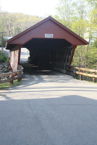
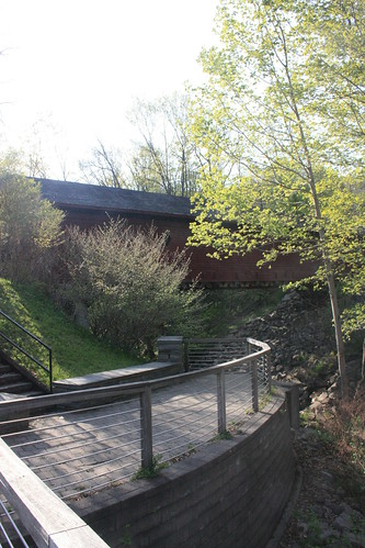
Unfortunately, we didn't visit the bridge at the best time of day as you can tell from the glare in the photos.
Our other stop was on Doug's suggestion which is the waterfall at Buttermilk Falls State Park in Ithaca. The falls are easy to visit as it sits just off of NY 13.
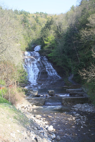
Oh, how I wish I had brought my tripod this trip.
The park has a number of hiking trails as well that run along the gorge. Campsites are also at the park. Ithaca is home to a number of gorges and waterfalls. Doug has pretty much photographed all of them. During all four seasons, too.
That's it for Day 1. Would loved to have stopped in Greene, NY for a bit, but we were hungry and pressed for time. Getting up at 5:30-6 am the next day was going to be rough.
Our Route: US 64, I-95, I-495, I-270, US 15, PA 581, I-81, US 22/322, US 11/15, US 15, I-86, NY 13, NY 79, NY 206, I-288, NY 7, NY 337 into Schenectady.
We took this route so I could pick up a few more counties...and I did pick up one in PA (Tioga) and two in New York (Schyler and Tompkins). It was also the first time I took US 11/15 through the central part of the state north of Harrisburg. And I really enjoyed the drive. The US 15 freeway (Future Interstate 99) north of Williamsport is very impressive and may be the most scenic freeway in Pennsylvania.
Photos from this leg of the trip can be found here.
Our first real stop wasn't until just south of Ithaca, NY. Just off of NY 13 in the town of Newfield is a covered bridge. The bridge was built in 1853 and underwent a refurbishing project about ten years ago. There is a small park that sits next to the bridge and along the West Branch of Cayuga Creek.
Unfortunately, we didn't visit the bridge at the best time of day as you can tell from the glare in the photos.
Our other stop was on Doug's suggestion which is the waterfall at Buttermilk Falls State Park in Ithaca. The falls are easy to visit as it sits just off of NY 13.
Oh, how I wish I had brought my tripod this trip.
The park has a number of hiking trails as well that run along the gorge. Campsites are also at the park. Ithaca is home to a number of gorges and waterfalls. Doug has pretty much photographed all of them. During all four seasons, too.
That's it for Day 1. Would loved to have stopped in Greene, NY for a bit, but we were hungry and pressed for time. Getting up at 5:30-6 am the next day was going to be rough.
Comments
What may be the second most scenic freeway in PA is US 322 between Harrisburg and State College (and continuing south on I-99 from State College to about Tyrone is a good extension to that drive). Mountain passes, river gorges, changes of elevation, and many miles of terraced freeway. Gorgeous anytime, but especially in the fall.