California State Route 41 north from the Kings County/Fresno County Line at Excelsior Avenue to Postmile FRE 6.00 at Elkhorn Avenue consists of substandard two lane expressway serving as a gap from two modern four lane facilities. In recent months the Excelsior Avenue-Elkhorn Avenue segment of California State Route 41 has obtained infamy due to it's high number of accidents which led to the corridor obtaining the nickname of "The 2 Lane Death Trap." As of August 7th, 2021 the Excelsior Avenue-Elkhorn Avenue segment of California State Route 41was converted to the first centerline K-Rail barrier two lane State Highway in Caltrans District 6.
Part 1; the history of The 2 Lane Death Trap corridor of California State Route 41As noted in the Gribblenation Blog titled "Old California State Route 41 in southern Fresno County" the segment of highway from Excelsior Avenue north to Elkhorn Avenue was added to the State Highway System in 1933 as part of Legislative Route Number 125 ("LRN 125"). As originally plotted LRN 125 ran north from Lemoore in Kings County north via 19th 1/2 Avenue to Excelsior Avenue at the Fresno County Line. LRN 125 northbound jogged briefly easterly on Excelsior Avenue to Elm Avenue. LRN 125 would follow Elm Avenue northward to Elkhorn Avenue. LRN 125 followed another brief eastward jog to a second segment of Elm Avenue which it followed north to the City of Fresno. LRN 125 between Lemoore and Fresno would be assigned as part of California State Route 41 ("CA 41") when the Sign State Routes were announced in the August 1934 California Highways & Public Works.
CA 41 can be seen on the
1935 Division of Highways Map of Fresno County aligned on Elm Avenue north from Excelsior Avenue (shown as Parkhurst Avenue) via Camden to Elkhorn Avenue (shown as Dodge Avenue).
The State Highway network around Lemoore began to see major modernization efforts following the construction of Naval Air Station Lemoore in 1961. Both CA 198 and CA 41 largely slated to be modernized within the vicinity of Lemoore either to freeway or expressway standards. By 1964 a two lane expressway segment of CA 41 was built via a diagonal line from Excelsior Avenue north to Elkhorn Avenue. This diagonal two lane expressway grade of CA 41 bisected the former alignment of Elm Avenue and reconnected back to it at Elkhorn Avenue. The new diagonal two lane expressway would serve as the beginning of a four lane expressway which would eventually bypass Lemoore and connect to the CA 198 freeway by 1998. The
1965 Division of Highways Map displays the new Excelsior Avenue-Elkhorn Avenue alignment of CA 41.
In 2004
CA 41 south from the Fresno City Limit to Elkhorn Avenue was completed to four lane expressway standards. The Excelsior Avenue-Elkhorn Avenue segment of CA 41 would remain a two-lane expressway connecting to the second four lane segment approaching Lemoore. The two-lane Excelsior Avenue-Elkhorn Avenue segment of CA 41 would subsequently become a choke point for the increasing traffic traveling from Fresno and Lemoore. The expanded expressway segment of CA 41 south of Fresno can be seen on the
2005 Caltrans State Map.
The Excelsior Avenue-Elkhorn Avenue segment of CA 41 would become a major choke point and was particularly hazardous during Tule Fog in the winter months. CA 41 between Excelsior Avenue-Elkhorn Avenue would see 260 accidents over a five year period approaching 2020. During early 2021 the passing zone center stripes in the Excelsior Avenue-Elkhorn Avenue would be converted to a single no-passing zone. Between August 2nd-August 7th, 2021 the Excelsior Avenue-Elkhorn Avenue segment of CA 41 became the first two lane segment of State Highway in Caltrans District 6 to have a center K-Rail installed.
Part 2; a drive along the newly installed K-Rail barriers in The 2 Lane Death Trap corridor of California State Route 41
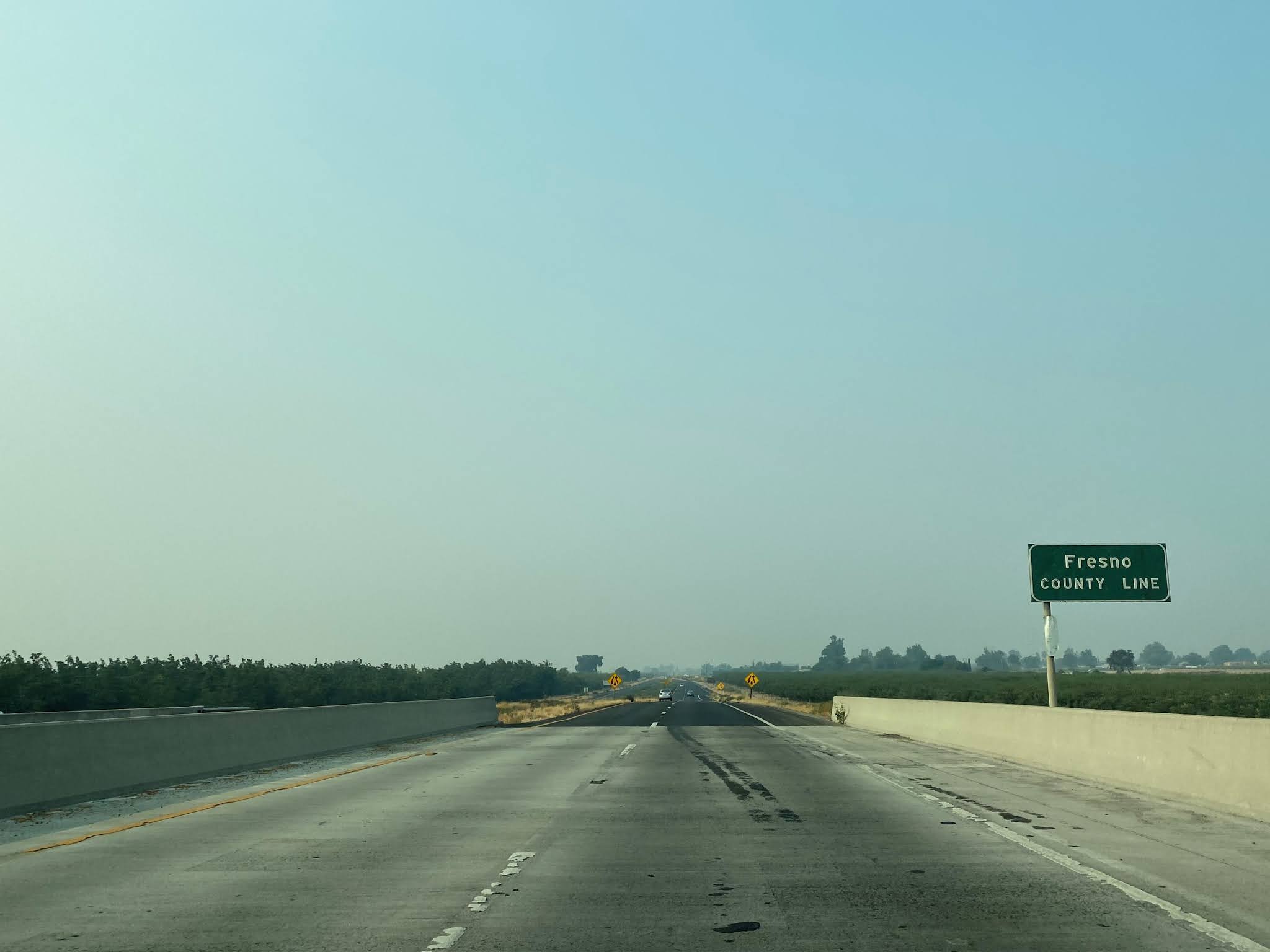
During the weeks prior to the K-Rail installation the center stripe configuration of CA 41 in the Excelsior Avenue-Elkhorn Avenue were widened to accommodate installation.
As CA 41 northbound approaches the Fresno County Line at Excelsior Avenue it drops to two lanes where the first K-Rail barrier can be found.
The first K-Rail on CA 41 northbound gives away approaching Laguna Avenue at Postmile FRE R1.01.
A second K-Rail on CA 41 north of Laguna Avenue begins and gives way at Mountain Whitney Avenue in Camden at Postmile FRE R2.03.
A third K-Rail segment of CA 41 begins north of Mount Whitney Avenue and gives way to another turn lane at Harlan Avenue located at Postmile FRE R3.04.
A fourth and final K-Rail segment of CA 41 begins north of Harlan Avenue. At Postmile R3.5 CA 41 crosses Murphy Slough where the K-Rail installation has rendered the shoulder narrow. The K-Rail installation on CA 41 between Excelsior Avenue and Elkhorn Avenue included a gravel extension of the shoulders.
The fourth K-Rail barrier on CA 41 northbound gives way at Postmile FRE R6.0 at Elkhorn Avenue.
As CA 41 north of Elkhorn Avenue expands back out to four lanes an incomplete stub of the Excelsior Avenue-Elkhorn Avenue two lane segment can be observed on the right.


Comments
https://www.fresnobee.com/news/local/article259462334.html
No timeframe yet for construction to begin, however.