California State Route 1 north from the City of Santa Cruz in Santa Cruz County north to the City of Half Moon Bay of San Mateo County largely lines the Pacific Coast at the western flank of the Santa Cruz Mountains. California State Route 1in the Santa Cruz-Half Moon Bay corridor has numerous older inland alignments which were inherited from 19th Century wagon roads. Pictured above is a photo of Pescadero Beach from the July 1940 California Highways & Public Works displaying right-of-way recently acquired to realign California State Route 1.
Part 1; the history of California State Route 1 in the Santa Cruz-Half Moon Bay corridor
During the early period of the American State of California travel along the shores of Santa Cruz County and San Mateo County was difficult. Prior to the arrival of Europeans a well established Native American overland trail existed over Montara Mountain north of Half Moon Bay. This trail was replaced in 1879 when San Mateo County completed the Half Moon Bay-Colma Road as a stage route. The Half Moon Bay-Colma Road eased access to the community of Half Moon Bay and connected several others (namely; San Gregorio, Pescadero, Swanton and Davenport) via an existing stage road south to Santa Cruz. The general path of the Half Moon Bay-Colma Road over Montara Mountain along with the stage road south to Santa Cruz can be seen on the 1882 Bancroft's Map of California and Nevada.

The coastline between San Francisco south to Santa Cruz ultimately became populated enough that the Ocean Shore Railroad sought to build a line between the two cities. The Ocean Shore Railroad operated from 1905 to 1920 but ultimately was never completed between Tunitas Creek and Swanton.
San Mateo County seeing a need for a better road over Montara Mountain completed what was then known as "Coastside Highway" (now Old Pedro Mountain Road) by 1915 as a replacement for the Half Moon Bay-Colma Road. Coastside Highway traversed Montara Mountain via the 922 foot high Saddle Pass. Coastline Highway carried a far more gentle 5% average grade which made it far easier for the average car to traverse compared to the Half Moon Bay-Colma Road. The opening of Coastside Highway brought even further ease of access of to the communities between Half Moon Bay and Santa Cruz
Old Pedro Mountain Road is a significant enough section of highway that a dedicated Gribblenation blog can be found below:
During 1933
Legislative Route Number 56 ("LRN 56") was extended north from Cambria towards Fernbridge and US Route 101. This new definition of LRN 56 carried numerous segments of coastal highway including the existing roadway from Santa Cruz north Half Moon Bay along with Old Pedro Mountain Road. In the
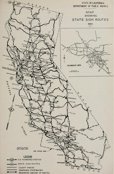
August 1934 California Highways and Public Works Guide the Sign State Routes were announced. CA 1 was applied to LRN 56 from Las Cruces northward towards Fernbridge which included Santa Cruz to Half Moon Bay.
Notable original alignments of CA 1 can be be observed on the 1935 Division of Highways Map of Santa Cruz County:
- Scaroni Road over Majors Creek (formerly Laguna Creek) south of Davenport.
- Old Coast Road in Davenport.
- Cement Plant Road and Davenport's Landing Road north Davenport.
- Swanton Road largely following the course of Scott Creek towards Arroyo Las Trancas.
- Pigeon Point Road past the Pigeon Point Lighthouse.
- Bean Hollow Road and Pescadero Creek Road to Pescadero.
- Stage Road from Pescadero north through San Gregorio.
- Verde Road and Purisima Creek Road over Purisima Creek.
- Main Street through Half Moon Bay.
Much of the upcoming realignment of CA 1 around Pescadero and San Gregorio along the Pacific Coast appears as a budgeted project in the
August 1939 California Highways & Public Works.
The
October 1939 California Highways & Public Works discusses the opening of the new alignment of CA 1 from Davenport north to Waddell Creek near the San Mateo County Line. The new alignment of CA 1 is stated to have eliminated 133 curves and had an opening ceremony held on September 15th, 1939. The new alignment of CA 1 replaced Old Coast Road, Cement Plant Road, Davenport's Landing Road and Swanton Road. In the process of being realigned CA 1 bypassed the community of Swanton.
The realignment of CA 1 north of Davenport to the San Mateo County Line appears on the
1940 Division of Highways Map. The planned continuation realignment CA 1 around Pescadero and San Gregorio appears as a planned highway alignment.
The
September 1941 California Highways & Public Works announced the opening of the new alignment of CA 1 on a bypass of Pescadero and San Gregorio. The new alignment of CA 1 is stated to begin at Lake Lucerne and eliminated 214 curves northward bypassing San Gregorio. A dedication ceremony of the new alignment of CA 1 around Pescadero and San Gregorio was held on August 17th, 1941. The new bypass Pescadero and San Gregorio eliminated; Bean Hollow Road, Pescadero Creek Road and Stage Road from the State Highway System.
The new CA 1 bypass of Pescadero and San Gregorio appear on the
1942 Division of Highways Map.

CA 1 north from the San Cruz County Line to Bean Hollow Road appears paved for the first time on the
1954 Division of Highways Map.
The
July/August 1954 California Highways & Public Works announced the CA 1 Half Moon Bay Bypass had been released to contract. The Half Moon Bay Bypass was cited as being necessary provide a continuous high quality highway from San Francisco to Lake Lucerne and would serve as a replacement for Main Street. The remaining 10 miles of CA 1 south past Pigeon Point Lighthouse to the Santa Cruz County Line are stated to be in the preparation stages to realignment. A small segment of CA 1 in Santa Cruz County at Laguna Creek (now Majors Creek) is stated to have been brought up to modernized standards and replaced Scaroni Road.

Part 2; a drive on former California State Route 1 on Swanton Road and the Swanton ghost town site
From modern CA 1 northbound it's original alignment on Swanton Road can be found at Postmile SCR 30.45.
Swanton Road northbound splits inland from CA 1 and crosses a metal road surface bridge over Molino Creek.
Swanton Road continues northbound to the Big Creek Bridge which serves as the boundary to the Swanton town site. The present Big Creek Bridge shows a date stamp of 1940 and a Works Progress Administration stamping.


Swanton was originally settled between Big Creek and Little Creek in the 1870s as stage stop known as Ingall's Station. In the late 19th Century the Laurel Grove Hotel was built at Ingall's Station as travel down the coast to Santa Cruz became more popular. The community name changed to Swanton in 1897 when it first received Post Office Service. Swanton later became the terminus station on the southern leg of the Ocean Shore Railroad. As noted in Part 1 the Ocean Shore Railroad was never completed from Swanton to Tunitas Creek which ensured it stayed popular as a stage stop. Swanton gradually declined and disappeared following the realignment of CA 1 off of Swanton Road.
Swanton Road northbound continues over the Little Creek Bridge.
Swanton Road northbound crosses over Scott Creek and begins to ascend back towards the coast.
Swanton Road northbound climbs via switchbacks over a ridgeline back to modern CA 1 near the San Mateo County Line.
Part 3; former California State Route 1 on Pigeon Point Road and the Pigeon Point Lighthouse
At Postmile SM 7.97 modern CA 1 bisects it's original alignment of Pigeon Point Road which can be used to access the Pigeon Point Light Station State Historical Park. The Pigeon Point Lighthouse at 115 feet tall is claimed to be the tallest lighthouse on the west coast of the United States. The Pigeon Point Lighthouse was constructed during 1871, first lit during 1872 and ultimately automated by 1974.
Part 4; former California State Route 1 through Pescadero and San Gregorio
Modern CA 1 northbound intersects it's original alignment at Postmile SM 10.72 at Bean Hollow Road.
Bean Hollow Road northbound splits from modern CA 1 and crosses the Lake Lucerne Reservoir spillway.
Bean Hollow Road northbound climbs from Lake Lucerne to a ridge above Pescadero Valley.
Bean Hollow Road northbound descends towards Butano Creek in Pescadero Valley. The original alignment of CA 1 northbound would have turned right onto Pescadero Creek Road.
Pescadero Creek Road crosses Butano Road and jogs eastward to the community of Pescadero. The original alignment of CA 1 northbound would have made a left hand turn onto Stage Road. San Gregorio is signed as 7 miles northward from Pescadero.
Pescadero lies on lands which were part lands which became Mexican Rancho Pescadero in 1833. In 1853 during the American period Alexander Moore settled and built a home at the future site of Pescadero. The soil quality of Pescadero Valley along with easy access to lumber prospects attracted numerous settlers during the 1860s. The small community of Pescadero soon emerged and began to thrive upon the stage travel along the coast from San Francisco south to Santa Cruz. The view below depicts downtown Pescadero facing northward on Stage Road.
Stage Road departs Pescadero northward upon crossing Pescadero Creek.
Stage Road north of Pescadero climbs onto a ridgeline facing towards Pompino Creek.
Stage Road northbound descends briefly to Pomponio Creek before climbing another ridge towards San Gregorio Creek. Upon crossing San Gregorio Creek the path of Stage Road intersects CA 84/La Honda Road in San Gregorio.
San Gregorio was established during the 1850s on lands that were once part of Rancho San Gregoria. The
San Gregorio House was constructed in 1850 and can be found at the southwest corner of Stage Road and La Honda Road. The San Gregorio House served as a stage stop for travelers along the coast of San Mateo County. The San Gregorio House was added to the National Register of Historic Places in 1977.


The San Gregorio General Store has been in continuous operation since 1889 and can be found at the northwest intersection of Stage Road and La Hond Road.
Stage Road north of San Gregorio climbs a ridge and ends at modern CA 1.
Part 5; former California State Route 1 on Main Street in Half Moon Bay
Modern CA 1 northbound intersects it's original alignment at Main Street in Half Moon Bay at Postmile SM 27.74. A construction detour required I use Seymour Drive to reach former CA 1 on Main Street.


Former CA 1 on Main Street through Half Moon Bay traverses the downtown corridor of the City and crosses Pilarcitos Creek. Half Moon Bay is considered to be San Mateo County's first real town which began to develop following Rancho Miramontes being granted to Candelario Miramontes in 1841. During the 1840s a small town known as San Benito began to develop on Rancho Miramontes which later came to be known as Spanishtown. The main stage route during the early American period of California followed a path close to the current corridor of CA 92 over the Santa Cruz Mountains to Spanishtown. Spanishtown would officially change it's name to Half Moon Bay in 1874 and would see an even larger influx of travelers upon the opening of the Half Moon Bay-Colma Road in 1879. Half Moon Bay would later incorporate as a City on July 15th, 1959.
Former CA 1 northbound on Main Street intersects CA 92 departing downtown Half Moon Bay.
Main Street north of CA 92 terminates at modern CA 1.


Comments