
Travel New England: Shelburne Falls

The picturesque Village of Shelburne Falls, Massachusetts is a small slice of New England.  The village sits along both sides of the Deerfield River within the Towns of Shelburne and Buckland.  It is home to numerous shops, art galleries, cafes, breweries and more.  


Shelburne Falls is a village of about 1700 residents which is nearly half of the combined population of Shelburne and Buckland.  The area was settled in the mid-1700s with both Shelburne and Buckland incorporated by 1779.


Two of the major attractions in Shelburne Falls is the Bridge of Flowers and the Glacial Potholes. The Bridge of Flowers is a concrete arch bridge that originally served as a trolley bridge over the Deerfield River. Opened in 1909, the bridge carried freight and passengers for the Shelburne Falls & Colrain Street Railway for nearly 20 years until the railway company went bankrupt.  It was in 1928, when members of the local Women's Club, petitioned and raised funds to convert the old trolley bridge to an open air garden.


The bridge is always full of tourists and photographers - professional and amateur alike.  The blooms are amazing in any season and is one of my all time favorite photography spots.


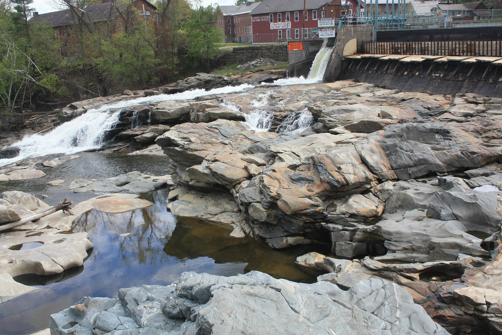
The glacial potholes along the Deerfield River date to the end of the last Ice Age over 14,000 years ago.  As the glaciers receded, the Deerfield River began to erode at the sediment and bedrock below.  The process is a result of strong whirlpools within the currents of the Deerfield River.  The potholes sit below Salmon Falls named after the once numerous salmon that would leap the falls to return to their spawning pools.


Shelburne Falls is a great stop for those traveling through Massachusetts along the Mohawk Trail or even Interstate 91.  The small village really does have something for everyone.

All photos taken by post author - October 2006 & May 2012.

Further Reading:

Comments

Popular posts from this blog

Paper Highways: The Unbuilt New Orleans Bypass (Proposed I-410)

  There are many examples around the United States of proposed freeway corridors in urban areas that never saw the light of day for one reason or another. They all fall somewhere in between the little-known and the infamous and from the mundane to the spectacular. One of the more obscure and interesting examples of such a project is the short-lived idea to construct a southern beltway for the New Orleans metropolitan area in the 1960s and 70s. Greater New Orleans and its surrounding area grew rapidly in the years after World War II, as suburban sprawl encroached on the historically rural downriver parishes around the city. In response to the development of the region’s Westbank and the emergence of communities in St. Charles and St. John the Baptist Parishes as viable suburban communities during this period, regional planners began to consider concepts for new infrastructure projects to serve this growing population.  The idea for a circular freeway around the southern perimeter of t

Hernando de Soto Bridge (Memphis, TN)

The newest of the bridges that span the lower Mississippi River at Memphis, the Hernando de Soto Bridge was completed in 1973 and carries Interstate 40 between downtown Memphis and West Memphis, AR. The bridge’s signature M-shaped superstructure makes it an instantly recognizable landmark in the city and one of the most visually unique bridges on the Mississippi River. As early as 1953, Memphis city planners recommended the construction of a second highway bridge across the Mississippi River to connect the city with West Memphis, AR. The Memphis & Arkansas Bridge had been completed only four years earlier a couple miles downriver from downtown, however it was expected that long-term growth in the metro area would warrant the construction of an additional bridge, the fourth crossing of the Mississippi River to be built at Memphis, in the not-too-distant future. Unlike the previous three Mississippi River bridges to be built the city, the location chosen for this bridge was about two

Huey P. Long Bridge (New Orleans, LA)

Located on the lower Mississippi River a few miles west of New Orleans, the Huey P. Long Bridge is an enormous steel truss bridge that carries both road and rail traffic on an old-time structure that is a fascinating example of a bridge that has evolved in recent years to meet the traffic and safety demands of modern times. While officially located in suburban Jefferson Parish near the unincorporated community of Bridge City, this bridge’s location is most often associated with New Orleans, given that it’s the largest and most recognizable incorporated population center in the nearby vicinity. For this reason, this blog article considers the bridge’s location to be in New Orleans, even though this isn’t 100% geographically correct. Completed in 1935 as the first bridge across the Mississippi River in Louisiana and the first to be built in the New Orleans area, this bridge is one of two bridges on the Mississippi named for Huey P. Long, a Louisiana politician who served as the 40th Gove