Over the past three years on my travels to Monterey I've passed through the Castroville dozens of times. Given my visits to Castroville have been frequent I have been able to locate the historic alignments of the State Highways through he community.

Castroville is located at near Monterey Bay and the mouth of Salinas River in western Monterey County. Castroville is presently served by; CA 1/Cabrillo Highway, CA 183/Merritt Street and the CA 156 freeway.

Castroville was founded in 1863 off of land that was part of Rancho Bolsa Nueva y Moro Cojo. Castroville would gain importance when it became a siding of the Southern Pacific Railroad during the 1870s. While the community of Castroville was largely always centered around agriculture it has come to be known as the Artichoke Center of the World. Artichokes have been planted in Castroville since 1922 which has come to be what the community is most known for. Between 1959 to 2009 Castroville was host to the Castroville Artichoke Festival (which has moved to the Monterey County Fairgounds). The "Castroville Artichoke Capital of World" sign is located on CA 183/Merritt Street at the corner of Preston Road.

State Highway service in Castroville came in 1933 when several Legislative Routes were added in the community:
- Legislative Route 56 was extended from Carmel through Castroville to an ultimate north terminus in Ferndale.
- Legislative Route 22 was extended west of LRN 2 to a terminus in Castroville.
- Legislative Route 118 which was a brand new State Highway between Castroville and Salinas.
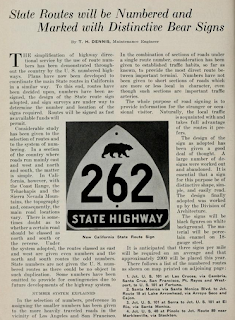
In an August 1934 Department of Public Works Publication CA 1 was announced as the Sign State Route following LRN 56 through Castroville.
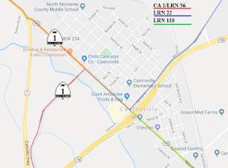
Originally CA 1/LRN 56 northbound entered Castroville via Preston Road where it turned left at Merritt Street. LRN 22 westbound entered Castroville by way of an at-grade crossing of the Southern Pacific Railroad from Castroville Boulevard onto Salinas Street. LRN 22 made a right had turn on Merritt Street and met CA 1/LRN 56 at Preston Road. LRN 118 northbound entered Castroville on Merritt Street and terminated at LRN 22 at Salinas Street. The below graphic depicts the original State Highway alignments through Castroville.
Former CA 1 on Preston Road juts west of Merritt Street and crosses Tembladera Slough on a bridge with an unknown build date. Former CA 1 on Preston Road continues west to the present split in the CA 1/CA 156 freeways.


CA 156 first appears as a Signed State Highway on the 1938 Division of Highways Map of California. Oddly no Department of Public Work Publications aside from State Maps appear to reference CA 156 at all even through the 1940s. It isn't readily apparent if CA 156 was simply aligned from CA 152 west to US 101 or all the way west to CA 1 in Castroville.

The original alignment of LRN 22 in Castroville can be seen on modern Castroville Boulevard headed westbound towards CA 156. As Castroville Boulevard swings left towards modern CA 156 the abandoned highway can be seen ahead approaching the Union Pacific Railroad tracks. CA 156 would have originally crossed the tracks at an at-grade crossing onto Salinas Street in Castroville. A pedestrian overpass now exists where the at-grade highway crossing once existed.

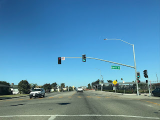
Below is the current eastern end of Salinas Street looking towards the Union Pacific Railroad tracks. LRN 22 and CA 156 would have crossed over the railroad tracks where the pedestrian overpass presently is located.

As noted above CA 156 and LRN 22 would have originally headed westbound on Salinas Street to Merritt Street. Originally LRN 22 and possibly CA 156 turned northward towards downtown Castroville and CA 1 before 1944. After 1944 CA 156 (the highway shows up topographical maps from an undetermined date) terminated at Merritt Street where it meet CA 1 which would have come in from the opposite direction on Salinas Street. Southbound Merritt Street was LRN 118 which became CA 183 during the 1964 Highway Renumbering.


The original alignment of LRN 22 continued northward on Merritt Street where it would have terminated at CA 1 which was on Preston Road. The intersection of Merritt Street and Preston Road is easily identified by the "Castroville; The Artichoke Center Of The World" sign.


CA 156 between Prunedale west to Castroville was realigned onto the modern two-lane expressway circa 1944. The new route of CA 156 from Prunedale to Castroville is discussed in the September/October 1944 California Highway and Public Works guide. The realignment of CA 156 between Castroville and Prunedale was built in conjunction with a realignment of CA 1 through Castroville. CA 156 subsequently met CA 1 at western terminus along Salinas Street at Merritt Street. There was no documented change to LRN 118.


The below map illustrates how the State Highways in Castroville looked in 1944.

As noted above in the September/October 1944 California Highway and Public Works guide part of the realignment of CA 1/LRN 56 included a new crossing of the Salinas River to the south Castroville. Originally CA 1 crossed the 1914 Neponset Truss Bridge next to the Southern Pacific Monterey Branch. The 1943 Salinas River Bridge is described as a 785 foot long continuous girder type with a 26 foot wide road deck. Interestingly the temporary bridge structure didn't survive the winter of 1943 and it forced military traffic onto a temporarily planked 1903 Southern Pacific Truss Bridge. The map below illustrates the difference in the original alignment of CA 1/LRN 56 compared to it's improved 1944 route.

The 1943 Salinas River Bridge is still used as part of Monte Road next to the CA 1 Freeway. The 1903 Southern Pacific Bridge is also present and hasn't seen use since the 1990s.

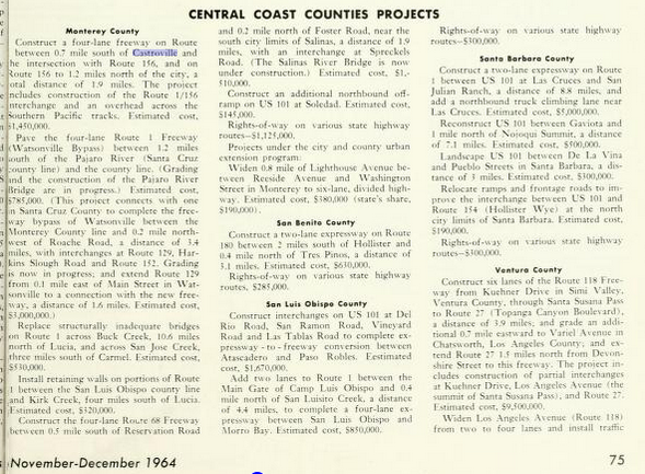
During the 1964 State Highway Renumbering all Legislative Routes were dropped in favor of field signage. CA 1 and CA 156 essentially remained the same but LRN 118 was reassigned as CA 183. On November/December 1964 California Highways and Public Works guide a new freeway alignment of CA 1 in Castroville is discussed which included a new junction with CA 156. This new alignment included CA 156 being routed over a new overpass of the Southern Pacific Railroad in Castroville.

On the 1967 Division of Highways State Map the new route of CA 1 and CA 156 in Castroville appear as completed. Note; CA 156 is shown having a planned freeway route east to Prunedale which was never built.

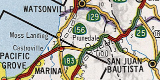
The map below illustrates what the highways in Castroville looked like upon the completion of the freeway junction of CA 1/CA 156. Note; CA 1 is shown in red, CA 156 in blue and CA 183 in green just as LRN 118 was above.

At some point between 1979 and 1981 CA 1 was relocated west of Castroville onto a bypass (the bridge ID of CA 156 west under CA 1 north is blacked out in field). The realignment of CA 1 extended CA 156 west onto the Castroville Freeway grade to it's present west terminus and shifted CA 183 through downtown via Merritt Street. The new alignment of CA 1 and CA 156 can be seen on the 1981 Caltrans State Highway Map.
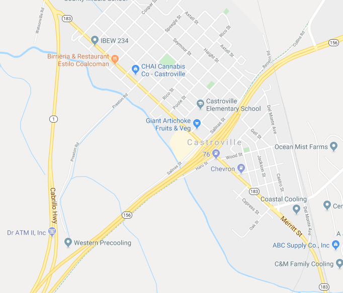
The below map is the current Google Image of the alignments of CA 1, CA 156 and CA 183 through Castroville.
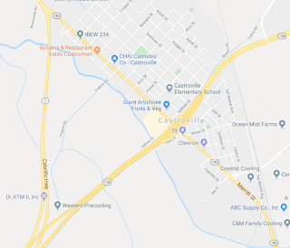
Beginning with modern CA 1 northbound it splits away from CA 156 eastbound via the Castroville Bypass.


CA 1 northbound meets CA 183 at the north end of Merritt Street on the Castroville Bypass.

From CA 1 northbound approaching CA 156 eastbound in Castroville the flow of the freeway clearly shows that it was once part of the former route. Interestingly as modern CA 156 east passes by CA 183 towards Castroville Boulevard a ghost expressway stub can be seen as the highway becomes two-lanes.


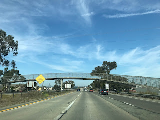


In recent years CA 156 has become one of the busiest two-lane highways in all of California from CA 183 east to US 101. There is a recent talk about using SB1 funds to construct a full expressway grade on CA 156 between CA 183 east to US 101, discussion can be found in this article.
The modern alignment of CA 183 southbound through Castroville is aligned on Merritt Street from CA 1 beyond CA 156 towards Salinas. CA 183 becomes Castroville Road upon crossing the Union Pacific Monterey Branch rails south of CA 156.


Castroville is located at near Monterey Bay and the mouth of Salinas River in western Monterey County. Castroville is presently served by; CA 1/Cabrillo Highway, CA 183/Merritt Street and the CA 156 freeway.

Castroville was founded in 1863 off of land that was part of Rancho Bolsa Nueva y Moro Cojo. Castroville would gain importance when it became a siding of the Southern Pacific Railroad during the 1870s. While the community of Castroville was largely always centered around agriculture it has come to be known as the Artichoke Center of the World. Artichokes have been planted in Castroville since 1922 which has come to be what the community is most known for. Between 1959 to 2009 Castroville was host to the Castroville Artichoke Festival (which has moved to the Monterey County Fairgounds). The "Castroville Artichoke Capital of World" sign is located on CA 183/Merritt Street at the corner of Preston Road.

State Highway service in Castroville came in 1933 when several Legislative Routes were added in the community:
- Legislative Route 56 was extended from Carmel through Castroville to an ultimate north terminus in Ferndale.
- Legislative Route 22 was extended west of LRN 2 to a terminus in Castroville.
- Legislative Route 118 which was a brand new State Highway between Castroville and Salinas.
In an August 1934 Department of Public Works Publication CA 1 was announced as the Sign State Route following LRN 56 through Castroville.

Originally CA 1/LRN 56 northbound entered Castroville via Preston Road where it turned left at Merritt Street. LRN 22 westbound entered Castroville by way of an at-grade crossing of the Southern Pacific Railroad from Castroville Boulevard onto Salinas Street. LRN 22 made a right had turn on Merritt Street and met CA 1/LRN 56 at Preston Road. LRN 118 northbound entered Castroville on Merritt Street and terminated at LRN 22 at Salinas Street. The below graphic depicts the original State Highway alignments through Castroville.

Former CA 1 on Preston Road juts west of Merritt Street and crosses Tembladera Slough on a bridge with an unknown build date. Former CA 1 on Preston Road continues west to the present split in the CA 1/CA 156 freeways.


CA 156 first appears as a Signed State Highway on the 1938 Division of Highways Map of California. Oddly no Department of Public Work Publications aside from State Maps appear to reference CA 156 at all even through the 1940s. It isn't readily apparent if CA 156 was simply aligned from CA 152 west to US 101 or all the way west to CA 1 in Castroville.

The original alignment of LRN 22 in Castroville can be seen on modern Castroville Boulevard headed westbound towards CA 156. As Castroville Boulevard swings left towards modern CA 156 the abandoned highway can be seen ahead approaching the Union Pacific Railroad tracks. CA 156 would have originally crossed the tracks at an at-grade crossing onto Salinas Street in Castroville. A pedestrian overpass now exists where the at-grade highway crossing once existed.

Below is the current eastern end of Salinas Street looking towards the Union Pacific Railroad tracks. LRN 22 and CA 156 would have crossed over the railroad tracks where the pedestrian overpass presently is located.

As noted above CA 156 and LRN 22 would have originally headed westbound on Salinas Street to Merritt Street. Originally LRN 22 and possibly CA 156 turned northward towards downtown Castroville and CA 1 before 1944. After 1944 CA 156 (the highway shows up topographical maps from an undetermined date) terminated at Merritt Street where it meet CA 1 which would have come in from the opposite direction on Salinas Street. Southbound Merritt Street was LRN 118 which became CA 183 during the 1964 Highway Renumbering.


The original alignment of LRN 22 continued northward on Merritt Street where it would have terminated at CA 1 which was on Preston Road. The intersection of Merritt Street and Preston Road is easily identified by the "Castroville; The Artichoke Center Of The World" sign.


CA 156 between Prunedale west to Castroville was realigned onto the modern two-lane expressway circa 1944. The new route of CA 156 from Prunedale to Castroville is discussed in the September/October 1944 California Highway and Public Works guide. The realignment of CA 156 between Castroville and Prunedale was built in conjunction with a realignment of CA 1 through Castroville. CA 156 subsequently met CA 1 at western terminus along Salinas Street at Merritt Street. There was no documented change to LRN 118.


The below map illustrates how the State Highways in Castroville looked in 1944.

As noted above in the September/October 1944 California Highway and Public Works guide part of the realignment of CA 1/LRN 56 included a new crossing of the Salinas River to the south Castroville. Originally CA 1 crossed the 1914 Neponset Truss Bridge next to the Southern Pacific Monterey Branch. The 1943 Salinas River Bridge is described as a 785 foot long continuous girder type with a 26 foot wide road deck. Interestingly the temporary bridge structure didn't survive the winter of 1943 and it forced military traffic onto a temporarily planked 1903 Southern Pacific Truss Bridge. The map below illustrates the difference in the original alignment of CA 1/LRN 56 compared to it's improved 1944 route.

The 1943 Salinas River Bridge is still used as part of Monte Road next to the CA 1 Freeway. The 1903 Southern Pacific Bridge is also present and hasn't seen use since the 1990s.

During the 1964 State Highway Renumbering all Legislative Routes were dropped in favor of field signage. CA 1 and CA 156 essentially remained the same but LRN 118 was reassigned as CA 183. On November/December 1964 California Highways and Public Works guide a new freeway alignment of CA 1 in Castroville is discussed which included a new junction with CA 156. This new alignment included CA 156 being routed over a new overpass of the Southern Pacific Railroad in Castroville.
On the 1967 Division of Highways State Map the new route of CA 1 and CA 156 in Castroville appear as completed. Note; CA 156 is shown having a planned freeway route east to Prunedale which was never built.
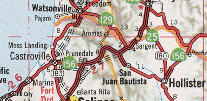
The map below illustrates what the highways in Castroville looked like upon the completion of the freeway junction of CA 1/CA 156. Note; CA 1 is shown in red, CA 156 in blue and CA 183 in green just as LRN 118 was above.

At some point between 1979 and 1981 CA 1 was relocated west of Castroville onto a bypass (the bridge ID of CA 156 west under CA 1 north is blacked out in field). The realignment of CA 1 extended CA 156 west onto the Castroville Freeway grade to it's present west terminus and shifted CA 183 through downtown via Merritt Street. The new alignment of CA 1 and CA 156 can be seen on the 1981 Caltrans State Highway Map.

The below map is the current Google Image of the alignments of CA 1, CA 156 and CA 183 through Castroville.
Beginning with modern CA 1 northbound it splits away from CA 156 eastbound via the Castroville Bypass.


CA 1 northbound meets CA 183 at the north end of Merritt Street on the Castroville Bypass.

From CA 1 northbound approaching CA 156 eastbound in Castroville the flow of the freeway clearly shows that it was once part of the former route. Interestingly as modern CA 156 east passes by CA 183 towards Castroville Boulevard a ghost expressway stub can be seen as the highway becomes two-lanes.


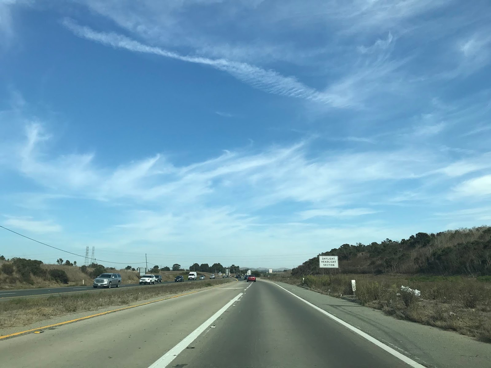


In recent years CA 156 has become one of the busiest two-lane highways in all of California from CA 183 east to US 101. There is a recent talk about using SB1 funds to construct a full expressway grade on CA 156 between CA 183 east to US 101, discussion can be found in this article.
The modern alignment of CA 183 southbound through Castroville is aligned on Merritt Street from CA 1 beyond CA 156 towards Salinas. CA 183 becomes Castroville Road upon crossing the Union Pacific Monterey Branch rails south of CA 156.


Comments