This past October I sought out the original Yosemite National Park entrance alignments of California State Route 140 and California State Route 120.

Presently CA 120 enters Yosemite National Park in Tuolumne County via the modern Big Oak Flat Road. Originally CA 120 entered Yosemite National Park via the Old Tioga Pass Road and CA 140 a entered via the Old Big Oak Flat Road. Previously the history of the Big Oak Flat Road and Tioga Pass Road were discussed on Gribblenation. Articles pertaining to the Big Oak Flat Road and Tioga Pass Road within the boundary of Yosemite National Park can be found below.
History of the Big Oak Flat Road (Yosemite National Park)
The Tioga Pass Road
Part 1; early highways into Yosemite and Legislative Route 40
The Big Oak Flat Road is the second oldest highway into Yosemite just behind the Old Coulterville Road Much of the alignment of CA 120 is presently incorporated by the path set out by the Big Oak Flat Road. The history of the Big Oak Flat Road was discussed in brief on the article above:
"The Big Oak Flat Road began construction east from the mining community of Big Oak Flat in towards Yosemite Valley in 1869. The Big Oak Flat Road was constructed by the Chinese Camp and Yosemite Turnpike Company which had secured the franchise rights for a toll road to the Yosemite Grant (the designation prior to Yosemite National Park). By the summer of 1871 the Big Oak Flat Road reached the northern cliffs above Yosemite Valley which is when the Chinese Camp and Yosemite Turnpike Company ran out of funding. After the Chinese Camp and Yosemite Turnpike Company failed to comment on the the prospective future of the Big Oak Flat Road their franchise rights were turned over to the Coulterville and Yosemite Turnpike Company. The Coulterville and Yosemite Turnpike Company completed the Coulterville Road to Yosemite Valley in June of 1874.
In 1874 the Chinese Camp and Yosemite Turnpike Company went to the California Legislature to petition for reinstatement of their franchise rights to the Big Oak Flat Road. The California Legislature overruled the Yosemite Grant and reinstated the franchise rights of the Chinese Camp and Yosemite Turnpike Comapny to the Big Oak Flat Road. By July of 1874 the Big Oak Flat Road was constructed down to Yosemite Valley. The Big Oak Flat soon overtook Coulterville Road as the popular northern route into Yosemite Valley. The title of the Big Oak Flat Road was turned over to James Hutchings in 1878 who in turn founded the Big Oak Flat and Yosemite Turnpike Road Company in 1879.
In 1914 automobile traffic to Yosemite Valley was authorized by Yosemite National Park which led to the first cars traveling the Big Oak Flat Road. By 1915 Tuolumne County purchased the 30 mile Big Oak Flat Road to remove the tolls. Tuolumne County subsequently turned over the portion of the Big Oak Flat Road east to the Yosemite National Park Boundary to the California Division of Highways. The Division of Highways in turn made the Big Oak Flat Road to the Yosemite National Park boundary an extension of Legislative Route Number 40. The route of the Big Oak Flat Road within Yosemite National Park was turned over by Tuolumne County to the Federal Government."
The history of the early Tioga Pass Road is as follows:
"The Tioga Pass Road is very old with the eastern section up Lee Vining Canyon to the Tioga Mine being built in 1883. The connecting section of the Tioga Pass Road from Big Oak Flat Road was built as a wagon trail from 1902 to 1910. The National Park Service purchased the Tioga Pass Wagon Road in 1915 which was when the era of automotive travel over the road began. Surprisingly Lee Vining Canyon has only a 7% grade which is a significant accomplishment for a roadway in the eastern Sierras."
State Highway maintenance into Yosemite National Park via the Big Oak Flat Road and Tioga Pass Road as mentioned above were part of the spur routes of LRN 40. According to CAhighways the timeline of LRN 40 being adopted into the early State Highway System is as follows:
- In 1899 a new State Highway was defined to connect the basin of Mono Lake westward to the Tioga Road near the Tioga Mine.
- In 1915 new legislation extended LRN 40 over the Tioga Pass Road and Big Oak Flat Road west of the Yosemite National Park boundary.
Early LRN 40 on the Tioga Pass Road and Big Oak Flat Road outside Yosemite National Park can be seen on the 1918 Division of Highways State Map of California.

In an August of 1934 Department of Public Works Guide the Sign State Routes were announced. CA 120 was announced as being signed east of Groveland through Yosemite National Park via the Tioga Pass Road. CA 140 was announced as entering Yosemite National Park via the El Portal Road and connecting to CA 120 through the park by way of the Big Oak Flat Road.

The 1935 Division of Highways Map of Tuolumne County shows in detail State Highway maintenance approaching the boundary of Yosemite National Park. The lower path is the route of CA 140 on the Big Oak Flat Road whereas the top path is CA 120 on the Tioga Pass Road. State maintenance of CA 140 on the Big Oak Flat Road is shown ending at the Crane Flat Ranger Station whereas CA 120 maintenance ends at the Aspen Valley Ranger Station. I marked the paths of CA 120 and CA 140 with shields for graphical clarity.

The below graphic illustrates the original alignments of CA 120/CA 140 on the Big Oak Flat and Tioga Pass Road. Red denotes the path of the Big Oak Flat Road whereas blue denotes the Tioga Pass Road.

Zooming in on the above graphic the original crossing over the South Fork Tuolumne River where CA 120 split from the Big Oak Flat Road onto the Tioga Pass Road can be seen.

In 1940 the current route of the Big Oak Flat Road in Yosemite National Park was opened between Crane Flat and Yosemite Valley. The Old Big Oak Flat Road from Tuolumne Grove to Yosemite Valley was largely converted into a one-way scenic alternate. In 1943 a large rock slide made the Old Big Oak Flat Road inaccessible to cars and a subsequent slide in 1945 took out the 16% grade descending into Yosemite Valley. Given that the newer and much better Big Oak Flat Road was unaffected Yosemite National Park decided to abandoned much of the Big Oak Flat Road.
It wasn't until 1956/1957 that the New Big Oak Flat Road between Evergreen Road and Crane Flat was opened to traffic. After the new alignment of the Big Oak Flat Road between Evergreen Road and Crane Flat opened the Old Big Oak Flat Road from the Carlon Day Use Area to Tuolumne Grove was abandoned or turned into trails. The portion of the Big Oak Flat Road from Crane Flat to the Tuolumne Grove became part of the Tioga Pass Road. This second shift in the alignment of the Big Oak Flat Road can be seen on the 1957 Division of Highways State Map.

The original Tioga Pass Road traversed Aspen Valley Road through Aspen Valley north of the modern Tioga Pass Road where it met up with the current alignment via White Wolf Road. According to the yosemite.ca library article titled "The Tioga Road; a History 1883-1961" the Tioga Pass Road was realigned to the Big Oak Flat Road near Tuolumne Grove east towards White Wolf Road (referred to as McSwain Meadows) in July of 1939. Interestingly it doesn't appear that CA 120 nor CA 140 were immediately changed with the realignment of the Tioga Pass Road. Sometime between 1942 and 1944 CA 140 was cut back to the El Portal Entrance of Yosemite on the Merced River while CA 120 was rerouted off of Evergreen Road onto the Big Oak Flat Road where CA 120 via the current Carlon Day Use Area. The changes are reflected on the 1942 and 1944 Division of Highways State Maps.
1942 Division of Highways State Map

1944 Division of Highways State Map

Part 2; hiking Old California State Route 140 on the Old Big Oak Flat Road into Yosemite
My approach to the older alignments of CA 120 and CA 140 began with a drive on modern CA 120 east in Stanislaus National Forest. The original alignment of CA 120 and the Big Oak Flat Road splits from modern CA 120 at Evergreen Road.


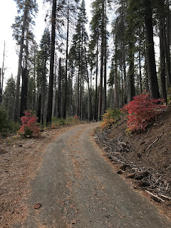
Evergreen Road follows the alignment of Old CA 120/Old Big Oak Flat Road to the South Fork Tuolumne River. There is a modern crossing the South Fork Tuolumne River downstream from the original crossing, I parked at the Carlon Falls Trailhead.


Just behind the Carlon Falls Trailhead the original bridge abutment over the South Fork Tuolumne River can be seen. Ahead in the fourth and fifth photo below the Tioga Pass Road would have had an eastern terminus at the Big Oak Flat Road. CA 120 would have met terminus of CA 140 on the left upon crossing the South Fork South Tuolumne River. Stray asphalt from the early days of the Tioga Pass Road can be seen in the second photo below.


I walked across the South Fork Tuolumne River on the modern Evergreen Road bridge and turned east on the Old Big Oak Flat Road.


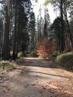
The opposite side of the remains of South Fork Tuolumne River Bridge can be viewed from the original terminus of CA 140 on the Old Big Oak Flat Road.

Old CA 140 on the Big Oak Flat Road is maintained as part of the Carlon Day Use Area to a closure gate at the boundary of Yosemite National Park.


Hikers are advised that the gate on Old CA 140/Old Big Oak Flat Road leads into the Yosemite Wilderness. There is a small gap in the gate which allows hikers to access Yosemite National Park.


Beyond the gate is a clearing where the Carl Inn once stood. The Carl Inn was owned Donna Carlon and was purchased by Federal Government in 1940 so it could be demolished. The Carl Inn was apparently damaged once by flood, twice by snow, and even once by fire before it was razed. Amusingly yosemite.ca has an article from 1956 titled "Self-guided Auto Tour of Yosemite National Park" which not only describes travel on the Big Oak Flat Road before the Carlon Day Use Area-Tuolumne Grove alignment was abandoned but the Carl Inn as well.

I followed Old CA 140/Big Oak Flat Road for approximately two miles south through the Yosemite Wilderness. The asphalt on Old CA 140/Old Big Oak Flat Road is in a fairly good state of repair despite decades of abandonment and probably could be traveled in a car at a careful speed.


Just beyond a Tuolumne County Road maintenance construction marker (how it got back there I have no idea) I turned around to head back towards the Carlon Falls Trailhead.


Part 3; former California State Route 120 to Aspen Valley Road
From the Carlon Falls Trailhead I followed former CA 120/Tioga Pass Road on Evergreen Road to where it splits eastward on Aspen Valley Road.


Old CA 120/Old Tioga Pass Road on Aspen Valley Road continues as Forest Road 01S74 approximately 2 miles east to the Yosemite National Park Boundary. The Forest Service presently lists FR01S74 as a closed road. The Old Tioga Pass Road can be hiked all the way east to the White Wolf Lodge. Given I was in a low clearance vehicle attempting to drive FR01S74 seemed dicey given the grade looked somewhat poor from Aspen Valley Road.


Presently CA 120 enters Yosemite National Park in Tuolumne County via the modern Big Oak Flat Road. Originally CA 120 entered Yosemite National Park via the Old Tioga Pass Road and CA 140 a entered via the Old Big Oak Flat Road. Previously the history of the Big Oak Flat Road and Tioga Pass Road were discussed on Gribblenation. Articles pertaining to the Big Oak Flat Road and Tioga Pass Road within the boundary of Yosemite National Park can be found below.
History of the Big Oak Flat Road (Yosemite National Park)
The Tioga Pass Road
Part 1; early highways into Yosemite and Legislative Route 40
The Big Oak Flat Road is the second oldest highway into Yosemite just behind the Old Coulterville Road Much of the alignment of CA 120 is presently incorporated by the path set out by the Big Oak Flat Road. The history of the Big Oak Flat Road was discussed in brief on the article above:
"The Big Oak Flat Road began construction east from the mining community of Big Oak Flat in towards Yosemite Valley in 1869. The Big Oak Flat Road was constructed by the Chinese Camp and Yosemite Turnpike Company which had secured the franchise rights for a toll road to the Yosemite Grant (the designation prior to Yosemite National Park). By the summer of 1871 the Big Oak Flat Road reached the northern cliffs above Yosemite Valley which is when the Chinese Camp and Yosemite Turnpike Company ran out of funding. After the Chinese Camp and Yosemite Turnpike Company failed to comment on the the prospective future of the Big Oak Flat Road their franchise rights were turned over to the Coulterville and Yosemite Turnpike Company. The Coulterville and Yosemite Turnpike Company completed the Coulterville Road to Yosemite Valley in June of 1874.
In 1874 the Chinese Camp and Yosemite Turnpike Company went to the California Legislature to petition for reinstatement of their franchise rights to the Big Oak Flat Road. The California Legislature overruled the Yosemite Grant and reinstated the franchise rights of the Chinese Camp and Yosemite Turnpike Comapny to the Big Oak Flat Road. By July of 1874 the Big Oak Flat Road was constructed down to Yosemite Valley. The Big Oak Flat soon overtook Coulterville Road as the popular northern route into Yosemite Valley. The title of the Big Oak Flat Road was turned over to James Hutchings in 1878 who in turn founded the Big Oak Flat and Yosemite Turnpike Road Company in 1879.
In 1914 automobile traffic to Yosemite Valley was authorized by Yosemite National Park which led to the first cars traveling the Big Oak Flat Road. By 1915 Tuolumne County purchased the 30 mile Big Oak Flat Road to remove the tolls. Tuolumne County subsequently turned over the portion of the Big Oak Flat Road east to the Yosemite National Park Boundary to the California Division of Highways. The Division of Highways in turn made the Big Oak Flat Road to the Yosemite National Park boundary an extension of Legislative Route Number 40. The route of the Big Oak Flat Road within Yosemite National Park was turned over by Tuolumne County to the Federal Government."
The history of the early Tioga Pass Road is as follows:
"The Tioga Pass Road is very old with the eastern section up Lee Vining Canyon to the Tioga Mine being built in 1883. The connecting section of the Tioga Pass Road from Big Oak Flat Road was built as a wagon trail from 1902 to 1910. The National Park Service purchased the Tioga Pass Wagon Road in 1915 which was when the era of automotive travel over the road began. Surprisingly Lee Vining Canyon has only a 7% grade which is a significant accomplishment for a roadway in the eastern Sierras."
State Highway maintenance into Yosemite National Park via the Big Oak Flat Road and Tioga Pass Road as mentioned above were part of the spur routes of LRN 40. According to CAhighways the timeline of LRN 40 being adopted into the early State Highway System is as follows:
- In 1899 a new State Highway was defined to connect the basin of Mono Lake westward to the Tioga Road near the Tioga Mine.
- In 1915 new legislation extended LRN 40 over the Tioga Pass Road and Big Oak Flat Road west of the Yosemite National Park boundary.
Early LRN 40 on the Tioga Pass Road and Big Oak Flat Road outside Yosemite National Park can be seen on the 1918 Division of Highways State Map of California.
In an August of 1934 Department of Public Works Guide the Sign State Routes were announced. CA 120 was announced as being signed east of Groveland through Yosemite National Park via the Tioga Pass Road. CA 140 was announced as entering Yosemite National Park via the El Portal Road and connecting to CA 120 through the park by way of the Big Oak Flat Road.

The 1935 Division of Highways Map of Tuolumne County shows in detail State Highway maintenance approaching the boundary of Yosemite National Park. The lower path is the route of CA 140 on the Big Oak Flat Road whereas the top path is CA 120 on the Tioga Pass Road. State maintenance of CA 140 on the Big Oak Flat Road is shown ending at the Crane Flat Ranger Station whereas CA 120 maintenance ends at the Aspen Valley Ranger Station. I marked the paths of CA 120 and CA 140 with shields for graphical clarity.

The below graphic illustrates the original alignments of CA 120/CA 140 on the Big Oak Flat and Tioga Pass Road. Red denotes the path of the Big Oak Flat Road whereas blue denotes the Tioga Pass Road.

Zooming in on the above graphic the original crossing over the South Fork Tuolumne River where CA 120 split from the Big Oak Flat Road onto the Tioga Pass Road can be seen.

In 1940 the current route of the Big Oak Flat Road in Yosemite National Park was opened between Crane Flat and Yosemite Valley. The Old Big Oak Flat Road from Tuolumne Grove to Yosemite Valley was largely converted into a one-way scenic alternate. In 1943 a large rock slide made the Old Big Oak Flat Road inaccessible to cars and a subsequent slide in 1945 took out the 16% grade descending into Yosemite Valley. Given that the newer and much better Big Oak Flat Road was unaffected Yosemite National Park decided to abandoned much of the Big Oak Flat Road.
It wasn't until 1956/1957 that the New Big Oak Flat Road between Evergreen Road and Crane Flat was opened to traffic. After the new alignment of the Big Oak Flat Road between Evergreen Road and Crane Flat opened the Old Big Oak Flat Road from the Carlon Day Use Area to Tuolumne Grove was abandoned or turned into trails. The portion of the Big Oak Flat Road from Crane Flat to the Tuolumne Grove became part of the Tioga Pass Road. This second shift in the alignment of the Big Oak Flat Road can be seen on the 1957 Division of Highways State Map.

The original Tioga Pass Road traversed Aspen Valley Road through Aspen Valley north of the modern Tioga Pass Road where it met up with the current alignment via White Wolf Road. According to the yosemite.ca library article titled "The Tioga Road; a History 1883-1961" the Tioga Pass Road was realigned to the Big Oak Flat Road near Tuolumne Grove east towards White Wolf Road (referred to as McSwain Meadows) in July of 1939. Interestingly it doesn't appear that CA 120 nor CA 140 were immediately changed with the realignment of the Tioga Pass Road. Sometime between 1942 and 1944 CA 140 was cut back to the El Portal Entrance of Yosemite on the Merced River while CA 120 was rerouted off of Evergreen Road onto the Big Oak Flat Road where CA 120 via the current Carlon Day Use Area. The changes are reflected on the 1942 and 1944 Division of Highways State Maps.
1942 Division of Highways State Map

1944 Division of Highways State Map

Part 2; hiking Old California State Route 140 on the Old Big Oak Flat Road into Yosemite
My approach to the older alignments of CA 120 and CA 140 began with a drive on modern CA 120 east in Stanislaus National Forest. The original alignment of CA 120 and the Big Oak Flat Road splits from modern CA 120 at Evergreen Road.


Evergreen Road follows the alignment of Old CA 120/Old Big Oak Flat Road to the South Fork Tuolumne River. There is a modern crossing the South Fork Tuolumne River downstream from the original crossing, I parked at the Carlon Falls Trailhead.


Just behind the Carlon Falls Trailhead the original bridge abutment over the South Fork Tuolumne River can be seen. Ahead in the fourth and fifth photo below the Tioga Pass Road would have had an eastern terminus at the Big Oak Flat Road. CA 120 would have met terminus of CA 140 on the left upon crossing the South Fork South Tuolumne River. Stray asphalt from the early days of the Tioga Pass Road can be seen in the second photo below.


I walked across the South Fork Tuolumne River on the modern Evergreen Road bridge and turned east on the Old Big Oak Flat Road.


The opposite side of the remains of South Fork Tuolumne River Bridge can be viewed from the original terminus of CA 140 on the Old Big Oak Flat Road.

Old CA 140 on the Big Oak Flat Road is maintained as part of the Carlon Day Use Area to a closure gate at the boundary of Yosemite National Park.


Hikers are advised that the gate on Old CA 140/Old Big Oak Flat Road leads into the Yosemite Wilderness. There is a small gap in the gate which allows hikers to access Yosemite National Park.


Beyond the gate is a clearing where the Carl Inn once stood. The Carl Inn was owned Donna Carlon and was purchased by Federal Government in 1940 so it could be demolished. The Carl Inn was apparently damaged once by flood, twice by snow, and even once by fire before it was razed. Amusingly yosemite.ca has an article from 1956 titled "Self-guided Auto Tour of Yosemite National Park" which not only describes travel on the Big Oak Flat Road before the Carlon Day Use Area-Tuolumne Grove alignment was abandoned but the Carl Inn as well.

I followed Old CA 140/Big Oak Flat Road for approximately two miles south through the Yosemite Wilderness. The asphalt on Old CA 140/Old Big Oak Flat Road is in a fairly good state of repair despite decades of abandonment and probably could be traveled in a car at a careful speed.


Just beyond a Tuolumne County Road maintenance construction marker (how it got back there I have no idea) I turned around to head back towards the Carlon Falls Trailhead.


Part 3; former California State Route 120 to Aspen Valley Road
From the Carlon Falls Trailhead I followed former CA 120/Tioga Pass Road on Evergreen Road to where it splits eastward on Aspen Valley Road.


Old CA 120/Old Tioga Pass Road on Aspen Valley Road continues as Forest Road 01S74 approximately 2 miles east to the Yosemite National Park Boundary. The Forest Service presently lists FR01S74 as a closed road. The Old Tioga Pass Road can be hiked all the way east to the White Wolf Lodge. Given I was in a low clearance vehicle attempting to drive FR01S74 seemed dicey given the grade looked somewhat poor from Aspen Valley Road.

Comments
The old Big Oak Flat Entrance was located where your photo shows the gate (the clearing prior to that was the site of the Carl Inn, a notable establishment located just outside the park entrance), although vehicles entering the park this way would not see a ranger until reaching Crane Flat about 10 steep and narrow uphill miles farther on. The New Tioga Road section from Crane Flat to near White Wolf opened in 1938. After that time, Tioga Road bound travelers would stay on 120/Old BOF Road from Carlon up to Crane Flat, and then hit the new modern roadway. For a couple of years, BOF Road vehicles would drive on the new highway from Crane to Gin Flats, and then have to go back to the narrow, steep winding Old BOF Road from that point down into the Valley. Prior to 1938, Tioga Road travelers would cross the old bridge you show in your photo and continue up the Old Tioga Road (partially buried by Evergreen Road).
Thanks, I went back and clarified the timeline after reading your note. I added some article links from yosemite.ca which describe the time frame for the Tuolumne Grove-Carl Inn realignment of the Big Oak Flat Road and the more direct routing of the Tioga Pass Road to Tuolumne Grove and Crane Flat.