
US 15/501 Rerouted From Downtown Pittsboro

Pittsboro, like the rest of Chatham County, is growing.  As a result, heavier truck traffic along US 15/501 through Downtown Pittsboro has led local leadership to ask NCDOT to move US 15/501 as the North/South route through downtown.  

Instead, US 15/501 will be routed along NC 87 North and west of Downtown Pittsboro to the US 64 Bypass.  At the Bypass, 15/501 will head briefly east on US 64 to pick up 15/501's regular route North towards Chapel Hill and Durham.

But this is just temporary.  Just east of Downtown Pittsboro, the Chatham Parkway is being completed.  When that road is finished, US 15/501 will move to the new road and serve as an eastern bypass for North/South traffic around Pittsboro.

NC 902 has been truncated slightly to end at NC 87.  There is no change to Business US 64, as that will continue to travel through Downtown Pittsboro along West and East Streets.

NCDOT has now signed the changes around Pittsboro.  Tracy Snead, a friend of the blog, was kind enough to send along some photos.

US 15/501 is now signed (temporarily) on the US 64 Bypass around Pittsboro. (Tracy Snead)


From the US 64 Bypass West offramp at NC 87.  US 15/501 will now follow NC 87 to Sanford Road. NC 87 at Sanford Road is where the reroute of US 15/501 ends/begins. (Tracy Snead)

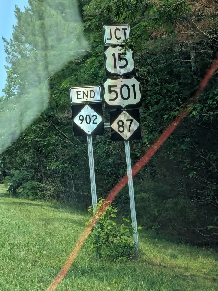
As a result of the US 15/501 route changes, NC 902 now ends at NC 87.  Before this, NC 902 continued North on NC 87 to Business US 64, ending there.  This change eliminates the dual NC 87/902 designation. (Tracy Snead)

Links:

Comments

Popular posts from this blog

2018 Mojave Road Trip Part 2; The deadly desert highway (California State Route 127 and Nevada State Route 373)

After leaving Barstow via Old Highway 58 my next destination was in Death Valley.  To access Death Valley from rural San Bernardino County required a trek on north on Interstate 15 to California State Route 127 which becomes Nevada State Route 373 at the state line. Along I-15 I encountered the road sign oddity that is Zzyzx Road about eight miles south of Baker.   Zzyzx Road is a four mile road that used to go to the Zzyzx Mineral Springs and Health Spa.   The spa was founded in the 1940s and the owner made up the name "Zzyzx" to claim it was the last word in the English Language.  The spa has been shut down since the 1970s and is now part of a Desert Studies Center for California State University. The southern terminus of CA 127 in Baker is located at I-15 exit 246.  CA 127 is a 91 mile north/south highway which runs to the Nevada State Line in Inyo County.  CA 127 is called Death Valley Road from I-15 northward.  South of CA 127 ...

Finding the Pre-Emption Road of New York State

  The Pre-Emption Road (or rather a series of roads named Pre-Emption Road) follows a survey line called the Pre-Emption Line, drawn in the early days of the United States. The story begins with Massachusetts and New York having competing land claims to modern day Western New York State that have their roots in colonial charters granted by the British. After the Revolutionary War ended, this land became the frontier of the nation and its settlement became a priority for the new American government. During this era, there were a lot of competing land claims that needed to be settled. It was no different with the land claims between New York State and Massachusetts. On November 30, 1786, Massachusetts and New York sent representatives to Hartford, Connecticut to resolve their competing land claims. In less than three weeks, the representatives had reached a compromise. Massachusetts would receive pre-emption rights, meaning the right to sell the land after the Indian title ...

What's In a Name?: When the Roads Really Do Tell a Story

  Our tagline on the Gribblenation blog is "because every road tells a story". Some roads tell different stories than others. Along our travels, we may see historic markers that tell us a little story about the roads we travel or the places we pass by. Some historic markers are more general, as to telling us who lived where or what old trail traversed between two towns. During my travels across New York State and other states or provinces, I pass by many historic markers, some with interesting or amusing references to roads. I wanted to highlight a few of the markers I've seen along my travels around the Empire State and help tell their stories. Those stories may be as specific as explaining the tales of a tree that was used to help measure a distance of eight miles from Bath to Avoca in Steuben County, as referenced on the Eight Mile Tree historical marker above. They may also help point the way along historical roads first used centuries ago, or may help tell a local l...