
The BBBBIIIIGGGG Chicken - Marietta, GA


"...turn left at the Big Chicken."

Landmarks, before the era of GPS navigation, physical places, man-made or not, were often used in directions to help get from one place to another.

"...one mile South of the Big Chicken."

On US 41 in Marietta, Georgia - a 56-foot tall red-and-white chicken - complete with a moving beak and rolling eyes - dominates the suburban commercial strip.  You can see it from nearby Interstate 75 - it's simply known as The BIG Chicken.

The story of The Big Chicken dates back to 1963. Stanly "Tubby" Davis wanted a unique way to promote his Johnny Reb's Chick-Chuck-'N'-Shake.  The restaurant served fried chicken, hamburgers, and milkshakes.  It also was a drive-in offering curbside service.

Davis commissioned a local Georgia Tech student, Hubert Puckett, to design the roadside attraction.  Puckett would later be involved in renovations to the structure after it sustained significant storm damage in 1993.

Close-up of the moving beak and rolling eyes of The Big Chicken.

Kentucky Fried Chicken would become the new home of The Big Chicken in 1974.  Puckett sold his business to his brother, who would convert Johnny Reb's to a KFC franchise. 

The seven-story attraction has survived numerous attempts to dismantle it.  At first, Kentucky Fried Chicken did not like the locally beloved landmark.  It would later try to move the bird to another Atlanta location.  However, a January 1993 windstorm would cement The Big Chicken permanently at the corner of Cobb Parkway and Roswell.

The 1993 renovated version of The Big Chicken - (Joe Babyak - January 2008)

High winds had dislodged several steel panels from the body of the chicken.  KFC officials were ready to move on and tear it down. Marietta and area residents protested as it had become a local attraction.  Aircraft pilots also stepped in to support The Big Chicken.  They used The Big Chicken as a landmark on their approaches to nearby airports.  KFC relented - and a renovation project would restore the chicken back to operation the following year.

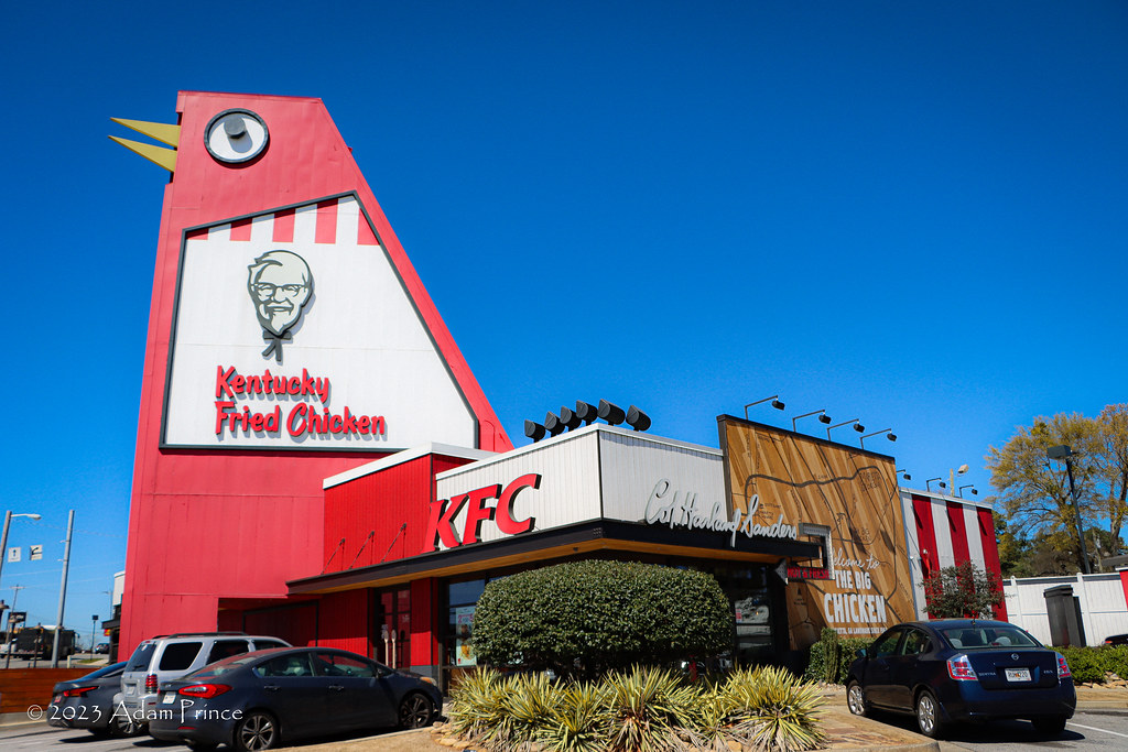
KFC enthusiastically embraced The Big Chicken in the 2017 remodel.

The Big Chicken would undergo a second renovation in 2017.  A $2 million renovation updated the chicken, restaurant, and accompanying gift shop.  The restaurant was updated to modern-KFC standards. And, to show how far KFC-corporate has changed its view of Puckett's chicken, the BIG Chicken is the centerpiece of all the local branding.

All photos taken by post author - March 2023 - unless otherwise noted.

Sources & Links:

How To Get There:

Comments

Popular posts from this blog

2018 Mojave Road Trip Part 2; The deadly desert highway (California State Route 127 and Nevada State Route 373)

After leaving Barstow via Old Highway 58 my next destination was in Death Valley.  To access Death Valley from rural San Bernardino County required a trek on north on Interstate 15 to California State Route 127 which becomes Nevada State Route 373 at the state line. Along I-15 I encountered the road sign oddity that is Zzyzx Road about eight miles south of Baker.   Zzyzx Road is a four mile road that used to go to the Zzyzx Mineral Springs and Health Spa.   The spa was founded in the 1940s and the owner made up the name "Zzyzx" to claim it was the last word in the English Language.  The spa has been shut down since the 1970s and is now part of a Desert Studies Center for California State University. The southern terminus of CA 127 in Baker is located at I-15 exit 246.  CA 127 is a 91 mile north/south highway which runs to the Nevada State Line in Inyo County.  CA 127 is called Death Valley Road from I-15 northward.  South of CA 127 ...

Finding the Pre-Emption Road of New York State

  The Pre-Emption Road (or rather a series of roads named Pre-Emption Road) follows a survey line called the Pre-Emption Line, drawn in the early days of the United States. The story begins with Massachusetts and New York having competing land claims to modern day Western New York State that have their roots in colonial charters granted by the British. After the Revolutionary War ended, this land became the frontier of the nation and its settlement became a priority for the new American government. During this era, there were a lot of competing land claims that needed to be settled. It was no different with the land claims between New York State and Massachusetts. On November 30, 1786, Massachusetts and New York sent representatives to Hartford, Connecticut to resolve their competing land claims. In less than three weeks, the representatives had reached a compromise. Massachusetts would receive pre-emption rights, meaning the right to sell the land after the Indian title ...

What's In a Name?: When the Roads Really Do Tell a Story

  Our tagline on the Gribblenation blog is "because every road tells a story". Some roads tell different stories than others. Along our travels, we may see historic markers that tell us a little story about the roads we travel or the places we pass by. Some historic markers are more general, as to telling us who lived where or what old trail traversed between two towns. During my travels across New York State and other states or provinces, I pass by many historic markers, some with interesting or amusing references to roads. I wanted to highlight a few of the markers I've seen along my travels around the Empire State and help tell their stories. Those stories may be as specific as explaining the tales of a tree that was used to help measure a distance of eight miles from Bath to Avoca in Steuben County, as referenced on the Eight Mile Tree historical marker above. They may also help point the way along historical roads first used centuries ago, or may help tell a local l...