
California State Route 76

California State Route 76 is a 53-mile east/west State Highway completely located within San Diego County.  California State Route 76 begins at Interstate 5 in Oceanside and ends at California State Route 79 near Lake Henshaw.  California State Route 76 between Interstate 5 and Interstate 15 is known as the San Luis Rey Mission Expressway.  Pictured as the blog cover is then Legislative Route Number 195 on Mission Avenue east of Oceanside during February 1939.  Mission Avenue would become part of California State Route 76 when the highway began to be signed during 1951.  Below California State Route 76 can be seen as it was configured on the 2005 Caltrans Map.  


Part 1; the history of California State Route 76

What became California State Route 76 (CA 76) existed prior to becoming part of State Highway System.  A highway following the San Luis Rey River east from Oceanside to Morettis Junction can be seen on the 1917 California State Automobile Association Map.  

In 1925 the concrete arch Bonsall Bridge was constructed over the San Luis Rey River near Bonsall by San Diego County.  The Bonsall Bridge is a 106.0-foot-long span and can be seen in its present pedestrian state in the below photo by Michael Goff from the bridgehunter.com page on the Bonsall Bridge

1933 Legislative Chapter 767 added Legislative Route Number 195 (LRN 195) to the State Highway System.  The initial definition of LRN 195 was "LRN 2/US Route 101 near Oceanside to Descano-Temecula Road near Lake Henshaw."  LRN 195 appears for the first time on the 1934 Division of Highways Map between US Route 101/LRN 2 in Oceanside and LRN 78 at Lake Henshaw.  Speculatively LRN 195 may have been added to provide a State Highway link to the existing highway up Palomar Mountain which was the site of the Palomar Observatory.  Palomar Observatory had been recently established during 1928.


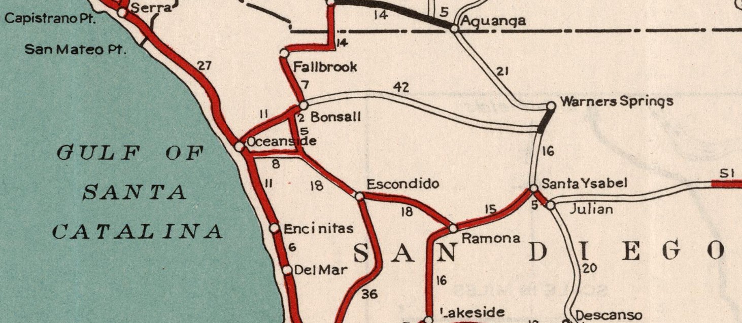
LRN 195 can be seen detail on the 1935 Division of Highways Map of San Diego County.  From US Route 101/LRN 2 in Oceanside LRN 195 can be seen following Mission Avenue and what is now El Camino Real to Mission San Luis Rey de Francia.  From Mission San Luis Rey de Francia LRN 195 is seen following what is now San Luis Rey Avenue, Mission Avenue and grade now under the San Luis Rey Mission Expressway eastward to Bonsall via the 1925 Bonsall Bridge.  From Vista Way east to Bonsall the corridor of LRN 195 was part of LRN 77 and became part of US Route 395 when it was extended to California during 1934.  

From Bonsall LRN 195 followed a grade now under the San Luis Rey Mission Expressway to the future location of Interstate 15.  East of the current site of Interstate 15 the alignment of LRN 195 followed Pala Road to Pala.  

From Pala LRN 195 followed Pala Road eastward to LRN 78 at Morretis Junction near Henshaw Lake.  LRN 195 provided access to both ends of the road looping from Palomar Mountain.  LRN 78 was assigned as part of CA 79 when the Sign State Routes were announced during August 1934.  

The August 1935 California Highways & Public Works announced a contract to pave LRN 195 with asphalt east of Bonsall. 

The April 1936 California Highways & Public Works discusses construction of new highway which would link LRN 195 to Palomar Observatory near Rincon.  The existing highway to Palomar Mountain is described as being a treacherous trail constructed by San Diego County.  The new road from LRN 195 to Palomar Mountain is cited to have a planned length of 11.8 miles.  The new road from LRN 195 to Palomar Mountain is stated to be a San Diego County Feeder Road project which had received Federal Funding.  The new road to Palomar Mountain was partially constructed by San Diego County with the upper portions to be constructed by the Division of Highways.  A sketch depicting what would become the Hale Telescope is depicted.  The new highway to Palomar Observatory is described as being necessary for transportation of the two-hundred-inch mirror of the planned Hale Telescope.


The January 1937 California Highways & Public Works features ongoing construction on the new connecting road from LRN 195 near Rincon to Palomar Observatory.  5.3 miles of highway from LRN 195 to Cu Cu Mesa are cited to be already open with 2.8 miles presently under construction by the Division of Highways via the so-called Cu Cu Grade.  The road from Cu Cu Mesa is stated to climb to Palomar Observatory atop the 5,568-foot-high Mount Palomar.  The new road between LRN 195 and Palomar Observatory is stated to have a planned completion during the coming May.  


The April 1938 California Highways & Public Works noted segments of LRN 195 between Bonsall and Morettis having been damaged by heavy rainstorms during the previous February-March 1938.  The Cuca Grade is cited as having been particularly subject to slides.  


A blind curve on LRN 195 east of Oceanside is featured in the February 1939 California Highways & Public Works.  


The September 1939 California Highways & Public Works features the Highway to the Stars connecting LRN 195 five miles east to Rincon to Palomar Observatory.  


The history of Mission San Luis Rey de Francia is on LRN 195 between Oceanside and Bonsall is featured in the November/December 1944 California Highways & Public Works.  Mission San Luis Rey de Francia had been established on June 13th, 1789, as one of what would ultimately be one of twenty-one Spanish Catholic Missions spanning San Diego from north to Sonoma via El Camino Real.  Construction of the church at Mission San Luis Rey de Francia began during 1810 and was completed on October 4th, 1815. 


The modernization of US Route 395/LRN 77 between San Diego and Riverside appears in an article in the November/December 1946 California Highways & Public Works.  The new alignment of US Route 395/LRN 77 once complete would provide a direct north/south routing between San Diego and Riverside by way of Escondido.  The new alignment of US Route 395/LRN 77 once complete would remove it from LRN 195 in the vicinity of Bosnall.  


The planned new alignment of US Route 395/LRN 77 between San Diego and Riverside appears on the 1948 Division of Highways Map.  


The November/December 1950 California Highways & Public Works featured the opening of the new 18.3-mile alignment of US Route 395/LRN 77.  The new alignment of US Route 395/LRN 77 was routed directly north from Miramar towards Temecula via Escondido.  The new alignment of US Route 395 left LRN 195 as a standalone routing through Bonsall.


The 1951 Division of Highways Map displays the new alignment of US Route 395/LRN 77 through Escondido

The May/June 1951 California Highways & Public Works features junction signage directing traffic on US Route 395/LRN 77 at LRN 195 to Oceanside.  The sign directing traffic onto LRN 195 to reach Oceanside is stated to have been requested by the Oceanside Chamber of Commerce.  

The 1952 Division Highways Map is the first to feature LRN 195 signed as CA 76.  CA 76 seems to have been applied to LRN 195 as part of the signage requested by Oceanside Chamber of Commerce.  Notably the Hale Telescope at Palomar Observatory saw first light on January 26th, 1949 and may have provided additional rationale to add a Sign State Route to LRN 195.   


CA 76/LRN 195 (shown mistakenly as CA 67) is seen terminating at US Route 101 Business at Hill Street via Mission Avenue on a map displayed in the May/June 1954 California Highways & Public Works.  


The January/February 1956 California Highways & Public Works announced a contract to widen CA 76/LRN 195 in Oceanside between Santa Barbara Street and Mesa Drive to a four-lane divided highway.


CA 76/LRN 195 between US Route 101/Interstate 5/LRN 2 in Oceanside east to US Route 395/Interstate 15/LRN 77 was added to the Freeways & Expressways System in 1959.  The connecting road from CA 76/LRN 195 to Palomar Observatory was designated as part of County Sign Route S6 during 1959.  According cahighways.org the California Highway Commission adopted a freeway routing of CA 76/LRN 195 between planned Interstate 5 and Interstate 15 on January 23rd, 1963.  

As part of the 1964 State Highway Renumbering the Legislative Route Numbers were dropped.  Subsequently CA 76 inherited the full definition of LRN 195 which first appears on the 1964 Division of Highways Map.  


The Division of Highways reached agreements with San Diego County on June 25th, 1964 and the city of Oceanside on April 1st, 1965 to convert CA 76 into a freeway.  The California Highways & Public Works publication ended in 1967 prior to the expressway expansion of CA 76 between Interstate 5 and Interstate 15.  Much of the post-1967 information regarding the expansion of CA 76 between Interstate 5 and Interstate 15 comes from the Wikipedia reference log in the article below:


The expansion of CA 76 between Interstate 5 and Interstate 15 faced numerous years of delays, especially as Mission Avenue functionally became obsolete as State Highway.  During 1983 the Federal Gas taxed provided a vehicle through which replacement of the Bonsall Bridge could be pursued.  During May 1983 Caltrans approved the 2.5 western most miles of CA 76 to be realigned in Oceanside.  The realignment of CA 76 was delayed for several years due to environmental concerns, but the project was finally approved by the U.S Fish & Wildlife Service during November 1987. 

The California Transportation Commission approved a project to replace the Bonsall Bridge during October 1988.  The replacement of the Bonsall Bridge broke ground during early 1989 and was opened to traffic during 1990.  Following completion of the new bridges over the San Luis Rey River the Bonsall Bridge was converted to a historic pedestrian trail.  The Bonsall Bridge has since been added to the National Register of Historic Places.  

The expansion/realignment of CA 76 in Oceanside faced several more years of environmental challenges before breaking ground in 1994 as an expressway rather than a freeway.  The new CA 76 expressway in Oceanside between Interstate 5 and Foussat Road opened to traffic during late year 1995.  CA 76 between Interstate 5 and Interstate 15 was named the San Luis Mission Expressway by way of Assembly Concurrent Resolution Number 6, Chapter 54 during 1995.  During June 1996 the second phase of the expressway expansion of CA 76 between Interstate 5 and Interstate 15 began.  During 1996 the estimated timeframe for CA 76 to be fully expanded to four-lane expressway between Interstate 5 and Interstate 15 was targeted for completion by 2010.  The California Transportation Commission rescinded the freeway designation of CA 76 east of Riverside to Interstate 15 during March 2016.  Ultimately CA 76 would be fully expanded to four-lane expressway standards between Interstate 5 and Interstate 15 by May 2017. 

Below CA 76 can be seen on the 2005 Caltrans Map built to expressway standards between Interstate 5 and the vicinity of Bonsall.  

Comments

Popular posts from this blog

Paper Highways: The Unbuilt New Orleans Bypass (Proposed I-410)

  There are many examples around the United States of proposed freeway corridors in urban areas that never saw the light of day for one reason or another. They all fall somewhere in between the little-known and the infamous and from the mundane to the spectacular. One of the more obscure and interesting examples of such a project is the short-lived idea to construct a southern beltway for the New Orleans metropolitan area in the 1960s and 70s. Greater New Orleans and its surrounding area grew rapidly in the years after World War II, as suburban sprawl encroached on the historically rural downriver parishes around the city. In response to the development of the region’s Westbank and the emergence of communities in St. Charles and St. John the Baptist Parishes as viable suburban communities during this period, regional planners began to consider concepts for new infrastructure projects to serve this growing population.  The idea for a circular freeway around the southern perimeter of t

Hernando de Soto Bridge (Memphis, TN)

The newest of the bridges that span the lower Mississippi River at Memphis, the Hernando de Soto Bridge was completed in 1973 and carries Interstate 40 between downtown Memphis and West Memphis, AR. The bridge’s signature M-shaped superstructure makes it an instantly recognizable landmark in the city and one of the most visually unique bridges on the Mississippi River. As early as 1953, Memphis city planners recommended the construction of a second highway bridge across the Mississippi River to connect the city with West Memphis, AR. The Memphis & Arkansas Bridge had been completed only four years earlier a couple miles downriver from downtown, however it was expected that long-term growth in the metro area would warrant the construction of an additional bridge, the fourth crossing of the Mississippi River to be built at Memphis, in the not-too-distant future. Unlike the previous three Mississippi River bridges to be built the city, the location chosen for this bridge was about two

Huey P. Long Bridge (New Orleans, LA)

Located on the lower Mississippi River a few miles west of New Orleans, the Huey P. Long Bridge is an enormous steel truss bridge that carries both road and rail traffic on an old-time structure that is a fascinating example of a bridge that has evolved in recent years to meet the traffic and safety demands of modern times. While officially located in suburban Jefferson Parish near the unincorporated community of Bridge City, this bridge’s location is most often associated with New Orleans, given that it’s the largest and most recognizable incorporated population center in the nearby vicinity. For this reason, this blog article considers the bridge’s location to be in New Orleans, even though this isn’t 100% geographically correct. Completed in 1935 as the first bridge across the Mississippi River in Louisiana and the first to be built in the New Orleans area, this bridge is one of two bridges on the Mississippi named for Huey P. Long, a Louisiana politician who served as the 40th Gove