In the August 1934 California Highways & Public Works the Division of Highways announced the initial Sign State Route program. The Sign State Route program was intended to supplement the early US Route System in California by way of signing major highways with miner spade shaped highway shields. The original Sign State Route network contained numerous grouping patterns which largely have been lost as the system has expanded. This blog will examine the grouping patterns of the Sign State Route program as originally envisioned. Featured as the blog cover photo is the prototype Sign State Route shield seen in the August 1934 California Highways & Public Works.
Conventions of the original Sign State Route grid and grouping patterns
As noted in the introduction the August 1934 California Highways & Public Works announced the initial run of Sign State Routes. The initial Sign State Routes were assigned to corridors of travel that were largely considered essential to state-wise transportation. While most Sign State Routes were applied over State owned Legislative Route Numbers not all were (example: California State Route 180 west over Panoche Pass to California State Routes 25 in Paicines). The pages below contain descriptions for each Sign State Route.
The initial Sign State Routes were intended to supplement the existing corridors of the US Route System. That being the case the initial run of Sign State Routed did not duplicate any of the then existing US Route Numbers (40, 50, 60, 80, 97, 99, 101 and 199). Following the convention of the US Route System the east/west Sign State Routes were assigned even numbers whereas north/south routes were assigned odd numbers.
The design of the Sign State Route shield was a miner's spade which referenced the origin of the State of California during the Gold Rush in the years following the Mexican-American War. The Sign State Route shield was a white background with black numerals supplied by the Automobile Club of Southern California and California State Automobile Association. The initial Sign State Route featured the same California Grizzley which could also be found on the State Flag.
The initial Sign State Routes were plotted with the lowest numbers originating from major urban roadways in the Los Angeles and San Francisco Bay Areas. The shape of the State of California made it difficult to plot a grid Sign State Routes like the US Route System. The initial Sign State Routes were paired into grouping patterns which allowed room for future additions.
San Francisco Bay Area North/South Grouping
The point of origin for the entire State Sign Route System appears to have been with California State Route 1 which passed through San Francisco along the Pacific Coast. Major north/south Sign State Routes east of San Franscisco were assigned as; 5, 9 and 13. Sign State Routes 25, 29, possibly 33 and 37 appear on the outskirts of San Francisco Bay Area. Notably Sign State Route 13 became Sign State Route 17 for unknown reasons shortly after the Sign State Route program was announced.
Los Angeles Area North/South Grouping
The north/south Sign State Routes around Los Angeles began at 3 near Oxnard and ascended eastward as Sign State Routes 7, 11, 15 and 19. A secondary system of north/south Sign State Routes began with 23 near Fillmore and ascended via 27, 35 and 39. Sign State Route 55 appears to be a numbering bridge between Sign State Route 39 and Sign State Route 71.
Los Angeles Area East/West Grouping
The east/west Sign State Routes around Los Angeles began with 2 originating at Angeles Crest and ascended southward as Sign State Routes 6, 10, 14, 18, 22 and 26.
Central Valley East/West Grouping
The east/west Sign State Routes north from Stockton began at Sign State Route 4 in San Joaquin Valley. From Stockton the east/west Sign State Routes and ascended northward as 8, 12, 16, 20, 24, 28, 32, 36 and 44 through Sacramento Valley into the Cascade Foothills. Sign State Route 440 seemingly was a place holder which was quickly reassigned as Sign State Route 44 once US Route 299 had been approved by the American Association of State Highway Officials.
Central Valley/Sierra Nevada Mountains North/South Grouping
The north/south Sign State Routes within the Central Valley seemingly began with Sign State Route 33 near Tracy. Sign State Route 33 was aligned through western San Joaquin Valley possibly as a mirror of US Route 99 through central/east San Joaquin Valley. The Sign State Routes ascend numerically as 41, 45 and 49 but do appear to adhere to geography in any particular direction. Sign State Route 49 was assigned to the largely historic corridors of the California Gold Rush in the Sierra Nevada Foothills. It is unclear what convention Sign State Route 65 was following if any. Even Sign State Route 89 further east in the Sierra Nevada Mountains and Cascade Range doesn’t appear to follow a grouping pattern.
San Diego Area 70 Range Grouping
Many of the north/south and east/west Sign State Routes in the San Diego Area were assigned in the 71-79 numerical range. Sign State Route 74/740 and 78 were assigned as major east/west highways whereas 71 and 79 were assigned as major north/south highways. It is unclear what the intent of Sign Route 740 over the Palms to Pines Highway was, but it was soon absorbed into Sign State Route 74.
State Line 90 Range East/West Grouping
The east/west Sign State Routes at the Mexican Border and Oregon State Line where sign 94-98 range numbers. Sign State Route 94 and 98 followed the Mexican Border whereas Sign State Route 96 followed the Klamath River Highway near the Oregon State Line.
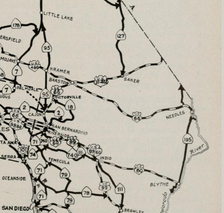
Sign Routes 95 and 195 as placeholders for the US Route 95 family?
Sign Route 95 and 195 were assigned to north/south corridors in the desert regions. It is unclear if this was coincidental or by design, but Sign State Route 95 became part of US Route 395 whereas Sign State Route 195 largely became part of US Route 95. It is unclear why Sign State Route 127 was assigned said number between Sign State Route 95 and Sign State Route 195.
Sierra Nevada Mountains/San Joaquin Valley/Coast Ranges East/West Grouping
Originating in Stockton at Sign State Route 104 the three digit east/west Sign State Routes ascended southward towards Visalia as 108, 120, 132, 140, 152, 168, 180 and 198. Many of the Sign State Routes between Stockton and Visalia were aligned over major passes in the Sierra Nevada Mountains. From Visalia the Sign State Routes descended southward to the Coast Range areas near Los Angeles as 190, 178, 166, 150, 138, 126 and 118.
Sign State Route 111 and US Route 99
Sign State Route 111 appears to have been designated to mirror the existing corridor of US Route 99 through the Sonoran Desert region near Palm Springs south towards El Centro.


Comments