California State Route 19 is a Sign State Highway located in the Los Angeles which is sporadically signed between California State Route 1 at Los Alamitos Traffic Circle in Long Beach north to Interstate 210 near Pasadena. Traditionally California State Route 19 followed Lakewood Boulevard and Rosemead Boulevard in the Long Beach-Pasadena corridor. Presently much of California State Route 19 has been relinquished from State Maintenance but remains signed in places. The current Legislative Definition of California State Route 19 is from the northern city limit of Lakewood north to Gardendale Street/Forest Street along the boundary of Bellflower/Downey. California State Route 19 is also partially signed over what is designated as California State Route 164. California State Route 164 is legislatively defined as Rosemead Boulevard near Pico Rivera north to South El Monte in the vicinity of Rush Street.
Featured above as the blog cover is California State Route 19 signage displayed approaching Los Alamitos Traffic Circle along northbound California State Route 1 in Long Beach. Below California State Route 19 can be seen on the 1963 Division of Highways Map prior to the 1964 State Highway Renumbering.
Part 1; the history of California State Route 19 and unsigned California State Route 164During 1933 the legislative barriers preventing the Division of Highways from maintaining urban highways was removed. Subsequently numerous urban highways were added to the State Maintenance Inventory as new Legislative Routes. What would become California State Route 19 (CA 19) was added as Legislative Route Number 168 (LRN 168). The initial definition of LRN 168 was LRN 60 near Long Beach north to LRN 9 near Lamanda Park.
An early feature of LRN 168 to be completed was its southern terminus in Long Beach at Los Alamitos Traffic Circle. Los Alamitos Traffic Circle opened during 1934 and likely is the second such design constructed in California (the first being the Belmont Traffic Circle of US Route 99 in Fresno).
The initial run of Sign State Routes were announced in the August 1934 California Highways & Public Works. CA 19 was announced as running almost entirely concurrent to LRN 168 from CA 3/LRN 60 in Long Beach north to US Route 66/LRN 161 near Lamanda Park (US Route 99 would move to LRN 26 in September 1934).
The 1935 Division of Highways Maps of Los Angeles County provide detail as to the location and naming of the initial alignments of CA 19/LRN 168. On the southern segment insert CA 19/LRN 168 can be seen originating from Los Alamitos Traffic Circle in Long Beach northward on Bennett Avenue.
The southern segment of the 1935 California Division of Highways Map of Los Angeles County shows CA 19/LRN 168 following Cerritos Avenue north of Carson Street through Bellflower. CA 19/LRN 168 can be seen following a jog on Compton Boulevard to a disconnected segment of Cerritos Avenue towards CA 10/LRN 174 in Downey.
The
January 1935 California Highways & Public Works announced the funding for construction of the new alignment of CA 19/LRN 168 on Rosemead Avenue from US Route 101/LRN 2 at Whittier Boulevard north to LRN 9 at Foothill Boulevard had been allocated (note, it is unclear if CA 19 signage ever extended north of US Route 66/LRN 161).
The
July 1936 California Highways & Public Works announced several segments of CA 19/LRN 168 were still under construction the 87th/88th Fiscal Year. The first project zone is stated to be between Longden Avenue to Fairview Avenue. The second project zone is stated to be from Firestone Boulevard to Telegraph Road. The third project zone consisted of segments of Rosemead Boulevard.
The
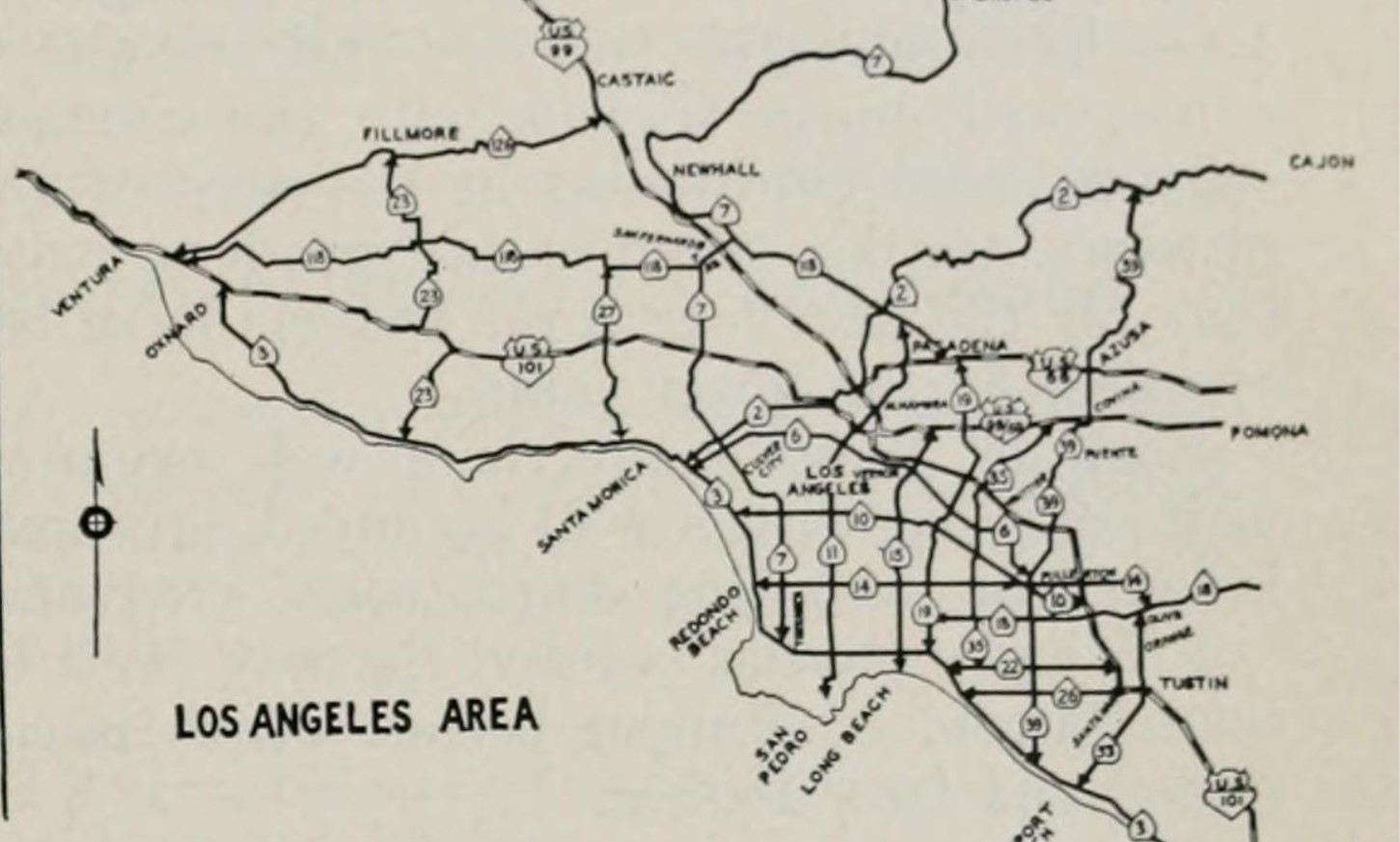
1938 Division of Highways Map shows CA 19/LRN 168 following Lakewood Boulevard from US Route 101A/LRN 60 at Los Alamitos Traffic Circle north CA 10/LRN 174 at Firestone Boulevard in Downey. North of Downey CA 19/LRN 168 is displayed as following Rosemead Boulevard to US Route 66/LRN 161 at Foothill Boulevard.


The
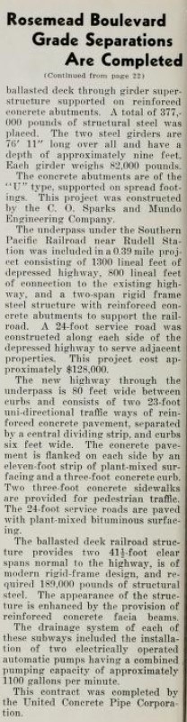
December 1938 California Highways & Public Works features numerous railroad grade separations on CA 19/LRN 168 on Rosemead Boulevard. A Southern Pacific Railroad underpass near Ruddell Station one mile north of Rosemead along with a Union Pacific Railroad underpass near Pico Rivera and US Route 101/Whittier Boulevard are stated to have been completed during the previous November. CA 19/LRN 168 is stated to be approximately 26 miles long and fully completed to modern standards. Cerritos Avenue is stated to have been renamed as Lakewood Boulevard and the portion of San Gabriel Boulevard now part of new alignment of CA 19/LRN 168 is stated to have been renamed as part of Rosemead Boulevard.


The
June 1942 California Highways & Public Works announced Los Alamitos Traffic Circle had been expanded and widened. The article stub notes Los Alamitos Traffic Circle was constructed with the concept of having six highways enter it but only three were constructed. Los Alamitos Traffic Circle had been expanded with an outer ring which had been built by the city of Long Beach and Los Angeles County. The original inner Los Alamitos Traffic Circle was expanded to increase capacity on US 101A/LRN 60 and by proxy traffic departing onto CA 19/LRN 168/Lakewood Boulevard. Completion of the upgrades to Los Alamitos Traffic Circle was completed on April 20th, 1942.


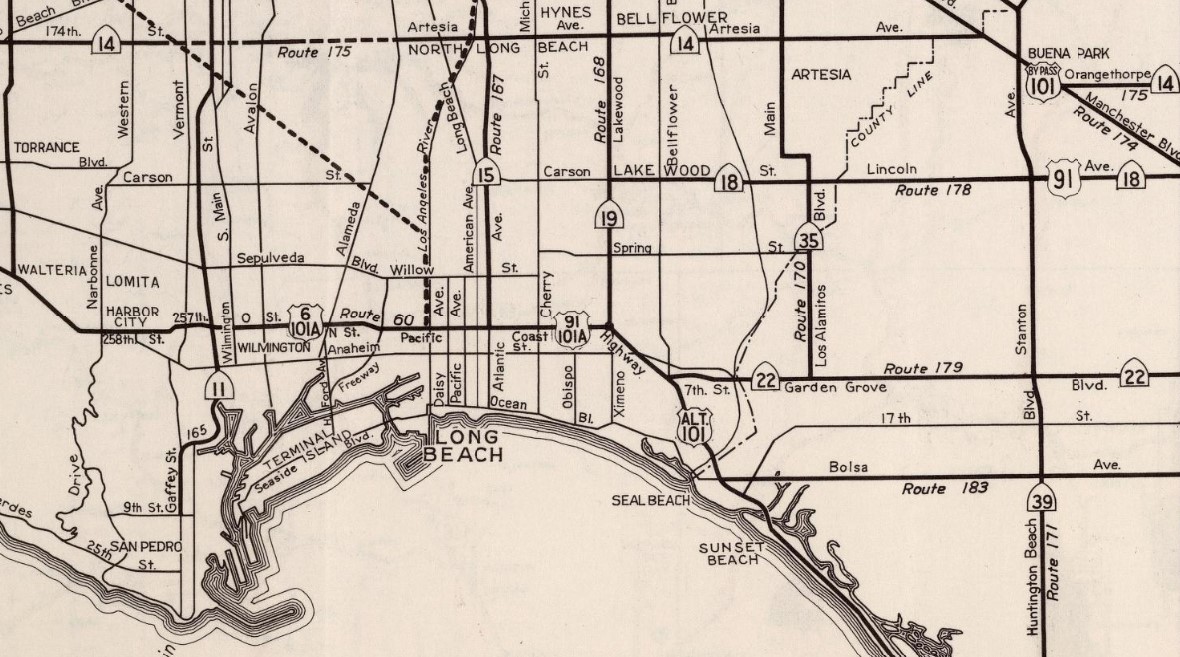
On July 1st, 1947, the AASHO Executive Secretary notified the California State Highway Engineer that California's request to extend US Route 91 from Barstow to Long Beach had been approved. The extension of US Route 91 to Long Beach brought it into the city via multiplex of CA 19/LRN 168 from CA 18/Carson Street south to Los Alamitos Traffic Circle and west on US Route 101A/LRN 60 on Pacific Coast Highway.
US Route 91 can be seen multiplexing CA 19/LRN 168 south from CA 18/Carson Street to Los Alamitos Traffic Circle on the
1948 Division of Highways Map City Insert.
The
January/February 1950 California Highways & Public Works features the progression of CA 19/LRN 168 to a modern divided four lane arterial highway. Much of the progression of Lakewood Boulevard and Rosemead Boulevard from their inception to modern highways is briefed. A then recent project on Rosemead Boulevard from Bellflower Boulevard to Beverely Boulevard is discussed.
The
March/April 1952 California Highways & Public Works provides an update to the progress of construction pertaining to US 99/US 60/US 70/LRN 26 on the Ramona Freeway. The Ramona Freeway grade separation with CA 19/LRN 168 at Rosemead Boulevard is stated to have been completed by September 1951. The articles states that the Ramona Freeway would be upgraded to full freeway standards between the Aliso Street Bridge and CA 19/Rosemead Boulevard by Fall 1953.
The
March/April 1954 California Highways & Public Works features the extension of the Ramona Freeway (US Route 99-60-70/LRN 26) to CA 19/LRN 168 at Rosemead Boulevard. The extension of the Ramona Freeway to Rosemead Boulevard is stated to have opened to traffic on February 16th, 1954.
Los Alamitos Traffic Circle can be seen below in a photo dated to 1956.
The
1957 Division of Highways Map displays CA 18 being extended south of Carson Street via US Route 91/CA 19/LRN 168 to Los Alamitos Traffic Circle and westward via US Route 101A/US Route 91/LRN 60 to Long Beach. It is unclear why CA 18 was extended via the already existing multiplex of US Route 91/CA 19 on LRN 168.
1959 Legislative Chapter 1062 defined LRN 271 as a new state highway between CA 19/LRN 168 and CA 35/LRN 170 in the vicinity of Pico Rivera. LRN 271 can be seen for the first time on the
1960 Division of Highways Map. LRN 271 was an initial addition to the Freeways and Expressways System when it was created during 1959.
US Route 91/CA 19/CA 18/LRN 168 via a recently realigned Lakewood Boulevard can be seen crossing under a runway at Long Beach Municipal Airport and the Interstate 405/San Diego Freeway construction zone in the
March/April 1961 Public Works.
The
1962 Division of Highways Map displays CA 18 truncated from Long Beach to San Bernardino. The truncation of CA 18 removed it from Los Alamitos Circle, a lengthy multiplex of US Route 91 and CA 19 on LRN 168/Lakewood Boulevard.
During the 1964 State Highway Renumbering the Legislative Route Numbers were dropped. CA 19 was given a new definition of "Route 1 near Long Beach to Route 164 near Pico Rivera."
CA 164 was given a definition of "Route 605 near Pico Rivera to Route 210 near Pasadena." CA 164 is shown on the
1964 Division of Highways Map incorporating the planned segment of what was LRN 271. CA 164 on Rosemead Boulevard north of Pico Rivera is shown to still be signed as CA 19.


"CA 164 was to be a stand-alone sub-regional freeway (variously called the "Rosemead", "Santa Anita", and "Sierra Madre" freeways. It was to effectively subsume the northern portion of (then) SSR 19 north of the Whittier Narrows; it would have terminated at I-605 north of the Beverly Blvd. exit and headed northwest near the Narrows dam, coming close to Rosemead Blvd just south of CA 60. It was intended to serve as a "cutoff" from I-605 to Pasadena. There was never any intent to extend it further south along CA 19; south of Whittier Narrows it was always intended to remain a surface facility. Within the scope of the 1964 renumbering the Division of Highways elected to make the whole freeway corridor one individual route; it was subsequently assigned the number [i]164[/i]. Apparently there was no intention of ever signing 164 until such time as the freeway was (a) adopted and (b) constructed -- neither of which ever happened. In 1969, when D7 (which included O.C. at the time) was busy slapping shields on any and all facilities under their aegis, some signage crew took the number 164 literally and manufactured and erected a limited number of small/medium green signs with a 164 spade in place of 19; these were deployed on the C/D roads at the I-10/Rosemead cloverleaf as well as at the foot of the Rosemead ramps on CA 60. At the time I was still attending UCR and passed through that area a couple times a month en route to my home in Glendale; my reaction to seeing the signs was definitely WTF?, prompting a phone call to my cousin who worked at DOH's Sacramento HQ. He said he'd contact D7 to see what was up -- and the answer was a misunderstanding with the field crews tasked with replacing the old original white-on-black signs that had hung around since the mid-'50's. The 164-shielded green signs on the CA 60 ramps were gone by late 1970, while the ones on I-10 hung around for at least another year and a half. Eventually all were replaced by CA 19 signs, since that was the signed route at the time. So far, that's been the extent of any driving-public-related reference to CA 164, although the bridge inventory signs and mileposts on Rosemead north of the Narrows dam reflected the legislated route, which still carried CA 19 reassurance shields."
Despite the CA 164 signage installations cited above CA 19 can still be seen as signed over the existing routing of the highway on Rosemead Boulevard north of CA 60 on the
1970 Division of Highways Map.
CA 19 within the City of Long Beach was relinquished as a State Highway pursuant to terms of a cooperative agreement between the City and California Transportation Commision. The relinquishment of CA 19 in Long Beach was authorized by Assembly Bill 2132, Chapter 877 on September 26th, 1998. CA 19 was relinquished within the City of Downy via Senate Bill 803, Chapter 172 on July 23rd, 1999. The Cities of Long Beach and Downey does not appear to be held to a stipulation to maintain continuation signage until the entirety of CA 19 was relinquished.
The legislative definition of CA 19 was changed by Assembly Bill 535, Chapter 177 on August 4th, 2003 to the following:
From Route 1 near Long Beach to Route 164 near Pico Rivera, excepting the following portions once they have been relinquished by appropriate agreements:
(1) The portion of Route 19 that is between Del Amo Boulevard in the City of Long Bach and Route 1. Relinquished by cooperative agreement.
(2) The portion of Route 19 between Gardendale Street and Telegraph Boulevard with the City of Downey, upon the approval of the California Transportation Commission.
Upon relinquishment, the definition of Route 19 will be:
(1) Del Amo Boulevard near Long Beach to Gardendale Street in Downey.
(2) The Downey city limit at Telegraph Road to Route 164 (Galatin Road) near Pico Rivera.
Senate Bill 1375, Chapter 396, on September 9th, 2004, changed the definition of CA 164 to the following:
(1) Gallatin Road near Pico Rivera to the northern city limit of Temple City in the vicinity of Callita Street and Sultana Avenue.
(2) The northern city limit of Temple City in the vicinity of Callita Street and Sultana Avenue to the southern city limit of the City of Pasadena.
According to cahighways.org the definition of Senate Bill 1375 explicitly permitted the relinquishment of CA 164 to Los Angeles County as described in segment (2). Senate Bill 1375 stipulated that CA 164 remain signed until the entire route was relinquished.
Much of segment (2) of CA 164 was relinquished during October 2006. This action was followed up by Senate Bill 910, Chapter 218 on September 21st, 2007, by which authorized the relinquishment of CA 164 withing Temple City subject to the approval of the California Transportation Commission.
Senate Bill 1318, Chapter 421 on September 29th, 2010, changed the definition of Segment (2) of CA 164 to:
(2) Route 210 to Foothill Boulevard in the City of Pasadena.
Senate Bill 1381, Chapter 421 and Senate Bill 993, Chapter 499 on September 29th, 2010, changed the definition of CA 19 and accounted for the highway being up for relinquishment in Pico Rivera during 2004:
(1) From Del Amo Boulevard near Long Beach to Gardendale Street/Foster Road in the Cities of Bellflower and Downey.
CA 19 within the City of Lakewood was relinquished as a State Highway during March 2012. Senate Bill 788, Chapter 525 on October 9th, 2013, changed the definition of CA 19 to the following:
(1) Route 19 is from the northernly city limit of the City of Lakewood to Gardendale Street/Foster Road in the Cities of Bellflower and Downey.
(2) If the commission determines it is in the state's best interest to do so, it may do the following, pursuant to a cooperative agreement between the respective city and the department:
(A) Relinquish to the City of Bellflower the portion of Route 19 between the city's southerly city limit near Rose Avenue and Gardendale Street/Foster Road.
(B) Relinquish to the City of Downey the portion of Route 19 between the city's southerly city limit at Century Boulevard and Gardendale Steet.
(3) A relinquishment under this section shall become effective when the county recorder records the relinquishment resolution containing the commissioner's approval of the relinquishment terms and conditions.
(4) Any portion of Route 19 relinquished pursuant to this section shall cease to be a state highway on the effective date of the relinquishment.
(5) The relinquished former portions of Route 19 in the Cities of Downey, Lakewood, Long Beach and Pico Rivera are not state highways and not eligible for adoption under Section 81. For the relinquished formation portions of Route 19, the Cities of Downey, Lakewood, Long Beach, and Pico Rivera shall maintain within their respective jurisdictions signs directing motorists on the continuation of Route 19. The City of Lakewood shall ensure the continuity of traffic flow on the relinquished former portion of Route 19, including any traffic signal progression.
Senate Bill 461, Chapter 575 on October 7th, 2015, authorized the relinquishment of specific portions of CA 164 to Los Angeles County and the City of South El Monte. The route definition of CA 164 was changed to the following:
(1) Gallatin Road near Pico Rivera to the southern city limit of South El Monte in the vicinity of Rush Street.
(2) The southern city limit of South El Monte in the vicinity of Rush Street to southern city limit of El Monte in the vicinity of the Rio Hondo River.
(3) The southern city limit of El Monte in the vicinity of the Rio Hondo River to the southern city limit of Temple City in the vicinity of Grand Avenue.
(4) Route 210 to Foothill Boulevard in the City of Pasadena.
Senate Bill 461, Chapter 575 on October 7th, 2015, provided a vehicle to relinquish the remaining segments of CA 164. To date as of April 1st, 2022, the definition of CA 164 has not changed. 3.43 miles of CA 164 on Rosemead Boulevard are presently shown as active State Highway in the Caltrans Postmile Tool.
During May 2017 the California Transportation Commission relinquished the right of way of CA 19 in the City of Bellflower from the south city limit near Rose Street to the north city limit at Gardendale Street. During December 2019 the California Transportation Commission authorized relinquished the right of way of CA 19 in the City of Downey. Presently nothing from CA 19 is showing as active in the Caltrans Postmile Tool.
Part 2; exploring California State Route 19
As noted in the intro CA 19 is still signed from CA 1 northbound in Long Beach approaching Los Alamitos Traffic Circle.
Notably CA 19 is not signed in Los Alamitos Traffic Circle approaching Lakewood Boulevard.
CA 19 is not signed on northbound Lakewood Boulevard in Long Beach from Los Alamitos Traffic Circle to Interstate 405.
CA 19/Rosemead Boulevard remains signed from Interstate 5/Santa Ana Freeway.
CA 19/Lakewood Boulevard remain signed from Interstate 405/San Diego Freeway.
CA 164 remains signed as CA 19 approaching the Rosemead Boulevard (southbound) exit on Interstate 210/Foothill Freeway.


Comments