
World Drive and Epcot Center Drive; the weird freeways of Disney World


The grounds of Disney World near Orlando, Florida consist of numerous limited access freeways which connect the annexes of the park.  While Osceola Parkway is the most well known limited access freeway in Disney World others in the form of World Drive and Epcot Center Drive can be found.  Note; if you are looking for a serious overview of Disney World this is not the place to find it.  This blog is decidedly oriented towards the limited access road network of Disney World and may contain several bad jokes.  


A drive on World Drive and Epcot Center Drive

World Drive is the original access road into the Disney World resort which opened alongside the Magic Kingdom during October 1971.  As originally configured World Drive began at US Route 192 in Bay Lake but an extension south to Interstate 4 was later built by Osceola County.  

Eastbound US Route 192 skirts the ESPN Wide World of Sports complex and intersects World Drive in northern Osceola County.  Traffic headed towards Disney World is directed to take northbound World Drive.   


Northbound World Drive initially has MUTCD compliant signage approaching Orange County and Osceola Parkway.  The Orange County Line serves as the boundary of Disney World resort and City of Bay Lake.  Magic Kingdom and Epcot traffic are directed to stay on World Drive northbound.  Traffic headed towards Wide World of Sports, Animal Kingdom and Hollywood Studios is directed to utilize Osceola Parkway.   World Drive does not utilize any Exit numbers despite being mostly a freeway. 


World Drive northbound enters Disney World underneath the archway used as the cover for this blog. 


Guide signage on all three limited access roads in Disney World is purple instead of the standard MUTCD green.  The signage fonts are also far different than what one could normally expect to see on a typical freeway.  Upon crossing under the Disney World archway traffic on World Drive is advised the Magic Kingdom and Epcot are ahead to the north.  World Drive northbound passes under Osceola Parkway.   


The first Exit on World Drive north of Osceola Parkway accesses Buena Vista Drive.  Disney Springs, Epcot Resort Area and Hollywood Studios can be accessed from the Buena Vista Drive Exit.  A large marque for the Tower of Terror can be seen approaching the Buena Vista Drive Exit.  


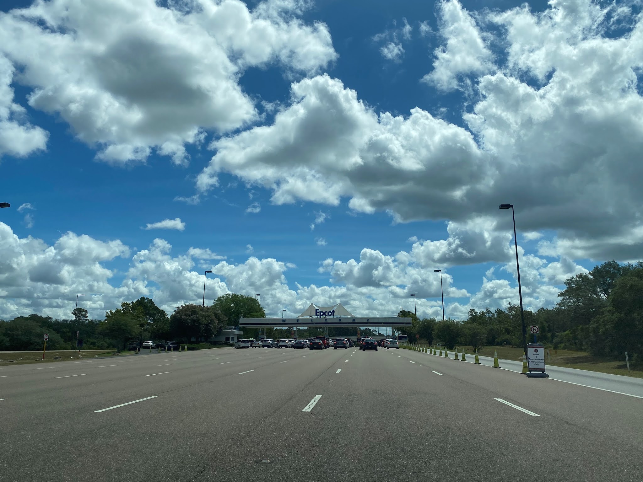
World Drive passes under Buena Vista Drive and approaches the interchange with Epcot Center Drive.  Traffic headed towards the Magic Kingdom is directed to stay on World Drive northward whereas traffic headed towards Epcot is directed to use the Epcot Center Drive ramp eastward.  


Traffic on World Drive northbound cannot access Epcot Center Drive eastbound directly and must pass through the Epcot Visitor Entrance. 


The giant golf ball I'm told people come from all over to see at Epcot. 


I would say Interstate 4 deserves better, but this seems about right. 


The National Transportation Safety Board hasn't released their results from the latest Arosu derailment incident. 


The recently installed Stargate at Epcot.  This almost makes up for the fact that I didn't visit an Orwellian future city.  


I don't like the fact that the Wilkin's Coffee guy has access to a Stargate after all the horrific things he has done to Wontkins. 


Sweet, an overview of all the things I'm missing in Canada.   


Well, sir, there's nothing on earth like a genuine, bona fide electrified, six-car monorail (it wasn't running). 


Departing the Epcot parking lot traffic can turn west or east on Epcot Center Drive.  Westbound Epcot Center Drive traffic is advised it accesses Florida's Turnpike and Florida State Road 429.  Eastbound Epcot Center Drive is advised it serves as access to Interstate 4 and US Route 192. 


Epcot Center Drive was constructed as an access road for Epcot Annex of Disney World during the early 1980s.  Epcot Center Drive east of the Epcot parking lot intersects Backstage Lane which connects to Buena Vista Drive.  Buena Vista Drive is signed as access for all guest areas whereas as Epcot Center Drive is signed as access for; Interstate 4, Florida State Road 536, US Route 192 and Florida State Road 417.  


As Epcot Center Drive eastbound approaches Interstate 4 it gains MUTCD overhead guide signage.  A makeshift US Route 192 and Interstate 4 shield can be spied approaching the east terminus of Epcot Center Drive.  Epcot Center Drive continues as Florida State Route 536 on World Center Drive which directs traffic to Florida State Route 417.  The eastbound exit from Epcot Center Drive empties onto Interstate 4.


Comments

Popular posts from this blog

Former US Route 101 through Sargent

  Sargent is a ghost town and siding of the Southern Pacific Railroad located in southern Santa Clara County.  The original alignment of US Route 101 was aligned through Sargent via what is now known as Old Monterey Road.  Sargent was bypassed gradually due to shifts of the alignment of US Route 101 which occurred during 1941 and 1950.  Pictured as the blog cover is a view on Old Monterey Road which is now no longer accessible to the general public.  Below is a scan of the 1935 Division of Highways Map of Santa Clara County which depicts the original alignment US Route 101 through Sargent.   Part 1; the history of US Route 101 in Sargent Sargent lies on land which was once part of Rancho Juristac.  During 1856 James P. Sargent purchased Rancho Juristac and plotted what was known as Sargent Ranch.  By 1869 the Southern Pacific Railroad coast line reached the relocated town site of Gilroy.  The Southern Pacific Railroad coast line would be constructed through Chittenden Pass by 1871 whic

Tulare Lake returns

During the winter of 2023 California experienced one of the wettest seasons in recent decades.  Enough snow and water were deposited into the Sierra Nevada Mountains that the runoff was enough to partially reform Tulare Lake within San Joaquin Valley.  Tulare Lake was once the largest lake west of the Mississippi River by surface area.  Tulare Lake has been largely dried for the past century due to irrigation divisions and upstream impoundments.  This blog will examine the history of Tulare Lake and its recent return.  Pictured as the blog cover is Tulare Lake from 19th Avenue in Kings County during early May 2023.  Tulare Lake can be seen near its maximum extent below on the 1876 P.Y. Baker Map of Tulare County .   Part 1; the history of Tulare Lake Tulare Lake is the largest remnant of Lake Corcoran.  Lake Corcoran once covered much of the entire Central Valley due to being it being located at a in natural low point from where mountain run-off would accumulate.  Lake Corcoran is thou

US Route 95 in California

US Route 95 within California exists within San Bernardino County and Riverside County.  US Route 95 within California is approximately 130 miles factoring multiplexes along Interstate 10 and Interstate 40.  US Route 95 in California begins at the Arizona state line along the Colorado River near Blythe in Riverside County.  US Route 95 follows the general course of the Colorado River north through the Sonoran Desert to the Mojave Desert towards Needles of San Bernadino County.  US Route 95 enters Nevada north of Interstate 40 and the historic alignment of US Route 66.  US Route 95 was extended to Blythe, California during July 1939.  Upon US Route 95 entering California during 1939 it overlapped and deleted much of the original California State Route 195.  US Route 95 was extended from Blythe into Arizona during June 1960.   Part 1; the history of US Route 95 in California The corridor of modern-day US Route 95 in California first came to prominence during the run-up to the creation of