
Former US Route 101 and California State Route 1 in San Luis Obispo

Originally US Route 101 upon descending Cuesta Pass southbound entered the City of San Luis Obispo via Monterey Street.  From Monterey Street US Route 101 utilized Santa Rosa Street and Higuera Street southbound through downtown San Luis Obispo.  Upon departing downtown San Luis Obispo US Route 101 would have stayed on Higuera Street southward towards Pismo Beach and Arroyo Grande.  Notably; beginning in 1934 US Route 101 picked up California State Route 1 at the intersection of Monterey Street/Santa Rosa Street where the two would multiplex to Pismo Beach.  Pictured below is the 1935 Division of Highways Map of San Luis Obispo County depicting the original alignments of US Route 101 and California State Route 1 in the City of San Luis Obispo.  


Part 1; the history of US Route 1 and California State Route 1 in San Luis Obispo

San Luis Obispo lies at the bottom of the Cuesta Pass (also known as the Cuesta Grade) which has made it favored corridor of travel for centuries.  Cuesta Pass was a long known way through Santa Lucia Range between the coastal areas near San Luis Obispo north into the Salinas River Valley by the local Chumash Tribes of Southern California.  During September of 1769 Portola Expedition of Las Californias the Spanish actually missed Cuesta Pass and opted to attempt to travel up the coast through the Big Sur Region.  The Portola Expedition ultimately found the terrain impassable at Ragged Point and traveled northeast up San Carpoforo Creek to San Antonio Valley near modern day Jolon.  The Spanish didn't discover Cuesta Pass until it was located during a 1774 expedition led by Juan Bautista de Anza.  The route over Cuesta Pass was solidified by the Second Expedition by Juan Bautista de Anza in 1775-1776.   The route of the expeditions led by Juan Bautista de Anza solidified what would become the route of El Camino Real (The Royal Road).

The route of El Camino Real was intended to solidify a path of travel between the Catholic Missions of Las Californias.  In 1804 Alta California was formed out of the larger Las Californias.  El Camino Real would ultimately connect 21 Catholic Missions of Alta California ranging approximately 600 miles spanning from Mission San Diego de Alcala in San Diego north to Mission San Francisco Solano in Sonoma.  The Missions of El Camino Real were established from 1769 through 1823.  In the case of Mission San Francisco Solano it was established two years after Mexico had won it's independence from Spain in 1821.  Each Mission was meant to be approximately 30 miles apart from each other which would require a single day of travel by horseback.

Mission San Luis Obispo de Tolosa was the fifth to be established along the path of El Camino Real in 1772.  Following the expeditions of Juan Bautista de Anza the route north from Mission San Luis Obispo de Tolosa was known as the "Padre Trail.".  Following the secularization of Mission San Luis Obispo de Tolosa (as well as the other Missions) in August of 1833 the land holdings were split off into Ranchos.  Despite El Camino Real functionally no longer existing the route up the Padre Trail through Cuesta Pass remained popular.  The City of San Luis Obispo quickly grew around the former land holdings of Mission San Luis Obispo de Tolosa.  Alta California was annexed by the United States in early 1848 and San Luis Opispo became the first incorporated City in the newly formed San Luis Obispo County in 1850.  Cuesta Pass and the Padre Trail from San Luis Obispo north to Rancho Santa Margarita are clearly seen on the 1857 Britton & Rey Road Map of California. 


Pertaining to the history of overland travel in Cuesta Pass a far more comprehensive Gribblenation blog on said corridor can be found below:

History of Transportation in Cuesta Pass; El Camino Real, Southern Pacific Railroad and US Route 101

In 1904 the American El Camino Real Association was formed with the goal to mark a modern highway that corresponded to the historical route between the Spanish Missions.  Ultimately the path of American El Camino Real was to be marked by the signature bells the corridor is known by today.  The first bell marking the American El Camino Real was placed in 1906 and it is estimated by 1915 that there may have been anywhere from 158 to 400 placed in-field.  San Luis Obispo, Cuesta Pass and the Mountain Road being along the main highway at the time was signed as part of the American El Camino Real.  The American El Camino Real was one of the earliest analogs of what would become the signed Auto Trails.  The background of the American El Camino Real is covered extensively on CAhighways.org.

CAhighyways.org on the American El Camino Real

The era of State Highway Maintenance through San Luis Obispo would begin with the 1909 First State Highway Bond Act which was approved by voters in 1910.  One of the highways approved through the 1909 First State Highway Bond Act was a 481.8 mile highway originating at the City Limits of San Francisco which terminated in San Diego.  This highway would ultimately come to be known in time as Legislative Route Number 2 ("LRN 2").  In 1913 the Pacific Highway was plotted as a major Auto Trail which had San Luis Obispo along it's planned route.

Early LRN 2/American El Camino Real/Pacific Highway can be seen passing through San Luis Obispo on the 1917 California State Automobile Association Map.

The 1920 Rand McNally Highway Map of California shows El Camino Real and the Pacific Highway following LRN 2 through San Luis Obispo.  

The 1923 Pacific Southwest Trust & Savings Map of San Luis Obispo shows LRN 2 utilizing; Monterey Street, Chorro Street and Higuera Street headed southbound through the City.  Major highways are shown departing LRN 2 at Broad Street southward and Santa Rosa Street northward.  It is unclear when through route of LRN 2 shifted from Chorro Street to Santa Rosa Street.     

The 1924 Rand McNally Map of California shows the California Banff Bee-Line Highway co-signed with the Pacific Highway on LRN 2 through San Luis Obispo. 


The initial draft of the US Route System was approved by the Secretary of Agriculture during November of 1925.  The US Route System within California was approved by California Highway Commission with no changes recommended by January 1926.  The initial alignment of US Route 101 ("US 101") was planned to follow LRN 2 from San Francisco to San Diego via San Luis Obispo.  US 101 is shown on a map published in the 1926 California Highways & Public Works following LRN 2 south from San Francisco towards San Diego.


During November of 1926 the US Route System was approved by the AASHO.  US 101 can be seen aligned through San Luis Obispo on the 1927 National Map Company Sectional Map.

The July/August 1930 California Highways & Public Works lists an extension of LRN 56 from Cambria south to San Luis Obispo as a recommended State Highway adoption.  


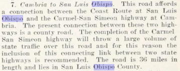
The August 1931 California Highways & Public Works announced the extension of LRN 56 from Cambria southward to San Luis Obispo.  According to CAhighways.org the Cambria-San Luis Obispo extension of LRN 56 was added to the State Highway System as part of 1931 Legislative Chapter 82.  LRN 56 from it's 1931 extension appears to always have entered the City of San Luis Obispo via Santa Rosa Street.   


In 1933 LRN 147 was added to the State Highway System as a route between; "LRN 2 (US 101) near Arroyo Grande and LRN 2 (US 101/CA 1) in San Luis Obispo."  LRN 147 northbound entered San Luis Obispo via Broad Street and terminated at US 101/CA 1/LRN 2 at Higuera Street.  

The August 1934 California Highways & Public Works announced initial run of Sign State Routes.  California State Route 1 ("CA 1") was announced as a highway which followed the entire planned route of LRN 56 from from US 101 in Fortuna back to US 101 at Las Cruces.  CA 1 as originally defined followed LRN 56 into San Luis Obispo via Santa Rosa Street southbound where it picked US 101/LRN 2 at Monterey Street.  US 101/CA 1 as originally defined multiplexed southward via Santa Rosa Street and Higuera Street on LRN 2 through downtown San Luis Obispo towards Pismo Beach. 


As noted in the intro the 1935 Division of Highways Map of San Luis Obispo County depicts the original alignments of US 101 and CA 1 in the City of San Luis Obispo.  

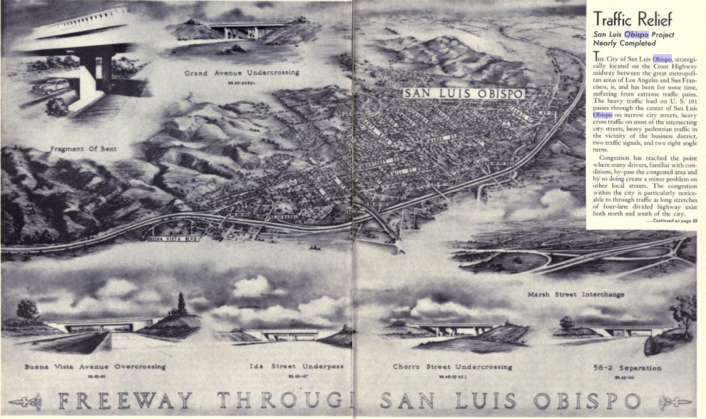
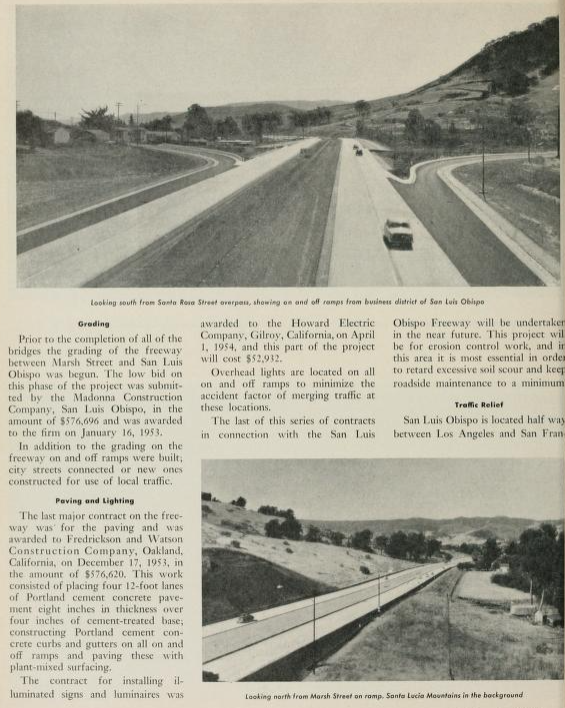
The January/February 1948 California Highways & Public Works announced a new four lane alignment of US 101/CA 1/LRN 2 from Miles Station 6.6 miles north to Marsh Street in San Luis Obispo had recently opened to traffic.  This new segment of four lane US 101/CA 1/LRN 2 realigned both highways northbound onto a new alignment which entered downtown San Luis Obispo via Marsh Street.  Northbound US 101/CA 1/LRN 2 multiplexed on Marsh Street onto Santa Rosa Street towards the split at Monterey Street.  At Monterey Street US 101/LRN 2 departed towards Cuesta Pass whereas CA 1/LRN 56 stayed on Santa Rosa Street towards Morro Bay.  The shift of US 101/CA 1/LRN 2 saw LRN 147 truncated to a new terminus at the intersection of Broad Street and Marsh Street.  


Freeway structures and a new grade bypass grade of downtown San Luis Obispo are displayed as being budgeted for the 1952-53 Fiscal Year in the November/December 1951 California Highways & Public Works.  The scope of the bypass of downtown San Luis Obispo is cited to be from Marsh Street 2.3 miles to San Luis Obispo Creek. 


The July/August 1952 California Highways & Public Works details the upcoming San Luis Obispo Freeway.  A detailed drawing of existing US 101/CA 1/LRN 2 in downtown San Luis Obispo is compared to the upcoming freeway is displayed.  The numerous contracts pertaining to grade separation structures are broken down in detail.   The San Luis Obispo Freeway is cited to have an anticipated opening during 1954.


The July/August 1953 California Highways & Public Works displays the progress of construction on the San Luis Obispo Freeway.  


The September/October 1954 California Highways & Public Works announced the completion and opening of the San Luis Obispo Freeway on August, 27th 1954.  The San Luis Obispo Freeway removed US 101/CA 1/LRN 2 off the surface streets of downtown San Luis Obispo onto a new limited access grade.  Northbound US 101/CA 1/LRN 2 would enter San Luis Obispo on a multiplex to the Santa Rosa Street exit where CA 1 would split towards Morro Bay via LRN 56.  Northbound US 101 continued on LRN 2 towards an existing expressway segment in Cuesta Pass.  LRN 147 was extended via a one-couplet on Higuera Street and Marsh Street to a new terminus at US 101/CA 1/LRN 2.   


US 101/LRN 2 on San Luis Obispo Freeway appears on the back cover of the September/October 1959 California Highways & Public Works.  


During the 1964 California State Highway Renumbering the Legislative Route Numbers were dropped.  LRN 2 simply became legislatively US 101, LRN 56 was changed to CA 1 and LRN 147 became CA 227.  Since 1964 there has been virtually no change to US 101 or CA 1 in San Luis Obispo.  

In 1992 CA 227 was moved onto a new route through southern San Luis Obispo which saw it jog west from Broad Street on South Street to Higuera Street onwards to a terminus at US 101 at Madonna Street.  CA 227 within San Luis Obispo was relinquished to the City during November 2010 according to CAhighways.org.  This relinquishment of CA 227 within San Luis Obispo saw the final piece of the surface alignments US 101/CA 1 removed from the State Highway System.  Part of the relinquishment agreement for CA 227 was that the highway remain signed within the City of San Luis Obispo. 


Part 2; a drive on former US Route 101 and California State Route 1 in San Luis Obispo

Former US 101 and CA 1 through San Luis Obispo can mostly be replicated headed southbound from modern US 101 descending Cuesta Pass.  US 101 Exit 204 accesses it's former alignment on Monterey Street via a jog on Buena Vista Avenue.  


US 101's original alignment would have followed Monterey Street to Santa Rosa Street where it would have intersected CA 1.  Southbound US 101 and CA 1 would have begun a multiplex via left hand turn from Monterey Street onto Santa Rosa Street.  


Former US 101/CA 1 southbound would have  originally quickly transitioned from Santa Rosa Street to Higuera Street via a right hand turn.  From 1948-1954 US 101/CA 1 would have continued on Santa Rosa Street to Marsh Street.  


Former US 101/CA 1 southbound would have originally followed Higuera Street through downtown San Luis Obispo.  Former US 101/CA 1 southbound on Higuera Street intersect the 1948-1954 alignment at the Marsh Street intersection which now also is a onramp to modern US 101.  


Former US 101/CA 1 would have continued south on Higuera Street towards Pismo Beach and Arroyo Grande.  At South Street the signed route of CA 227 is carried on Higuera Street to Madonna Road.  


Comments

Cam said…
Thanks a lot for this route preview. I was trying to decide on this route to Pocatello or staying on the major highway. This route does not seem dangerous.

Camron
Eugene Short said…
Awesome blog you have heree

Popular posts from this blog

Old River Lock & Control Structure (Lettsworth, LA)

  The Old River Control Structure (ORCS) and its connecting satellite facilities combine to form one of the most impressive flood control complexes in North America. Located along the west bank of the Mississippi River near the confluence with the Red River and Atchafalaya River nearby, this structure system was fundamentally made possible by the Flood Control Act of 1928 that was passed by the United States Congress in the aftermath of the Great Mississippi River Flood of 1927 however a second, less obvious motivation influenced the construction here. The Mississippi River’s channel has gradually elongated and meandered in the area over the centuries, creating new oxbows and sandbars that made navigation of the river challenging and time-consuming through the steamboat era of the 1800s. This treacherous area of the river known as “Turnbull’s Bend” was where the mouth of the Red River was located that the upriver end of the bend and the Atchafalaya River, then effectively an outflow

Interstate 10S and the original Interstate 110 in California

Interstate 10S is a short spur of Interstate 10 along San Bernardino Freeway in downtown Los Angeles.  Interstate 10S begins at the Santa Ana Freeway (US Route 101) and extends east to Interstate 5 where it merges into mainline Interstate 10.  Interstate 10S is one of the oldest freeway segments in Los Angeles having been part of US Routes 60, 70 and 99 when it was part of the corridor of the Ramona Expressway.  The current corridor of Interstate 10S was assigned as Chargeable Corridor H following the passage of the 1956 Federal Highway Aid Act.  Interstate 110 was a short-lived designation which comprised the segment San Bernardino Freeway from US Route 101 to Interstate 5 between 1964-1968.  The original Interstate 110 was dropped as a Chargeable Corridor during 1965 and consolidated as Interstate 10S during 1968.   The original Interstate 110 can be seen as the blog cover photo as it was featured on the 1964 Division of Highways Map.  Below the entire 0.65-mile length of Interstate

Vicksburg Bridge (Vicksburg, MS)

  Located a few hundred feet downriver from the Old Vicksburg Bridge, the Vicksburg Bridge, or the “New” Bridge, serves as the city’s vehicular crossing of the Mississippi River on the main highway connecting Vicksburg with northeastern Louisiana to the west and the state capital of Jackson to the east. The completion of the original Vicksburg Bridge in 1930 was seen as a huge success and the bridge proved to be a profitable entity for both road and railroad interests along the path of the Dixie Overland Highway and the subsequent US Highway 80 corridor. In the years after the creation of the National Interstate Highway System, planning commenced on a new bridge at the site that would relieve the congestion on the existing bridge while providing for a more modern crossing of the river that would be safe for all vehicles. The construction of the new bridge at Vicksburg was completed in 1973 and its design intentionally mimics that of its predecessor nearby. This was due in large part