
Paso Robles is a city located on the Salinas River of San Luis Obispo County, California. As originally configured the surface alignments of US Route 101 and California State Route 41 converged in downtown Paso Robles. US Route 101 originally was aligned through Paso Robles via Spring Street. California State Route 41 entered the City of Paso Robles via Union Road and 13th Street where it intersected US Route 101 at Spring Street. US Route 101 and California State Route 41 departed Paso Robles southbound via a multiplex which split near Templeton.
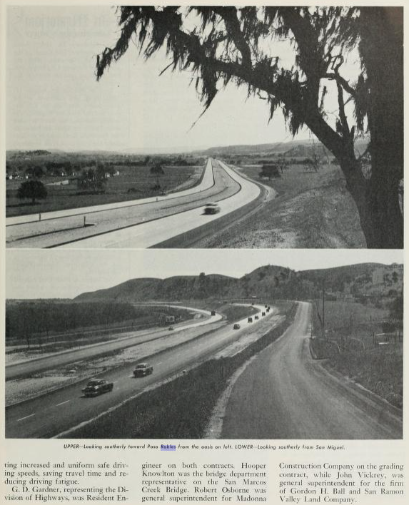
Pictured above is the cover of the September/October 1957 California Highways & Public Works which features construction of the Paso Robles Bypass. Pictured below is the 1935 Division of Highways Map of San Luis Obispo County which depicts US Route 101 and California State Route 41 intersecting in downtown Paso Robles.

In 1857 during the Gold Rush era of American California, Rancho Paso de Robles was purchased by the Blackburn Brothers who sought to exploit the local springs for tourism. This culminated with the opening of the first Paso Robles hotel which was completed by 1864. Rancho Paso de Robles and a nearby hot spring can be seen the main coastal highway on the 1873 Bancroft's Map of California.


The May/June 1955 California Highways & Public Works announced the opening of the US 101/LRN 2 freeway from Paso Robles to San Miguel. The Paso Robles-San Miguel Freeway is stated to be 6.5 miles in length and featured numerous unique for the time design elements.

In 1886 the Southern Pacific Railroad reached the Paso Robles resort. The Southern Pacific Railroad laid out a town site and rail siding facility utilizing the resort as it's center. Paso Robles would begin to grow alongside the Southern Pacific Railroad and would incorporate as a City on March 11th, 1889. Paso Robles can be seen on the 1890 George F. Cram Railroad Map of California alongside the Southern Pacific Railroad.

Paso Robles was ultimately part of the American El Camino Real which began being signed as an Auto Trail starting in 1906. The era of State Highway Maintenance through Paso Robles would begin with the 1909 First State Highway Bond Act which was approved by voters in 1910. One of the highways approved through the 1909 First State Highway Bond Act was a 481.8 mile highway originating at the City Limits of San Francisco which terminated in San Diego. This highway would ultimately come to be known in time as Legislative Route Number 2 ("LRN 2"). In 1913 the Pacific Highway was plotted as a major Auto Trail which had Paso Robles along it's planned route.
During the 1916 Second Highway Bond Act LRN 33 was added to the State Highway System with the following defintion:
"an extension connecting the San Joaquin valley trunk line (LRN 4) at or near Bakersfield with the coast trunk line (LRN 2) in San Luis Obispo County, through Cholame Pass, by the most direct and practical route."
Early LRN 2/American El Camino Real/Pacific Highway and LRN 33 can be seen converging at Paso Robles on the 1917 California State Automobile Association Map.

The 1920 Rand McNally Highway Map of California shows El Camino Real and the Pacific Highway following LRN 2 through Paso Robles.

The 1924 Rand McNally Map of California shows the California Banff Bee-Line Highway co-signed with the Pacific Highway on LRN 2 through Paso Robles.


The initial draft of the US Route System was approved by the Secretary of Agriculture during November of 1925. The US Route System within California was approved by California Highway Commission with no changes recommended by January 1926. The initial alignment of US Route 101 ("US 101") was planned to follow LRN 2 from San Francisco to San Diego via Paso Robles. US 101 is shown on a map published in the 1926 California Highways & Public Works following LRN 2 south from San Francisco towards San Diego.


During November of 1926 the US Route System was approved by the AASHO. US 101 can be seen aligned through Paso Robles on the 1927 National Map Company Sectional Map.

During 1933 LRN 33 had been extended to a new terminus west of Paso Robles at LRN 56 in Cambria. LRN 33 from Cholame west to Cambria was announced as part of California State Route 41 ("CA 41") when the initial run of Sign State Routes were published in the August 1934 California Highways & Public Works. The announcement of CA 41 saw it multiplex US 101 on Spring Street in downtown Paso Robles from 13th Street southward.


As noted in the intro; the 1935 Division of Highways Map of San Luis Obispo County depicts US Route 101 and California State Route 41 intersecting in downtown Paso Robles.
The July/August 1952 California Highways & Public Works announced 9 miles of US 101/LRN 2 north of Templeton to Paso Robles would be expanded to four-lane standards. According to the July/August 1955 California Highways & Public Works the Templeton-Paso Robles segment of US 101/LRN 2 was converted to four-lane standards by Summer 1953.

The November/December 1952 California Highways & Public Works announced US 101/LRN 2 was budgeted for the 1953-54 Fiscal Year to begin the process of freeway conversion from Paso Robles north to San Miguel.


The May/June 1957 California Highways & Public Works announced a new expressway grade for CA 41/LRN 33 east of Paso Robles was in the process of being constructed.

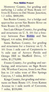
The July/August 1957 California Highways & Public Works announced the upcoming realignment of US 101/LRN 2 on the Paso Robles Bypass. The Paso Robles Bypass Project is stated to be 5.1 miles in length which would tie into the existing divided highway segments on both ends of the City. The Paso Robles Bypass Project included a tie-in with the recently completed realignment of CA 41/LRN 33 from Huerhuero Creek east to the Estrella River.


During June of 1958 the Division of Highways sought and obtained permission to relocate US 466 off of LRN 125 between Atascadero and Shandon. The Division of Highways noted that CA 41/LRN 33 between Paso Robles-Shandon had recently been improved and was by far the favored highway for traffic. LRN 125 between Atascadero-Shandon is noted to be substandard in design and despite being part of US 466 since 1933 was never signed as such. US 101 through Paso Robles is noted to be in the process of going through a freeway upgrade.. The new alignment of US 466 would see it briefly multiplex CA 41/LRN 33 west of Shandon to Paso Robles via 24th Street and US 101/LRN 2 south to Atascadero via Spring Street.


The September/October 1958 California Highways & Public Works notes the Paso Robles Bypass was nearly completed. The Paso Robles Bypass was slated to shift the alignment of US 466/US 101/CA 41 onto a new limited access grade replacing Spring Street.

The November/December 1958 California Highways & Public Works notes the Paso Robles Bypass opened to traffic during November 1958.

The new alignment of US 466 multiplexing CA 41/LRN 33 west of Shandon and US 101/LRN 2 south of Paso Robles is depicted on the 1959 Division of Highways Map.

US 466 was approved for truncation from Morro Bay to CA 127 in Baker by the AASHO Executive Committee during June 1964. This truncation would see US 466 terminate on Baker Boulevard at the intersection with CA 127/Death Valley Road.

During the 1964 California State Highway Renumbering the Legislative Route Numbers were dropped. CA 41 was realigned from Shandon to a new terminus following what was LRN 125 to Morro Bay (US 466 from Atascadero-Morro Bay). What had been CA 41 west of Shandon to Cambria via Paso Robles was added to the new CA 46. The 1965 Division of Highways Map also shows US 466 removed from San Luis Obispo County and US 101/CA 46 multiplexing through Paso Robles.

Part 2; a drive on former US Route 101 and California State Route 41 through downtown Paso Robles
As noted in Part 1 CA 41 and US 466 briefly followed 24th Street to US 101 on Spring Street for several months of 1958 before the Paso Robles Bypass was completed. CA 41 south/US 466 west would have made a left hand turn onto US 101 southbound at Spring Street.

Spring Street in Paso Robles is signed as Historic US 101.


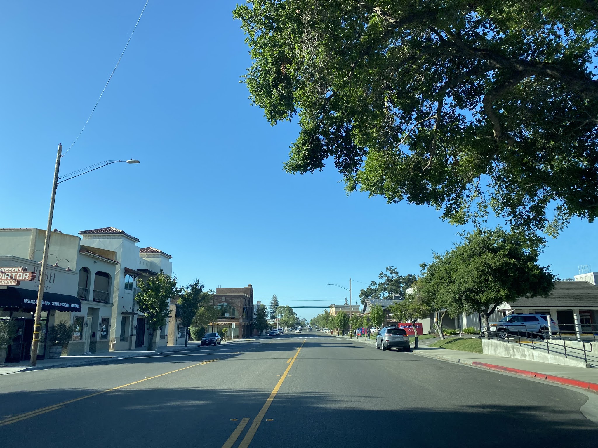


Spring Street south of 13th Street continues through Paso Robles and merges into the southbound lanes of modern day US 101/CA 46 on the Paso Robles Bypass at Niblick Road.


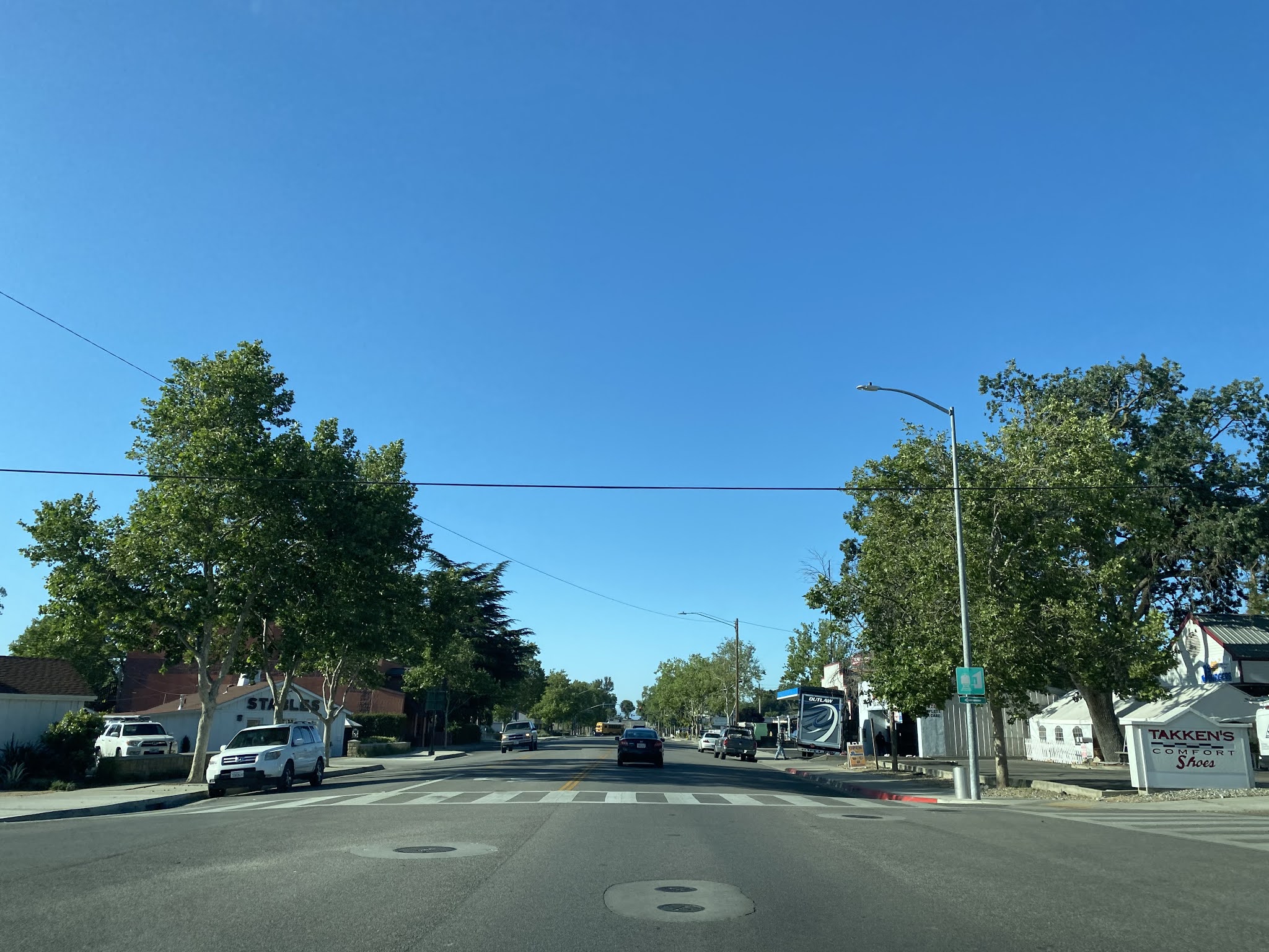


Part 3; a drive on former US Route 101 along Monterey Road north of downtown Paso Robles
A bypassed segment of the original alignment of US 101 north of downtown Paso Robles can be found now as Monterey Road. Monterey Road begins near Stockdale Road just outside the Paso Robles city limit and spans north to near San Marcos Road. The segment passes through the former site of Wellsona siding and features numerous abandoned Portland Cement stubs.


Part 4; a drive on former California State Route 41 from the Estrella River to downtown Paso Robles
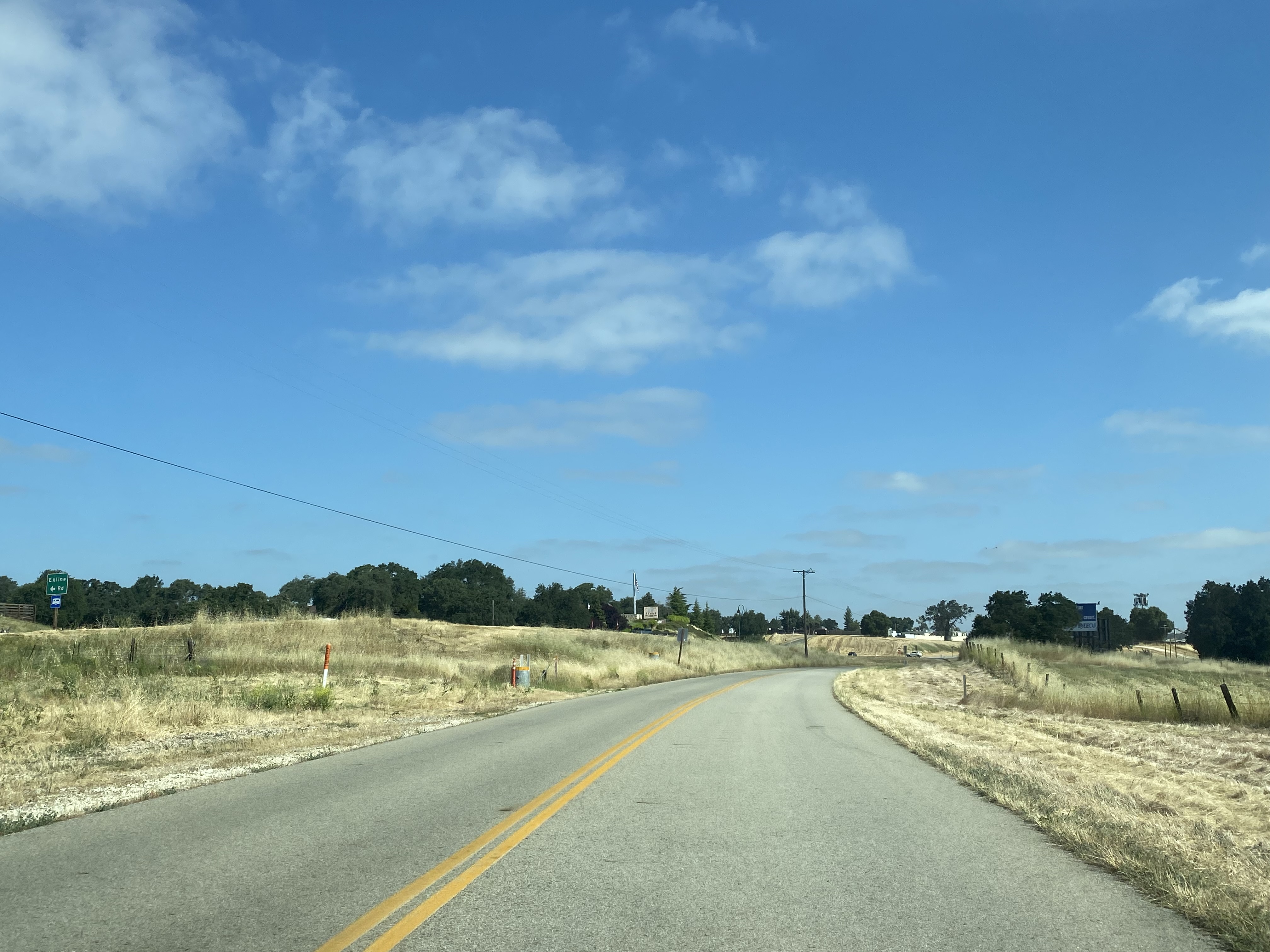
West of the Estrella River former CA 41 approached Paso Robles via what is now Union Road.

Union Road westbound traverses the hills on the outskirts of Paso Robles before making a left-hand turn into the city limit.


CA 41 would have followed Union Road towards the Salinas River and turned onto 13th Street. The figure eight roundabout at Union Road and Golden Hill Road was dedicated on June 23, 2023.


CA 41 would have entered downtown Paso Robles via 13th Street and followed it to US 101 at Spring Street.


Version History
- Originally published on June 20, 2021.
- First updated on May 26, 2024.
Comments