This past month I drove the entirety of California State Route 134 on the Ventura Freeway while visiting the Los Angeles Area.

The present route of CA 134 is a 13 mile east/west State Highway which is entirely aligned on the Ventura Freeway from Interstate 210 in Pasadena to US 101/CA 170 in northern Los Angeles. CA 134 on the Ventura Freeway is the primary through route connecting traffic between San Gabriel Valley and San Fernando Valley. The Ventura Freeway continues on US 101 north from the western terminus of CA 134 through Ventura County to the Santa Barbra County line.
CAhighways.org on CA 134
CA 134 was not one of the original run of 1934 Signed State Highways. By most accounts CA 134 was first signed by 1935 but said year seems to be disputed by an October 1935 Department of Public Works publication and 1935 Goshua Highway Map.
1935 Department of Public Works Publication
1935 Goshua Los Angeles Highway Map
The first true map to display CA 134 was the 1938 State Highway Map City insert.
1938 State Highway Map City Insert
The first alignment of CA 134 appears to have been signed as follows:
- From CA 11/US 66 at Figueroa Street west on Colorado Boulevard/Legislative Route Number 161 to US 6/US 99/LRN 4 on San Fernando Road.
- A multiplex of US 6/US 99/LRN 4 on San Fernando Road to Alameda Avenue.
- LRN 161 on Alameda Avenue to Riverside Drive.
- LRN 161 on Riverside Drive to Moorpark Street.
- LRN 161 on Moorpark Street to Fulton Avenue.
- LRN 161 on Fulton Avenue to US 101 on Ventura Boulevard.
As the Arroyo Seco Parkway was being completed in December 1940/January 1941 the eastern terminus of CA 134 appears to have been extended east over the Arroyo Seco via Colorado Boulevard/LRN 161 to US 66 in downtown Pasadena. CA 134 would have had a brief multiplex of CA 11 from Figueroa Street to Linda Vista Avenue. The western terminus of CA 134 was extended westward on Moorpark Street and Tyrone Avenue to US 101 on Ventura Boulevard.
1940 State Highway Map City Insert
The 1948 State Highway Map City Insert displays the western terminus of CA 134 truncated. CA 134 likely met US 101 via LRN 159/Lankershim Boulevard on a temporary alignment while a new western terminus is shown as planned.
1948 State Highway Map City Insert
The first segment of what was known as the "Colorado Freeway" apparently fully opened in 1954 between Orange Grove Avenue in Pasadena west to Avenue 64 in the Eagle Rock neighborhood of Los Angeles. The Colorado Freeway essentially served as a replacement for the 1913 Colorado Street Bridge. The Colorado Freeway was extended to Eagle Vista Drive by 1955 and More can be found on SoCalregion.com.
SoCalregion.com on the Colorado Freeway
The 1957 State Highway Map City Insert displays the planned western terminus of CA 134 as deleted. CA 134 is shown reaching US 101 via LRN 159/Lankershim Boulevard.
1957 State Highway Map City Insert
The planned route of the CA 134 portion of the Ventura Freeway between modern day I-210 and modern day I-10 was created as LRN 240 in 1957 according to CAhighways.org. The 1958 State Highway Map City insert displays the planned route LRN 240 and the planned portion of the US 101 portion of the Ventura Freeway. Of note; CA 134 was extended to the Golden State Freeway via the Colorado Street Freeway Extension over the Los Angeles River by 1957 which first appears on the 1958 State Highway Map City Insert
CAhighways.org on LRN 240
1958 State Highway Map City Insert
By 1959 US 66A was multiplexed onto CA 134 on Colorado Boulevard from Pasadena to Figueroa Street.
1959 State Highway Map City Insert
The 1961 State Highway Map City insert shows the US 101 portion of the Ventura Freeway complete in Los Angeles. While no change to the alignment of CA 134 is shown a new portion of the planned Ventura Freeway between LRN 159 and LRN 4 is shown.
1961 State Highway Map City Insert
The 1963 State Highway Map City Insert shows CA 134 realigned onto an extension of the Ventura Freeway between LRN 159 and LRN 4.
1963 State Highway Map City Insert
In 1964 the LRNs were changed State wide to reflect signage in-field on State Maintained Highways. LRN 161 became LRN 134 in line with the CA 134 field signage.
1964 State Highway Map City Insert
By 1969 the CA 134 portion of the Ventura Freeway had been extended over Los Angeles River. Despite the extension of the Ventura Freeway the route CA 134 appears to still have been routed down I-5 to Colorado Boulevard.
1969 State Highway Map City Insert
Sometime between 1970 and 1975 CA 134 had moved to a new segment of the Ventura Freeway which had built as far east as earlier alignment of the Colorado Freeway over the Arroyo Seco.
1975 State Highway Map City Insert
By 1977 the full route of the CA 134 portion of the Ventura Freeway appears.
1977 State Highway Map City Insert
With the above history of CA 134 out of the way I approached the route via I-210 westbound in Pasadena.


CA 134 westbound Exit 13B accesses CA 110 via a stub of the incomplete Long Beach Freeway.

Approaching CA 134 west Exit 13A at Orange Grove Boulevard there is historic marker signage for the Gamble House.


CA 134 westbound crosses the Arroyo Seco and has access to San Rafael Avenue via Exit 12.


At Exit 11 CA 134 west meets Colorado Boulevard. The westbound ramp to Colorado Boulevard is a remaining section of the Colorado Freeway.


CA 134 west passes through Eagle Rock before meeting CA 2/Glendale Freeway at Exit 9B. Harvey Drive is accessed via CA 134 west Exit 9A.


At Exit 8 CA 134 accesses Glendale Avenue.

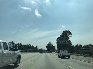
CA 134 west Exit 7B accesses Brand Boulevard whereas Exit 7A accesses Pacific Avenue. Historic signage for Casa Adobe de San Rafael is signed directing traffic to Pacific Avenue.


San Fernando Road is accesses via CA 134 west Exit 6.


CA 134 west crosses the Los Angeles River and has a junction with I-5/Golden State Freeway at Exit 5.


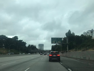
CA 134 west Exit 4 accesses Forest Lawn Drive.

CA 134 west crosses the Los Angeles River and accesses Buena Vista Street via Exit 3.

CA 134 west Exit 2 accesses Hollywood Way.

CA 134 Exit 1D accesses Cahuenga Boulevard. There is a historic sign (poorly placed) alerting traffic that Campo de Cahuenga can be accessed via Cahuenga Boulevard.


CA 134 west Exit 1C accesses Lankershim Boulevard.

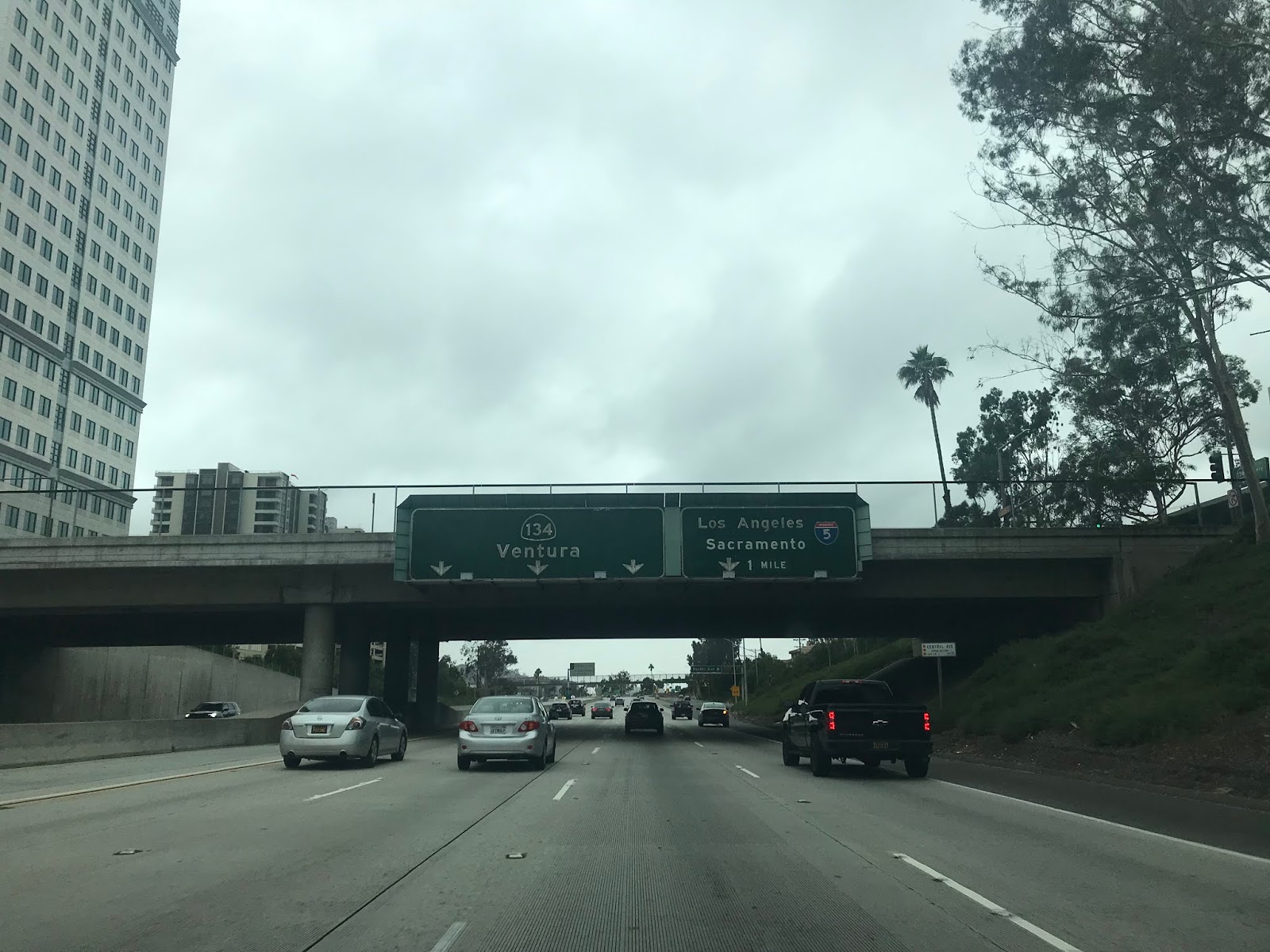
CA 134 west terminates at the junction for US 101 and CA 170. The Ventura Freeway continues onto US 101 northbound whereas the Hollywood Freeway is accessed via CA 170 north and US 101 south.


The present route of CA 134 is a 13 mile east/west State Highway which is entirely aligned on the Ventura Freeway from Interstate 210 in Pasadena to US 101/CA 170 in northern Los Angeles. CA 134 on the Ventura Freeway is the primary through route connecting traffic between San Gabriel Valley and San Fernando Valley. The Ventura Freeway continues on US 101 north from the western terminus of CA 134 through Ventura County to the Santa Barbra County line.
CAhighways.org on CA 134
CA 134 was not one of the original run of 1934 Signed State Highways. By most accounts CA 134 was first signed by 1935 but said year seems to be disputed by an October 1935 Department of Public Works publication and 1935 Goshua Highway Map.
1935 Department of Public Works Publication
1935 Goshua Los Angeles Highway Map
The first true map to display CA 134 was the 1938 State Highway Map City insert.
1938 State Highway Map City Insert
The first alignment of CA 134 appears to have been signed as follows:
- From CA 11/US 66 at Figueroa Street west on Colorado Boulevard/Legislative Route Number 161 to US 6/US 99/LRN 4 on San Fernando Road.
- A multiplex of US 6/US 99/LRN 4 on San Fernando Road to Alameda Avenue.
- LRN 161 on Alameda Avenue to Riverside Drive.
- LRN 161 on Riverside Drive to Moorpark Street.
- LRN 161 on Moorpark Street to Fulton Avenue.
- LRN 161 on Fulton Avenue to US 101 on Ventura Boulevard.
As the Arroyo Seco Parkway was being completed in December 1940/January 1941 the eastern terminus of CA 134 appears to have been extended east over the Arroyo Seco via Colorado Boulevard/LRN 161 to US 66 in downtown Pasadena. CA 134 would have had a brief multiplex of CA 11 from Figueroa Street to Linda Vista Avenue. The western terminus of CA 134 was extended westward on Moorpark Street and Tyrone Avenue to US 101 on Ventura Boulevard.
1940 State Highway Map City Insert
The 1948 State Highway Map City Insert displays the western terminus of CA 134 truncated. CA 134 likely met US 101 via LRN 159/Lankershim Boulevard on a temporary alignment while a new western terminus is shown as planned.
1948 State Highway Map City Insert
The first segment of what was known as the "Colorado Freeway" apparently fully opened in 1954 between Orange Grove Avenue in Pasadena west to Avenue 64 in the Eagle Rock neighborhood of Los Angeles. The Colorado Freeway essentially served as a replacement for the 1913 Colorado Street Bridge. The Colorado Freeway was extended to Eagle Vista Drive by 1955 and More can be found on SoCalregion.com.
SoCalregion.com on the Colorado Freeway
The 1957 State Highway Map City Insert displays the planned western terminus of CA 134 as deleted. CA 134 is shown reaching US 101 via LRN 159/Lankershim Boulevard.
1957 State Highway Map City Insert
The planned route of the CA 134 portion of the Ventura Freeway between modern day I-210 and modern day I-10 was created as LRN 240 in 1957 according to CAhighways.org. The 1958 State Highway Map City insert displays the planned route LRN 240 and the planned portion of the US 101 portion of the Ventura Freeway. Of note; CA 134 was extended to the Golden State Freeway via the Colorado Street Freeway Extension over the Los Angeles River by 1957 which first appears on the 1958 State Highway Map City Insert
CAhighways.org on LRN 240
1958 State Highway Map City Insert
By 1959 US 66A was multiplexed onto CA 134 on Colorado Boulevard from Pasadena to Figueroa Street.
1959 State Highway Map City Insert
The 1961 State Highway Map City insert shows the US 101 portion of the Ventura Freeway complete in Los Angeles. While no change to the alignment of CA 134 is shown a new portion of the planned Ventura Freeway between LRN 159 and LRN 4 is shown.
1961 State Highway Map City Insert
The 1963 State Highway Map City Insert shows CA 134 realigned onto an extension of the Ventura Freeway between LRN 159 and LRN 4.
1963 State Highway Map City Insert
In 1964 the LRNs were changed State wide to reflect signage in-field on State Maintained Highways. LRN 161 became LRN 134 in line with the CA 134 field signage.
1964 State Highway Map City Insert
By 1969 the CA 134 portion of the Ventura Freeway had been extended over Los Angeles River. Despite the extension of the Ventura Freeway the route CA 134 appears to still have been routed down I-5 to Colorado Boulevard.
1969 State Highway Map City Insert
Sometime between 1970 and 1975 CA 134 had moved to a new segment of the Ventura Freeway which had built as far east as earlier alignment of the Colorado Freeway over the Arroyo Seco.
1975 State Highway Map City Insert
By 1977 the full route of the CA 134 portion of the Ventura Freeway appears.
1977 State Highway Map City Insert
With the above history of CA 134 out of the way I approached the route via I-210 westbound in Pasadena.


CA 134 westbound Exit 13B accesses CA 110 via a stub of the incomplete Long Beach Freeway.

Approaching CA 134 west Exit 13A at Orange Grove Boulevard there is historic marker signage for the Gamble House.


CA 134 westbound crosses the Arroyo Seco and has access to San Rafael Avenue via Exit 12.


At Exit 11 CA 134 west meets Colorado Boulevard. The westbound ramp to Colorado Boulevard is a remaining section of the Colorado Freeway.


CA 134 west passes through Eagle Rock before meeting CA 2/Glendale Freeway at Exit 9B. Harvey Drive is accessed via CA 134 west Exit 9A.


At Exit 8 CA 134 accesses Glendale Avenue.

CA 134 west Exit 7B accesses Brand Boulevard whereas Exit 7A accesses Pacific Avenue. Historic signage for Casa Adobe de San Rafael is signed directing traffic to Pacific Avenue.


San Fernando Road is accesses via CA 134 west Exit 6.


CA 134 west crosses the Los Angeles River and has a junction with I-5/Golden State Freeway at Exit 5.


CA 134 west Exit 4 accesses Forest Lawn Drive.

CA 134 west crosses the Los Angeles River and accesses Buena Vista Street via Exit 3.

CA 134 west Exit 2 accesses Hollywood Way.

CA 134 Exit 1D accesses Cahuenga Boulevard. There is a historic sign (poorly placed) alerting traffic that Campo de Cahuenga can be accessed via Cahuenga Boulevard.


CA 134 west Exit 1C accesses Lankershim Boulevard.

CA 134 west terminates at the junction for US 101 and CA 170. The Ventura Freeway continues onto US 101 northbound whereas the Hollywood Freeway is accessed via CA 170 north and US 101 south.

Comments