
For decades now, the 33 or so miles of Interstate 70 between New Stanton and Washington, Pennsylvania has been miles of narrow highway with nothing but a concrete (prior to that a steel guard rail) median separating high-speed Interstate traffic. The ramps at nearly all the interchanges have no acceleration or deceleration ability - in fact, nearly all on-ramps to I-70 have a stop sign with them. Narrow lanes and shoulders and low-speed limits.
Well, the good news - PennDot short of building a new Interstate 70 (I will get to that history some other time) is doing some much-needed improvements throughout this stretch of highway. As of this blog entry in November 2015, the Smithton (Exit 49) and PA 519 (Exit 25) interchanges have been redone and the PA 917, PA 481 and New Stanton interchange rebuilds are underway. Further plans are to improve the interchanges with PA 51, PA 31, and Yukon/Wyano within the next five years.
But these aren't the first wide-scale improvements done to Interstate 70 to bring the highway up to interstate standards (or at least to a minimum standard). In the late 1950s, an aggressive campaign saw the closure of numerous at grades, the addition of four new interchanges, and the redesign of a few others. This was all done to allow the Interstate 70S designation to be applied to the then less than five-year-old PA 71.
Again, the great website, Penn Pilot, is the source of all aerial photographs. We will travel East to West - starting at the PA 31 interchange. The aerial photos from the late 50s do not show any construction east of the PA 31 interchange.
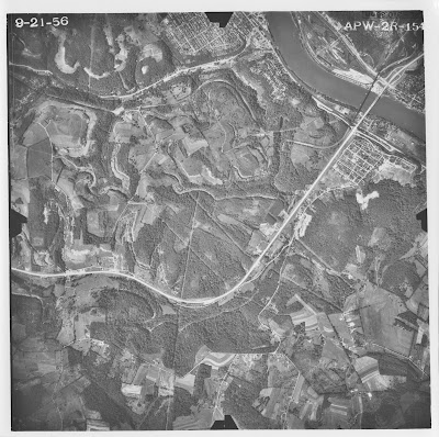
 Construction of the PA 31 interchange (Exit 51) in September 1957. The ROW clearing for the highway ends just off the upper right-hand corner of the photo. This section of the highway was built with fully controlled access.
 The next interchange east is the Smithton interchange. (Exit 49) This interchange was just recently redesigned and rebuilt as part of the I-70 Improvements Project. The Youghiogheny River Bridge is still under construction. This bridge was last rehabbed in the late 1990s.
 A 1956 view of the PA 51 cloverleaf interchange (Exit 45). PA 51 runs on its original two-lane alignment with the exception of the newly built interchange. My thought has always been that both occurred together. Here is where you can begin to see some of the at-grades that were on PA 71 at the time. An at-grade at Nichols Hill Road exists to the east of PA 51. Today, Nichols Hill Road is named for the road north of I-70 and Springs Road runs south of the Interstate. I am not sure what the oval track was for (horses? stock cars?)
 Compare the same area to a May 1967 image. The at-grade with Nichols Hill Road is removed and replaced with a bridge to the east that connects Crawford Lane to Finley Road. PA 51 is now four lanes and the racing oval is still there. Cedarbrook Golf Club (Editors note: I have played golf here numerous times in my life.) is now open - but its expansion and corresponding tunnel underneath the highway to the north end of I-70 won't occur for another 22 years.
 In 1956, the Arnold City interchange (Exit 44) didn't exist. Indian Hill Road was an at-grade crossing. Also, south of the four-lane highway, it appears that Finley Road (former alignment of PA 981) joins and leaves the new PA 71 between Indian Hill Road and the Pricedale Interchange (PA 201/Exit 43).
 This 1959 aerial photo shows the Arnold City interchange clearly under construction. A new alignment of Finley Road is also being built which will eliminate those two at-grades. You can also see at the uppermost right-hand corner, the overpass that carries Crawford Lane (replacing the Nichols Hill Road at grade) has been built.
 Finally, a 1967 look at Interstate 70 at the Arnold City Interchange. You can clearly make out the old alignments and changes to the rural two-lane roads around I-70.
The next four aerials will cover the area between the PA 201 and PA 906 exits. These are the Pricedale, Monessen, North Belle Vernon, and Belle Vernon Interchanges. (Exits 43, 42A, 42, and 41).
 This first image is from September 1956. Going right to left, the Pricedale and Monessen interchanges are in place. The old Super 71 Drive-In theater is south of the interchange. This drive-in lasted into the 1980s and was the last reference to the old PA 71 designation along I-70.
You will see that the trumped interchange for North Belle Vernon (Exit 42) is not in place. It appears that a series of at grades existed on the north end of the town. Case in point, the subdivision that is along Ferncliff Drive to the north of I-70 is at-grade. Later, a bridge carrying Baltimore Street to Ferncliff Drive would be built.
 A clearer view of the residential street at-grades in North Belle Vernon can be seen in the above 1958 aerial. At the time of the photo, it appears no work has started on the North Belle Vernon interchange.
 By 1959, things were beginning to change. The bridge connecting the Ferncliff Drive subdivision to Baltimore Street and the town had been built. Also, the grading work for the North Belle Vernon interchange is well underway. The connections to the homes along Beacon and Washington streets were also being built.
 Here's a look at the finished product in 1967. All interchanges are in place - the Super 71 is still there. Interestingly though, the early shopping centers (K-Mart, Hills) at the Pricedale interchange are not there yet. The image also gives you an idea of why this part of 70 seems shoehorned into the terrain.
Now, let's cross the Speers Bridge and Monongahela River and take a look at the Charleroi and Speers Interchanges (Exits 40 and 39). This is also a four-image progression.
This image from September 1956 shows quite a few items. First, if you are headed eastbound and about to cross the Speers Bridge, it appears that there are a few extra ramps at the Charleroi (PA 88) interchange. It looks to be that there is a ramp to the subdivision that overlooks the new highway and that a U-Turn type ramp connects the subdivision to the ramp down to PA 88. The next few images will show this a little more clearly. Also, as you head further west, the Speers interchange is not present. There looks to be a number of at-grade and possibly even driveway connections at this time.
 The August 1958 aerial shows more clearly the connections to the subdivision and PA 71 at the Charleroi Interchange. The connection to/from the subdivision appears to be a spur of Lillian Street. A Google Street Map view of the subdivision today - shows a Y with the right fork now abandoned going down the hill behind the homes in the subdivision. Another clue is the rusted-out old dual-wire guardrail.
All of the at-grades remain. However, trees have been cleared at the site of the future Speers Interchange and grading has begun for North Avenue which of course today runs along the north end of Interstate 70.
 Fast forward eleven months to July 1959 - there is no change to Exit 40; however, the Speers interchange is taking shape. The bridge that now carries Maple Drive over I-70 is in place. The at-grades currently remain - and it doesn't appear that much progress has been made on North Avenue and its eventual connection to Kennedy Road.
 Now the 1967 image. The completed Speers interchange is shown. The interchange was built to serve the properties north of I-70 and the subdivision that once had access via Lillian Street. You can also see that as a result of the Speers interchange the ramps at Exit 40 (PA 88) have been somewhat lengthened from a hard right turn. Today for access to Charleroi residents of the subdivision must either get on I-70 East and take Exit 40 to PA 88 or go over I-70 via Maple Street and take Twilight Hollow Road.
 Next is the PA 481 Interchange. Today this is Exit 35. Between PA 481 and the Speers Interchange are two exits. PA Turnpike 43 (Exit 37) and Lover (pronounced Low-Ber) which is Exit 36. In 1958, no interchanges existed for 43 or Lover. Exit 37 wouldn't open until 1990. Exit 36 was a little sooner than that.
If you are going right-to-left, the first at-grade you see that has a road coming in from the south (bottom) is approximately where Exit 36 sits today. This is Twin Bridges Road.
The interchange in the photo is the first version of Exit 35 with PA 481. Just to the east of the exit is a bridge that carries Crossridge Road over the highway. Also, to the west of the interchange, is another at-grade with what is today known as Yankosky (to the north) and Wheatley (to the South) Roads.

This 1967 photo shows at the far right the completed Lover interchange and the redesigned PA 481 exit. The partial-cloverleaf ramps on I-70 east have been replaced with two more traditional diamond interchange-type ramps. The westbound on-off ramps did not change. Construction has recently begun to redesign Exit 35 again. This time as a traditional diamond interchange. Also, the bridge that carries Crossridge Road will be removed as a part of this project.
 Further west we go and the next exit is for Bentleyville (Exits 32A & B) As you can see there are a number of at-grades and driveway connections all along the route. A new alignment for Ames Road is being built to the south of the highway and to the west of the interchange. This will eliminate one of the at-grades. But take a look at the two exits - specifically what is now exit 32B. The off-ramp from the westbound highway is at a location further west than it is today. It is after the PA 917 overpass. This was changed by the time we get to 1967.
 Here's the 1967 view of Interstate 70 with all of the at grades and driveway access closed. The Exit 32A westbound off-ramp is moved to the east and ties into Meadow Drive. This interchange system is also under reconstruction. Exit 32B (the western exit) will be a modern version of its current alignment. However, Exit 32A will only now feature an eastbound off-ramp and a westbound on-ramp.

Exit 31 - Kammerer is the next interchange. In 1958, the interchange is there. As you continue west, there is an at-grade intersection with Sumney Road.
 Here is the 1967 view. The Sumney Road at grade has been replaced by an overpass. This overpass leads to the Wright (Cerl) Covered Bridge. However, the overpass no longer exists today. The Sumney Road bridge was closed and torn down in 2006. Because of low utilization - less than 100 cars a day - it was not replaced.
 Exit 27 - Dunningsville is next. At the time of the 1958 photograph, I am not sure if the road was open this far west or not. According to Jeff Kitsko, PA 519 to Bentleyville was under construction at this time. There appear to be no at-grades on this section of the highway.

Here's the Exit 27 area as it looked from up above in 1967. The still-operating Avalon Motor Hotel is located in the southwest quadrant of the interchange parallel to I-70.

Exit 25 - PA 519 - Eighty Four as it looked while under construction in the Summer of 1958.
 Exit 25 in 1967. The partial cloverleaf interchange was replaced in 2014 with a diamond interchange.
 The four-lane highway that would connect Washington, PA to the Turnpike at New Stanton was being constructed to a temporary end at Zediker Station Road in August of 1958. A temporary interchange/connection was built here but the overhead does not really give an idea of how that connection took place. You can see that grading work continued just west of Zediker Station Road. And at the time of the photograph, Zediker Station was being realigned also. The previously discussed PA 519 interchange is under construction in the lower right corner.

Finally - a look at roughly the same area in 1967. Zediker Station Road goes under I-70 near the middle of the picture. The south junction with Interstate 79 is the trumpet interchange. I-79's interchange with US 40 is shown just south of that point.
These photographs show that in order to be part of the Interstate System - PA 71 needed a number of upgrades to the highway for it to be rechristened Interstate 70S. The roadway would become Interstate 70 in 1964.
Strangely enough, the 1959 and 1960 upgrades were really not enough to bring the highway to Interstate standards. Because in June of 1963, Pennsylvania commissioned a firm to study the costs and benefits to "[modernize] the existing highway to interstate requirements within eight months."
The results of that study are unknown. However, issues with the lack of interstate standards along with numerous safety concerns led PennDOT to study a new alignment of Interstate 70 in Washington and Westmoreland Counties in the 1960s and 1970s.
Well, the good news - PennDot short of building a new Interstate 70 (I will get to that history some other time) is doing some much-needed improvements throughout this stretch of highway. As of this blog entry in November 2015, the Smithton (Exit 49) and PA 519 (Exit 25) interchanges have been redone and the PA 917, PA 481 and New Stanton interchange rebuilds are underway. Further plans are to improve the interchanges with PA 51, PA 31, and Yukon/Wyano within the next five years.
But these aren't the first wide-scale improvements done to Interstate 70 to bring the highway up to interstate standards (or at least to a minimum standard). In the late 1950s, an aggressive campaign saw the closure of numerous at grades, the addition of four new interchanges, and the redesign of a few others. This was all done to allow the Interstate 70S designation to be applied to the then less than five-year-old PA 71.
Again, the great website, Penn Pilot, is the source of all aerial photographs. We will travel East to West - starting at the PA 31 interchange. The aerial photos from the late 50s do not show any construction east of the PA 31 interchange.


The next four aerials will cover the area between the PA 201 and PA 906 exits. These are the Pricedale, Monessen, North Belle Vernon, and Belle Vernon Interchanges. (Exits 43, 42A, 42, and 41).

You will see that the trumped interchange for North Belle Vernon (Exit 42) is not in place. It appears that a series of at grades existed on the north end of the town. Case in point, the subdivision that is along Ferncliff Drive to the north of I-70 is at-grade. Later, a bridge carrying Baltimore Street to Ferncliff Drive would be built.


Now, let's cross the Speers Bridge and Monongahela River and take a look at the Charleroi and Speers Interchanges (Exits 40 and 39). This is also a four-image progression.

This image from September 1956 shows quite a few items. First, if you are headed eastbound and about to cross the Speers Bridge, it appears that there are a few extra ramps at the Charleroi (PA 88) interchange. It looks to be that there is a ramp to the subdivision that overlooks the new highway and that a U-Turn type ramp connects the subdivision to the ramp down to PA 88. The next few images will show this a little more clearly. Also, as you head further west, the Speers interchange is not present. There looks to be a number of at-grade and possibly even driveway connections at this time.

All of the at-grades remain. However, trees have been cleared at the site of the future Speers Interchange and grading has begun for North Avenue which of course today runs along the north end of Interstate 70.


If you are going right-to-left, the first at-grade you see that has a road coming in from the south (bottom) is approximately where Exit 36 sits today. This is Twin Bridges Road.
The interchange in the photo is the first version of Exit 35 with PA 481. Just to the east of the exit is a bridge that carries Crossridge Road over the highway. Also, to the west of the interchange, is another at-grade with what is today known as Yankosky (to the north) and Wheatley (to the South) Roads.

This 1967 photo shows at the far right the completed Lover interchange and the redesigned PA 481 exit. The partial-cloverleaf ramps on I-70 east have been replaced with two more traditional diamond interchange-type ramps. The westbound on-off ramps did not change. Construction has recently begun to redesign Exit 35 again. This time as a traditional diamond interchange. Also, the bridge that carries Crossridge Road will be removed as a part of this project.


Exit 31 - Kammerer is the next interchange. In 1958, the interchange is there. As you continue west, there is an at-grade intersection with Sumney Road.


Here's the Exit 27 area as it looked from up above in 1967. The still-operating Avalon Motor Hotel is located in the southwest quadrant of the interchange parallel to I-70.

Exit 25 - PA 519 - Eighty Four as it looked while under construction in the Summer of 1958.


These photographs show that in order to be part of the Interstate System - PA 71 needed a number of upgrades to the highway for it to be rechristened Interstate 70S. The roadway would become Interstate 70 in 1964.
Strangely enough, the 1959 and 1960 upgrades were really not enough to bring the highway to Interstate standards. Because in June of 1963, Pennsylvania commissioned a firm to study the costs and benefits to "[modernize] the existing highway to interstate requirements within eight months."
The results of that study are unknown. However, issues with the lack of interstate standards along with numerous safety concerns led PennDOT to study a new alignment of Interstate 70 in Washington and Westmoreland Counties in the 1960s and 1970s.
Site Navigation:
Comments