
Earlier this month, I took a trip along the various backroads of Western Tennessee and Kentucky with Billy Riddle.
The loop route went as follows: US 70, TN 47, TN 49, TN 147, TN 69A, US 641, TN 54, TN 22, US 51, Purchase Parkway, US 45, KY 121, KY 80/(US 68) , and I-24 into Nashville.
For the entire flickr photo set - head here.
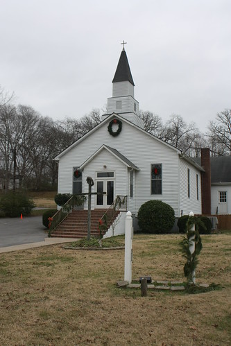
Our first stop was a walk around Billy's hometown of Kingston Springs, Tennessee. The small Cheatham county town along the Harpeth River has slowly become one of Nashville's more popular bedroom communities.
Kingston Springs' downtown is a mix of small cafes, restaurants, even a bar or two...
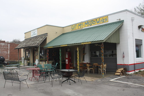
...with traditional Southern small town features.
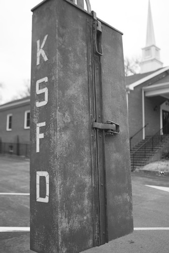
There are also some older items in town that caught my eye. Like this old fire call box - only a few blocks from the fire station.
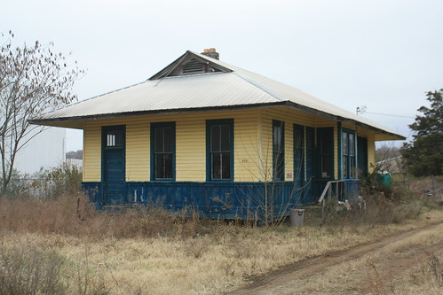
The former train depot in town sits perpendicular to the train tracks. I wonder if it had been moved. It appears that it has been in various stages of restoration and uses.
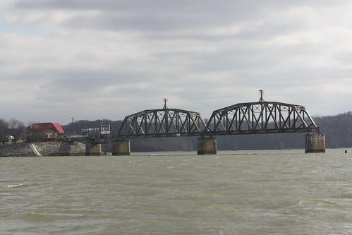
Just east of town is an abandoned truss bridge over the Harpeth River.
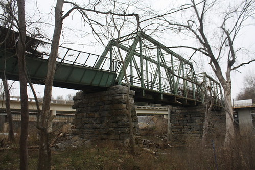
The bridge is in disrepair and is blocked off so no one can cross it.
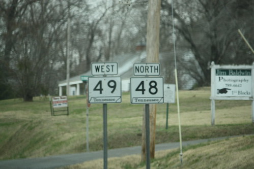
From there is was towards Charlotte - and a glimpse of a rare Tennessee signed multiplex of two state routes.
Then through Erin and Tennessee Ridge to the Houston-Benton ferry that carries TN 147 over the Tennessee River/Kentucky Lake.
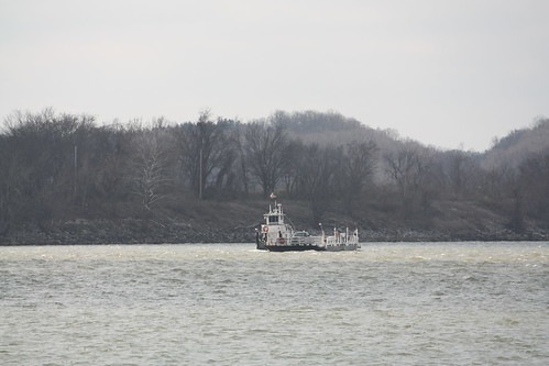
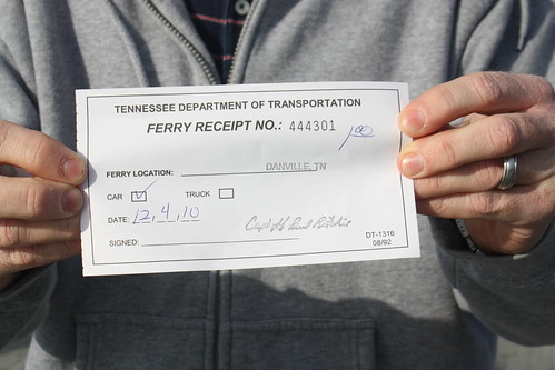
The ferry only costs $1, as Billy shows with his receipt below, and appears to have a fair volume of traffic.
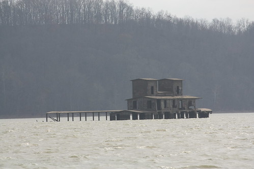
There is some character to the surroundings of the ferry. As an abandoned rail bridge...
..and what appears to be an abandoned warehouse or boat launch, sit south of the ferry landings.
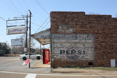
from there it was towards Paris and west to Dresden where we would pick up TN 22. Along the way, in the town of Como, we came across an old general store with a Pepsi ghost sign.
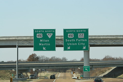
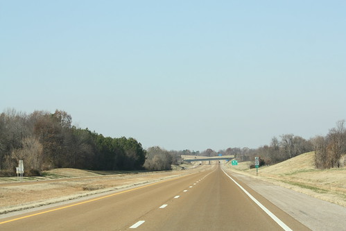
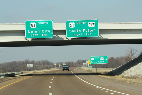
From Dresden we took TN 22 to Union City. TN 22 with a little help could possibly become Interstate 169. For now, it's just a nice interstate grade freeway from Union City to Martin.
Why TN 22 may have some trouble ever becoming I-169 is that the freeway ends with a diamond interchange with US 51. Also, Interstate 69 will run slightly north and west of where TN 22 meets US 51 today, so building an extension of the TN 22 freeway would have to be built as well.
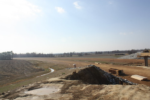
Speaking of Interstate 69, we did check out some of the I-69 construction north and west of Union City. Most of the photos taken were near the Goodyear Plant.
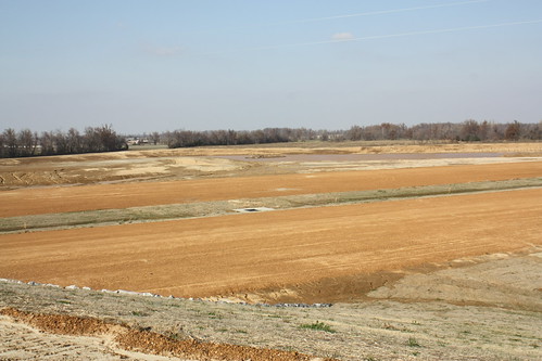
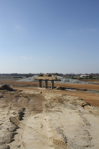
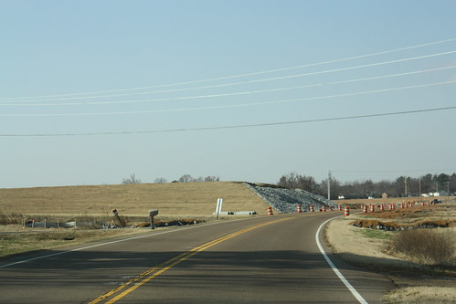
Some shots at what will be an interchange with TN 5.
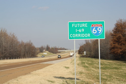
And outside of Union City - in this case on US 51 North headed towards Kentucky - there is a Future I-69 Corridor sign. They would be very common along the corridor route in both Tennessee and Kentucky.
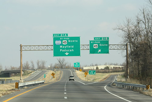
Once in Kentucky, we took the Purchase Parkway to Mayfield - where this interchange with US 45 will need an upgrade when I-69 rolls around.
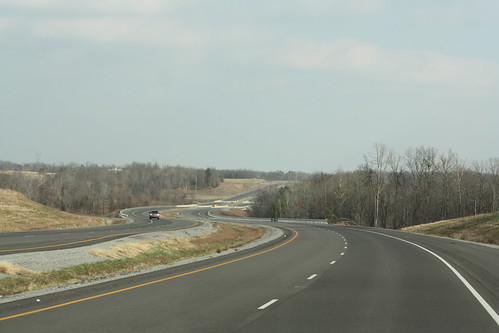
From Mayfield, we took the new four lane KY 80 east. Here's an example of what the new highway looks like.
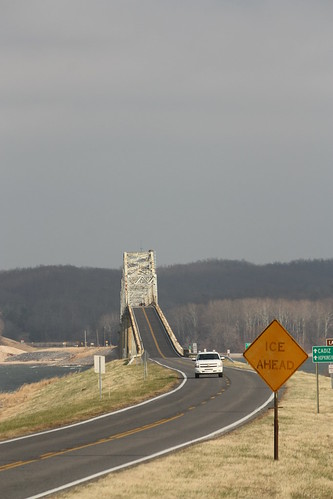
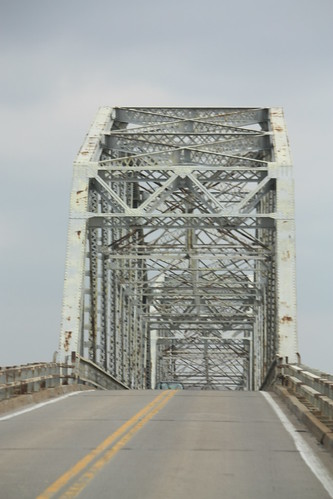
To get to Land Between the Lakes on US 68/KY 80, you have to cross great old truss bridges on either side. The first, for eastbound travelers, is this bridge over the Tennessee River.
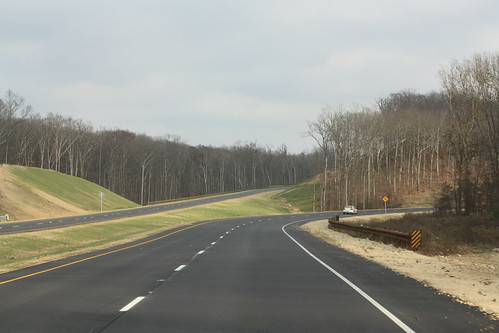
A recent widening project has made US 68/KY 80 to four lanes throughout the Land Between the Lakes. It is an easy and, even on a dreary, blustery, and bone chilling cold December afternoon, scenic drive.
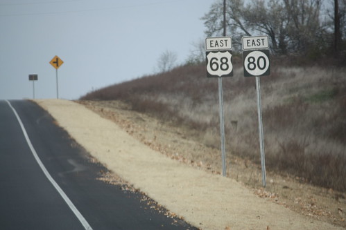
Though these Hellvetica US 68/KY 80 shields need to go.
..and exiting Land Between the Lakes on another old truss bridge, this time over Lake Barkley.
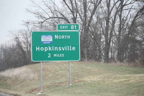
Now on I-24, we came to where the Pennyrile Parkway extension south from Hopkinsville meets I-24. Though the new road and interchange weren't open. The signs for the new exit (81) were installed and uncovered.
Now some in the hobby will be unhappy that the new sign is in clearview. I do have commentary on that, and you can read it here.
We took I-24 southeast into Nashville, where a blanket of grey flannel skies really took away from a spectacular approach and view of the city's skyline. (That and all of the trucks on I-24/65).
Billy, myself, and Seth Dunn then met up to watch the Nashville Predators defeat the Carolina Hurricanes 5-2. To see photos from that set, go here.
The loop route went as follows: US 70, TN 47, TN 49, TN 147, TN 69A, US 641, TN 54, TN 22, US 51, Purchase Parkway, US 45, KY 121, KY 80/(US 68) , and I-24 into Nashville.
For the entire flickr photo set - head here.
Our first stop was a walk around Billy's hometown of Kingston Springs, Tennessee. The small Cheatham county town along the Harpeth River has slowly become one of Nashville's more popular bedroom communities.
Kingston Springs' downtown is a mix of small cafes, restaurants, even a bar or two...
...with traditional Southern small town features.
There are also some older items in town that caught my eye. Like this old fire call box - only a few blocks from the fire station.
The former train depot in town sits perpendicular to the train tracks. I wonder if it had been moved. It appears that it has been in various stages of restoration and uses.
Just east of town is an abandoned truss bridge over the Harpeth River.
The bridge is in disrepair and is blocked off so no one can cross it.
From there is was towards Charlotte - and a glimpse of a rare Tennessee signed multiplex of two state routes.
Then through Erin and Tennessee Ridge to the Houston-Benton ferry that carries TN 147 over the Tennessee River/Kentucky Lake.
The ferry only costs $1, as Billy shows with his receipt below, and appears to have a fair volume of traffic.
There is some character to the surroundings of the ferry. As an abandoned rail bridge...
..and what appears to be an abandoned warehouse or boat launch, sit south of the ferry landings.
from there it was towards Paris and west to Dresden where we would pick up TN 22. Along the way, in the town of Como, we came across an old general store with a Pepsi ghost sign.
From Dresden we took TN 22 to Union City. TN 22 with a little help could possibly become Interstate 169. For now, it's just a nice interstate grade freeway from Union City to Martin.
Why TN 22 may have some trouble ever becoming I-169 is that the freeway ends with a diamond interchange with US 51. Also, Interstate 69 will run slightly north and west of where TN 22 meets US 51 today, so building an extension of the TN 22 freeway would have to be built as well.
Speaking of Interstate 69, we did check out some of the I-69 construction north and west of Union City. Most of the photos taken were near the Goodyear Plant.
Some shots at what will be an interchange with TN 5.
And outside of Union City - in this case on US 51 North headed towards Kentucky - there is a Future I-69 Corridor sign. They would be very common along the corridor route in both Tennessee and Kentucky.
Once in Kentucky, we took the Purchase Parkway to Mayfield - where this interchange with US 45 will need an upgrade when I-69 rolls around.
From Mayfield, we took the new four lane KY 80 east. Here's an example of what the new highway looks like.
To get to Land Between the Lakes on US 68/KY 80, you have to cross great old truss bridges on either side. The first, for eastbound travelers, is this bridge over the Tennessee River.
A recent widening project has made US 68/KY 80 to four lanes throughout the Land Between the Lakes. It is an easy and, even on a dreary, blustery, and bone chilling cold December afternoon, scenic drive.
Though these Hellvetica US 68/KY 80 shields need to go.
..and exiting Land Between the Lakes on another old truss bridge, this time over Lake Barkley.
Now on I-24, we came to where the Pennyrile Parkway extension south from Hopkinsville meets I-24. Though the new road and interchange weren't open. The signs for the new exit (81) were installed and uncovered.
Now some in the hobby will be unhappy that the new sign is in clearview. I do have commentary on that, and you can read it here.
We took I-24 southeast into Nashville, where a blanket of grey flannel skies really took away from a spectacular approach and view of the city's skyline. (That and all of the trucks on I-24/65).
Billy, myself, and Seth Dunn then met up to watch the Nashville Predators defeat the Carolina Hurricanes 5-2. To see photos from that set, go here.
Comments