
A skate at the Winter Classic Community Rink

 Maggie and I at the Winter Classic Community Rink

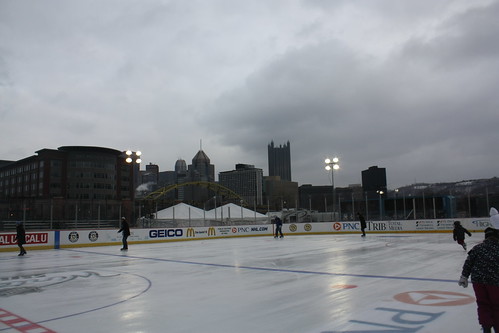
In what has become a Christmas tradition for Maggie and I, we've gone outdoor skating in Pittsburgh.  Last year, we skated at the public rink in PPG Plaza.  But this year was different, and on a Christmas Eve that is typical of a Pittsburgh winter gray, overcast, and just cold enough to support a fresh layer of snow in the morning, we had a memorable experience at the 2011 Winter Classic Community Rink.  The rink, which was constructed as part of the festivities for the 2011 Winter Classic between the Washington Capitals and Pittsburgh Penguins, is located just outside of Heinz Field.

In the time span of five days, the parking lot that sits between Stage AE and Heinz Field was transformed into a regulation ice rink where public skating, youth, high school, and college hockey games will take place.  Sure it's not a Rockfeller Center, but you really can't beat skating outside with an entire city skyline as a backdrop!

IMG_0449

If you follow this blog or know me, you know that I am a big hockey fan.  So being able to skate at the Winter Classic Community Rink was an amazing experience.  The Winter Classic has in four short years become hockey's Super Bowl, an event that captures the interest of the hardcore and the casual fan.  What started out as a novelty on January 1, 2008 in Buffalo has become a staple of the hockey calendar and New Year's Day.

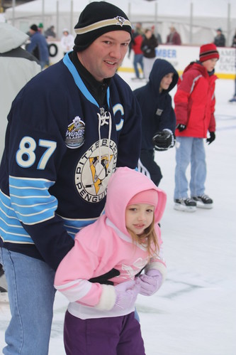
The goosebumps I felt while out on the ice and seeing and sharing the smiles and excitement of all that were on the ice that afternoon is something you don't see or get everyday.  Kids in their favorite Pittsburgh Penguin jerseys racing down the ice.  One child, who was a far superior skater than I, was making - or at least trying to - snow angels at center ice.  Fans and families who may not have tickets to the game taking photos on the rink as a souvenir from just being there.

IMG_0459

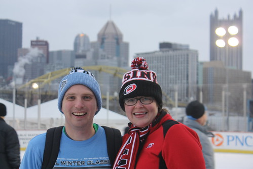
After spending some money on Winter Classic Memorabilia, which has been proudly added to our growing sports loft, we entered the rink when it opened to the public at 3 pm.  Maggie decked out head to toe in her Hurricanes gear attracted the attention of Pens fans and of the media.  We were both interviewed by KDKA-TV in Pittsburgh making the evening news.  We were also interviewed by Dan Rosen at NHL.Com.

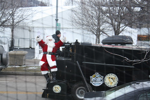
As for skating, things started out rough.  We were on rental skates, but once we sat down again and tightened the skates, there was no trouble at all!  The atmosphere was entirely festive as more and more people began to make it onto the ice.  Even Santa stopped by - arriving on a zamboni!

IMG_0503

As for the Winter Classic, I am extremely excited about the event.  Throw in that it's in Pittsburgh and it adds that much more.  The game has become a celebration of hockey and its fans.  In an age where most big sporting events are more oriented to the corporate sponsors.  The NHL Winter Classic truly celebrates the roots of a sport that not only the fans love and enjoy the players do as well.

My entire Winter Classic Community Set can be found on flickr.

Comments

Frank Brosnan said…
Adam, You might want to check this out about I-74 construction in OH

http://www.bizjournals.com/cincinnati/blog/2011/01/809m-tagged-to-extend-i-74-through.html

Popular posts from this blog

2018 Mojave Road Trip Part 2; The deadly desert highway (California State Route 127 and Nevada State Route 373)

After leaving Barstow via Old Highway 58 my next destination was in Death Valley.  To access Death Valley from rural San Bernardino County required a trek on north on Interstate 15 to California State Route 127 which becomes Nevada State Route 373 at the state line. Along I-15 I encountered the road sign oddity that is Zzyzx Road about eight miles south of Baker.   Zzyzx Road is a four mile road that used to go to the Zzyzx Mineral Springs and Health Spa.   The spa was founded in the 1940s and the owner made up the name "Zzyzx" to claim it was the last word in the English Language.  The spa has been shut down since the 1970s and is now part of a Desert Studies Center for California State University. The southern terminus of CA 127 in Baker is located at I-15 exit 246.  CA 127 is a 91 mile north/south highway which runs to the Nevada State Line in Inyo County.  CA 127 is called Death Valley Road from I-15 northward.  South of CA 127 ...

Finding the Pre-Emption Road of New York State

  The Pre-Emption Road (or rather a series of roads named Pre-Emption Road) follows a survey line called the Pre-Emption Line, drawn in the early days of the United States. The story begins with Massachusetts and New York having competing land claims to modern day Western New York State that have their roots in colonial charters granted by the British. After the Revolutionary War ended, this land became the frontier of the nation and its settlement became a priority for the new American government. During this era, there were a lot of competing land claims that needed to be settled. It was no different with the land claims between New York State and Massachusetts. On November 30, 1786, Massachusetts and New York sent representatives to Hartford, Connecticut to resolve their competing land claims. In less than three weeks, the representatives had reached a compromise. Massachusetts would receive pre-emption rights, meaning the right to sell the land after the Indian title ...

What's In a Name?: When the Roads Really Do Tell a Story

  Our tagline on the Gribblenation blog is "because every road tells a story". Some roads tell different stories than others. Along our travels, we may see historic markers that tell us a little story about the roads we travel or the places we pass by. Some historic markers are more general, as to telling us who lived where or what old trail traversed between two towns. During my travels across New York State and other states or provinces, I pass by many historic markers, some with interesting or amusing references to roads. I wanted to highlight a few of the markers I've seen along my travels around the Empire State and help tell their stories. Those stories may be as specific as explaining the tales of a tree that was used to help measure a distance of eight miles from Bath to Avoca in Steuben County, as referenced on the Eight Mile Tree historical marker above. They may also help point the way along historical roads first used centuries ago, or may help tell a local l...