
Some Texas sign finds

As from the prior post, I was in Houston last week.  I didn't get to take more than a half dozen photos, including the purple Westpark Tollway guide in the post below, but three of them are interesting (though not of the best quality).

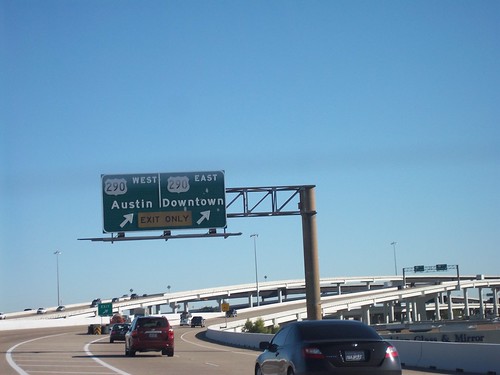
First, there are still a number of button copy guide signs on the Sam Houston Tollway - mainly at the larger interchanges (I-10 and US 290) for example.  And here is one older button copy overhead at US 290.

100_0053

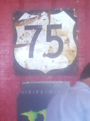
At lunch one afternoon, I found this older US 75 shield.  US 75 hasn't been in Houston since 1987.  Thank goodness for cell phone cameras!

You can still find US 75 in Houston

Finally, the biggest find - but the worst in quality - along one of the access roads at Bush Intercontinental Airport - I found this older Interstate 45 Texas shield.

100_0046

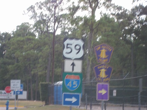
I didn't have the ability to get out of the car and take the photo, and on this trip I took a Kodak EasyShare point and shoot.  So sorry about the quality, but at least it was taken!

Comments

Popular posts from this blog

US Route 101 in Benbow, Garberville and Redway

The communities of Benbow, Garberville and Redway can all be found along US Route 101 within southern Humboldt County.  The former surface alignment of US Route 101 in Garberville and Redway once crossed the Garberville Bluffs along what is now Redwood Drive via a corridor constructed as part of the Redwood Highway during the 1910s.  US Route 101 through Benbow, Garberville and Redway was modernized by 1935.  US Route 101 would eventually be upgraded to freeway standards in Benbow, Garberville and Redway by extension of the Redwood Freeway during 1966-68.  As the cover photo the original grade of US Route 101 and the Redwood Highway can be seen at the Garberville Bluffs during 1934.  US Route 101 can be seen in the communities of Benbow, Garberville and Redway on the 1935 Division of Highways Map of Humboldt County .   The history of US Route 101 in Benbow, Garberville and Redway Benbow, Garberville and Redway lie on the banks of the South Fork Eel River of southern Humboldt County.  D

Highways in and around Old Sacramento; US 40, US 99W, CA 16, CA 24, CA 70, CA 99, CA 275, and more

This past weekend I was visiting the City of Sacramento for a wedding.  That being the case I decided to head out on a morning run through Old Sacramento, Jibboom Street Bridge, I Street Bridge, Tower Bridge, and path of US Route 40/US Route 99W towards the California State Capitol.  My goal was to retrace the paths of the various highways that once traversed the Old Sacramento area. This blog is part of the larger Gribblenation US Route 99 Page.  For more information pertaining to the other various segments of US Route 99 and it's three-digit child routes check out the link the below. Gribblenation US Route 99 Page The old highway alignments of Sacramento The City of Sacramento lies at the confluence of the Sacramento River and American River in Sacramento Valley.  Sacramento Valley was discovered by Spanish Explorer Gabriel Moraga in 1808.  Moraga referred to the fertile Sacramento Valley akin to a "Blessed Sacrament."  By 1839 John Sutter Sr. settled in Mexican held

Old Stage Road in Tulare County and Kern County

Old Stage Road is an approximately 30-mile rural highway comprised of Tulare County Mountain Road 1, Kern County Mountain Road 447 and Tulare County Mountain Road 109.  Old Stage originates at Jack Ranch Road near Posey and ends at the outskirts of Porterville at Deer Creek.  Old Stage Road notably is comprised of two 19th Century stage routes.  From White Mountain Road northwest to Fountain Springs, Old Stage Road overlays Thomas Baker's 1860s era stage road to Linn Valley (now Glennville) and the Kern River Gold Rush Claims.  From Fountain Springs to Deer Creek, Old Stage Road is comprised of the 1853 Stockton-Los Angeles Road. Featured as the blog cover is the northward descent on Old Stage Road along Arrastre Creek to the town site of White River.  What became White River was settled along a spur of the Stockton-Los Angeles Road as "Dog Town" when gold was discovered nearby.  By 1856 the community had been renamed Tailholt.  A stage road from Tailholt to Linn Valley w