
Maggie and I both like to hike and this trip to Pennsylvania was no different. I took Maggie to another favorite Western Pennsylvania destination of mine, McConnell's Mill State Park. McConnell's Mill is about 40 miles north of Pittsburgh. With numerous choices for outdoor activities (hiking, rock climbing, fishing, and whitewater rafting), McConnell's Mill is a popular day trip for many Pittsburghers and photographers.
Here's our photoset from our trip over at flickr.
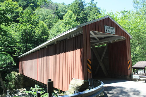
The centerpiece of the park is a over 130 year old grist mill and covered bridge.

The rolling mill still has operating parts and inside the mill are three floors worth of exhibits. The covered bridge first crossed Slippery Rock Creek in 1874 and was recently rehabilitated in 1998.
Rock Climbing isn't our specialty, and I have thrown a fishing line in over a decade; but we do enjoy outdoor hiking. There are nine miles of trails within the park varying from a half mile easy hike to a rugged 6.2 mile Slippery Rock Gorge Trail.
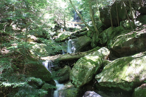
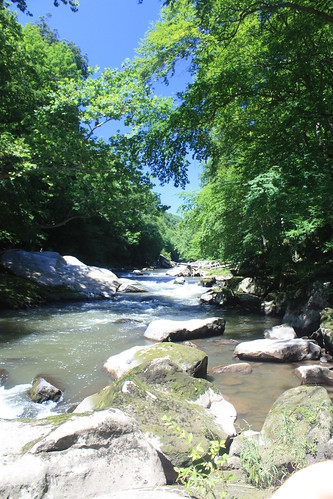
Our first hike was the two mile Kildoo Trail. This trail runs as a two mile loop from the covered bridge downstream along Slippery Rock Creek. The trail crosses the Eckert Bridge and returns upstream to the covered bridge and mill. The hike offers numerous views of small waterfalls and of the swift flowing Slippery Rock Creek. At a number of points, you are able to walk out on giant boulders to get a closer look at the stream and relax in the sun. Although the eastern side of the trail is not marked, it is not that difficult to follow. The western side of the trail is marked with blue blazes as it is part of the North Country National Scenic Trail.
Though the published length of the Kildoo Trail is two miles roundtrip. It does seem longer. I would suggest that the park add blazes to the eastern side of the trail, as a number of other hikers we met noted the lack of blazes.
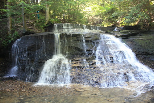
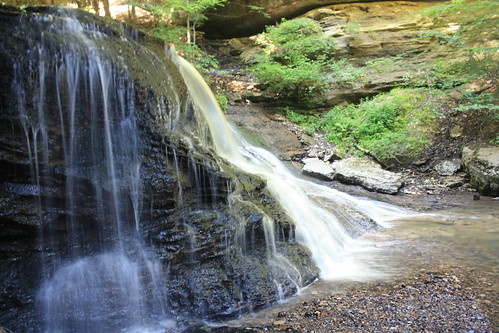
Our next hike was to Hells Hollow along the aptly named Hells Hollow Trail. This flat 1/2 mile hike leads to a beautiful waterfall.
If you don't want to hike the additional six miles to get to the falls from the Eckert Bridge, park maps give directions to the falls from the covered bridge. Keep the map handy as you will need a keen eye to follow the wayfinding markers to the falls.
There's one more treat on the way out of the park. A 1940 truss bridge that carries Mountville Road over a calmer Slippery Rock Creek offers great views and judging from the cars around - great fishing, too.

McConnell's Mill State Park is a great place to visit, and it will be a special place for us. As underneath the falls, I proposed to Maggie. And of course she said, Yes!
One last part of the trip to share and it's a road trip in rural Washington County.
Here's our photoset from our trip over at flickr.
The centerpiece of the park is a over 130 year old grist mill and covered bridge.
The rolling mill still has operating parts and inside the mill are three floors worth of exhibits. The covered bridge first crossed Slippery Rock Creek in 1874 and was recently rehabilitated in 1998.
Rock Climbing isn't our specialty, and I have thrown a fishing line in over a decade; but we do enjoy outdoor hiking. There are nine miles of trails within the park varying from a half mile easy hike to a rugged 6.2 mile Slippery Rock Gorge Trail.
Our first hike was the two mile Kildoo Trail. This trail runs as a two mile loop from the covered bridge downstream along Slippery Rock Creek. The trail crosses the Eckert Bridge and returns upstream to the covered bridge and mill. The hike offers numerous views of small waterfalls and of the swift flowing Slippery Rock Creek. At a number of points, you are able to walk out on giant boulders to get a closer look at the stream and relax in the sun. Although the eastern side of the trail is not marked, it is not that difficult to follow. The western side of the trail is marked with blue blazes as it is part of the North Country National Scenic Trail.
Though the published length of the Kildoo Trail is two miles roundtrip. It does seem longer. I would suggest that the park add blazes to the eastern side of the trail, as a number of other hikers we met noted the lack of blazes.
Our next hike was to Hells Hollow along the aptly named Hells Hollow Trail. This flat 1/2 mile hike leads to a beautiful waterfall.
If you don't want to hike the additional six miles to get to the falls from the Eckert Bridge, park maps give directions to the falls from the covered bridge. Keep the map handy as you will need a keen eye to follow the wayfinding markers to the falls.
There's one more treat on the way out of the park. A 1940 truss bridge that carries Mountville Road over a calmer Slippery Rock Creek offers great views and judging from the cars around - great fishing, too.
McConnell's Mill State Park is a great place to visit, and it will be a special place for us. As underneath the falls, I proposed to Maggie. And of course she said, Yes!
One last part of the trip to share and it's a road trip in rural Washington County.
Comments