
California State Route 1


California State Route 1 ranks amongst the most scenic highways in the world and is frequently featured on Gribblenation.  As currently configured California State Route 1 follows a largely coastal alignment between San Juan Capistrano to Leggett.  California State Route 1 contains notable segments such as the Pacific Coast Highway through Malibu, Rincon Causeway, Cabrillo Highway through Big Sur, the San Francisco Peninsula, the Golden Gate Bridge and North Shore Highway.  Below is a compellation of all Gribblenation blog materials on California State Route 1 along with a brief history of major events along the classic scenic highway.  


California State Route 1 blog directory


Notable events in the history of California State Route 1

The origin of what is now California State Route 1 can be found with the creation of Legislative Route Number 56 (LRN 56) as part of the 1919 Third State Highway Bond Act.  LRN 56 was originally defined simply as a highway aligned from Carmel to San Simeon.  LRN 56 would be extended from San Simeon to Cambria by way of 1921 Legislative Chapter 837.  

The dedication ceremony for the opening the Bixby Creek Bridge was held on November 28, 1932 and was featured in the December 1932 California Highways and Public Works.  The Bixby Creek Bridge to most is the signature structure of California State Route 1 within the Big Sur region and is a direct replacement for what is known as the Coast Road. 


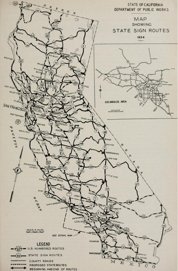
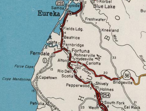
In 1933 the definition of LRN 56 was extended south to LRN 2 (US Route 101) near Las Cruces and north to Ferndale to LRN 1 (also US Route 101) through the Lost Coast region.  The August 1934 California Highways and Public Works featured the initial run of Sign State Routes.  California State Route 1 was applied to LRN 56 from Las Cruces northward towards Fortuna


The Ocotber 1934 California Highways and Public Works cites the very first Sign State Route Shield was installed as part of California State Route 1 in Carmel.  The first Sign Route shield was installed on September 10, 1934, at the junction of the Carmel, Pacific Grove, and Monterey Highways.  


The Golden Gate Bridge was completed April 19, 1937 and was ultimately dedicated on May 28.  The ceremonies leading up to the opening of the Golden Gate Bridge are discussed in the May 1937 California Highways & Public Works.  The article notes the unlike the State built San Francisco-Oakland Bay Bridge construction of the Golden Gate Bridge was financed by the six Counties of San Francisco Bay.  Thusly even from the outset the Golden Gate Bridge was never considered to be a State Highway facility.  The Golden Gate Bridge features an 8,980-foot-long hybrid truss-suspension design.  The Golden Gate Bridge from the outset carried the implied routing of US Route 101 and California State Route 1 despite not being a state-maintained structure.  


On June 27, 1937, California State Route 1 opened entirely through Big Sur and as the Carmel-San Simeon Highway.  The surface of CA 1 in Big Sur when it opened was oiled earth aside from the segment north of the community of Big Sur.  The opening of the Carmel-San Simeon Highway through Big Sur is the cover story of the July 1937 California Highway and Public Works Guide.


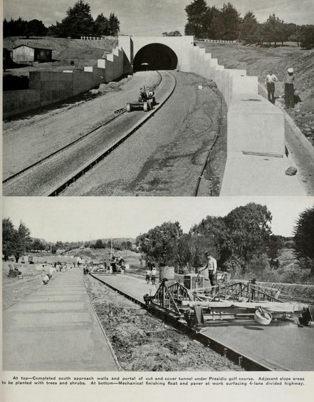
The March 1940 California Highways & Public Works shows the Park-Presidio Boulevard/Funston Avenue Approach of California State Route 1 in ongoing construction.  The article cites the Park-Presidio Boulevard Funston Avenue Approach as having an anticipated completion date of April 15.  The 1,300-foot-long tunnel under the Presidio Golf Course is cited as having been completed in January of 1940.  Following the opening of Park-Presidio Boulevard the alignment of California State Route 1in San Francisco was complete  


The May/June 1957 California Highways & Public Works announced California State Route 1 between Valley Ford and Jenner via Bodega Bay was about to finally become part of LRN 56 on July 1.  California State Route 1 between Valley Ford and Jenner was upgraded via Federal Aid Secondary County Route 777 (FAS 777).  FAS 777 had been under construction since September of 1951 and included a brand new 8.9-mile road directly linking Valley Ford to Bodega Bay.  The inclusion of road between Valley Ford and Jenner closed a gap in State maintenance of California State Route 1. 


A story regarding the new Westport-Leggett Spur of LRN 56 is detailed in the May/June 1958 California Highways & Public Works.  The Westport-Leggett spur of LRN 56 was indeed ultimately signed as part of California State Route 1 and was part of FAS Route 504.  Mendocino County is said to have pushed during the fall of 1955 to have the planned Westport-Leggett Spur of LRN 56 added Federal Aid Secondary system.  The article goes onto cite that part of the 1951 legislation that added the Westport-Leggett Spur of LRN 56 was that the State would not have to maintain the roadway until it was brought up to Division of Highways standards.  Maintenance of the Westport-Leggett Spur of LRN 56 began on July 1, 1957.


During the 1964 State Highway Renumbering the Legislative Route Numbers were dropped.  What had been the spur of LRN 56 to Leggett was renumbered to California State Route 208.  California State Route 1 remained planned through the Lost Coast to Ferndale.  These changes can be seen on the 1964 Division of Highways State Map.


1964 State Highway Renumbering also extended California State Route 1 from Las Cruces southward through Santa Barbara Channel on a silent multiplex of US Route 101 to what was US Route 101 Alternate/LRN 60 in Oxnard.  California State Route 1 was further extended to a new southern terminus on what had been US Route 101 Alternate to San Juan Capistrano.  The new multiplex of California State 1 on US 101 from Las Cruces to Oxnard and new terminus in San Juan Capistrano first appears on the 1964 Division of Highways State Map


The cover of the March/April 1964 California Highways & Public Works features a US Route 101 Alternate shield near Point Magu being replaced with California State Route 1.  

California State Route 1was spun off onto its own alignment away from US Route 101 on the Rincon Seawall as part of 1980 Legislative Chapter 740.  This new standalone segment of California State Route 1 on the Rincon Seawall was created after US Route 101 had been moved uphill above the Union Pacific Railroad onto a freeway grade.  

During 1984 the unbuilt California State Route 1 in the Lost Coast and from Ferndale to Fortuna was transferred California State Route 211 via Legislative Chapter 489.  Legislative Chapter 489 also transferred California State Route 1 over what had been California State Route 208.  The changes described above first appear on the 1986 Caltrans State Highway Map.


Comments

Popular posts from this blog

Paper Highways: The Unbuilt New Orleans Bypass (Proposed I-410)

  There are many examples around the United States of proposed freeway corridors in urban areas that never saw the light of day for one reason or another. They all fall somewhere in between the little-known and the infamous and from the mundane to the spectacular. One of the more obscure and interesting examples of such a project is the short-lived idea to construct a southern beltway for the New Orleans metropolitan area in the 1960s and 70s. Greater New Orleans and its surrounding area grew rapidly in the years after World War II, as suburban sprawl encroached on the historically rural downriver parishes around the city. In response to the development of the region’s Westbank and the emergence of communities in St. Charles and St. John the Baptist Parishes as viable suburban communities during this period, regional planners began to consider concepts for new infrastructure projects to serve this growing population.  The idea for a circular freeway around the southern perimeter of t

Hernando de Soto Bridge (Memphis, TN)

The newest of the bridges that span the lower Mississippi River at Memphis, the Hernando de Soto Bridge was completed in 1973 and carries Interstate 40 between downtown Memphis and West Memphis, AR. The bridge’s signature M-shaped superstructure makes it an instantly recognizable landmark in the city and one of the most visually unique bridges on the Mississippi River. As early as 1953, Memphis city planners recommended the construction of a second highway bridge across the Mississippi River to connect the city with West Memphis, AR. The Memphis & Arkansas Bridge had been completed only four years earlier a couple miles downriver from downtown, however it was expected that long-term growth in the metro area would warrant the construction of an additional bridge, the fourth crossing of the Mississippi River to be built at Memphis, in the not-too-distant future. Unlike the previous three Mississippi River bridges to be built the city, the location chosen for this bridge was about two

Huey P. Long Bridge (New Orleans, LA)

Located on the lower Mississippi River a few miles west of New Orleans, the Huey P. Long Bridge is an enormous steel truss bridge that carries both road and rail traffic on an old-time structure that is a fascinating example of a bridge that has evolved in recent years to meet the traffic and safety demands of modern times. While officially located in suburban Jefferson Parish near the unincorporated community of Bridge City, this bridge’s location is most often associated with New Orleans, given that it’s the largest and most recognizable incorporated population center in the nearby vicinity. For this reason, this blog article considers the bridge’s location to be in New Orleans, even though this isn’t 100% geographically correct. Completed in 1935 as the first bridge across the Mississippi River in Louisiana and the first to be built in the New Orleans area, this bridge is one of two bridges on the Mississippi named for Huey P. Long, a Louisiana politician who served as the 40th Gove