The Fernbridge near the city of Ferndale in Humboldt County was completed during 1911 over the Eel River and presently a component of California State Route 211. Upon opening, the Fernbridge was then the longest concrete arch bridge in the world. The Fernbridge is often touted as the precursor span which inspired similar arch concrete bridge designs which were constructed during the early twentieth century in California. The Fernbridge stood against flooding on the Eel River during 1912, 1913, 1914, 1915, 1937, 1953, 1955, 1964, and 1986. During 1987 Caltrans recommended replacing the Fernbridge with a modern span which sparked a local movement to preserve the structure. The Fernbridge has also withstood numerous earthquakes including the 1992 Cape Mendocino Earthquakes and the Ferndale Earthquake of December 2022. The cover photo of this blog is the Fernbridge as depicted in the September 1950 California Highways & Public Works Centennial edition.
Part 1; the history of the Fernbridge
The Fernbridge serves as the primary connection between Ferndale and Eureka via the Eel River. Ferndale was established during 1852 and quickly grew in importance along the isolated North Coast of California. Ferndale incorporated as a City during August of 1893 and boasts a present population of approximately 1,400 residents.
The May/June 1964 California Highways & Public Works referenced the early history of the highway between Ferndale and Eureka. During July 1865 the Eel River & Mattole Plank Turnpike Company was formed with the goal of constructing a stage road from Petrolia north to Eureka via Ferndale and Table Bluff. Construction of the highway between Petrolia-Eureka began during 1869 and was completed by 1871. According to visitferndale.com the stage route north of Ferndale was connected to Eureka via the Eel River crossings of Singley's Ferry, Robinson's Ferry and East's Ferry. When the Eel River was low during the midst of dry periods temporary low water bridges would be set up for stages to cross.


Singley's Ferry and Robinson's Ferry can be seen connecting Ferndale and Eureka on the 1882 Bancroft's Map of California. East's Ferry is not displayed but connected what is now Ferry Road to Drake Hill Road. The stage route over Singley's Ferry can be seen directly connecting Ferndale to Eureka via Table Bluff.
Approaching the end of the 19th century residents of Ferndale and greater Eel River Valley began to petition for a bridge to be constructed at the Eel River. According to co.humboldt.ca.us, a community petition was submitted to the Humboldt County Board of Supervisors on
January 12, 1893, asking for a permanent bridge to be constructed at the Eel River.
The destruction brough by the 1906 San Francisco Earthquake necessitated any bridge located at the Eel River to be constructed of reinforced concrete. Another petition to construct a bridge over the Eel River was submitted by Ferndale residents on February 10, 1909. On November 8, 1909, the Humboldt County Surveyor submitted a report suggesting the location of Singley's Bend as a recommended site for an Eel River Bridge. Humboldt County accepted bids by Pacific Construction to build the Fernbridge during 1910 and construction broke ground on March 20th at Singley's Bend. The concrete arch construction of the Fernbridge was designed by engineer John B. Leonard.


The Fernbridge was completed on November 8, 1911 and opened to traffic on November 16th. The Fernbridge (referred to in-article as the Eel River Bridge) was featured in the
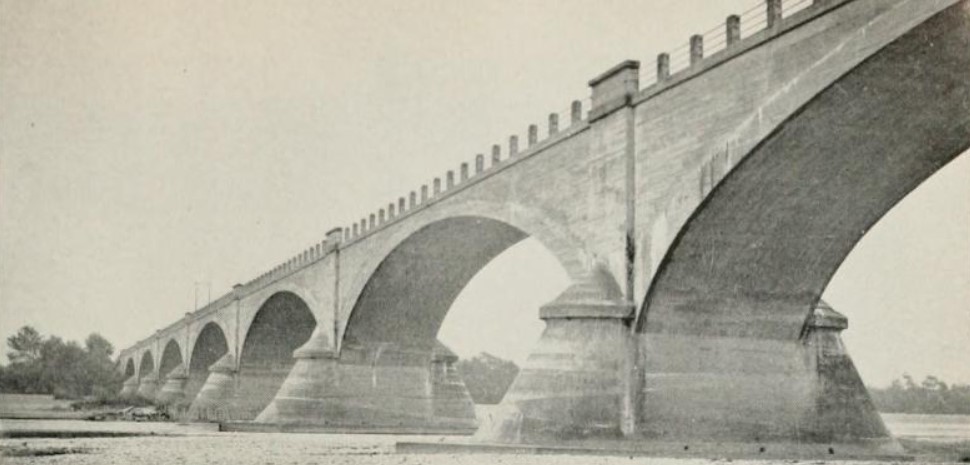
November 21, 1911 San Francisco Call. The Fernbridge was noted to carry a total distance of 2,501 feet and was at the time the longest arch concrete span in the world. The central arch concrete structure of the Fernbridge is noted to be 1,451 feet with the balance of the structure's remaining length being comprised of wooden approach spans. The Fernbridge road deck for the time was a then wide 24 feet. Construction of the Fernbridge is noted to have cost $245,967.
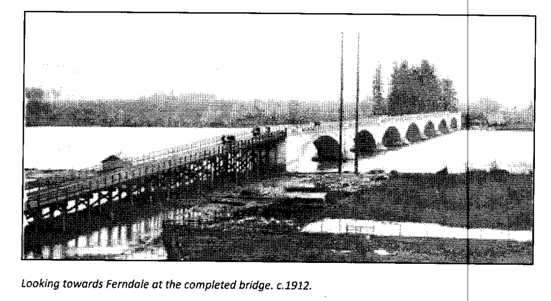
The Fernbridge with it's original wooden approaches can be seen in a Humboldt County sourced photo circa
1912.
The Fernbridge was subjected to flooding along the Eel River during 1912, 1913, 1914 and 1915. During 1920 the wooden approach spans to the Fernbridge were replaced with concrete ramps. During 1933
Legislative Route Number 56 was extended south to Legislative Route Number 2 (US Route 101) near Las Cruces and north to Fortuna to Legislative Route Number 1 (also US Route 101) via the Fernbridge. Prior to 1933 the legislative description of Legislative Route Number 56 had it's north terminus in Carmel and south terminus in San Luis Obispo. The extension of LRN 56 was ambitious and was the first time that the State became involved with a coastal highway in the Lost Coast region.
The August 1934 California Highways and Public Works announced the first run of Sign State Routes. California State Route 1 was applied to Legislative Route Number 56 from Las Cruces northward towards Fortuna via the Fernbirdge.
The Fernbridge can be seen as part of California State Route 1 and Legislative Route Number 56 on the
1935 Division of Highways Map of Humboldt County.
The
January 1938 California Highways & Public Works referenced the Fernbridge as being inundated during the December 1937 floods of Northern California. The flooding around the Fernbridge is depicted in Item 3 of the December 1937 flood photos.
The Fernbridge was featured in the
September 1950 California Highways & Public Works Centennial edition. The Fernbridge is noted for carrying a groundbreaking arch concrete design which was later emulated in the 1913 Arroyo Seco Bridge, 1914 Cabrillo Bridge and numerous State Highway bridges of the 1st, 2nd and 3rd State Highway Bond Acts.
The Fernbridge would be subjected to flooding during 1953. The
January/February 1956 California Highways & Public Works featured the flooding damage in Northern California during the 1955 Christmas Week Floods. The concrete western approach to the Fernbridge is noted to have been bent by flooding on the Eel River in a Division of Highways District I recap.
The
September/October 1961 California Highways & Public Works announced the California Highway Commision had selected a freeway routing for California State Route 1/Legislative Route Number 56 from Van Ness Avenue in Ferndale to the western approach to the Fernbridge during the summer California Commission Meetings. This corridor was ultimately constructed as a two-lane expressway which terminated at the western approach of the Fernbridge in the following years.

The
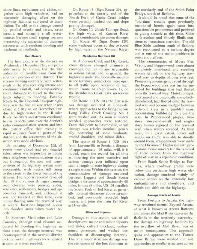
May/April 1965 California Highways & Public Works featured the damage to the Redwood Highway corridor during the Christmas Floods of December 1964. The Fernbridge notably was one of the only structures along the Eel River to have survived the 1964 Christmas Floods with minimal damage. For a time, the Fernbridge in conjunction with Blue Slide Road was pressed into duty as the temporary alignment of US Route 101. A Division of Highways District I photo depicts the cleanup efforts at the Fernbridge after the 1964 Christmas Floods.
On September 24, 1976, the American Society of Engineering designated the Fernbridge as a significant civil engineering landmark. Below a photo (
by Nytasi) of the American Society of Engineering plaque affixed to the Fernbridge can be seen.

During 1984 the unbuilt portion of California State Route 1 in the Lost Coast and from Ferndale to Fortuna was transferred to the second iteration of California State Route 211 via
Legislative Chapter 489. This measure made the Fernbridge part of California State Route 211. Legislative Chapter 489 also transferred California State Route 1 over what had been California State Route 208. The changes first appear on the
1986 Caltrans State Highway Map.
A 75th Anniversary celebration was held on the Fernbridge on November 16, 1986. 2,500 are noted to have attended the 75th Anniversary of the Fernbridge. Then President Ronald Reagan sent a note of greetings to the residents of Eel River Valley as they celebrated the 75th Anniversary of Humboldt County's "Queen of Bridges." 1986 coincidentally the last year major flooding occurred along the Eel River at the Fernbridge.
Following the floods of 1986 Caltrans District I recommended conducting a study to remove the Fernbridge in favor of a modern span. During February 1987 the State Office of Historic Preservation approved the Fernbridge as being eligible for the National Register of Historic Places. Eel River Valley community resistance towards the removal or replacement of the Fernbridge was featured in the
March 13, 1987, Los Angeles Times. By April 1987, the Fernbridge was added to the National Register of Historic Places.
Caltrans would ultimately opt not to remove the Fernbridge after it was added to the National Register of Historic Places. During August 1990 the Fernbridge was given a Poor Sufficiency rating of 10.8.
On April 25-26, 1992, the
Cape Mendocino Earthquakes shook the North Coast and Eel River Valley regions. The first 7.2 magnitude earthquake occurred at 11:06 AM on April 25th and was centered three miles east of Petrolia. Two 6.5 magnitude aftershocks occurred on April 26th and centered west of Petrolia. Despite the nearby shaking and Poor Sufficiency rating of the Fernbridge the structure survived. In the years after the Cape Mendocino Earthquakes the Fernbridge was renovated. During 1998 the Fernbridge received a
Sufficiency Rating of 33.0.
On December 20, 2022, the 6.4 magnitude Ferndale Earthquake structure just offshore west of Ferndale at 2:34 AM. The Ferndale Earthquake as of the publishing date of this blog has had 2 attributable fatalities and 17 injuries. Approximately 150 structures largely centered around Rio Dell were damaged or destroyed by the Ferndale Earthquake.
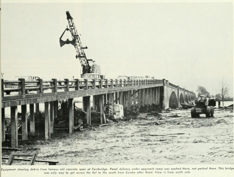
On December 20, 2022, the
Caltrans District I Facebook account reported damage to the Fernbridge resulting from the Ferndale Earthquake. Caltrans District I closed the Fernbridge to conduct assessments to structure due to apparent seismic damage to the approach western approach span. Photos from Caltrans District I depict the damage to the western approach of the Fernbridge.
On December 21, 2022, the
Caltrans District I Facebook Account announced the reopening of the Fernbridge to one-way traffic at 7:30 PM. The Caltrans District I photo below depicts the first cars crossing the Fernbridge upon reopening.
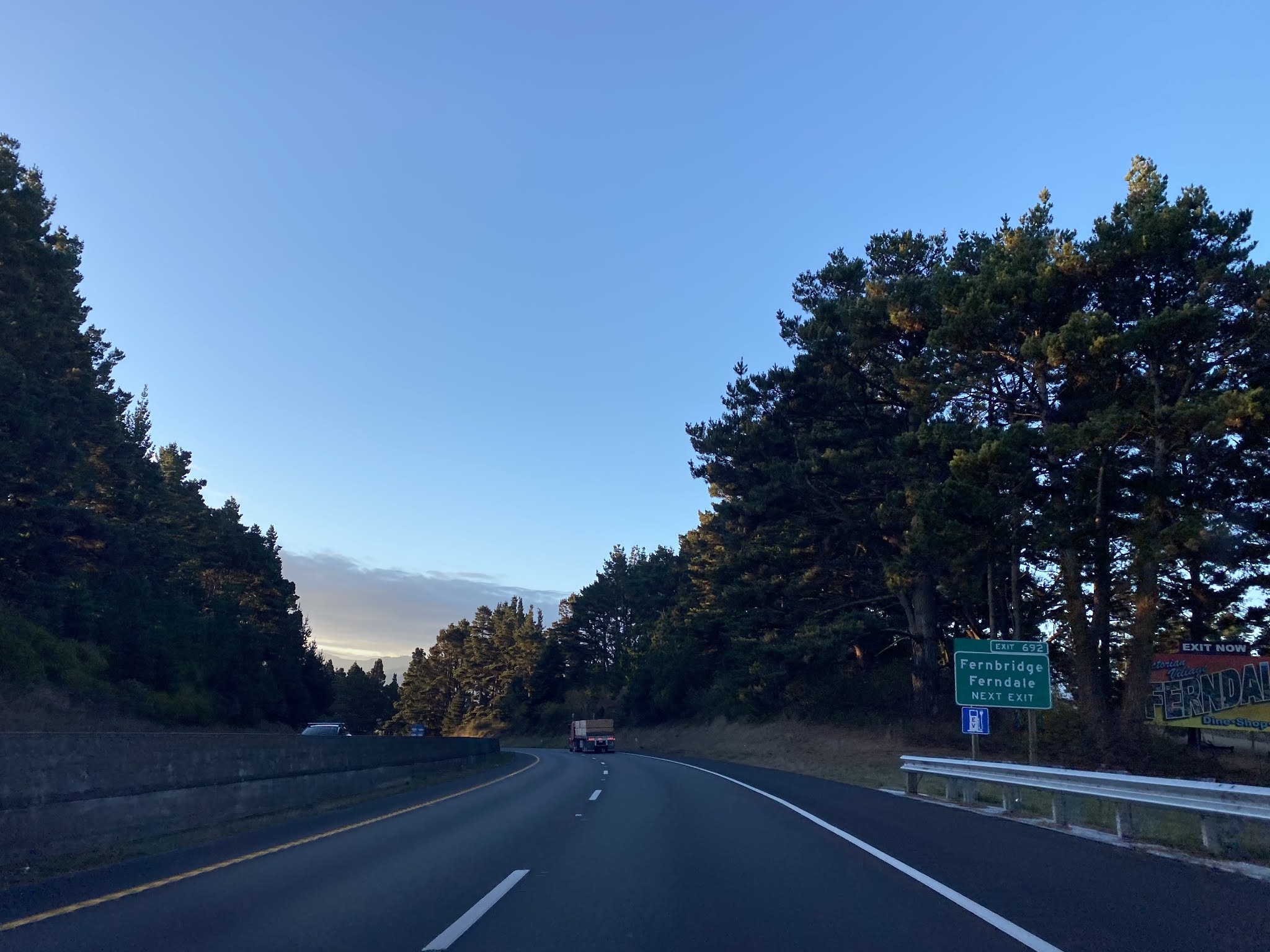
Part 2; a drive on the FernbridgeFrom US Route 101 southbound, California State Route 211 can be accessed at Exit 692. From Exit 692 there are no California State Route 211 reassurance shields.
California State Route 211 from US Route 101 is signed as 5 miles from Ferndale.
California State Route 211 south enters the community of Fernbridge at Post Mile HUM 78.586.
California State Route 211 south makes a right hand turn in Fernbridge towards the Eel River and Ferndale.
The Northwestern Pacific Railroad Depot can be found off of California State Route 211 next to the Fernbridge. The community of Fernbridge was originally known as Singley's Station in reference to George Singley's Ferry when it plotted during 1885. The community of Singley Station began to go by the name of "Fernbridge" shortly after the span over the Eel River opened. The United States Postal Service formally changed the name of Singley's Station to Fernbridge during 1924.
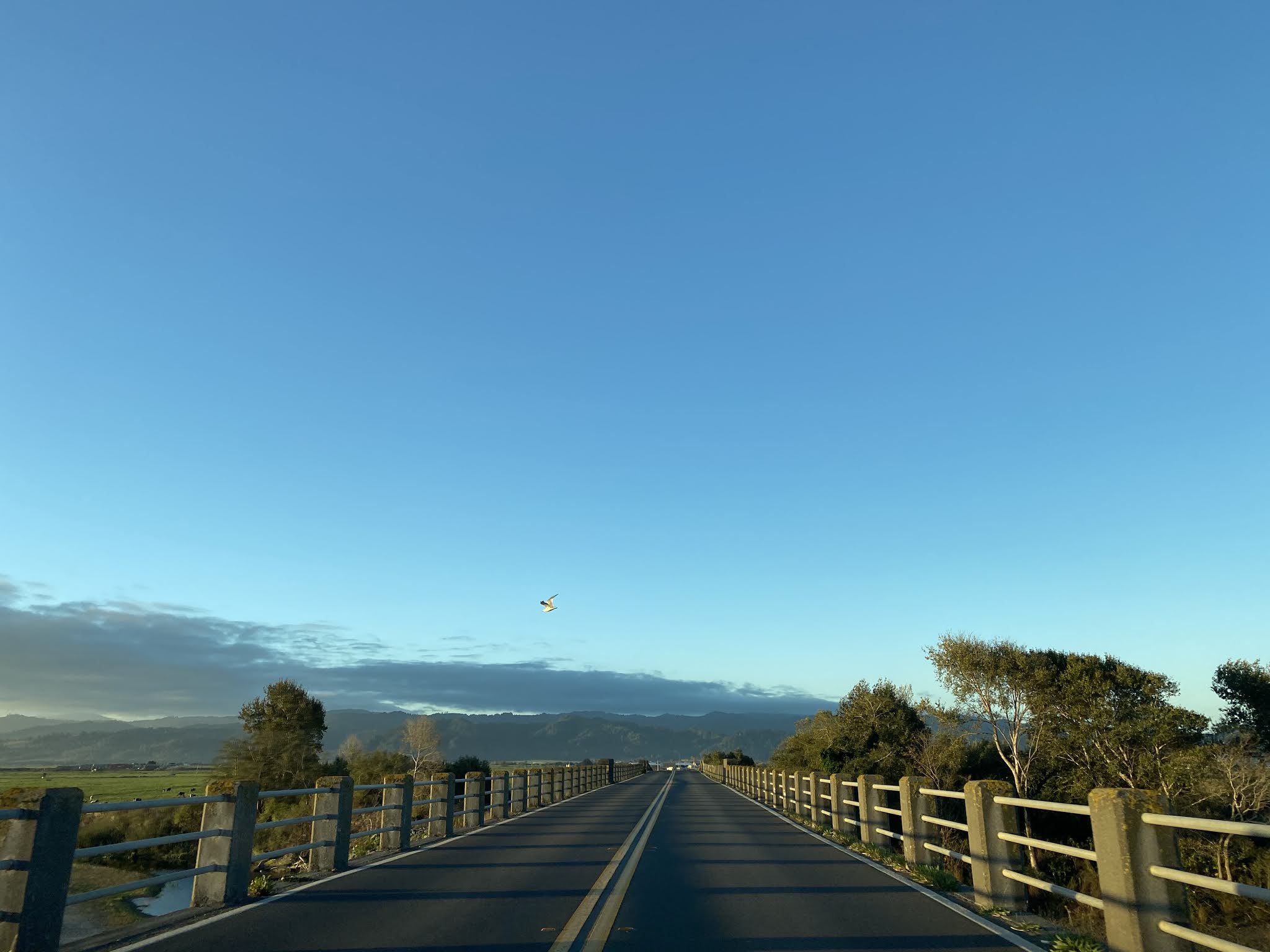
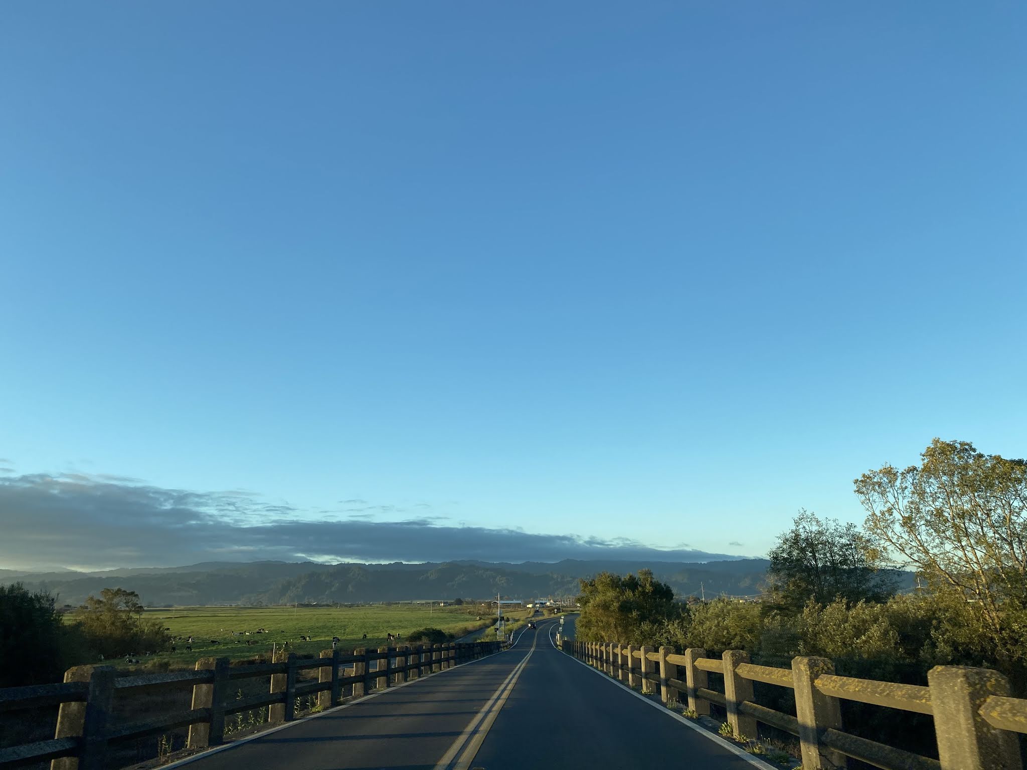
California State Route 211 southbound crosses the railroad tracks and begins to cross the Fernbridge over the Eel River. The Fernbridge is adorned with advisory signs altering traffic to watch for tractors and bicycles.


Comments