Kingston, NY's New Roundabout Intersection Gets High Marks from Travelers


In what turned out to be a $12 million investment from the New York State Department of Transportation and the City of Kingston, NY, the four-way intersection connecting Broadway, Albany Avenue, and Interstate 587 was transformed into a much more efficient transfer point for traffic traversing western Kingston in all directions. The original four-way intersection here dated to the 1950s and its traffic signals were notoriously inefficient. Additionally, safe passage for pedestrians and other non-motorized traffic was no guarantee as those movements were not safely accounted for in the original design.
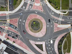

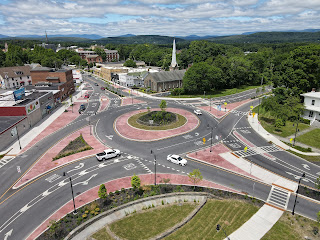
Above: The new Albany Avenue/Broadway Roundabout project increases efficiency of traffic movements across west Kingston while also improving motorist & pedestrian safety at one of the city's busiest intersections.

Construction of this $12 million project began in early 2020 and persevered throughout the COVID-19 Pandemic. Substantial completion status was attained at the end of 2021, with physical completion status being reached in Spring 2022. The new-look intersection has already had a significant impact on  travelers of all methods and has been a much needed investment for what had previously been one of Kingston's most outdated traffic transfer points.

The following pictures were taken by the author of this post using a DJI quadcopter drone. Always use proper judgment and situational awareness when flying in areas such as this. Click on each photo to see a larger version.


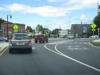
The following pictures were taken by the author of this post and detail some of the new traffic patterns and signage now in place at the new intersection:


Comments

Stephen Taylor said…
In Texas they're called traffic circles, and they're making a comeback. Austin is beginning to use them all over the city, including at a troublesome intersection near our home. The intersection has a large amount of north/south traffic, a steady amount of east traffic and very little from the west. Nasty intersection, controlled only by four stop signs. The COA installed the new traffic circle, and the intersection is now a joy to navigate. The traffic backups from the north continue, but traffic continues to flow and the backups move very quickly. The circle is very small, but it works very, very well. A good use of taxpayer money. Austin is also placing small circles in neighborhoods around town. My wife, who moved to Texas from Chicago, had never seen one and had to be taught how to use them. )She also had to be taught about low-water crossings and flash floods, but that's another story.)

My hometown had a large one where one east/west highway forked to the southwest and the northwest. TxDot installed a circle there back in the '50. Kids growing up in that town learned to navigate "The Circle" as it was called, very early on. It worked very well for my hometown, but when traffic circles fell out of favor with TxDot, the circle was replaced by a very awkwardly designed intersection with traffic signals. The locals hate that intersection with the white-hot heat of a thousand burning suns and wish they had their old circle back. They were all over Southeast Texas, and even today, in places where the circles have been replaced, businesses will still advertise their location as being "on the circle".

Popular posts from this blog

Old River Lock & Control Structure (Lettsworth, LA)

  The Old River Control Structure (ORCS) and its connecting satellite facilities combine to form one of the most impressive flood control complexes in North America. Located along the west bank of the Mississippi River near the confluence with the Red River and Atchafalaya River nearby, this structure system was fundamentally made possible by the Flood Control Act of 1928 that was passed by the United States Congress in the aftermath of the Great Mississippi River Flood of 1927 however a second, less obvious motivation influenced the construction here. The Mississippi River’s channel has gradually elongated and meandered in the area over the centuries, creating new oxbows and sandbars that made navigation of the river challenging and time-consuming through the steamboat era of the 1800s. This treacherous area of the river known as “Turnbull’s Bend” was where the mouth of the Red River was located that the upriver end of the bend and the Atchafalaya River, then effectively an outflow

Memphis & Arkansas Bridge (Memphis, TN)

  Like the expansion of the railroads the previous century, the modernization of the country’s highway infrastructure in the early and mid 20th Century required the construction of new landmark bridges along the lower Mississippi River (and nation-wide for that matter) that would facilitate the expected growth in overall traffic demand in ensuing decades. While this new movement had been anticipated to some extent in the Memphis area with the design of the Harahan Bridge, neither it nor its neighbor the older Frisco Bridge were capable of accommodating the sharp rise in the popularity and demand of the automobile as a mode of cross-river transportation during the Great Depression. As was the case 30 years prior, the solution in the 1940s was to construct a new bridge in the same general location as its predecessors, only this time the bridge would be the first built exclusively for vehicle traffic. This bridge, the Memphis & Arkansas Bridge, was completed in 1949 and was the third

California State Route 203 the proposed Minaret Summit Highway

California State Route 203 is an approximately nine-mile State Highway located near Mammoth Lakes in the Sierra Nevada Mountains of Mono County.  California State Route 203 as presently configured begins at US Route 395, passes through Mammoth Lakes and terminates at the Madera County line at Minaret Summit.  What is now California State Route 203 was added to the State Highway System in 1933 as Legislative Route Number 112.  The original Mammoth Lakes State Highway ended at Lake Mary near the site of Old Mammoth and was renumbered to California State Route 203 in 1964.  The modern alignment of the highway to Minaret Summit was adopted during 1967.   The corridor of Minaret Summit and Mammoth Pass have been subject to numerous proposed Trans-Sierra Highways.  The first corridor was proposed over Mammoth Pass following a Southern Pacific Railroad survey in 1901.  In 1931 a corridor between the Minarets Wilderness and High Sierra Peaks Wilderness was reserved by the Forest Service for po