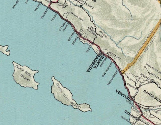
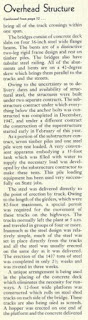
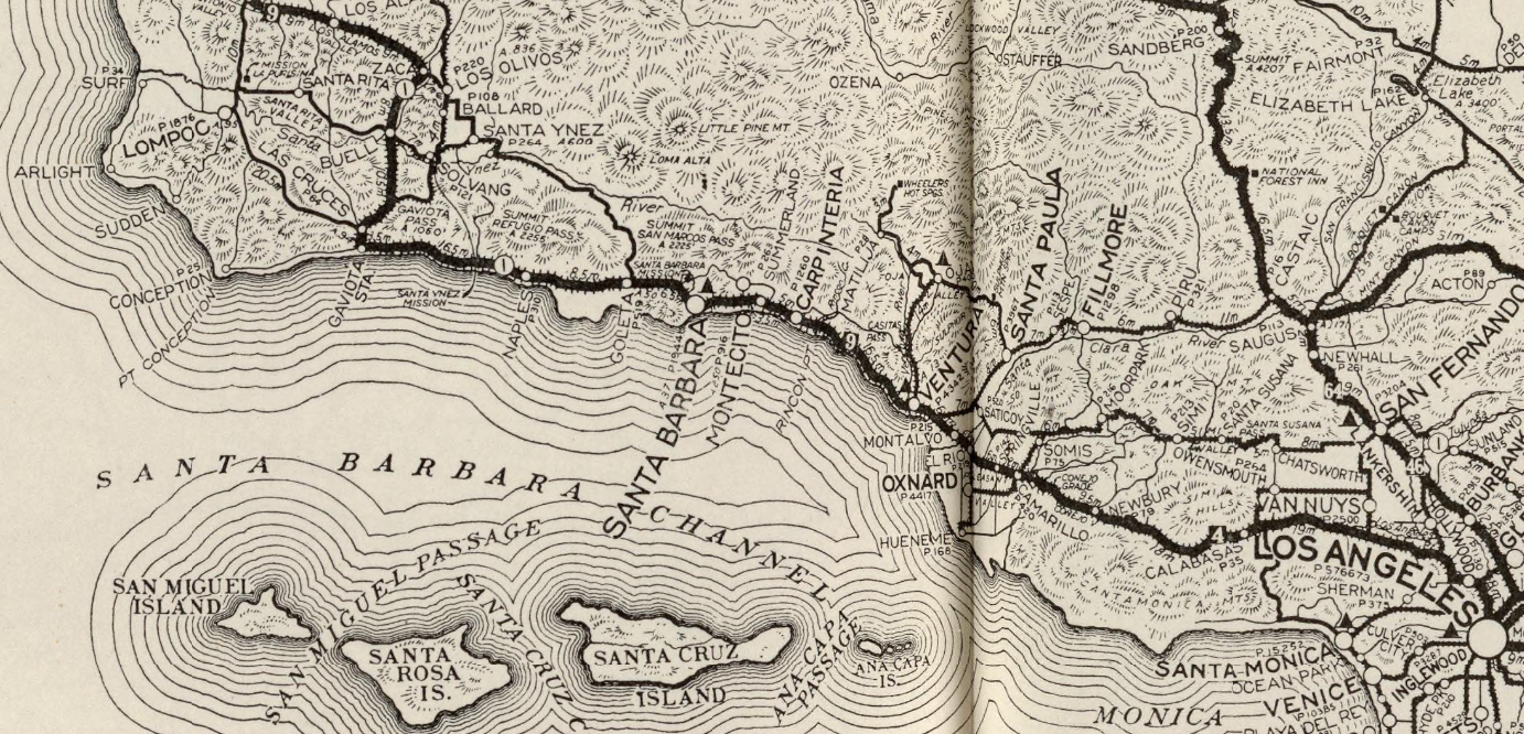
US Route 101 southbound upon traversing Gaviota Pass in Santa Barbara County emerges onto Santa Barbara Channel and begins a generally eastward jog towards Oxnard Plain of Ventura County. US Route 101 along Santa Barbara Channel is one of the oldest and most historic overland corridors in California which has ties to Spanish El Camino Real. While modern US Route 101 along Santa Barbara Channel is carried by either freeway or expressway grades there are numerous former surface alignments of note. This blog features the history of US Route 101 in the communities of; Gaviota siding, Orella siding, Naples siding, Ellwood siding, Goleta, Santa Barbara, Montecito, Summerland, Carpinteria, Sea Cliff, Dulah siding and Ventura. Featured above is the Rincon Road Causeway between Carpinteria and Ventura as seen in a photo dated to 1912.
Part 1; the history of US Route 101 along Santa Barbara Channel
The shores of Santa Barbara Channel lie within a narrow coastal plain which backs up to the Santa Ynez Mountains. Santa Barbara Channel was first explored by Spanish during the 1769 Portola Expedition of Las Californias. Upon traversing the shores of Santa Barbara Channel the Portola Expedition opted to follow the coastline northward fearing that the established Chumash path through Gaviota Pass was too narrow to traverse. In time Santa Barbara Channel and Gaviota Pass became a favored established path of Spanish travel as part of El Camino Real.
The route of El Camino Real was intended to solidify a path of travel between the Catholic Missions of Las Californias. In 1804 Alta California was formed out of the larger Las Californias. El Camino Real would ultimately connect twenty one Catholic Missions of Alta California ranging approximately 600 miles spanning from Mission San Diego de Alcala in San Diego north to Mission San Francisco Solano in Sonoma. Two Missions could be found along El Camino Real on the shores of Santa Barbara Channel; Mission Santa Barbara and Mission Basilica San Buenaventura. Mission Basilica San Buenaventura was founded on March 31st, 1782 whereas Mission Santa Barbara was founded on December 4th, 1786.
During August 1833 in period of Mexican Alta California the Spanish Missions were secularized. The secularization of the Spanish Missions gradually led to most of their lands being granted as Ranchos. Mission Santa Barbara became the hub for most of the documents that were once housed in the Spanish Missions along El Camino Real. Despite usage of the name "El Camino Real" declining following the secularization of the Spanish Missions the communities centered around them remained important destinations. Thusly travel along the former path of Spanish El Camino Real remained a favored corridor of overland travel through the Mexican-American War and emergence of the American State of California.
A coastal highway along Santa Barbara Channel can be seen on the 1857 Britton & Rey's Map of California. Note; Ventura County would not split from Santa Barbara County until March 1872.
The coastal highway along Santa Barbara Channel can be seen on the
1873 Bancroft's Highway Map of California.
Santa Barbara Channel was ultimately part of the
American El Camino Real which began being signed as an Auto Trail starting in 1906. The era of State Highway Maintenance through Santa Barbara Channel would ultimately begin with the 1909 First State Highway Bond Act which was approved by voters in 1910. One of the highways approved through the 1909 First State Highway Bond Act was a 481.8 mile highway originating at the City Limits of San Francisco which terminated in San Diego. This highway would ultimately come to be known in time as
Legislative Route Number 2 ("LRN 2").
The
October 1912 California Highway Bulletin describes the Rincon Road Causeway between Carpinteria and Ventura as being built at a cost of $32,000. The Rincon Road Causeway is stated to have been turned over to the California Highway Commission for completion. The Rincon Road Causeway is cited to be 4.4 miles in length.
In 1913 the Pacific Highway was plotted as a major Auto Trail which had Santa Barbara Channel along it's planned route. The
May 1913 California Highway Bulletin references numerous Santa Barbara County locals purchasing State Highway Bonds to aid in the construction of LRN 2 between Ellwood and Gaviota Pass.
The
July 1914 California Highway Bulletin cites LRN 2 from Carpinteria south to Ventura County Line as being recently completed to State Standards. A segment of LRN 2 from Sea Cliff to the Rincon Road Causeway is cited to have been awarded.
The
January 1915 California Highway Bulletin describes work on the Rincon Route Seawall segment of LRN 2 as progressing rapidly. The Rincon Route Seawall is described as being a necessary component in shifting LRN 2 off of Casitas Pass onto a less hazardous route between Santa Barbara and Ventura. Note; prior to the completion of the Rincon Road Causeway traffic following the shore of Santa Barbara Channel had to wait for low tides or detour over Castias Pass to travel between Santa Barbara-Ventura.
The
July 1916 California Highway Bulletin displays a segment of LRN 2 west of Ventura before and after it was built to State Standards.
Early LRN 2/American El Camino Real/Pacific Highway can be seen traversing Santa Barbara Channel on the
1917 California State Automobile Association Map. The new alignment of LRN 2 along the coast bypassing Castias Pass between Santa Barbara and Ventura can be observed.
In 1918 the Arroyo Hondo Bridge was completed over the namesake creek between Gaviota siding and Ellwood siding. The 1918 Arroyo Hondo Bridge is a 536 foot long open spandrel arch concrete bridge which was among the earliest of such design built as part of a State Highway. The 1918 Arroyo Hondo Bridge can seen in this photo hosted on bridgehunter.com.
The 1920 Rand McNally Highway Map of California shows El Camino Real and the Pacific Highway following LRN 2 through Santa Barbara Channel.
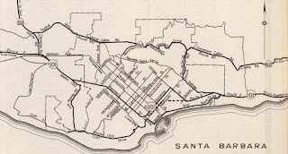
The below 1920 Automobile Club of Southern California map shows the through route of the Pacific Highway/El Camino Real and implied connections to LRN 2 through Santa Barbara. The Pacific Highway/El Camino Real southbound is shown to follow; State Street, De La Vina Street, Micheltorena Street, State Street, Montecito Street, Milpas Street, Cacique Street, Salinas Street and what is now Old Coast Highway. The Pacific Highway/El Camino Real northbound is shown to follow; Old Coast Highway, Salinas Street, Cacique Street, Milpas Street, Haley Street, State Street, Mission Street, De La Vina Street and State Street. Note; it wasn't until 1933 until the State could maintain highways within incorporated cities.
The 1924 Rand McNally Map of California shows the California Banff Bee-Line Highway co-signed with the Pacific Highway through Santa Barbara Channel.
The
October 1924 California Highways & Public Works features an article detailing the history of State Highway development on Santa Barbara Channel north of Santa Barbara. LRN 2 is described as having been graded north of Santa Barbara from 1915-1917 with 15 foot wide slabs of concrete being laid in 1917. LRN 2 north of Santa Barbara is stated to have been expanded to a minimum 30 foot width by 1922. The article features numerous photos of the Arroyo Hondo Bridge.
The initial draft of the US Route System was approved by the Secretary of Agriculture during November of 1925. The US Route System within California was approved by California Highway Commission with no changes recommended by
January 1926. The initial alignment of US Route 101 ("US 101") was planned to follow LRN 2 from San Francisco to San Diego via Santa Barbara Channel. US 101 is shown on a map published in the 1926 California Highways & Public Works following LRN 2 south from San Francisco towards San Diego.
The
January 1926 California Highways & Public Works describes LRN 2 south of Santa Barbara through Montecito as being recently expanded to 30 feet in width.
The February
1926 California Highways & Public Works features the upcoming new alignment of LRN 2 through Summerland and Ortega Hill. The new alignment of LRN 2 in Summerland is shown to be planned to follow Lillie Avenue over a new 6.4% grade over Ortega Hill. The existing Ortega Hill alignment in Summerland is shown to carry a grade of 8.8%. Ortega Hill is stated to have been named after Spanish Captain Jose Francisco Ortega.
The
February 1926 California Highways & Public Works notes reconstruction of LRN 2 through Carptineria had begun. The existing surface of LRN 2 through Carpinteria is stated to be slated for expansion to 30 feet in width.

The
June 1926 California Highways & Public Works cites the realignment of LRN 2 through Summerland and Ortega Hill as opening on June 3rd, 1926. Widening of LRN 2 between Goleta and Santa Barbara is stated to be underway.
The
November 1926 California Highways & Public Works notes the Rincon Seawall had recently opened as a replacement of the Rincon Road Causeway between Sea Cliff and El Rancho Rincon. The Rincon Road Causeway is cited to have been removed during the construction of the Rincon Seawall. The Rincon Seawall is stated to have reclaimed a 6,400 foot segment of land that was necessary to expand LRN 2. The Santa Barbara Earthquake is cited to have caused no apparent damage to the Rincon Seawall.
The Rincon Seawall appears as the cover photos on the
November 1926 California Highways & Public Works.

During November of 1926 the US Route System was approved by the AASHO. US 101 can be seen aligned along Santa Barbara Channel on the
1927 National Map Company Sectional Map.
The
December 1927 California Highways & Public Works features an article which shows how traffic was kept moving along LRN 2 when Rincon Seawall was being paved. The paving of the Rincon Seawall is stated to be part of a 12.5 mile long contract which took approximately 11 months to complete.
The
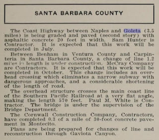
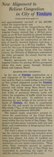
July/August 1929 California Highways & Public Works announced US 101/LRN 2 from Naples to Goleta was being expanded an additional 20 feet in width. The Naples-Goleta expansion of US 101/LRN 2 is stated to have an expected completion during July 1929. US 101/LRN 2 between Carpinteria south over the Ventura County Line to Benham is stated to be in the process of being realigned. The Carpinteria-Benham realignment of US 101/LRN 2 is stated include an overhead crossing of the Southern Pacific Railroad. The new overhead structure is cited to be a replacement for a substandard rail subway and was expected to be complete by October 1929.
The
February 1932 California Highways & Public Works announced the City of Ventura and State was slated to participate in the cooperative construction of a new alignment of US 101. US 101 was originally aligned through congested downtown Ventura via Main Street. The new alignment of US is cited to be planned to diverge from Main Street via Garden Street and Meta Street (now Thompson Boulevard).
The
April 1932 California Highways & Public Works announced the existing two lane Ventura River Bridge was slated to be replaced by a four lane structure to facilitate more efficient travel on US 101/LRN 2. The new Ventura River Bridge is stated to be planned to incorporate the piers of the older structure.
The
May 1932 California Highways & Public Works cites the Ventura River Bridge became an advertised project during the previous March. The Ventura River Bridge project is cited to tie in with planned cooperative realignment of US 101 through the City of Ventura.
The
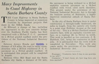
January/February 1933 California Highways & Public Works lists numerous projects to upgrade US 101/LRN 2 in Santa Barbara County during the 1933-35 Fiscal Years. US 101/LRN 2 is cited to have a budgeted reconstruction project for 5.3 miles from Gaviota to Arroyo Hondo. The Hollister Avenue Subway project is stated to be planned to connect with the proposed realignment of US 101/LRN 2 in the City of Santa Barbara. A third project from Ortega Hill through Montecito to the City Limits of Santa Barbara is cited to also tie in with the planned realignment of US 101/LRN 2.
The
May/June 1933 California Highways & Public Works lists the new Ventura River Bridge being constructed by the State as part of US 101/LRN 2. The stub article also cities the cooperative realignment construction of US 101/LRN 2 within the City of Ventura being underway.
The
January 1934 California Highways & Public Works announced the new four lane Ventura River Bridge opened during late 1933. The article goes onto state that the new alignment of US 101/LRN 2 through Ventura onto Garden Street and Thompson Boulevard was also completed. The new alignment of US 101/LRN 2 connected back with Main Street east of downtown Ventura and followed it towards the Santa Clara River and Oxnard.
The
May 1934 California Highways & Public Works features construction of a new overhead structure of the Southern Pacific Railroad west of the Ventura River. The Ventura Overhead structure is shown to be a realignment of existing US 101/LRN 2 from a obsolete rail subway. The Ventura Overhead is stated to require a short lengthening of the existing seawall and was expected to be completed during Fall 1934.
The
June 1934 California Highways & Public Works notes several improvements to US 101/LRN 2 on Santa Barbara Channel. A new overpass over the Southern Pacific Railroad in Ellwood is cited to have been recently completed as a realignment of US 101/LRN 2. US 101/LRN 2 between Gaviota siding and Arroyo Hondo is stated to be undergoing the process of being expanded to a 36 foot wide road surface. A new six lane boulevard within the City of Santa Barbara is stated to be in the process of construction.
The
July 1934 California Highways & Public Works features the nearly completed realignment of US 101/LRN 2 through the City of Santa Barbara. The new alignment of US 101/LRN 2 in Santa Barbara is stated to be 5.9 miles in length and would feature a six lane boulevard which included several new bridges over Mission Creek. The existing alignment of US 101/LRN 2 southbound through Santa Barbara is shown to follow; State Street, De La Vina Street, Gutierrez Street, Milpas Street, Cacique Street, Salinas Street and Old Coast Highway. The new alignment of US 101/LRN 2 through Santa Barbara is stated to have an anticipated opening during November 1934.
The
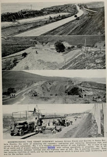
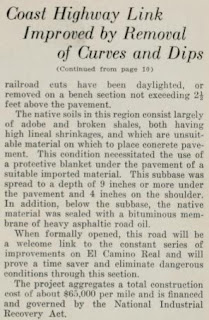
September 1934 California Highways & Public Works features the recently completed upgrade of US 101/LRN 2 between Gaviota siding and Arroyo Hondo. The Gaviota-Arroyo Hondo upgrade of US 101/LRN 2 eliminated 31 curves via a straightened alignment.

The
September 1934 California Highways & Public Works features an article pertaining to the reconstruction of the existing Rincon Seawall from Ventura 8.47 miles northward on US 101/LRN 2 to Mussel Shoals. Use of steel seawalls is cited as being necessary to widen US 101/LRN 2 from a 30 foot road surface to 80 feet. The flow of US 101/LRN 2 through Montecito was improved as part of the recently completed Santa Barbara project via a new overhead structure.
The 1935 Division of Highways Maps of
Santa Barbara County and
Ventura County feature US 101/LRN 2 following all the major improvements made to the highway along Santa Barbara Channel during the early 1930s.
The
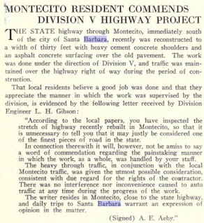
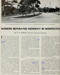
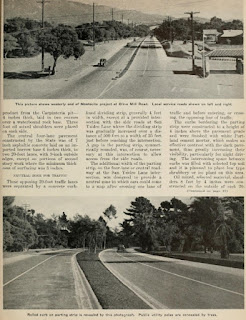
January 1938 California Highways & Public Works features an article showcasing the expansion of US 101/LRN 2 to a divided four lane highway in Montecito. The expansion of US 101/LRN 2 through Montecito is stated to have been completed during October 1937 and was a continuation to the improved highway built through Santa Barbara in 1934. .

The
June 1940 California Highways & Public Works features a progressing upgrade to US 101/LRN 2 from El Captain Creek to Orella siding. The existing highway is described as having a 6.5% grade compared to the new four lane divided grade stated to be 2.23%. The new alignment of US 101/LRN 2 is stated to have anticipated opening during October 1940.
The
October 1941 California Highways & Public Works discusses the expansion of US 101/LRN 2 to four lanes between Las Varas Creek 3.4 miles to Tecolote Creek and Orella siding 1 mile west of Canada del Refugio. The Las Varas-Tecolote Creek rebuild of US 101/LRN 2 is stated to be another step in the expansion of the highway spurred by development out of Montecito and Santa Barbara. This segment of US 101/LRN 2 is cited to have had a secondary project to construct a new bridge over Dos Pueblos Creek which was completed by March 1941. The Las Varas-Tecolote Creek reconstruction project included an improvements US 101/LRN 2 through Naples siding.

The
March/April 1947 California Highways & Public Works discusses a recently upgraded segment of US 101/LRN 2 extending from the City Limit of Santa Barbara 9.3 miles northward to Tecolote Canyon. This new alignment of US 101/LRN 2 is cited to have replaced Hollister Avenue through Goleta between the Hollister Underpass and the newly constructed Ellwood Overhead. The relocation of US 101/LRN 2 through Goleta was spurred by interests from the U.S. Marine Corps Station during World War II. The realignment of US 101/LRN 2 from Santa Barbara to Tecolote Creek was constructed during three projects, the last concluding during March 1947.
The bypass of Hollister Avenue and Goleta first appears on the
1948 Division of Highways State Map.
The start of the Salsipuedes Street Overhead in Santa Barbara is discussed in the
March 1948 California Highways & Public Works. The Salsipuedes Street Overhead project was the beginning phase of a realignment of US 101/LRN 2 off of Gutiterrez Street onto a expressway bypass.
The
January/February 1949 California Highways & Public Works discusses the opening of the Santa Barbara Freeway. The Santa Barbara Freeway (closer in design to a modern expressway) opened on November 18th, 1948 and realigned US 101/LRN 2 onto a bypass of Guiterrez Street.
The Santa Barbara Freeway first appears on the
1949 Division of Highways State Map.
The early phase of the four lane expansion of 1.2 miles of US 101/LRN 2 on the Rincon Seawall appears in the
January/February 1949 California Highways & Public Works. The expansion of the Rincon Seawall is stated to have anticipated completion during May 1949.
The
September/October 1949 California Highways & Public Works cities the 1.2 mile expansion of US 101/LRN 2 on the Rincon Seawall as being completed by late July 1949. The article pictures some previously unseen photos of the Rincon Seawall.
The
January/February 1950 California Highways & Public Works discusses the expansion of US 101/LRN 2 to a freeway between Arroyo Hondo and Arroyo Quemando. The expansion of US 101/LRN 2 between Arroyo Hondo-Arroyo Quemando led to both existing bridges being converted to southbound usage.
The ongoing conversion of US 101/LRN 2 in Summerland to expressway standards is discussed in the
November/December 1951 California Highways & Public Works. The expansion of US 101/LRN 2 is stated to be an extension of the Montecito Parkway and would extend east to the Ventura County Line through a new grade in Carpinteria.
The July/August 1952 California Highways & Public Works announced US 101/LRN 2 had moved to the Montalvo Freeway from the Santa Clara River northward into Ventura. The Montalvo Freeway is cited as the last limited access component that was necessary to connect Ventura-Oxnard with a partially limited access grade.
July/August 1954 California Highways & Public Works cites a three mile segment of US 101/LRN 2 from Punta Gorda (Mussel Shores) to the Santa Barbara County Line as going through the process of conversion to a four lane expressway. The same volume cities the new alignment of US 101/LRN 2 on a expressway bypass of Carpinteria as being the process of paving.
The ongoing construction of the four lane expressway expansion of US 101/LRN 2 from Punta Gorda to the Santa Barbara County Line is featured in the J
anuary/February 1955 California Highways & Public Works. The difficulties of expanding the Rincon Seawall to amid the conditions in Santa Barbara Channel are discussed.
The
March/April 1955 California Highways & Public Works discusses the opening of the Carpinteria Expressway during December 1954. The Carpinteria Expressway shifted US 101/LRN 2 north of downtown Carpinteria and the previous alignment on Carpinteria Avenue.
The May/June 1955 California Highways & Public Works discusses the recent conversion of US 101/LRN 2 from Central Avenue in Ventura the Santa Clara River to freeway standards. The freeway segment of US 101/LRN 2 terminated at the City of Ventura and emptied onto Main Street just south of Telegraph Road/Thompson Boulevard.
The
January/February 1957 California Highways & Public Works notes a design study was underway to extend the Ventura Freeway through the City of Ventura where US 101/LRN 2 would be relocated.
The
January/February 1957 California Highways & Public Works notes US 101/LRN 2 near Summerland and Ortega Hill was under a resolution to be converted to full freeway standards. US 101/LRN 2 through Montecito is cited to have been converted to freeway standards by August 1956. US 101/LRN 2 through Goleta is stated to be in the process of full freeway conversion. US 101/LRN 2 from Ellwood to Orella is stated to be under an active contract about to begin for a full freeway conversion.
The
September/October 1958 California Highways & Public Works notes that the expansion of US 101/LRN 2 between Ellwood and Orella was nearing completion. Construction of a four lane expressway from Refugio Canyon and Refugio Beach Park is stated to have been completed during January 1958.
The
September/October 1958 California Highways & Public Works announced details on the upcoming upgrade of US 101/LRN 2 in the Montecito-Ortega Hill corridor and in Santa Barbara. The Montecito-Ortega Hill corridor project is noted to include frontage roads and numerous interchange structures. Within Santa Barbara US 101/LRN 2 was slated to be reconstructed to include a full freeway interchange with Milpas Street.
The
January/February 1959 California Highways & Public Works announced financing for the Ventura Freeway extension through Ventura was earmarked for the 1959-1960 and 1960-1961 Fiscal Years. The Ventura Freeway extension was stated to include an interchange with the already complete Ojai Freeway which was carrying US 399.
The
September/October 1959 California Highways & Public Works announced US 101/LRN 2 had been completed to freeway standards through Montecito-Ortega Hill. The new Milpas Street interchange in Santa Barbara is stated to be nearing completion. An expansion of US 101/LRN 2 from Bath Street/Salsipuedes Overhead west to El Sueno Road is cited to have been in the proposal stages. The Bath Street-El Sueno Road segment of US 101/LRN 2 in Santa Barbara is cited to have been heavily built up since it opened which would make freeway conversion difficult. Plans are stated to be in development to convert the remaining expressway segments of US 101/LRN 2 south from Ortega Hill to the Ventura County Line to freeway standards.
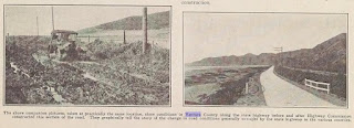
The
March/April 1960 California Highways & Public Works features a comparison of the 1912 photo of the Rincon Causeway to the Rincon Seawall in 1959.
The
March/April 1961 California Highways & Public Works cites construction of the Ventura Freeway extension through the City of Ventura as having begun during March 1960. The extension of the Ventura Freeway through Ventura is stated to have an anticipated completion during March 1962.
The
May/June 1962 California Highways & Public Works display an aerial photo and article of the recently completed freeway segment of US 101/LRN 2 through Goleta. The Goleta segment of US 101/LRN 2 is cited to have been the last two lane segment of the highway in southern Santa Barbara County. The Goleta freeway conversion of US 101/LRN 2 is stated to begin at the City Limits of Santa Barbara and extend to Ellwood Station.
The
September/October 1962 California Highways & Public Works cites a planned extension of the Ventura Freeway from the Ventura Overhead to the Santa Barbara County Line was in development. The planned extension of the Ventura Freeway would see US 101/LRN 2 be relocated uphill above the Rincon Seawall and Southern Pacific Railroad. The relocation of US 101/LRN 2 above the Rincon Seawall is cited to have a target starting point within three to four years.
The
September/October 1962 California Highways & Public Works displays the ongoing freeway construction in Ventura County. The Ventura Freeway through the City of Ventura is shown to be near completion is stated to have a likely opening during late October 1962. The extension of the Ventura Freeway would serve to remove US 101/LRN 2 from Main Street/Garden Street/Thompson Boulevard through the City of Ventura and connect with the Ojai Freeway/US 399 via an interchange structure.
During 1964 the California Highway Renumbering occurred. All Legislative Route Numbers were dropped along with many of the US Routes. California State Route 1 ("CA 1") was extended from Las Cruces southward through Santa Barbara Channel on a multiplex of US 101 to what was US 101A/LRN 60 in Oxnard. The new multiplex of CA 1 on US 101 from Las Cruces to Oxnard first appears on the
1964 Division of Highways State Map.
The
November/December 1965 California Highways & Public Works cities the remaining expressway segments of US 101/CA 1 between Summerland and Carpinteria were slated for freeway conversion.
The California Highways & Public Works publication ended in 1967. The planned freeway realignment of US 101 above the Rincon Seawall first appears on the
1967 Division of Highways State Map. US 101/CA 1 between Summerland and Carpinteria are shown to be upgraded to freeway standards.
According to cahigways.org
CA 1 was spun off onto its own alignment away from US 101 on the Rincon Seawall as part of 1980 Legislative Chapter 740. This new standalone segment of CA 1 on the Rincon Seawall was created after US 101 had been moved uphill above the Union Pacific Railroad onto a freeway grade.
According to a
Los Angeles Times Article dated April 19th, 1988 the remaining four traffic lights on US 101/CA 1 in Santa Barbara were slated to be removed from the Chappla Street-Milpas Street corridor. The final freeway conversion of US 101/CA 1 through Santa Barbara is stated to have an anticipated completion during 1991. US 101/CA 1 through Santa Barbara can be seen on the
1990 Caltrans State Map with a small expressway gap. The traffic lights in Santa Barbara were the last between downtown Los Angeles and San Francisco on US 101. The removal of the traffic lights in Santa Barbara also provided US 101 with a continuous freeway grade from downtown Los Angeles through Goleta.
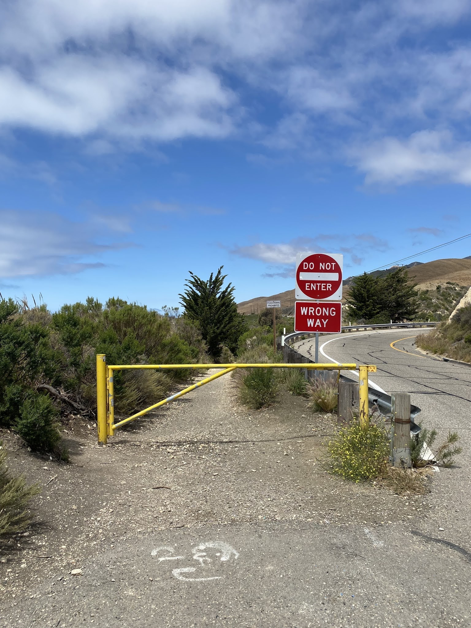
Part 2; former US Route 101 on the 1918 Arroyo Hondo Bridge
US 101/CA 1 southbound crosses Arroyo Hondo where a Vista Point can be found at Postmile SB 40.878. The derelict 1918 Arroyo Hondo Bridge can be found at the US 101/CA 1 Vista Point.
As stated in Part 1 the
Arroyo Hondo Bridge served both lanes of US 101 until 1950 when it was converted to southbound usage. The Arroyo Hondo Bridge was bypassed in
1984 when a new bridge was constructed to carry US 101/CA 1.
Santa Barbara Channel and the Channel Islands can be seen from the Vista Point directly east of the Arroyo Hondo Bridge.
Part 3; former US Route 101 in Goleta and Santa Barbara
Former US 101 in Goleta and Santa Barbara can be accessed via US 101/CA 1 southbound Exit 110 onto Hollister Avenue in the City of Goleta.
Former US 101 upon departing the modern freeway follows Hollister Avenue into Goleta. One of the last traces of the Ellwood siding can be found as Hollister Avenue intersects Ellwood Station Road. Goleta incorporated as a City during 2002 and annexed the lands which once part of Ellwood siding.
Former US 101 on Hollister Avenue Goleta passes by Santa Barbara Airport. Access to Amtrak service can be found as Hollister Avenue intersects La Paterna Lane.
Former US 101 on Hollister Avenue passes through downtown Goleta and passes under CA 217.
Former US 101 on Hollister Avenue departs the City of Goleta. Former US 101 follows Hollister Avenue under the Union Pacific Railroad and enters the City of Santa Barbara on State Street.
Former US 101 on State Street intersects CA 154/San Marcos Pass Road.


Former US 101 southbound as stated in Part 1 would have followed State Street into downtown Santa Barbara and merged right onto De La Vina Street.
Former US 101 on De La Vina Street is now mostly aligned one-way southbound. Traffic can follow former US 101 on De La Vina Street only to Guiterrez Street southbound. Guiterrez Street has largely been converted to one-way only northbound traffic which requires southbound traffic to use Haley Street to reach Milpas Street. Milpas Street and Cacique Street no longer meet as the intersection lies under what is now the US 101/CA 1 freeway.
Part 4; former US Route 101 over Ortega Hill and Summerland
Modern US 101/CA 1 southbound climb over Ortega Hill into Summerland via a freeway grade. Former US 101 on Lillie Avenue in Summerland can be spied from the freeway upon summiting Ortega Hill. Summerland traces it's origins to a spiritualist by the name of H.L. Williams who settled in the area in 1883. Williams subdivided his property in 1888 which would soon boom into the community of Summerland following exploitation of the Summerland Oil Field in the 1890s.
Part 5; former US Route 101 in Carpinteria
Modern US 101/CA 1 southbound accesses former US 101 in Carpinteria via Exit 87B onto Carpinteria Avenue.
Former US 101 on Carpinteria Avenue passes through downtown Carpinteria. Carpinteria was the site of a Chumash Village known as Sujtu which the Portola Expedition encountered in 1769. The Spanish called the Chumash village "La Carpinteria" due to a carpentry shop being located there. Carpinteria would incorporate as a City during September of 1965.
As former US 101 on Carpinteria Avenue passes Palm Avenue it picks up what was once CA 224.
CA 224 would have departed former US 101/Carpinteria Avenue via Castitas Pass Road.
Former US 101 follows Carpinteria Avenue south of Carpinteria towards Rincon Point and modern US 101/CA 1.
Part 6; former US Route 101/current California State Route 1 on the Rincon Seawall
As noted in Part 1 CA 1 diverges from US 101 onto a standalone alignment along the Rincon Seawall at Sea Cliff via Exit 78 onto Pacific Coast Highway. Modern US 101 has been shifted to a freeway grade on higher terrain above the Union Pacific Railroad whereas CA 1 has subsumed it's original alignment on the Rincon Sewall.
At Postmile VEN 27.218 CA 1 southbound passes by Hobson County Park.
CA 1 southbound opens up onto a vista of Santa Barbara Channel and a sign announces the recreational vehicle regulations of the "Rincon Parkway."
CA 1 on the Rincon Seawall is signed as the Ventura County Vietnam Veterans Memorial Highway.
At Postmile VEN 25.555 CA 1 southbound passes by Faria County Park.
CA 1 southbound passes through a small community of Dulah siding on the Rincon Seawall and merges back into US 101 approaching the City of Ventura.
Part 7; scenes on former US Route 101 in Ventura
The photo below displays a scene on Main Street in downtown Ventura at the intersection with Ventura Avenue. As noted in Part 1 Main Street was the original alignment of US 101 in downtown Ventura. Ventura Avenue upon completion of the Maricopa Highway would become part of US 399. US 399's original terminus would have been carried a block north to via Main Street to US 101 at Garden Street.
The second surface alignment of US 101 on Thompson Boulevard is still signed on US 101 Business.


Comments