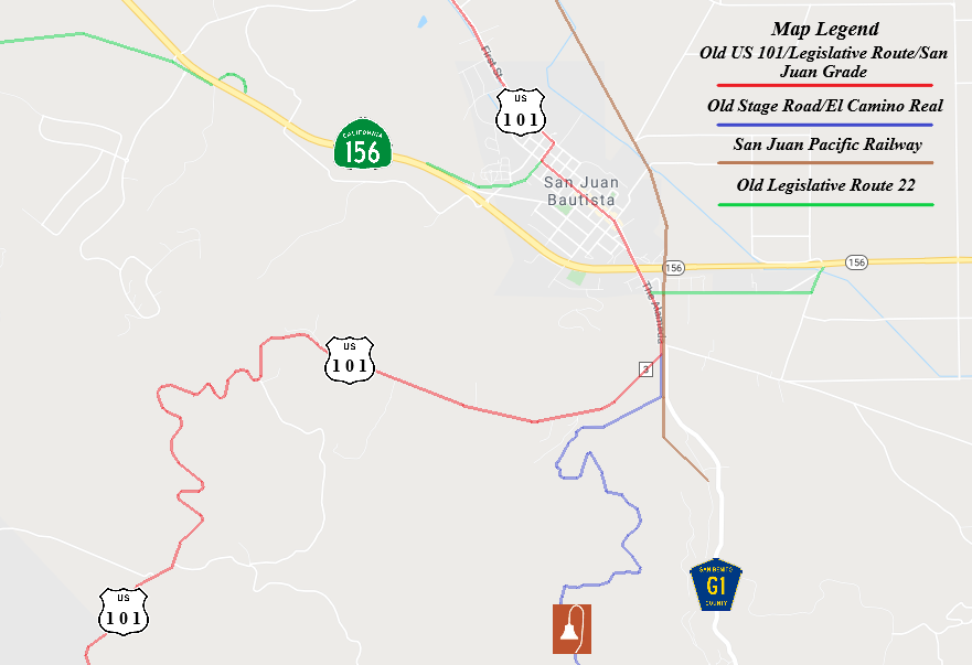
Old Stage Road; the "real" El Camino Real and predecessor route to US Route 101 on the San Juan Grade
This past month I stopped in San Juan Bautista to hike the Juan Bautista De Anza Trail on the closed Old Stage Road. Old Stage Road as part of the Spanish El Camino Real to cross the Gabilan Range between San Juan Bautista and Salinas Valley.

Part 1; the history of El Camino Real and Old Stage Road
The Gabilan Range between what is now San Juan Bautista and Salinas Valley was first explored during the second Juan Bautista De Anza Expedition of Las Californias. While the De Anza expedition likely crossed very close to the present alignment of Old Stage Route their exact path isn't clear. Juan Bautista De Anza noted the following in his journal while passing near present day San Juan Bautista on March 24, 1776:
"In the valley we saw many antelopes and white grey geese. In the same valley we found an arroyo...and then came to a village in which I counted about twenty tule huts. But the only two people we saw were two Indians who came out to the road and presented us with three fish more than a foot long."
In time the general route of the second De Anza Expedition became the path of El Camino Real ("The Royal Road"). The route of El Camino Real was intended to solidify a path of travel between the Catholic Missions of Las Californias. In 1797 Mission San Juan Bautista was founded which led to a need for a spur of El Camino Real to be built from Salinas Valley over the Gabilan Range. This spur of El Camino Real would become what is now Old Stage Road. While the Spanish El Camino Real was largely just a general path between the Missions there are identifiable paths such as Old Stage Road which can be identified conclusively as part of the highway.
In 1804 Alta California was formed out of the larger Las Californias. El Camino Real would ultimately connect 21 Catholic Missions of Alta California ranging approximately 600 miles spanning from Mission San Diego de Alcala in San Diego north to Mission San Francisco Solano in Sonoma. The Missions of El Camino Real were established from 1769 through 1823. In the case of Mission San Francisco Solano it was established two years after Mexico had won it's independence from Spain in 1821. Each Mission was meant to be approximately 30 miles apart from each other which would require a single day of travel by horseback.
Following the advent of Mexican independence from Spain the usage of the term "El Camino Real" largely fell into disuse. Following the secularization of the Spanish Missions in August of 1833 the land holdings were split off into Ranchos. Despite El Camino Real functionally no longer existing the route it's path over what is now Old Stage Road remained a popular route of travel over the Gabilan Range. What is now San Juan Bautista was founded as a town in 1834 known at the time as "San Juan de Castro."
Alta California was annexed by the United States in early 1848. San Juan Bautista became an incorporated City in 1869 (citation; San Juan Bautista Historical Society). San Juan Bautista was originally located in Monterey County but was among the land split into San Benito County in 1874. Old Stage Road remained the primary route of travel between Salinas Valley and San Juan Bautista into the 20th Century.
Old Stage Road shows up numerous American Maps as a primitive road. One such example is this 1857 Britton & Rey's Road Map of California.

Likewise Old Stage Road appears on the 1873 California Geological Survey Map of Central California as the road between Salinas Valley and San Juan Bautista.

In 1904 the American El Camino Real Association was formed with the goal to mark a modern highway that corresponded to the historical route between the Spanish Missions. Ultimately the path of American El Camino Real was to be marked by the signature bells the corridor is known by today. The first bell marking the American El Camino Real was placed in 1906 and it is estimated by 1915 that there may have been anywhere to 158 to 400 placed in-field. The American El Camino Real was one of the earliest analogs of what would become the signed Auto Trails. The American El Camino Real just as it's Spanish predecessor crossed the Gabilan Range via Old Stage Road. The background of the American El Camino Real is covered extensively on CAhighways.org.
CAhighyways.org on the American El Camino Real
The era of State Highway Maintenance through the Gablian Range would ultimately begin with the 1909 First State Highway Bond Act which was approved by voters in 1910. One of the highways approved through the 1909 First State Highway Bond Act was a 481.8 mile highway originating at the City Limits of San Francisco which terminated in San Diego. This highway would ultimately come to be known in time as Legislative Route Number 2.
Old Stage Road even by the conventions of the 1910s was woefully inadequate for usage by automobiles. The terrain of the Gabilan Range between San Juan Bautista and Salinas Valley was so rugged that an alternate route from Gilroy to Salinas by way of Watsonville and Castroville was considered. This 1913 highway proposal of LRN 2 shows what could have been an alternate highway routed west from San Juan Bautista.

Ultimately the San Juan Grade was completed by 1915 and replaced Old Stage Road as the primary highway from Salinas to San Juan Bautista. LRN 2 over the San Juan Grade can be seen as the 1920 Denny's Pocket Map of San Benito County. Note; Old State Road is shown on the 1920 Denny's Map as an abandoned road.

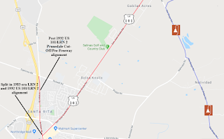
Ultimately LRN 2 and the San Juan Grade became part of US Route 101 in late 1926. US 101/LRN 2 was ultimately shifted west of San Juan Bautista and the San Juan Grade onto what is known as the Prunedale Cut-Off in summer of 1932. This construction of the Prunedale Cut-Off bypass route of the San Juan Grade can be seen on the October 1931 edition of the California Highways and Public Works Journal and on CAhighways.org Legislative Route 2 page.


The San Juan Grade was relinquished sometime in 1935 or 1936. It seems that at some point after 1920 maintenance of Old Stage Road was picked up by San Benito County and Monterey County. Old Stage Road appears as an active roadway on the 1935 Division of Highways Maps of San Benito County and Monterey County.
San Benito County

Monterey County

Maintenance of Old Stage Road between Monterey County and San Benito County has varied greatly. Over the recent decades Old Stage Road in Monterey County has become a normal back country roadway between US 101 near Gonzales to the San Benito County Line. Old Stage Road on the Monterey County side is a paved highway all the way to a half mile of the San Benito County Line in French Canyon of the Gabilan Range.
Within San Benito County the route of Old Stage Road is approximately 4.3 miles. From the Monterey County Line the route of Old Stage Road is a graded dirt road for 4 miles. The 4 mile dirt segment of Old Stage Road is closed to vehicles 364 days a year to the Juan Bautista De Anza Trailhead. From the Juan Bautista De Anza Trailhead the alignment of Old Stage Road continues as a paved roadway 0.3 miles to former US 101 on the San Juan Grade (signed as Salinas Road in San Benito County).
Old Stage Road within San Benito County was open to traffic until fairly recently. Presently the 4 mile dirt segment of Old Stage Road is maintained by the National Park Service as a historic portion of the Juan Bautista De Anza Trail. A local vintage car club out of Salinas opens the 4 mile dirt segment of Old Stage Road once a year generally the weekend before Mother's Day so it can maintain it's status as an active highway. Unfortunately in my research I haven't been able to track down the name of the car club involved in opening the dirt segment of Old Stage Road to vehicles.
In preparation for this article I prepared numerous maps of the San Juan Bautista and Salinas area which show the corridors of the historic highways in the the area. The route of Old Stage Road is depicted in blue below whereas former US 101 on the San Juan Grade is depicted in red. It is interesting to note how much shorter of a route Old Stage Road utilizes to cross the Gablian Range due to it's less forgiving steep grades.


Part 2; running to the summit of Old Stage Road
While passing through San Juan Bautista I had some time to stop and partake in a short hike up Old Stage Road. To reach Old Stage Road from California State Route 156 eastbound I turned south on County Route G1 onto The Alameda (part of former US 101).


To reach Old Stage Road I stayed on The Alameda and followed it to Salinas Road. County Route G1 splits away on San Juan Canyon Road towards Fremont Peak State Park.


Old Stage Road splits from Salinas Road and can easily be identified by Juan Bautista De Anza Historic Trail shield.

Old Stage Road briefly follows the alignment of the San Juan Pacific Railway which was located to the left in the photo below. The San Juan Pacific Railway had a terminus in San Juan Canyon where it hauled cement from 1907 to 1930.

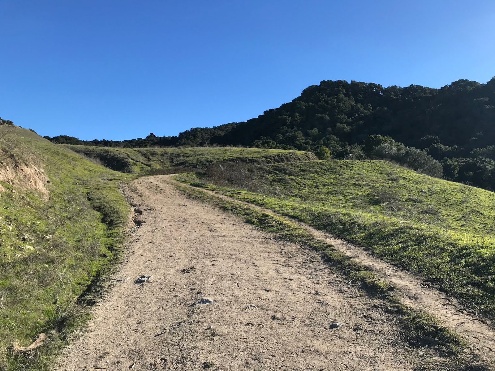
The pavement of Old Stage Road ends at the Juan Bautista De Anza trailhead which is signified by a large gate.


The Juan Bautista De Anza Trail on Old Stage Road is 4 miles in length to the Monterey County Line. The Juan Bautista De Anza Trail on Old Stage Road is fairly unique by Park Service standards given animals and bikes are allowed on it. The Juan Bautista De Anza trailhead includes a information station describing the Second De Anza expedition.


Old Stage Road begins on somewhat flat terrain which is soon broken up by a cattle guard. The starting elevation of the trail portion of Old Stage Road is approximately 350 feet above sea level and crests at about 1,100 feet three miles to the south.


The cattle guard has an advisory sign regarding mountain lions. The sign recommends hiking with others as a deterrent, to that end I've never encountered a mountain lion in any part of the Gabilan Range.


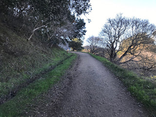
The first half mile of Old Stage Road has a very steep grade which I'd speculate is 15-20% in places. Old Stage Road does a 270 degree curve as it ascends into the Gabilan Range. The grade of Old Stage Road is in poor repair with numerous small washouts and some overgrowth. The first major incline on Old Stage Road concludes at a Park Service bench.


From the Park Service bench there is a hell of a view of the concrete surface of former US 101 on the San Juan Grade to the west.

From the Park Service bench Old Stage Road flattens and crosses a second cattle guard.


Beyond the second cattle guard is a plaque which describes Old Stage Road as being designated as part of the Juan Bautista De Anza Trail in October 1999. Beyond the plaque the City of Holister and Diablo Range can be seen to the east.


Old Stage Road begins a second steep uphill climb.


At the one mile mark of my climb of Old Stage Road I turned around to take this photo. The steep grade of Old Stage Road is an interesting contrast to the concrete San Juan Grade. One can almost envision the transition of the stage route era giving way to the automobile age in the early 20th Century.

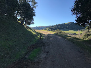
Old Stage Road continues to climb south until a clearing which overlooks San Juan Canyon and County Route G1.


The most weathered parts of Old Stage Road are encountered about a mile and half into the uphill climb. Even though the grade of Old Stage Road is weathered to bedrock I was surprised to see how well it remained intact with the lack of maintenance. I am of the opinion that a car could negotiate the San Benito County portion of Old Stage Road driving with care. A high clearance vehicle would definitely make short work of Old Stage Road.

Old Stage Road continues to climb to a second Park Service Bench which overlooks Fremont Peak. Fremont Peak is the tallest point in the Gabilan Range at 3,173 feet above sea level.


Old Stage Road continues uphill on a grade which becomes gradually more shallow.


Old Stage Road flattens out and passes through a series of wooden cliff-faces.


Old Stage Road makes one last climb southbound to a pass located three miles from the trailhead at an elevation of approximately 1,100 feet above sea level.


From the pass Salinas Valley can be seen through French Canyon. The Monterey County Line lies about one mile south of the pass at an elevation of approximately 700 feet above sea level. I turned around at the pass and made my way down hill back to the trailhead. For context even with stopping periodically to take pictures I made the six mile trip to the summit of Old Stage Road and back in 54 minutes. I'm confident in saying that as far as "trails" go the route over Old Stage Road would qualify as easy for most hikers.

To conclude this article, I am hoping to find out more regarding the annual vintage car cruise over Old Stage Road in San Benito County. I'm to understand that the car cruise takes the easier ascent on Old Stage Road through Monterey County and descends on the San Benito County side. To that end I would assume this route of travel was chosen given the the likelihood of a vintage car overheating on the large uphill grades headed south on Old Stage Road. If I find out additional information I will make an update to this article.

Part 1; the history of El Camino Real and Old Stage Road
The Gabilan Range between what is now San Juan Bautista and Salinas Valley was first explored during the second Juan Bautista De Anza Expedition of Las Californias. While the De Anza expedition likely crossed very close to the present alignment of Old Stage Route their exact path isn't clear. Juan Bautista De Anza noted the following in his journal while passing near present day San Juan Bautista on March 24, 1776:
"In the valley we saw many antelopes and white grey geese. In the same valley we found an arroyo...and then came to a village in which I counted about twenty tule huts. But the only two people we saw were two Indians who came out to the road and presented us with three fish more than a foot long."
In time the general route of the second De Anza Expedition became the path of El Camino Real ("The Royal Road"). The route of El Camino Real was intended to solidify a path of travel between the Catholic Missions of Las Californias. In 1797 Mission San Juan Bautista was founded which led to a need for a spur of El Camino Real to be built from Salinas Valley over the Gabilan Range. This spur of El Camino Real would become what is now Old Stage Road. While the Spanish El Camino Real was largely just a general path between the Missions there are identifiable paths such as Old Stage Road which can be identified conclusively as part of the highway.
In 1804 Alta California was formed out of the larger Las Californias. El Camino Real would ultimately connect 21 Catholic Missions of Alta California ranging approximately 600 miles spanning from Mission San Diego de Alcala in San Diego north to Mission San Francisco Solano in Sonoma. The Missions of El Camino Real were established from 1769 through 1823. In the case of Mission San Francisco Solano it was established two years after Mexico had won it's independence from Spain in 1821. Each Mission was meant to be approximately 30 miles apart from each other which would require a single day of travel by horseback.
Following the advent of Mexican independence from Spain the usage of the term "El Camino Real" largely fell into disuse. Following the secularization of the Spanish Missions in August of 1833 the land holdings were split off into Ranchos. Despite El Camino Real functionally no longer existing the route it's path over what is now Old Stage Road remained a popular route of travel over the Gabilan Range. What is now San Juan Bautista was founded as a town in 1834 known at the time as "San Juan de Castro."
Alta California was annexed by the United States in early 1848. San Juan Bautista became an incorporated City in 1869 (citation; San Juan Bautista Historical Society). San Juan Bautista was originally located in Monterey County but was among the land split into San Benito County in 1874. Old Stage Road remained the primary route of travel between Salinas Valley and San Juan Bautista into the 20th Century.
Old Stage Road shows up numerous American Maps as a primitive road. One such example is this 1857 Britton & Rey's Road Map of California.

Likewise Old Stage Road appears on the 1873 California Geological Survey Map of Central California as the road between Salinas Valley and San Juan Bautista.

In 1904 the American El Camino Real Association was formed with the goal to mark a modern highway that corresponded to the historical route between the Spanish Missions. Ultimately the path of American El Camino Real was to be marked by the signature bells the corridor is known by today. The first bell marking the American El Camino Real was placed in 1906 and it is estimated by 1915 that there may have been anywhere to 158 to 400 placed in-field. The American El Camino Real was one of the earliest analogs of what would become the signed Auto Trails. The American El Camino Real just as it's Spanish predecessor crossed the Gabilan Range via Old Stage Road. The background of the American El Camino Real is covered extensively on CAhighways.org.
CAhighyways.org on the American El Camino Real
The era of State Highway Maintenance through the Gablian Range would ultimately begin with the 1909 First State Highway Bond Act which was approved by voters in 1910. One of the highways approved through the 1909 First State Highway Bond Act was a 481.8 mile highway originating at the City Limits of San Francisco which terminated in San Diego. This highway would ultimately come to be known in time as Legislative Route Number 2.
Old Stage Road even by the conventions of the 1910s was woefully inadequate for usage by automobiles. The terrain of the Gabilan Range between San Juan Bautista and Salinas Valley was so rugged that an alternate route from Gilroy to Salinas by way of Watsonville and Castroville was considered. This 1913 highway proposal of LRN 2 shows what could have been an alternate highway routed west from San Juan Bautista.

Ultimately the San Juan Grade was completed by 1915 and replaced Old Stage Road as the primary highway from Salinas to San Juan Bautista. LRN 2 over the San Juan Grade can be seen as the 1920 Denny's Pocket Map of San Benito County. Note; Old State Road is shown on the 1920 Denny's Map as an abandoned road.

Ultimately LRN 2 and the San Juan Grade became part of US Route 101 in late 1926. US 101/LRN 2 was ultimately shifted west of San Juan Bautista and the San Juan Grade onto what is known as the Prunedale Cut-Off in summer of 1932. This construction of the Prunedale Cut-Off bypass route of the San Juan Grade can be seen on the October 1931 edition of the California Highways and Public Works Journal and on CAhighways.org Legislative Route 2 page.


The San Juan Grade was relinquished sometime in 1935 or 1936. It seems that at some point after 1920 maintenance of Old Stage Road was picked up by San Benito County and Monterey County. Old Stage Road appears as an active roadway on the 1935 Division of Highways Maps of San Benito County and Monterey County.
San Benito County

Monterey County

Maintenance of Old Stage Road between Monterey County and San Benito County has varied greatly. Over the recent decades Old Stage Road in Monterey County has become a normal back country roadway between US 101 near Gonzales to the San Benito County Line. Old Stage Road on the Monterey County side is a paved highway all the way to a half mile of the San Benito County Line in French Canyon of the Gabilan Range.
Within San Benito County the route of Old Stage Road is approximately 4.3 miles. From the Monterey County Line the route of Old Stage Road is a graded dirt road for 4 miles. The 4 mile dirt segment of Old Stage Road is closed to vehicles 364 days a year to the Juan Bautista De Anza Trailhead. From the Juan Bautista De Anza Trailhead the alignment of Old Stage Road continues as a paved roadway 0.3 miles to former US 101 on the San Juan Grade (signed as Salinas Road in San Benito County).
Old Stage Road within San Benito County was open to traffic until fairly recently. Presently the 4 mile dirt segment of Old Stage Road is maintained by the National Park Service as a historic portion of the Juan Bautista De Anza Trail. A local vintage car club out of Salinas opens the 4 mile dirt segment of Old Stage Road once a year generally the weekend before Mother's Day so it can maintain it's status as an active highway. Unfortunately in my research I haven't been able to track down the name of the car club involved in opening the dirt segment of Old Stage Road to vehicles.
In preparation for this article I prepared numerous maps of the San Juan Bautista and Salinas area which show the corridors of the historic highways in the the area. The route of Old Stage Road is depicted in blue below whereas former US 101 on the San Juan Grade is depicted in red. It is interesting to note how much shorter of a route Old Stage Road utilizes to cross the Gablian Range due to it's less forgiving steep grades.


Part 2; running to the summit of Old Stage Road
While passing through San Juan Bautista I had some time to stop and partake in a short hike up Old Stage Road. To reach Old Stage Road from California State Route 156 eastbound I turned south on County Route G1 onto The Alameda (part of former US 101).


To reach Old Stage Road I stayed on The Alameda and followed it to Salinas Road. County Route G1 splits away on San Juan Canyon Road towards Fremont Peak State Park.


Old Stage Road splits from Salinas Road and can easily be identified by Juan Bautista De Anza Historic Trail shield.

Old Stage Road briefly follows the alignment of the San Juan Pacific Railway which was located to the left in the photo below. The San Juan Pacific Railway had a terminus in San Juan Canyon where it hauled cement from 1907 to 1930.

The pavement of Old Stage Road ends at the Juan Bautista De Anza trailhead which is signified by a large gate.


The Juan Bautista De Anza Trail on Old Stage Road is 4 miles in length to the Monterey County Line. The Juan Bautista De Anza Trail on Old Stage Road is fairly unique by Park Service standards given animals and bikes are allowed on it. The Juan Bautista De Anza trailhead includes a information station describing the Second De Anza expedition.


Old Stage Road begins on somewhat flat terrain which is soon broken up by a cattle guard. The starting elevation of the trail portion of Old Stage Road is approximately 350 feet above sea level and crests at about 1,100 feet three miles to the south.


The cattle guard has an advisory sign regarding mountain lions. The sign recommends hiking with others as a deterrent, to that end I've never encountered a mountain lion in any part of the Gabilan Range.


The first half mile of Old Stage Road has a very steep grade which I'd speculate is 15-20% in places. Old Stage Road does a 270 degree curve as it ascends into the Gabilan Range. The grade of Old Stage Road is in poor repair with numerous small washouts and some overgrowth. The first major incline on Old Stage Road concludes at a Park Service bench.


From the Park Service bench there is a hell of a view of the concrete surface of former US 101 on the San Juan Grade to the west.

From the Park Service bench Old Stage Road flattens and crosses a second cattle guard.


Beyond the second cattle guard is a plaque which describes Old Stage Road as being designated as part of the Juan Bautista De Anza Trail in October 1999. Beyond the plaque the City of Holister and Diablo Range can be seen to the east.


Old Stage Road begins a second steep uphill climb.


At the one mile mark of my climb of Old Stage Road I turned around to take this photo. The steep grade of Old Stage Road is an interesting contrast to the concrete San Juan Grade. One can almost envision the transition of the stage route era giving way to the automobile age in the early 20th Century.

Old Stage Road continues to climb south until a clearing which overlooks San Juan Canyon and County Route G1.


The most weathered parts of Old Stage Road are encountered about a mile and half into the uphill climb. Even though the grade of Old Stage Road is weathered to bedrock I was surprised to see how well it remained intact with the lack of maintenance. I am of the opinion that a car could negotiate the San Benito County portion of Old Stage Road driving with care. A high clearance vehicle would definitely make short work of Old Stage Road.

Old Stage Road continues to climb to a second Park Service Bench which overlooks Fremont Peak. Fremont Peak is the tallest point in the Gabilan Range at 3,173 feet above sea level.


Old Stage Road continues uphill on a grade which becomes gradually more shallow.


Old Stage Road flattens out and passes through a series of wooden cliff-faces.


Old Stage Road makes one last climb southbound to a pass located three miles from the trailhead at an elevation of approximately 1,100 feet above sea level.


From the pass Salinas Valley can be seen through French Canyon. The Monterey County Line lies about one mile south of the pass at an elevation of approximately 700 feet above sea level. I turned around at the pass and made my way down hill back to the trailhead. For context even with stopping periodically to take pictures I made the six mile trip to the summit of Old Stage Road and back in 54 minutes. I'm confident in saying that as far as "trails" go the route over Old Stage Road would qualify as easy for most hikers.

To conclude this article, I am hoping to find out more regarding the annual vintage car cruise over Old Stage Road in San Benito County. I'm to understand that the car cruise takes the easier ascent on Old Stage Road through Monterey County and descends on the San Benito County side. To that end I would assume this route of travel was chosen given the the likelihood of a vintage car overheating on the large uphill grades headed south on Old Stage Road. If I find out additional information I will make an update to this article.
Comments