This past November I visited the Railroad Square Historic District in Santa Rosa of Sonoma County, California. Railroad Square is a historic corridor in downtown Santa Rosa which was created due to it being isolated due to the realignment of US Route 101.

Part 1; the history of Railroad Square and the highways of Santa Rosa
Santa Rosa is the County Seat and largest City in Sonoma County. Santa Rosa was settled in 1833 in Alta California and was named after Saint Rose of Lima. When California became an American State, Sonoma County was one of the original counties. The original County Seat of Sonoma County was in Sonoma, but it was soon moved to Santa Rosa by 1854. In 1867 Santa Rosa became an incorporated City as it was one of the few major communities north of San Francisco Bay.
Railroad service arrived at Santa Rosa in 1870 by way of the San Francisco & Northern Pacific Railroad ("SF&NP"). The SF&NP began construction from Petaluma northward in 1869. By 1870 as noted above the SF&NP reached Santa Rosa and was extended north to Cloverdale in 1872. Between 1874 and 1877 a branch spur of the SF&NP was built from Fulton west along the Russian River to Guerneville. By 1884 the SF&NP was extended south to new ferry terminal facilities in Tiburon. By 1889 the SF&NP was extended northward to Ukiah and by 1890 a spur line between Santa Rosa and Sebastopol was opened.
By the 1890s the SF&NP was struggling to remain afloat. In 1898 the Southern Pacific Railroad formed the subsidiary Northwestern Pacific Railroad Company which was intended to reach the lumber mills of Humboldt County. The SF&NP began leasing their lines to the Northwestern Pacific Railroad in 1898. In 1903 the Northwestern Pacific Railroad constructed a depot which at the western end of 4th Street. The 1904Northwestern Pacific Railroad was among many stone and masonry structures which survived the 1906 San Francisco Earthquake. By 1907 the SF&NP was merged into the Northwestern Railway as part of the Southern Pacific subsidiary.
Railroad Square in Santa Rosa refers to a neighborhood bounded by; Third Street, Davis Street, Sixth Street and Santa Rosa Creek. What is now Railroad Square can be seen on a 1877 Thomson & Company Map of Santa Rosa and Sonoma County. Note: the SF&NP can be seen just west of Wilson Street, the line still is in use by the Union Pacific.

The creation of Railroad Square can be directly attributed to US Route 101 being moved to limited access roadways. State Highway Service in Santa Rosa began with the passage of the 1909 First State Highway Bond Act which was approved by voters in 1910. The new State Highway passing through Santa Rosa was Legislative Route 1 which was plotted from the Oregon State Line to San Francisco Bay. LRN 1 headed northbound traversed Santa Rosa using the following alignment:
- Santa Rosa Avenue to Old Courthouse Square.
- Old Courthouse Square to Mendocino Avenue.
- Mendocino Avenue north out of Santa Rosa.
During the era of the Auto Trails LRN 1 through Santa Rosa became part of the Redwood Highway. On the 1920 Clason Highway Map of California the Redwood Highway can be seen aligned on LRN 1 through Santa Rosa.

During the 1919 Third State Highway Bond Act Legislative Route 51 was added to the Highway System. LRN 51 as originally defined was aligned between Santa Rosa east to Shellville. The original alignment of LRN 51 east of LRN 1 branched away via 4th Street from Mendocino Avenue. LRN 1 and LRN 51 can be seen meeting in Santa Rosa on the 1920 Division of Highways State Map.

In November 1926 the US Route System was created and US 101 was aligned LRN 1 through Santa Rosa. US 101 can be seen aligned over LRN 1 through Santa Rosa on the 1927 National Map Company sectional paved road map.

In 1933 LRN 51 was extended west through Santa Rosa to Sebastopol. LRN 51 multiplexed US 101/LRN 1 along Old Courthouse Square and Santa Rosa Avenue before splitting west along Sebastopol Road. In an 1934 Department of Public Works Publication CA 12 was announced as running through Santa Rosa on LRN 51.


In a November/December 1948 California Highway and Public Works guide the new divided highway bypass route of US 101/LRN 1 in Santa Rosa is discussed. The issues regarding US 101/LRN 1 being routed around Old Court House Square are discussed.


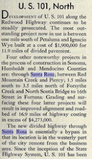

The opening of the so called "Santa Rosa Freeway" route of US 101/LRN 1 is covered extensively in an article in the May/June 1949 California Highway and Public Works Guide. The Santa Rosa Freeway opening ceremony was held on May 20th, 1949. Note; the term "freeway" was used for any divided roadway which included a grade separation. US 101/LRN 1 on the Santa Rosa Freeway as photographed in May 1949 would fall under the classification of an expressway by modern conventions. The Santa Rosa Freeway is described as a 4.3 mile section of new highway.


Subsequent to US 101/LRN 1 moving to the Santa Rosa Freeway the route of CA 12 westbound was altered north of downtown. CA 12 westbound moved off of 4th Street approaching downtown and met US 101/LRN 1 via College Avenue. US 101/CA 12 multiplexed on the Santa Rosa Freeway south to Sebastopol Road where CA 12 split west. For a time the former surface route of US 101/LRN 1 in Santa Rosa was signed as US 101A. The 1950 Division of Highways State Map was the first edition to display the Santa Rosa Freeway.

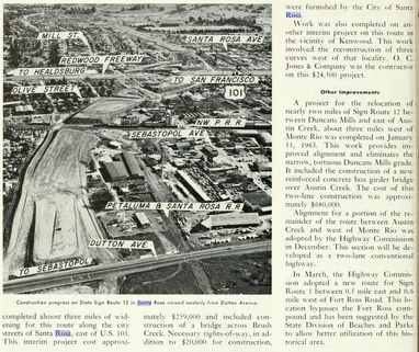
An unintended consequence of the Santa Rosa Freeway was that it divided what is now Railroad Square from the rest of downtown Santa Rosa. What is now Railroad Square began to decline as Santa began to sprawl with the greater freedom of movement provided by the Santa Rosa Freeway. From 1950 to 1960 Santa Rosa almost doubled in size from approximately 17,000 residents to 31,000 residents. In a May/June 1963 California Highways and Public Works Guide the ongoing project to build US 101 within Sonoma County is discussed along with a new freeway route for CA 12 near Sebastopol and Santa Rosa.


The November/December 1963 California Highways and Public Works Guide states that the new freeway alignment of CA 12 in Santa Rosa was slated to open in Spring 1964.

The May/June 1965 California Highways and Public Works Guide discusses the CA 12 freeway through Santa Rosa being completed in December of 1964.


CA 12 appears as a freeway on the 1965 Division of Highway State Map.

A 1.1 mile segment of US 101 in Santa Rosa is cited as being converted to full freeway standards in Spring 1965 in the November/December 1965 California Highways and Public Works Guide.

In 1979 Railroad Square was added to the National Register of Historic Places. The adding of Railroad Square to the NRHP began efforts to revitalize the neighborhood which has in recent decades become a notable tourism draw for visitors in Sonoma County.
Part 2; exploring the US 101/CA 12 interchange and Railroad Square
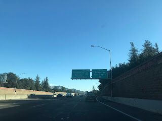
After visiting the Charles M. Schulz Museum I found myself with a significant amount of time left to kill. I decided to head southbound on US 101 towards the interchange with CA 12 to access Railroad Square. I took US 101 south Exit 488 to access Railroad Square via Davis Street.


I parked at 4th Street and Wilson Street near the 1904 Northwest Pacific Depot.
Located at the southeast corner of 4th and Wilson is the 1906 Lee Brothers Building. While Santa Rosa isn't located in the Gold Rush Regions of California the masonry buildings of Railroad Square have the feel of the Gold Rush era.

The 1904 Northwestern Pacific Depot is located in Santa Rosa Depot Park. Note; Peanuts characters can be observed in sculpture form near the 1904 Northwestern Pacific Depot.


A new rail platform for the Sonoma-Marin SMART service opened in 2017 behind the 1904 Northwestern Pacific Depot.

From the new train platform some ruins of what was probably a freight loading facility along Santa Rosa Creek can be seen.


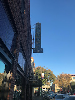
The Western Hotel is located directly south of the 1904 Northwestern Pacific Depot and presently a coffee shop.

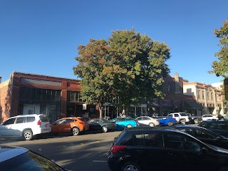
The sights along 4th Street headed east from Wilson Street.


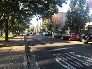
The view at the corner of Davis Street and 5th Street looking north.


The Hotel La Rose was constructed in 1907 and is one of the more notable structures in Railroad Square. This photo of the Hotel La Rose was from 5th Street approaching Wilson Street.

The view from Wilson Street looking south from 4th Street in the first photo and looking north in the second.


Part 1; the history of Railroad Square and the highways of Santa Rosa
Santa Rosa is the County Seat and largest City in Sonoma County. Santa Rosa was settled in 1833 in Alta California and was named after Saint Rose of Lima. When California became an American State, Sonoma County was one of the original counties. The original County Seat of Sonoma County was in Sonoma, but it was soon moved to Santa Rosa by 1854. In 1867 Santa Rosa became an incorporated City as it was one of the few major communities north of San Francisco Bay.
Railroad service arrived at Santa Rosa in 1870 by way of the San Francisco & Northern Pacific Railroad ("SF&NP"). The SF&NP began construction from Petaluma northward in 1869. By 1870 as noted above the SF&NP reached Santa Rosa and was extended north to Cloverdale in 1872. Between 1874 and 1877 a branch spur of the SF&NP was built from Fulton west along the Russian River to Guerneville. By 1884 the SF&NP was extended south to new ferry terminal facilities in Tiburon. By 1889 the SF&NP was extended northward to Ukiah and by 1890 a spur line between Santa Rosa and Sebastopol was opened.
By the 1890s the SF&NP was struggling to remain afloat. In 1898 the Southern Pacific Railroad formed the subsidiary Northwestern Pacific Railroad Company which was intended to reach the lumber mills of Humboldt County. The SF&NP began leasing their lines to the Northwestern Pacific Railroad in 1898. In 1903 the Northwestern Pacific Railroad constructed a depot which at the western end of 4th Street. The 1904Northwestern Pacific Railroad was among many stone and masonry structures which survived the 1906 San Francisco Earthquake. By 1907 the SF&NP was merged into the Northwestern Railway as part of the Southern Pacific subsidiary.
Railroad Square in Santa Rosa refers to a neighborhood bounded by; Third Street, Davis Street, Sixth Street and Santa Rosa Creek. What is now Railroad Square can be seen on a 1877 Thomson & Company Map of Santa Rosa and Sonoma County. Note: the SF&NP can be seen just west of Wilson Street, the line still is in use by the Union Pacific.

The creation of Railroad Square can be directly attributed to US Route 101 being moved to limited access roadways. State Highway Service in Santa Rosa began with the passage of the 1909 First State Highway Bond Act which was approved by voters in 1910. The new State Highway passing through Santa Rosa was Legislative Route 1 which was plotted from the Oregon State Line to San Francisco Bay. LRN 1 headed northbound traversed Santa Rosa using the following alignment:
- Santa Rosa Avenue to Old Courthouse Square.
- Old Courthouse Square to Mendocino Avenue.
- Mendocino Avenue north out of Santa Rosa.
During the era of the Auto Trails LRN 1 through Santa Rosa became part of the Redwood Highway. On the 1920 Clason Highway Map of California the Redwood Highway can be seen aligned on LRN 1 through Santa Rosa.

During the 1919 Third State Highway Bond Act Legislative Route 51 was added to the Highway System. LRN 51 as originally defined was aligned between Santa Rosa east to Shellville. The original alignment of LRN 51 east of LRN 1 branched away via 4th Street from Mendocino Avenue. LRN 1 and LRN 51 can be seen meeting in Santa Rosa on the 1920 Division of Highways State Map.

In November 1926 the US Route System was created and US 101 was aligned LRN 1 through Santa Rosa. US 101 can be seen aligned over LRN 1 through Santa Rosa on the 1927 National Map Company sectional paved road map.

In 1933 LRN 51 was extended west through Santa Rosa to Sebastopol. LRN 51 multiplexed US 101/LRN 1 along Old Courthouse Square and Santa Rosa Avenue before splitting west along Sebastopol Road. In an 1934 Department of Public Works Publication CA 12 was announced as running through Santa Rosa on LRN 51.


In a November/December 1948 California Highway and Public Works guide the new divided highway bypass route of US 101/LRN 1 in Santa Rosa is discussed. The issues regarding US 101/LRN 1 being routed around Old Court House Square are discussed.


The opening of the so called "Santa Rosa Freeway" route of US 101/LRN 1 is covered extensively in an article in the May/June 1949 California Highway and Public Works Guide. The Santa Rosa Freeway opening ceremony was held on May 20th, 1949. Note; the term "freeway" was used for any divided roadway which included a grade separation. US 101/LRN 1 on the Santa Rosa Freeway as photographed in May 1949 would fall under the classification of an expressway by modern conventions. The Santa Rosa Freeway is described as a 4.3 mile section of new highway.


Subsequent to US 101/LRN 1 moving to the Santa Rosa Freeway the route of CA 12 westbound was altered north of downtown. CA 12 westbound moved off of 4th Street approaching downtown and met US 101/LRN 1 via College Avenue. US 101/CA 12 multiplexed on the Santa Rosa Freeway south to Sebastopol Road where CA 12 split west. For a time the former surface route of US 101/LRN 1 in Santa Rosa was signed as US 101A. The 1950 Division of Highways State Map was the first edition to display the Santa Rosa Freeway.

An unintended consequence of the Santa Rosa Freeway was that it divided what is now Railroad Square from the rest of downtown Santa Rosa. What is now Railroad Square began to decline as Santa began to sprawl with the greater freedom of movement provided by the Santa Rosa Freeway. From 1950 to 1960 Santa Rosa almost doubled in size from approximately 17,000 residents to 31,000 residents. In a May/June 1963 California Highways and Public Works Guide the ongoing project to build US 101 within Sonoma County is discussed along with a new freeway route for CA 12 near Sebastopol and Santa Rosa.

The November/December 1963 California Highways and Public Works Guide states that the new freeway alignment of CA 12 in Santa Rosa was slated to open in Spring 1964.
The May/June 1965 California Highways and Public Works Guide discusses the CA 12 freeway through Santa Rosa being completed in December of 1964.
CA 12 appears as a freeway on the 1965 Division of Highway State Map.

A 1.1 mile segment of US 101 in Santa Rosa is cited as being converted to full freeway standards in Spring 1965 in the November/December 1965 California Highways and Public Works Guide.
In 1979 Railroad Square was added to the National Register of Historic Places. The adding of Railroad Square to the NRHP began efforts to revitalize the neighborhood which has in recent decades become a notable tourism draw for visitors in Sonoma County.
Part 2; exploring the US 101/CA 12 interchange and Railroad Square
After visiting the Charles M. Schulz Museum I found myself with a significant amount of time left to kill. I decided to head southbound on US 101 towards the interchange with CA 12 to access Railroad Square. I took US 101 south Exit 488 to access Railroad Square via Davis Street.


I parked at 4th Street and Wilson Street near the 1904 Northwest Pacific Depot.

Located at the southeast corner of 4th and Wilson is the 1906 Lee Brothers Building. While Santa Rosa isn't located in the Gold Rush Regions of California the masonry buildings of Railroad Square have the feel of the Gold Rush era.

The 1904 Northwestern Pacific Depot is located in Santa Rosa Depot Park. Note; Peanuts characters can be observed in sculpture form near the 1904 Northwestern Pacific Depot.


A new rail platform for the Sonoma-Marin SMART service opened in 2017 behind the 1904 Northwestern Pacific Depot.

From the new train platform some ruins of what was probably a freight loading facility along Santa Rosa Creek can be seen.


The Western Hotel is located directly south of the 1904 Northwestern Pacific Depot and presently a coffee shop.

The sights along 4th Street headed east from Wilson Street.


The view at the corner of Davis Street and 5th Street looking north.


The Hotel La Rose was constructed in 1907 and is one of the more notable structures in Railroad Square. This photo of the Hotel La Rose was from 5th Street approaching Wilson Street.

The view from Wilson Street looking south from 4th Street in the first photo and looking north in the second.


Comments